Volume 2-05, Chapter 3 - City of Wichita
Volume 2-05, Chapter 3 - City of Wichita
Volume 2-05, Chapter 3 - City of Wichita

Create successful ePaper yourself
Turn your PDF publications into a flip-book with our unique Google optimized e-Paper software.
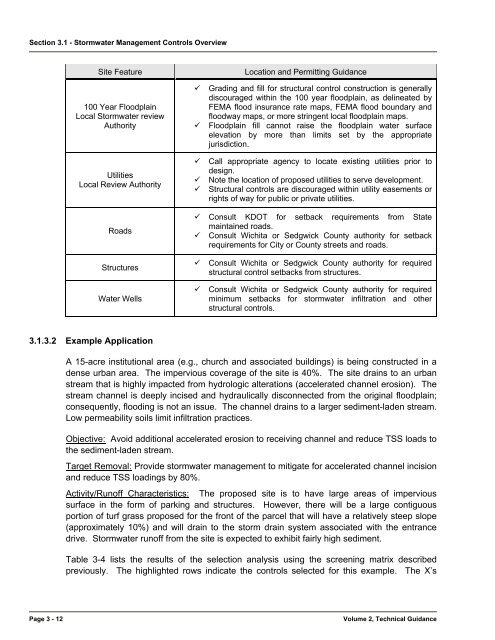
Section 3.1 - Stormwater Management Controls Overview<br />
Site Feature<br />
100 Year Floodplain<br />
Local Stormwater review<br />
Authority<br />
Utilities<br />
Local Review Authority<br />
Roads<br />
Structures<br />
Water Wells<br />
Location and Permitting Guidance<br />
Grading and fill for structural control construction is generally<br />
discouraged within the 100 year floodplain, as delineated by<br />
FEMA flood insurance rate maps, FEMA flood boundary and<br />
floodway maps, or more stringent local floodplain maps.<br />
Floodplain fill cannot raise the floodplain water surface<br />
elevation by more than limits set by the appropriate<br />
jurisdiction.<br />
Call appropriate agency to locate existing utilities prior to<br />
design.<br />
Note the location <strong>of</strong> proposed utilities to serve development.<br />
Structural controls are discouraged within utility easements or<br />
rights <strong>of</strong> way for public or private utilities.<br />
Consult KDOT for setback requirements from State<br />
maintained roads.<br />
Consult <strong>Wichita</strong> or Sedgwick County authority for setback<br />
requirements for <strong>City</strong> or County streets and roads.<br />
Consult <strong>Wichita</strong> or Sedgwick County authority for required<br />
structural control setbacks from structures.<br />
Consult <strong>Wichita</strong> or Sedgwick County authority for required<br />
minimum setbacks for stormwater infiltration and other<br />
structural controls.<br />
3.1.3.2 Example Application<br />
A 15-acre institutional area (e.g., church and associated buildings) is being constructed in a<br />
dense urban area. The impervious coverage <strong>of</strong> the site is 40%. The site drains to an urban<br />
stream that is highly impacted from hydrologic alterations (accelerated channel erosion). The<br />
stream channel is deeply incised and hydraulically disconnected from the original floodplain;<br />
consequently, flooding is not an issue. The channel drains to a larger sediment-laden stream.<br />
Low permeability soils limit infiltration practices.<br />
Objective: Avoid additional accelerated erosion to receiving channel and reduce TSS loads to<br />
the sediment-laden stream.<br />
Target Removal: Provide stormwater management to mitigate for accelerated channel incision<br />
and reduce TSS loadings by 80%.<br />
Activity/Run<strong>of</strong>f Characteristics: The proposed site is to have large areas <strong>of</strong> impervious<br />
surface in the form <strong>of</strong> parking and structures. However, there will be a large contiguous<br />
portion <strong>of</strong> turf grass proposed for the front <strong>of</strong> the parcel that will have a relatively steep slope<br />
(approximately 10%) and will drain to the storm drain system associated with the entrance<br />
drive. Stormwater run<strong>of</strong>f from the site is expected to exhibit fairly high sediment.<br />
Table 3-4 lists the results <strong>of</strong> the selection analysis using the screening matrix described<br />
previously. The highlighted rows indicate the controls selected for this example. The X’s<br />
Page 3 - 12<br />
<strong>Volume</strong> 2, Technical Guidance