Bay Vista Subarea Plan Draft - September 2012 - City of Bremerton
Bay Vista Subarea Plan Draft - September 2012 - City of Bremerton
Bay Vista Subarea Plan Draft - September 2012 - City of Bremerton

Create successful ePaper yourself
Turn your PDF publications into a flip-book with our unique Google optimized e-Paper software.
DRAFT<br />
<strong>September</strong> 18, <strong>2012</strong><br />
<strong>Bay</strong> <strong>Vista</strong><br />
SUB-AREA PLAN<br />
prepared by:
<strong>September</strong> 18, <strong>2012</strong><br />
BAY VISTA SUB-AREA PLAN<br />
BREMERTON HOUSING AUTHORITY<br />
AMENDMENT PRODUCED BY<br />
BCRA<br />
bay vista
I - INTRODUCTION<br />
A. Site Location & History ..............................................................................................................................................................<br />
B. Sub-Area <strong>Plan</strong> Vision ..................................................................................................................................................................<br />
C. Organization <strong>of</strong> Sub-Area <strong>Plan</strong> ...................................................................................................................................................<br />
1<br />
1<br />
1<br />
2<br />
II - BAY VISTA SUB-AREA PLAN<br />
A. Local <strong>Plan</strong>ning Framework .........................................................................................................................................................<br />
B. Consistency <strong>of</strong> the Sub-Area <strong>Plan</strong> with <strong>Bremerton</strong>’s Comprehensive <strong>Plan</strong> ...............................................................................<br />
C. Public/Stakeholder Process .......................................................................................................................................................<br />
D. SEPA/NEPA Environmental Review ............................................................................................................................................<br />
E. <strong>Bay</strong> <strong>Vista</strong> Architectural Review Committee ...............................................................................................................................<br />
4<br />
4<br />
5<br />
8<br />
12<br />
12<br />
III - BAY VISTA SUB-AREA PLAN<br />
13<br />
A. Existing Site conditions ..............................................................................................................................................................<br />
B. Sub-Area <strong>Plan</strong> Vision, Goals and Objectives ..............................................................................................................................<br />
C. Sub-Area <strong>Plan</strong> Elements ............................................................................................................................................................<br />
D. Future Changes to the Sub Area <strong>Plan</strong> ........................................................................................................................................<br />
IV - ZONING & DEVELOPMENT REGULATIONS<br />
A. Land Use Zones ..........................................................................................................................................................................<br />
B. General Development Standards ...............................................................................................................................................<br />
C. Streets, Sidewalks And Driveways .............................................................................................................................................<br />
D. Low Impact Development ..........................................................................................................................................................<br />
E. Parking Standards ......................................................................................................................................................................<br />
F. Landscape Standards .................................................................................................................................................................<br />
G. Utility Equipment & Storage ......................................................................................................................................................<br />
H. Walls, Hedges And Fences .........................................................................................................................................................<br />
I. Exterior Lighting .........................................................................................................................................................................<br />
J. Sign Standards ...........................................................................................................................................................................<br />
K. Glossary .....................................................................................................................................................................................<br />
Intent .........................................................................................................................................................................................<br />
A. General Site Layout and Building Orientation ...........................................................................................................................<br />
13<br />
15<br />
17<br />
22<br />
23<br />
23<br />
31<br />
31<br />
33<br />
34<br />
36<br />
46<br />
46<br />
48<br />
48<br />
54<br />
57<br />
58<br />
TABLE OF CONTENTS<br />
bay vista
I - INTRODUCTION<br />
A. SITE LOCATION & HISTORY<br />
B. SUB-AREA PLAN VISION<br />
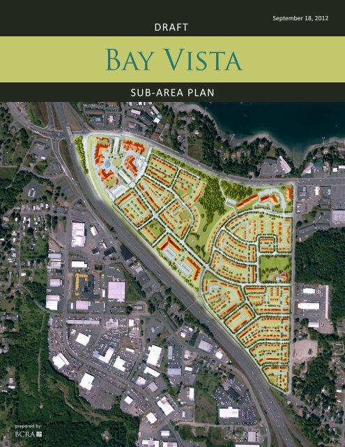
The 83-acre <strong>Bay</strong> <strong>Vista</strong> (formerly Westpark) site is<br />
located in West <strong>Bremerton</strong>, bounded by Kitsap Way<br />
on the north, Oyster <strong>Bay</strong> Avenue on the east, and State<br />
Route 3 on the west.<br />
The existing Westpark public housing community<br />
was built in 1941 and is owned and operated by the<br />
<strong>Bremerton</strong> Housing Authority (BHA). The community<br />
is the remnant <strong>of</strong> a larger World War II – era housing<br />
project that was built as temporary housing for<br />
shipyard workers. The site currently contains 631<br />
residential units, primarily one-story duplex and<br />
four-plex in design, and a 60-unit apartment building<br />
for elderly and disabled residents. Ninety percent or<br />
more <strong>of</strong> existing units are for low-income families<br />
and individuals. The site also provides community<br />
functions (a community center, senior center, teen<br />
center, and head start facility) and some local services<br />
(laundry, storage facilities, maintenance shop, and<br />
administrative <strong>of</strong>fices. A new 72-unit assisted living<br />
facility (<strong>Bay</strong> <strong>Vista</strong> Commons) was constructed and<br />
opened in December <strong>of</strong> 2007.<br />
The surrounding neighborhood contains a mix<br />
<strong>of</strong> residential, commercial and industrial land<br />
uses, including auto-oriented and larger retail uses<br />
along Kitsap Way. Kitsap Way in this area serves as<br />
a “gateway” to the <strong>City</strong> <strong>of</strong> <strong>Bremerton</strong>, though it is<br />
currently lacking in definition.<br />
The Westpark Sub-Area <strong>Plan</strong> was originally adopted in<br />
2007. The <strong>Bremerton</strong> Housing Authority (BHA) voted<br />
to change the name <strong>of</strong> the site and master plan to <strong>Bay</strong><br />
<strong>Vista</strong> in 2008. Consequently, the name <strong>of</strong> the Sub-Area<br />
<strong>Plan</strong> has also been changed to <strong>Bay</strong> <strong>Vista</strong> as part <strong>of</strong> the<br />
2009 amendment to this plan. The vision and Sub-Area<br />
<strong>Plan</strong> for <strong>Bay</strong> <strong>Vista</strong>, including the 2009 amendments,<br />
was created in consultation with stakeholders, residents<br />
and neighbors. It used an intensive design charrette<br />
process and numerous community meetings, which<br />
are summarized in Section II. Development <strong>of</strong> the<br />
Sub-Area <strong>Plan</strong> also used environmental analysis,<br />
including preparation <strong>of</strong> a SEPA/NEPA environmental<br />
impact statement (EIS), and two EIS addenda, to<br />
inform master planning <strong>of</strong> the site consistent with<br />
environmental constraints and opportunities.<br />
The Sub-Area <strong>Plan</strong> concept is built upon six major<br />
goals:<br />
1. Promoting a mixed-use, mixed-income traditional<br />
neighborhood.<br />
2. Creating a pedestrian-oriented environment.<br />
3. Maintaining/enhancing view corridors and landscaping.<br />
4. Enhancing the civic realm and creating more usable<br />
public open space.<br />
5. Promoting economic development through provision<br />
<strong>of</strong> commercial activities and services on-site and in the<br />
adjacent Neighborhood Center.<br />
section I : INTRODUCTION<br />
6. Integrating low impact development (LID) approaches<br />
into the Master <strong>Plan</strong>.<br />
The new <strong>Bay</strong> <strong>Vista</strong> is envisioned as an urban mixed-use,<br />
mixed-income, pedestrian-oriented community. It<br />
will be characterized by a variety <strong>of</strong> types and styles<br />
<strong>of</strong> housing to meet the needs <strong>of</strong> a range <strong>of</strong> income<br />
groups. Accommodating these groups will help to<br />
de-concentrate low-income housing in <strong>Bremerton</strong>.<br />
Retail and commercial uses will provide for some<br />
<strong>of</strong> the everyday shopping needs <strong>of</strong> residents, as<br />
well as provide job opportunities for residents.<br />
The retail center will provide financial support<br />
bay vista 1
section I : INTRODUCTION<br />
for implementation <strong>of</strong> the master plan, including<br />
construction <strong>of</strong> new infrastructure. <strong>Bay</strong> <strong>Vista</strong>'s<br />
on-site population will also provide support for<br />
additional commercial activity in the future Oyster <strong>Bay</strong><br />
Neighborhood Center.<br />
The site will be sensitively designed to maintain<br />
significant open space and existing trees, to preserve<br />
and enhance views, and to carefully manage<br />
stormwater and other natural features. New parks,<br />
civic spaces and outdoor amenities will be created.<br />
Proposed development standards and Design<br />
Standards, and covenants, conditions and restrictions<br />
(CC&Rs), will establish high standards for the quality<br />
<strong>of</strong> redevelopment, yet provide flexibility to respond<br />
to market changes and opportunities. The plan will<br />
provide high quality infrastructure and services<br />
to residents. The <strong>Bay</strong> <strong>Vista</strong> site will relate to the<br />
surrounding neighborhood in terms <strong>of</strong> activities and<br />
scale, and provide a catalyst and model for future<br />
redevelopment.<br />
C. ORGANIZATION OF SUB-AREA<br />
PLAN<br />
The Sub-Area <strong>Plan</strong> is organized in four major sections.<br />
Following this introduction, Section II describes<br />
the major objectives <strong>of</strong> the <strong>Plan</strong>, and its planning<br />
regulatory context within which it has been created.<br />
Section II also delineates the public/stakeholder<br />
process and SEPA/NEPA compliance for the plan<br />
are also described. Section III describes existing site<br />
conditions, and the vision, goals and objectives for<br />
redevelopment <strong>of</strong> <strong>Bay</strong> <strong>Vista</strong>. The major elements<br />
<strong>of</strong> the Sub-Area <strong>Plan</strong>–land use, housing, parks and<br />
open space, roads and infrastructure–are described<br />
in narrative and graphics. This section has been<br />
adopted by the <strong>City</strong> as an element <strong>of</strong> the <strong>Bremerton</strong><br />
Comprehensive <strong>Plan</strong>. Section IV contains the zoning<br />
and development standards that will apply to <strong>Bay</strong> <strong>Vista</strong>,<br />
including regulations for uses, density, building heights,<br />
setbacks and similar components <strong>of</strong> development.<br />
2<br />
<strong>September</strong> 18, <strong>2012</strong> •Working <strong>Draft</strong>
VICINITY MAP<br />
section I : INTRODUCTION<br />
bay vista 3
II - BAY VISTA SUB-AREA PLAN<br />
Purpose, Process, and Consistency with the Comprehensive <strong>Plan</strong><br />
Section II : purpose, process & consistency<br />
The <strong>Bay</strong> <strong>Vista</strong> Sub-Area <strong>Plan</strong> is intended to provide<br />
a road map for future redevelopment <strong>of</strong> the site.<br />
It articulates the vision, goals and objectives for<br />
redevelopment <strong>of</strong> <strong>Bay</strong> <strong>Vista</strong>, and embodies the policies<br />
<strong>of</strong> the <strong>City</strong> <strong>of</strong> <strong>Bremerton</strong> Comprehensive <strong>Plan</strong>, which<br />
it supplements. The <strong>Plan</strong> also establishes zoning<br />
standards which will guide the preparation <strong>of</strong> future<br />
site development plans, subdivisions and building<br />
permits by applicants; installation <strong>of</strong> infrastructure<br />
by the <strong>Bremerton</strong> Housing Authority (BHA) and<br />
individual developers; and review <strong>of</strong> these plans<br />
by the <strong>City</strong> <strong>of</strong> <strong>Bremerton</strong> (<strong>City</strong>) and the <strong>Bay</strong> <strong>Vista</strong><br />
Architectural Review Committee (ARC). The Sub-Area<br />
<strong>Plan</strong> reflects the Redevelopment Master <strong>Plan</strong> for <strong>Bay</strong><br />
<strong>Vista</strong> prepared by the <strong>Bremerton</strong> Housing Authority. It<br />
is also responsive to environmental impacts identified<br />
in <strong>Bay</strong> <strong>Vista</strong> environmental documents, to financial<br />
constraints, and to changing market conditions.<br />
The Westpark Sub-Area <strong>Plan</strong> was initially adopted in<br />
2007. Following additional community involvement,<br />
public hearings and environmental review,<br />
amendments were proposed to reflect the BHA's<br />
ongoing planning, as well as updated information<br />
about site constraints and market conditions. In fall<br />
2008, the BHA received a HOPE VI grant from the<br />
U.S. Department <strong>of</strong> Housing and Urban Development.<br />
Conditions <strong>of</strong> the grant include a maximum 54-month<br />
schedule for completion <strong>of</strong> construction. The Sub-Area<br />
<strong>Plan</strong> was amended by the <strong>City</strong> Council in 2009 to<br />
reflect this constraint and other changed conditions<br />
noted previously.<br />
A. LOCAL PLANNING<br />
FRAMEWORK<br />
OVERVIEW<br />
The <strong>Bay</strong> <strong>Vista</strong> site has been the subject <strong>of</strong> several <strong>City</strong><br />
legislative actions over the past few years and was also<br />
addressed specifically in the <strong>City</strong>’s recent adoption <strong>of</strong><br />
its updated Comprehensive <strong>Plan</strong> and zoning code in<br />
2004. These actions have provided a framework for<br />
planning redevelopment <strong>of</strong> the site.<br />
In <strong>September</strong> 2003, the <strong>City</strong> amended its Community<br />
Renewal <strong>Plan</strong>, pursuant to the state Community<br />
Renewal Law (RCW 35.81), to incorporate the site<br />
as a “blighted” area for purposes <strong>of</strong> community<br />
renewal efforts (Ordinance No. 4830 and 4870). The<br />
designation was supported by findings that the site<br />
was isolated from adjacent areas that building size and<br />
design were deficient, and that physical deterioration<br />
was a contributing factor to disinvestment in the<br />
area. These actions also reaffirmed the <strong>City</strong>’s intent to<br />
cooperate and assist the <strong>Bremerton</strong> Housing Authority<br />
in the redevelopment <strong>of</strong> the site, (pursuant to RCW<br />
35.83), and to provide a framework for redevelopment<br />
in the Comprehensive <strong>Plan</strong> and zoning regulations.<br />
This framework is described below.<br />
PUBLIC SECTOR REDEVELOPMENT SITE (PSRS)<br />
The Comprehensive <strong>Plan</strong> Land Use Map designates<br />
Westpark (now <strong>Bay</strong> <strong>Vista</strong>) as a Public Sector<br />
Redevelopment Site (PSRS). These are special,<br />
large-scale sites with high potential for development<br />
that is innovative or that meets a unique community<br />
need. They should be developed consistent with<br />
specific district planning efforts that address the site,<br />
compatibility with surrounding uses, and consistency<br />
with the Comprehensive <strong>Plan</strong>. A PSRS must have a<br />
clearly defined community benefit, such as meeting<br />
a public housing need. They may include mixed<br />
type residential development with an open space<br />
component and secondary commercial or <strong>of</strong>fice<br />
development.<br />
4<br />
<strong>September</strong> 18, <strong>2012</strong> •Working <strong>Draft</strong>
OYSTER BAY NEIGHBORHOOD CENTER<br />
The Comprehensive <strong>Plan</strong> designates a future<br />
Neighborhood Center for the Oyster <strong>Bay</strong> Area adjacent<br />
to the <strong>Bay</strong> <strong>Vista</strong> site, located on both sides <strong>of</strong> Kitsap<br />
Way. This 37-acre center is projected to redevelop over<br />
time in conjunction with, but slower than, <strong>Bay</strong> <strong>Vista</strong>,<br />
and to transition into an urban, pedestrian-friendly<br />
area connected with the surrounding area by trails,<br />
open space, and access to the shoreline. The Center<br />
will include a core, with mixed-use (residential<br />
and commercial) buildings. The Center will receive<br />
economic support from the surrounding neighborhood,<br />
including <strong>Bay</strong> <strong>Vista</strong>’s residents and workers; land<br />
uses in <strong>Bay</strong> <strong>Vista</strong> are expected to complement<br />
redevelopment <strong>of</strong> Oyster <strong>Bay</strong>. A Sub-Area <strong>Plan</strong> will<br />
be prepared for the Oyster <strong>Bay</strong> Center; however, the<br />
timing <strong>of</strong> this planning effort is uncertain.<br />
SPECIFIC AREA PLANS<br />
The Comprehensive <strong>Plan</strong> anticipates that more detailed<br />
area-specific plans will be developed to implement<br />
Public Sector Redevelopment Sites, such as <strong>Bay</strong><br />
<strong>Vista</strong>. Key aspects <strong>of</strong> these plans include: a process<br />
that involves the community, consistency with the<br />
Comprehensive <strong>Plan</strong> goals and policies, and inclusion<br />
<strong>of</strong> development standards and design standards. The<br />
<strong>Bay</strong> <strong>Vista</strong> Sub-Area <strong>Plan</strong> is such a specific area plan<br />
and has been developed to meet these requirements.<br />
The relationship to the Comprehensive <strong>Plan</strong> goals is<br />
discussed below.<br />
Revision <strong>of</strong> the <strong>Bay</strong> <strong>Vista</strong> Sub-Area <strong>Plan</strong> follows<br />
the <strong>City</strong>'s established process for amending the<br />
Comprehensive <strong>Plan</strong>. This process includes public<br />
involvement, environmental review, and public<br />
hearings by the <strong>Plan</strong>ning Commission and <strong>City</strong><br />
Council. In cooperation with the <strong>City</strong>, the BHA<br />
sponsored eight community meetings and workshops<br />
in the fall <strong>of</strong> 2008 to gain input on proposed changes<br />
to the Sub-Area <strong>Plan</strong>. An addendum to the Westpark<br />
EIS was also prepared to address the proposed changes.<br />
The revisions were adopted following public hearings<br />
by the <strong>Plan</strong>ning Commission and the <strong>City</strong> Council.<br />
B. CONSISTENCY OF THE SUB-<br />
AREA PLAN WITH BREMERTON’S<br />
COMPREHENSIVE PLAN<br />
BREMERTON COMPREHENSIVE PLAN -<br />
CENTERS CONCEPT<br />
The city’s updated Comprehensive <strong>Plan</strong> is based on<br />
a “Centers” concept, in which a significant portion <strong>of</strong><br />
the <strong>City</strong>’s future growth will be guided to numerous<br />
Centers designated throughout the <strong>City</strong>. Centers<br />
vary in scale, function and character, and each is<br />
intended to be a distinct district or “village” with<br />
a unique character. Designated centers range from<br />
the <strong>City</strong> Center, which provides a wide range <strong>of</strong><br />
activities that serve the entire <strong>City</strong> and the region, to<br />
smaller neighborhood centers, which provide goods<br />
and services, and amenities to residents within a<br />
neighborhood. In general, centers are intended to be<br />
mixed-use, pedestrian-friendly, well-designed areas<br />
with open space, public gathering places, access to<br />
transit, and adequate infrastructure.<br />
SHAPING BREMERTON THEMES<br />
1. Distinctive Growth, with Viable Neighborhoods and<br />
Centers that Provide Greater Choice and Convenience.<br />
Redevelopment <strong>of</strong> <strong>Bay</strong> <strong>Vista</strong> will help to revitalize<br />
an existing neighborhood that is characterized by<br />
outdated, deteriorated housing and infrastructure,<br />
and has been designated as “blighted.” The new<br />
<strong>Bay</strong> <strong>Vista</strong> neighborhood will be characterized by<br />
mixed-use development, a wide range <strong>of</strong> housing<br />
options affordable to a mix <strong>of</strong> income groups, ample<br />
open space and amenities, pedestrian accessibility,<br />
quality design, improved infrastructure and enhanced<br />
environmental resources. Everyday goods and services,<br />
and local employment opportunities, will be provided<br />
on-site.<br />
2. Enticing New Development, with a Focus on the<br />
Downtown Regional Center.<br />
The <strong>Bremerton</strong> Housing Authority has been working<br />
closely with the <strong>City</strong> and the broader community<br />
to shape a plan for <strong>Bay</strong> <strong>Vista</strong> that fits the site<br />
and is responsive to the <strong>City</strong>’s requirements and<br />
needs, including economic development, housing<br />
Section II : purpose, process & consistency<br />
bay vista 5
opportunities and population support for the future<br />
Oyster <strong>Bay</strong> Neighborhood Center. The <strong>City</strong>’s updated<br />
Comprehensive <strong>Plan</strong> and development regulations<br />
provide guidance and flexibility for large public parcel<br />
development proposals like <strong>Bay</strong> <strong>Vista</strong>.<br />
and apartments. Units will be for-sale and for-rent,<br />
market-rate apartments and public housing. All<br />
existing public housing units will be replaced either<br />
on-site (190 units) or <strong>of</strong>f-site, which will be consistent<br />
with the <strong>City</strong>’s desire to disperse public housing.<br />
Section II : purpose, process & consistency<br />
3. Supportive Transportation, with Seamless, Efficient<br />
and Varied Choices.<br />
Regional transportation facilities bounding the <strong>Bay</strong><br />
<strong>Vista</strong> site include State Route (SR) 3, Kitsap Way and<br />
Oyster <strong>Bay</strong> Avenue. Access to the site is provided by<br />
Oyster <strong>Bay</strong> Avenue, Sinclair Drive, Arsenal Way and<br />
Sand Dollar Drive.<br />
Kitsap Transit provides public transit service to the<br />
<strong>City</strong> <strong>of</strong> <strong>Bremerton</strong>. Routes No. 24 and 26 serve the <strong>Bay</strong><br />
<strong>Vista</strong> site, with stops along Kitsap Way (Route 24) and<br />
at the Firs Apartments on Oyster <strong>Bay</strong> Avenue (Route<br />
26).<br />
Kitsap Way has a designated bicycle lane, wide<br />
shoulders, raised sidewalks on both sides, and painted<br />
crosswalks with pedestrian call buttons. The <strong>City</strong><br />
<strong>of</strong> <strong>Bremerton</strong> has recently upgraded or added new<br />
accessible ramps at various intersections along Kitsap<br />
Way. A mid-block pedestrian crossing is located east <strong>of</strong><br />
Oyster <strong>Bay</strong> Avenue. Oyster <strong>Bay</strong> Avenue includes raised<br />
sidewalks on one side <strong>of</strong> the street.<br />
Levels <strong>of</strong> service at major intersections will meet <strong>City</strong><br />
<strong>of</strong> <strong>Bremerton</strong> standards.<br />
4. Improved Accessibility, especially for the Pedestrian.<br />
The <strong>Bay</strong> <strong>Vista</strong> site is being planned to support multiple<br />
transportation modes, including vehicles (through<br />
adequate access and parking); transit (through higher<br />
urban densities and access to the regional road system);<br />
and pedestrians (by integrating trails and pedestrian<br />
amenities in a mixed-use development pattern).<br />
5. Quality Housing, with Broader Choices.<br />
Existing housing on the site is old and deficient; the<br />
Comprehensive <strong>Plan</strong> and several <strong>City</strong> ordinances have<br />
identified the site’s housing as substandard and in<br />
need <strong>of</strong> revitalization. The redeveloped <strong>Bay</strong> <strong>Vista</strong> will<br />
provide approximately 875 housing units in a variety <strong>of</strong><br />
types and styles, including single-family attached and<br />
detached (duplexes, townhouses, clustered cottages)<br />
6. Business Support, with Increased Opportunity.<br />
<strong>Bay</strong> <strong>Vista</strong> will provide local jobs and goods and<br />
services for residents <strong>of</strong> <strong>Bay</strong> <strong>Vista</strong> and the surrounding<br />
neighborhood. <strong>Bay</strong> <strong>Vista</strong>’s residents will also provide<br />
market support for existing and new commercial<br />
development in the Oyster <strong>Bay</strong> Neighborhood Center.<br />
7. Environmental Management, Integrating Natural<br />
Systems.<br />
The plans for <strong>Bay</strong> <strong>Vista</strong> include approximately 15<br />
acres <strong>of</strong> parks and open space, and retain the existing<br />
preserve park; with the exception <strong>of</strong> this preserve, most<br />
<strong>of</strong> the site and existing vegetation will be disturbed<br />
or removed in conjunction with site grading and<br />
construction. When complete, <strong>Bay</strong> <strong>Vista</strong> will exhibit<br />
ample landscaping and open space. This open space<br />
and vegetation will provide habitat for species <strong>of</strong> urban<br />
wildlife, as well as recreational opportunities for local<br />
residents. Environmentally critical areas located on<br />
and adjacent to the site (such as wetlands) will be<br />
protected consistent with <strong>City</strong> regulations. Stormwater<br />
will be controlled and treated consistent with <strong>City</strong><br />
requirements.<br />
8. Community Service, Focusing on Assets<br />
<strong>Bay</strong> <strong>Vista</strong> will install new infrastructure on the site;<br />
facilities will be provided concurrent with development.<br />
The <strong>Bay</strong> <strong>Vista</strong> EIS documents evaluated the service<br />
demands <strong>of</strong> the new population to help ensure that any<br />
adverse impacts were identified and addressed.<br />
9. Design Review: Advancing Quality Urban Development.<br />
The <strong>Bay</strong> <strong>Vista</strong> Sub-Area plan includes development<br />
standards that will apply to all future development on<br />
the site. These standards, and <strong>City</strong> review <strong>of</strong> future<br />
applications, will ensure that future development is<br />
<strong>of</strong> high quality and meets expectations. The BHA has<br />
developed Covenants, Conditions and Restrictions<br />
(CC&Rs) that apply detailed design requirements to<br />
land and buildings throughout the site.<br />
6<br />
<strong>September</strong> 18, <strong>2012</strong> •Working <strong>Draft</strong>
COMMUNITY CHARACTER GOALS<br />
CC1... Demonstrate excellent urban design qualities in new<br />
development.<br />
Redevelopment <strong>of</strong> the site will replace old, substandard<br />
housing with modern dwelling units, mixed-use<br />
buildings and a village retail center. The Sub-Area <strong>Plan</strong><br />
contains design standards that are intended to set high<br />
standard for site and building design.<br />
CC2... Assure that new development relates to surrounding<br />
uses and provides for urban livability.<br />
The <strong>Bay</strong> <strong>Vista</strong> site is being master planned and will<br />
provide compatibility between land uses through<br />
careful siting, use <strong>of</strong> open space and buffering, and<br />
transitions between uses <strong>of</strong> different intensity. <strong>Bay</strong><br />
<strong>Vista</strong> will function as a traditional community, with<br />
a mix <strong>of</strong> activities that meet the needs <strong>of</strong> daily life,<br />
connected by streets and trails, and enhanced open<br />
space, urban amenities and high quality design.<br />
The Master <strong>Plan</strong> also considers land use and scale<br />
relationships to the surrounding community, including<br />
the future Oyster <strong>Bay</strong> Neighborhood Center.<br />
CC3... Provide for a safe, pleasant and rich pedestrian<br />
experience.<br />
<strong>Bay</strong> <strong>Vista</strong> will contain approximately 30,000 linear feet<br />
<strong>of</strong> pedestrian walkways and trails. Streets are designed<br />
to accommodate pedestrians and to make walking safe,<br />
pleasant and convenient. Pedestrian amenities include<br />
landscaping, benches, open space, pocket parks and<br />
lighting.<br />
CC4... Promote the development <strong>of</strong> areas <strong>of</strong> special<br />
character, encouraging a diversity <strong>of</strong> communities within<br />
the city.<br />
<strong>Bay</strong> <strong>Vista</strong> is a large site that presents unique<br />
redevelopment opportunities. Its history and status<br />
as a 1940s-era public housing project with aging<br />
and substandard facilities sets the stage for its<br />
transformation into a modern, well-designed urban<br />
mixed-use community located at a major entrance to<br />
the <strong>City</strong>.<br />
LAND USE GOALS<br />
LU1... Identify and enhance distinctive neighborhoods,<br />
communities and centers throughout the <strong>City</strong>.<br />
As noted above, <strong>Bay</strong> <strong>Vista</strong> will be transformed into a<br />
modern, well-designed urban mixed-use community.<br />
It will be distinct in appearance and character in the<br />
<strong>City</strong>’s existing fabric. It will also provide long-term<br />
population support for future development <strong>of</strong> the<br />
Oyster <strong>Bay</strong> Neighborhood Center.<br />
LU2... Integrate an open space system into the land use<br />
pattern that increases the amount <strong>of</strong> open space, protects.<br />
<strong>Bremerton</strong>’s natural resources, and provides a source <strong>of</strong><br />
beauty and enjoyment for all residents.<br />
The <strong>Bay</strong> <strong>Vista</strong> plan includes approximately 15 acres <strong>of</strong><br />
parks and open space that is integrated into the land<br />
use pattern. Significant trees will be retained to the<br />
greatest extent feasible or replaced. The open space<br />
plan includes areas for active recreation – including<br />
ball-fields, pocket parks, tot lots and gathering<br />
places – and for gathering and passive enjoyment. A<br />
management plan will be prepared and implemented<br />
for the Preserve, a large natural area. Residents will be<br />
involved in overseeing preservation <strong>of</strong> this area.<br />
LU4... Provide for walkability throughout Centers and<br />
neighborhoods.<br />
<strong>Bay</strong> <strong>Vista</strong> is intended to be a walkable community,<br />
and has integrated the needs <strong>of</strong> the pedestrian into its<br />
land use pattern and transportation system. The plan<br />
includes approximately 30,000 linear feet <strong>of</strong> pedestrian<br />
paths and trails, connecting areas <strong>of</strong> the site with one<br />
another and with the surrounding neighborhood.<br />
LU5... Designate neighborhood, district, and employment<br />
Centers on the Land Use Map that provide mixed-use<br />
environments which serve as the primary focus for growth.<br />
The Comprehensive <strong>Plan</strong> anticipates that retail and<br />
service uses will be provided in <strong>Bay</strong> <strong>Vista</strong> as well as<br />
in the future Oyster <strong>Bay</strong> Neighborhood Center. <strong>Bay</strong><br />
<strong>Vista</strong> will provide a residential population that will<br />
support commercial uses planned on-site and in the<br />
Neighborhood Center.<br />
LU7... In order to encourage new development to occur in<br />
locations and patterns consistent with the Vision(s), Goals<br />
and Policies <strong>of</strong> this <strong>Plan</strong> – specifically in Centers – remove<br />
or revise existing land use designations that would sit<br />
multi-family uses in locations that do not support the<br />
Centers Concept.<br />
Section II : purpose, process & consistency<br />
bay vista 7
Section II : purpose, process & consistency<br />
<strong>Bay</strong> <strong>Vista</strong> includes a mix <strong>of</strong> multi-family and<br />
single-family housing. The proposed location <strong>of</strong> multifamily<br />
housing adjacent to Kitsap Way will support<br />
commercial activities anticipated on-site and in the<br />
Oyster <strong>Bay</strong> Neighborhood Center.<br />
LU11. Provide for the viability <strong>of</strong> communities,<br />
neighborhoods, and Centers through strategic land use<br />
designations and infrastructure provisions.<br />
The Comprehensive <strong>Plan</strong> Land Use Map designates<br />
Westpark (now <strong>Bay</strong> <strong>Vista</strong>) as a Public Sector<br />
Redevelopment Site (PSRS). This designation<br />
recognizes its public ownership and the public interest<br />
in innovative redevelopment that meets community<br />
needs. The master plan has been developed through<br />
a Sub-Area <strong>Plan</strong>ning process, will be compatible with<br />
adjacent uses, and will provide a variety <strong>of</strong> housing<br />
types and ownership options that will meet a variety <strong>of</strong><br />
housing needs.<br />
LU12. Support community-wide access to amenities and<br />
services.<br />
<strong>Bay</strong> <strong>Vista</strong> will provide open space and recreational<br />
amenities that are available to all community residents.<br />
The site has also been planned to maintain and enhance<br />
views <strong>of</strong> the water.<br />
LU17. Adopt and implement appropriate standards and<br />
regulations for stormwater management. The <strong>City</strong> <strong>of</strong><br />
<strong>Bremerton</strong> should adopt and implement regional plans,<br />
strategies, and standards as appropriate, including but not<br />
limited to the Seattle/King County Storm Water Manual,<br />
FEMA maps, and the Puget Sound Action Team’s 2000<br />
Water Quality <strong>Plan</strong>.<br />
Stormwater will be managed in a manner consistent<br />
with city standards.<br />
C. PUBLIC/STAKEHOLDER<br />
PROCESS<br />
The <strong>Bay</strong> <strong>Vista</strong> Sub Area <strong>Plan</strong> reflects the efforts <strong>of</strong> many<br />
people, including: city leaders and staff, the many<br />
citizens and <strong>Bay</strong> <strong>Vista</strong> residents who turned out for an<br />
initial program <strong>of</strong> public community meetings and a<br />
week-long design charrette, urban designers, architects,<br />
traffic planners, civil engineers, environmental<br />
specialists, and market consultants, to name a few.<br />
A second round <strong>of</strong> meetings and forums were held<br />
to discuss revisions to the Sub-Area <strong>Plan</strong> based<br />
on updated information about the site and market<br />
conditions.<br />
Community meetings were advertised through a<br />
combination <strong>of</strong> mailed and published notices, posted<br />
signs, and newsletters. <strong>Bay</strong> <strong>Vista</strong> residents, neighbors<br />
within 300 feet, and the community at large were<br />
invited to participate in the process. All residents<br />
<strong>of</strong> <strong>Bay</strong> <strong>Vista</strong> and within 300 feet <strong>of</strong> the site received<br />
written notices and invitations<br />
The public process conducted for the initial adoption<br />
<strong>of</strong> the Sub Area <strong>Plan</strong> included the following outreach<br />
efforts and comment opportunities:<br />
Four public community meetings:<br />
March 16, 2006<br />
May 12, 2006<br />
•<br />
• <strong>September</strong> 14, 2006<br />
June 22, 2006 (EIS scoping included)<br />
A week-long design charrette:<br />
• May 8-12, 2006<br />
Two stakeholder’s meetings:<br />
• April 19, 2006<br />
• July 13, 2006<br />
SEPA/NEPA scoping meetings and EIS meetings:<br />
• June 22, 2006<br />
<strong>Bremerton</strong> <strong>Plan</strong>ning Commission workshops<br />
and public hearings:<br />
• October 17, 2006<br />
•<br />
November 21, 2006<br />
<strong>Bremerton</strong> <strong>City</strong> Council public hearings and<br />
meetings:<br />
January 24, 2007<br />
•<br />
February 7, 2007<br />
8<br />
<strong>September</strong> 18, <strong>2012</strong> •Working <strong>Draft</strong>
current status <strong>of</strong> the project were also presented, with a<br />
question and answer session following.<br />
At each <strong>of</strong> the meetings, the current status <strong>of</strong> the design<br />
process was presented, and attendees were invited to<br />
comment on the design, and to ask questions about<br />
the project and the process. The goal <strong>of</strong> the stakeholder<br />
process was to create a vibrant neighborhood<br />
that reflects multiple public objectives, with the<br />
participation and support <strong>of</strong> the community as a whole.<br />
The content <strong>of</strong> the public meetings were as follows:<br />
Community Meeting #1: March 16, 2006<br />
West Hills Elementary School Gymnasium<br />
This meeting included presentation <strong>of</strong> the existing<br />
conditions on the <strong>Bay</strong> <strong>Vista</strong> site, along with the<br />
proposed process for redeveloping the site. Goals<br />
and possibilities for the site were presented, and an<br />
invitation for the public to participate in the process<br />
<strong>of</strong> creating the Sub-Area <strong>Plan</strong> document. The timeline<br />
and process for the project were presented, and a<br />
question and answer session followed.<br />
Questions from attendees, mostly existing Westpark<br />
residents, were focused on the relocation plan,<br />
demolition, and future rent levels for the replaced<br />
subsidized housing.<br />
Stakeholder’s Meeting #1: April 19, 2006<br />
Westpark Community Center<br />
This meeting included presentation <strong>of</strong> the existing<br />
conditions on the Westpark site, along with the<br />
proposed process for redeveloping the site specifically<br />
geared toward those neighboring businesses and<br />
agencies affected by the Westpark redevelopment.<br />
Retail and commercial components <strong>of</strong> the project<br />
were presented, with a discussion <strong>of</strong> potential impact<br />
to surrounding businesses. The timeline, process and<br />
Questions from the stakeholders included the following<br />
topics: project financing; whether land will be sold as a<br />
large block or in individual lots; the anticipated income<br />
<strong>of</strong> future residents; use <strong>of</strong> design standards; ability<br />
to rent units, housing for residents not returning to<br />
Westpark; and the type <strong>of</strong> retail development that will<br />
face Oyster <strong>Bay</strong> Avenue.<br />
Community Meeting #2 (Design Charrette):<br />
May 8-12, 2006 – Westpark Community Center<br />
At the Design Charrette, the public had the opportunity<br />
to interact directly with the design team over the<br />
course <strong>of</strong> a week while the design was in process,<br />
allowing true public input. Each night (with the<br />
exception <strong>of</strong> Thursday) during the charrette there<br />
was a presentation and question and answer session,<br />
outlining the day’s progress. On the final evening, all <strong>of</strong><br />
the drawings were presented, including the preferred<br />
site plan, which was generated through input from<br />
each <strong>of</strong> the agencies and stakeholders involved, along<br />
with the many members <strong>of</strong> the local community that<br />
participated. This final presentation served as the<br />
“<strong>of</strong>ficial” public meeting component <strong>of</strong> the charrette,<br />
and was followed by a question and answer session.<br />
Questions raised at the meeting addressed the<br />
following topics: replacement <strong>of</strong> existing streets;<br />
density <strong>of</strong> housing; noise; availability <strong>of</strong> units for the<br />
disabled; phasing <strong>of</strong> construction; grading <strong>of</strong> the site;<br />
storm water management; sale <strong>of</strong> lots to individuals.<br />
Community Meeting #3: June 22, 2006<br />
Westpark Community Center<br />
This meeting included presentation <strong>of</strong> the EIS process,<br />
along with the proposed process for the environmental<br />
approval process. A question-and-answer session<br />
specific to the EIS was held, followed by an update <strong>of</strong><br />
the overall design process for the site. There was an<br />
additional opportunity for questions and answers after<br />
the design process update.<br />
Questions and comments addressed the following<br />
topics: fill proposed for the existing ball field and<br />
potential seismic event; timing <strong>of</strong> construction;<br />
communication with residents about project progress;<br />
impacts on existing wildlife; questions about the<br />
Section II : purpose, process & consistency<br />
bay vista 9
Section II : purpose, process & consistency<br />
relocation process; kinds <strong>of</strong> future businesses; lighting;<br />
water features; BHA ownership <strong>of</strong> housing; whether<br />
there will be multiple builders for the for-sale housing;<br />
and name <strong>of</strong> the new community.<br />
Stakeholder’s Meeting #2: July 13, 2006<br />
Westpark Community Center<br />
This meeting was geared toward the stakeholders<br />
and included an update on the design process for<br />
redeveloping the site. Timelines for relocation <strong>of</strong><br />
the current Westpark residents and construction<br />
were presented, with a question- and-answer session<br />
following.<br />
Questions from the stakeholders included the status<br />
<strong>of</strong> the grading design; and status <strong>of</strong> the stormwater<br />
system.<br />
An additional series <strong>of</strong> informational meetings and<br />
forums was held in <strong>September</strong>-October 2008 in<br />
connection with proposed revisions to the Sub-Area<br />
<strong>Plan</strong>.<br />
Community Meeting #1: <strong>September</strong> 25, 2008 – Westpark<br />
Community Center<br />
The kick-<strong>of</strong>f meeting included a summary <strong>of</strong> the<br />
plan revision process, the topics and schedule <strong>of</strong><br />
subsequent community meetings, and major changes<br />
being considered to the sub-area plan/master plan. The<br />
recently awarded HOPE VI grant was also described.<br />
As summarized, the basic concepts <strong>of</strong> the master<br />
plan for the community, recently renamed <strong>Bay</strong> <strong>Vista</strong>,<br />
would remain the same: a mixed-use, mixed-income,<br />
pedestrian oriented community, with ample open<br />
space and landscaping, modern infrastructure and<br />
high quality design. Proposed changes to the master<br />
plan are motivated primarily by changing real estate<br />
market conditions, and project financing needs. Major<br />
changes to the master plan being discussed include the<br />
following:<br />
• a slight increase in the number <strong>of</strong> housing<br />
units, but the same number <strong>of</strong> low income units<br />
dispersed throughout the community;<br />
• an expansion and intensification <strong>of</strong> the retail<br />
center, potentially incorporating the existing fire<br />
station site;<br />
• demolition <strong>of</strong> the existing community center and<br />
development <strong>of</strong> a smaller community center on a<br />
corner <strong>of</strong> the ball field;<br />
• the same amount <strong>of</strong> parks and open space;<br />
• noise mitigation walls adjacent to SR 3; and<br />
• investigation <strong>of</strong> additional low impact design<br />
techniques for stormwater management.<br />
Based on conditions <strong>of</strong> the HOPE VI grant,<br />
construction will need to be completed by 2013 (54<br />
month maximum from grant award).<br />
A question and answer session followed the<br />
presentation. Questions addressed the following topics:<br />
location <strong>of</strong> a new fire station; whether the fire station<br />
site be used as a maintenance facility rather than for<br />
commercial use; how secure the HOPE VI grant funds<br />
are in view <strong>of</strong> recent national economic events; what<br />
the HOPE VI funds can be used for; whether there<br />
will be a homeownership program; whether <strong>of</strong>f-site<br />
property will be condemned by the <strong>City</strong>; the new<br />
phasing program; tree preservation; the design and<br />
character <strong>of</strong> the new commercial center; and numerous<br />
questions related to the on-going tenant relocation<br />
program.<br />
Community Meeting #2: October 2, 2008 – Westpark<br />
Community Center<br />
The second meeting <strong>of</strong> the series focused on the<br />
changes to the commercial piece <strong>of</strong> the redevelopment<br />
known as Sector 5. Mel Maertz from Olympic<br />
Associates made a power point presentation which<br />
showed the conceptual sketches <strong>of</strong> what the new<br />
commercial could look like. Slides also showed possible<br />
elevations for a grocery, an inn and residential.<br />
Two community members and a potential commercial<br />
tenant attended this meeting.<br />
Community Meeting #3: October 9. 2008 – Westpark<br />
Community Center<br />
The third meeting was a discussion <strong>of</strong> the civil<br />
engineering changes. The outline for this meeting was:<br />
1. Introduction<br />
a. Why are we going through this process<br />
10<br />
<strong>September</strong> 18, <strong>2012</strong> •Working <strong>Draft</strong>
2. Site Overview/Changes<br />
a. Changes in roadway layout/alleys<br />
b. Changes in open space<br />
c. Changes in Stormwater Management Areas<br />
3. Grading<br />
a. Site constraints<br />
b. Overall idea/slope reduction<br />
c. Majors areas <strong>of</strong> cut and fill<br />
Community Meeting #5: October 23, 2008 – Westpark<br />
Community Center<br />
The following agenda was used for this meeting:<br />
Guest Introduction:<br />
Greg Brower; Landscape Architect<br />
<strong>of</strong> Berger Partnership<br />
4. Stormwater Management<br />
a. Drainage Basins<br />
b. Outfall<br />
c. Conveyance systems<br />
5. Low Impact Development<br />
a. Pervious Pavement<br />
b. Conveyance Swales<br />
c. Ro<strong>of</strong> Downspouts<br />
d. Filterra<br />
6. Street Sections<br />
a. Possible Options<br />
7. Closing<br />
a. Next Steps<br />
Justin Goroch from BCRA Engineering was the<br />
featured speaker. Questions were fielded from the<br />
audience with most <strong>of</strong> the questions centering on our<br />
use <strong>of</strong> Low Impact Development.<br />
Community Meeting #4: October 16, 2008 – Westpark<br />
Community Center<br />
The fourth meeting was a presentation <strong>of</strong> what the<br />
new replacement housing in the new <strong>Bay</strong> <strong>Vista</strong> will<br />
look like. Presentations were made by Tonkin Hoyne<br />
complete with a power point presentation <strong>of</strong> what the<br />
replacement public housing would look like and Ross<br />
Deckman + Associates with schematics <strong>of</strong> what the<br />
multifamily apartment and manor houses would look<br />
like.<br />
The tenants in the audience asked questions such<br />
as what amenities would the units have. Responses<br />
comparing and contrasting the current housing with<br />
the new housing were well received.<br />
Mel Maertz; Architect<br />
<strong>of</strong> Olympic Associates Company<br />
Sub- Area <strong>Plan</strong>: Landscaping & Site Amenities<br />
A. Streetscape<br />
B. Parks<br />
C. Open Space<br />
D. Club House<br />
E. Residential Landscape<br />
The presenters showed visuals <strong>of</strong> what the new parks<br />
and open spaces would look like. They also showed<br />
a schematic design <strong>of</strong> a new community club house.<br />
Audience comments were primarily about the use <strong>of</strong><br />
existing trees and new plantings.<br />
Community Meeting #6: October 30, 2008 – Westpark<br />
Community Center<br />
This final meeting was a wrap up and summary <strong>of</strong> the<br />
previous 5 meetings. We reviewed the contents <strong>of</strong> the<br />
previous weeks’ presentations and fielded any audience<br />
questions that may have come up over the course <strong>of</strong> the<br />
6 weeks.<br />
No issues were left outstanding and no <strong>of</strong>ficial<br />
comments have been received.<br />
More detailed documentation <strong>of</strong> the public process is<br />
on file with the <strong>City</strong> <strong>of</strong> <strong>Bremerton</strong>.<br />
Stakeholder Meeting: June 21, <strong>2012</strong> – Summit at <strong>Bay</strong> <strong>Vista</strong><br />
Tenants and community partners were present to<br />
review the proposed changes to the Sub Area <strong>Plan</strong>.<br />
Responses were all supportive <strong>of</strong> the plan.<br />
Stakeholder Meeting: June 25, <strong>2012</strong> – BHA Administrative<br />
Offices<br />
Section II : purpose, process & consistency<br />
BHA staff was present to provide an overview <strong>of</strong><br />
proposed changes to the Sub Area <strong>Plan</strong>. There were no<br />
other attendees at the meeting.<br />
bay vista 11
D. SEPA/NEPA ENVIRONMENTAL<br />
REVIEW<br />
E. BAY VISTA ARCHITECTURAL<br />
REVIEW COMMITTEE<br />
Section II : purpose, process & consistency<br />
The review process for the proposed re-development<br />
<strong>of</strong> Westpark, and the initial adoption <strong>of</strong> the Sub-Area<br />
<strong>Plan</strong>, included preparation <strong>of</strong> an Environmental<br />
Impact Statement (EIS) to comply with the National<br />
Environmental Policy Act (NEPA) and the State<br />
Environmental Policy Act (SEPA). The <strong>City</strong> also<br />
prepared an EIS Addendum for the initial adoption <strong>of</strong><br />
the Sub-Area <strong>Plan</strong>. The purpose <strong>of</strong> an EIS is to present<br />
information about the environmental consequences<br />
<strong>of</strong> proposals, including redevelopment projects, to<br />
consider alternative courses <strong>of</strong> action, and to mitigate<br />
environmental impacts that are avoidable. This analysis<br />
helps ensure that decision makers are aware <strong>of</strong> impacts<br />
to the natural and human environments, and that they<br />
consider opportunities to mitigate impacts. The process<br />
also provides opportunities for interested agencies,<br />
tribes and citizens to comment on proposals and to be<br />
involved in their consideration.<br />
A single EIS was prepared to satisfy NEPA and SEPA<br />
requirements. The <strong>City</strong> <strong>of</strong> <strong>Bremerton</strong>, designated as the<br />
Responsible Entity (RE) for NEPA compliance, served<br />
as the NEPA lead agency. Compliance with NEPA was<br />
required because the project involved federal action, by<br />
the Department <strong>of</strong> Housing and Urban Development<br />
(HUD), to use federal funds in redeveloping the site.<br />
The <strong>Bremerton</strong> Housing Authority acted as the lead<br />
agency for SEPA compliance. Scoping occurred in<br />
June 2006. A <strong>Draft</strong> SEPA/NEPA EIS was published in<br />
March 2007. Public meetings on the <strong>Draft</strong> EIS were<br />
held in April 2007. A Final EIS, responding to public<br />
and agency comment, was published in May 2007. All<br />
meetings were advertised consistent with state and<br />
federal requirements. Notices <strong>of</strong> the publication <strong>of</strong> EIS<br />
documents were similarly published consistent with<br />
SEPA and NEPA requirements. An Environmental<br />
Review Record (ERR) was prepared to comply with<br />
NEPA and is on file with the <strong>City</strong> <strong>of</strong> <strong>Bremerton</strong>. An<br />
addendum to the EIS was prepared in 2008 to address<br />
changes to the Sub-Area <strong>Plan</strong>.<br />
All new development proposals will adhere to the<br />
development review, permitting and design approval<br />
processes <strong>of</strong> the <strong>City</strong> <strong>of</strong> <strong>Bremerton</strong> and the <strong>Bay</strong> <strong>Vista</strong><br />
Architectural Review Committee (ARC). ARC planning<br />
and design standards are identified in the Sub-Area<br />
<strong>Plan</strong>. Covenants, Conditions & Restrictions (CC&R’s)<br />
will also apply to all property on the site that is sold for<br />
redevelopment, to help ensure that all proposals meet<br />
relevant requirements.<br />
The <strong>Bremerton</strong> Housing Authority has contracted<br />
with a development consultant who is responsible for<br />
all development within the boundaries <strong>of</strong> the project<br />
site. The development consultant will assemble an<br />
ARC responsible for the review and approval <strong>of</strong> all<br />
permit applications prior to their submittal to the <strong>City</strong><br />
<strong>of</strong> <strong>Bremerton</strong>. Upon approval the ARC will issue a<br />
certificate that will be required to be included with the<br />
submittal to the <strong>City</strong>. Permit applications will not be<br />
accepted by the <strong>City</strong> without the approval <strong>of</strong> the ARC.<br />
The <strong>City</strong> will maintain its primary authority to review<br />
and approve plans for consistency with zoning and<br />
development standards, and building requirements, as<br />
required by law. In particular, the Architectural Review<br />
Committee will ensure that proposed development<br />
is consistent with the intent and specifics <strong>of</strong> CC&R’s<br />
adopted for the <strong>Bay</strong> <strong>Vista</strong> site.<br />
12<br />
<strong>September</strong> 18, <strong>2012</strong> •Working <strong>Draft</strong>
III - BAY VISTA SUB-AREA PLAN<br />
A. EXISTING SITE CONDITIONS<br />
DRAINAGE<br />
Stormwater within the site is conveyed by overland<br />
flow and through a rudimentary system <strong>of</strong> open<br />
ditches and enclosed drainage pipes. Outside <strong>of</strong> the<br />
project area, stormwater is conveyed away from the<br />
site in open ditches and enclosed drainage systems.<br />
Stormwater from the on-site area combines with<br />
stormwater from <strong>of</strong>f-site areas in the conveyance<br />
systems outside <strong>of</strong> the project area. There are no known<br />
sources <strong>of</strong> <strong>of</strong>f-site stormwater that is routed through<br />
the existing drainage system.<br />
There are no known existing water quality treatment<br />
facilities within the <strong>Bay</strong> <strong>Vista</strong> site. Stormwater<br />
treatment for the redeveloped conditions on the<br />
overall site will be provided in accordance with Title<br />
15.04.042 <strong>of</strong> the <strong>City</strong>’s municipal code. Water quality<br />
treatment and flow control facilities will be designed in<br />
accordance with the <strong>City</strong> <strong>of</strong> <strong>Bremerton</strong> Public Works<br />
and Utilities Standards, using Department <strong>of</strong> Ecology<br />
(Ecology) hydrologic simulation s<strong>of</strong>tware to calculate<br />
flow rates and volumes<br />
Currently, most <strong>of</strong> the site discharges through two<br />
existing outfalls into Oyster <strong>Bay</strong>. Small portions<br />
in the Southeast and Northwest corners <strong>of</strong> the site<br />
discharge to existing Washington State Department<br />
<strong>of</strong> Transportation storm drainage systems ultimately<br />
flowing to the Sinclair Inlet and Ostrich <strong>Bay</strong> Creek.<br />
Low Impact Development (LID) techniques, including,<br />
but not limited to, pervious pavement, raingardens,<br />
bioswales, and ro<strong>of</strong> drain dispersion will be utilized to<br />
the greatest extent feasible to treat stormwater and help<br />
control flows from the site.<br />
TRANSPORTATION<br />
Regional transportation facilities bounding the <strong>Bay</strong><br />
<strong>Vista</strong> site include SR 3, Kitsap Way and Oyster <strong>Bay</strong><br />
Avenue. SR 3 is a four-lane, north-south freeway serving<br />
Central Kitsap County. Kitsap Way is a five-to-seven<br />
lane, limited access, principal arterial that connects West<br />
<strong>Bremerton</strong> to Central Kitsap County (via SR 3). SR 3<br />
and Kitsap Way intersect just northwest <strong>of</strong> the <strong>Bay</strong> <strong>Vista</strong><br />
site. Access to the site is provided by Oyster <strong>Bay</strong> Avenue,<br />
Sinclair Drive, Arsenal Way and Sand Dollar Drive.<br />
Kitsap Transit provides public transit service to the<br />
<strong>City</strong> <strong>of</strong> <strong>Bremerton</strong>. Routes No. 24 and 26 serve the <strong>Bay</strong><br />
<strong>Vista</strong> site, with stops along Kitsap Way (Route 24), at<br />
the Firs Apartments on Russell Road (Route 26) and<br />
within the <strong>Bay</strong> <strong>Vista</strong> site. Service on both routes has<br />
one-hour headways.<br />
Kitsap Way has a designated bicycle lane, wide<br />
shoulders, raised sidewalks on both sides, and painted<br />
crosswalks with pedestrian call buttons. The <strong>City</strong><br />
<strong>of</strong> <strong>Bremerton</strong> has recently upgraded or added new<br />
accessible ramps at various intersections along Kitsap<br />
Way. A mid-block pedestrian crossing is located east <strong>of</strong><br />
Oyster <strong>Bay</strong> Avenue. Oyster <strong>Bay</strong> Avenue includes raised<br />
sidewalks on one side <strong>of</strong> the street.<br />
Two intersections <strong>of</strong> Kitsap Way – at Oyster <strong>Bay</strong><br />
Avenue and Pershing Avenue – have relatively high<br />
accident rates (based on the last three-year average)<br />
Existing levels <strong>of</strong> service at major intersections meet<br />
<strong>City</strong> <strong>of</strong> <strong>Bremerton</strong> standards. Those experiencing the<br />
highest delays are Kitsap Way at Marine Drive, and<br />
Kitsap Way at the SR 3 southbound ramps.<br />
CRITICAL AREAS<br />
The <strong>Bay</strong> <strong>Vista</strong> site does not contain wetlands or streams,<br />
based on preliminary analysis. These resources are<br />
presently adjacent to the site, however, and on-site<br />
activities (e.g., stormwater run<strong>of</strong>f) will need to be<br />
managed to protect <strong>of</strong>f-site water quality and habitat.<br />
The site’s trees and vegetation provide a valuable<br />
environmental and visual amenity, but do not provide<br />
habitat for designated threatened, endangered or<br />
sensitive species. Critical aquifer recharge areas are<br />
not present. Some steep slopes do occur and will be<br />
addressed through site planning consistent with <strong>City</strong><br />
requirements.<br />
section III : Sub-Area plan<br />
bay vista 13
SUMMARY OF OPPORTUNITIES AND<br />
CONSTRAINTS<br />
Based on natural features, site location and expressed<br />
public and private planning objectives, the <strong>Bay</strong><br />
<strong>Vista</strong> site possesses significant opportunities for<br />
redevelopment. There are also a number <strong>of</strong> constraints<br />
that will be addressed through the sub-area planning<br />
and master planning processes.<br />
• A five-minute walking distance (quarter-mile<br />
radius) is <strong>of</strong>ten used as a benchmark for planning<br />
traditional neighborhoods. Most <strong>of</strong> the site, and<br />
portions <strong>of</strong> the planned Oyster <strong>Bay</strong> Neighborhood<br />
Center commercial area (along Kitsap Way), are<br />
within convenient walking distance and are<br />
accessible from the surrounding community. <strong>Bay</strong><br />
<strong>Vista</strong> residents will provide economic support for<br />
on-site and <strong>of</strong>f-site services.<br />
section III : Sub-Area plan<br />
• The site’s topography is varied and dramatic.<br />
Three high points within the site will most likely<br />
create beautiful views towards Oyster <strong>Bay</strong>.<br />
• <strong>Bay</strong> <strong>Vista</strong> is bounded by State Road 3 and Kitsap<br />
Way. These two primary roads carry high volumes<br />
<strong>of</strong> traffic, which creates a perceptible level <strong>of</strong> noise<br />
within the site.<br />
Figure 2 – Opportunities and Constraints Diagram<br />
• The site is not significantly constrained by critical<br />
areas (e.g., wetlands, streams, fish and wildlife<br />
habitat, aquifer recharge areas). It does contain<br />
some steep slope areas that will need to be<br />
stabilized and carefully engineered.<br />
14<br />
<strong>September</strong> 18, <strong>2012</strong> •Working <strong>Draft</strong>
• Some mature landscaping and significant trees are<br />
present on the site in the Preserve. These features<br />
are valuable amenities and provide opportunities<br />
for integration into a system <strong>of</strong> parks and open<br />
space.<br />
• Provide a varied set <strong>of</strong> housing and lot types to<br />
promote a mixed-income neighborhood<br />
• Encourage development <strong>of</strong> new neighborhood<br />
retail along Arsenal Way and at the intersection <strong>of</strong><br />
Kitsap Way and Oyster <strong>Bay</strong> Avenue<br />
B. SUB-AREA PLAN VISION, GOALS<br />
AND OBJECTIVES<br />
The vision <strong>of</strong> the <strong>Bay</strong> <strong>Vista</strong> Sub-Area <strong>Plan</strong> is to provide<br />
a modern, mixed-use, mixed-income, pedestrianfriendly<br />
and amenity-rich neighborhood for residents,<br />
neighbors and visitors. Redevelopment will create a<br />
particular kind <strong>of</strong> place, one that provides space for the<br />
community to gather and interact. Streets, plazas and<br />
other public spaces will all be designed with the care<br />
and attention to detail required to make them function<br />
as outdoor public “living rooms” <strong>of</strong> the new <strong>Bay</strong> <strong>Vista</strong>.<br />
The pedestrian-oriented design is reflected in a<br />
clearly defined “main street”, small-scaled blocks, and<br />
pedestrian-scale buildings on landscaped streets.<br />
Public art parks, and stands <strong>of</strong> significant trees also<br />
contribute to this definition. The Sub-Area <strong>Plan</strong>’s<br />
overall goals and objectives include the following:<br />
1. Promote a Mixed-use, Mixed-income Neighborhood<br />
• Promote a livable, walkable community through<br />
traditional neighborhood-making principles<br />
• Connect to and re-use existing infrastructure<br />
where appropriate<br />
2. Create a Pedestrian-oriented Environment<br />
• Conceal retail parking to enhance the public realm<br />
for pedestrians along the street<br />
• Improve pedestrian and bicycle connections<br />
within and outside <strong>of</strong> the <strong>Bay</strong> <strong>Vista</strong> site<br />
• Encourage the use <strong>of</strong> public transit<br />
• Provide and enhance trails through existing<br />
wooded and landscaped areas<br />
3. Maintain and enhance existing view landscape and<br />
corridors<br />
• Take advantage <strong>of</strong> views north to Oyster <strong>Bay</strong><br />
• Maintain and enhance trees and landscape along<br />
the south side <strong>of</strong> Kitsap Way and in the Preserve<br />
• Develop public neighborhood parks and greens<br />
adjacent to existing landscape features and views<br />
section III : Sub-Area plan<br />
bay vista 15
section III : Sub-Area plan<br />
4. Enhance the civic realm and create more usable public<br />
open spaces.<br />
• Provide outdoor amenities<br />
• Create smaller pocket parks throughout the<br />
neighborhood to promote walkability and security<br />
• Improve and create parks and civic spaces<br />
5. Promote economic development through provision <strong>of</strong><br />
commercial activities and services.<br />
• Develop a Village Center that will provide local<br />
jobs, help finance redevelopment <strong>of</strong> the site, and<br />
generate revenue to the <strong>City</strong>.<br />
• Provide a full range <strong>of</strong> services to meet the<br />
everyday needs <strong>of</strong> local residents.<br />
6. Integrate low impact development approaches into<br />
the site master plan where possible and practical.<br />
• Reduce street widths where appropriate to help<br />
reduce impervious surfaces<br />
• Maintain and integrate open space into the site<br />
plan<br />
• Investigate stormwater design that uses bioswales<br />
and infiltrates stormwater where appropriate<br />
• Use pervious asphalt where soil conditions permit<br />
OPEN SPACE GOALS<br />
• Create parks that enhance the community and<br />
encourage and support social interaction.<br />
• Create open spaces easily accessible to residents.<br />
• Create parks that appeal to a wide range <strong>of</strong> age<br />
groups. A diversity <strong>of</strong> park types should be<br />
established to <strong>of</strong>fer a diversity <strong>of</strong> passive and<br />
active uses.<br />
• Use the ‘eyes-on-the-park’ to create safe active<br />
environments. Lighting, layout and visibility are<br />
key factors in the design <strong>of</strong> active parks.<br />
Provide trash and recycling bins for the parks that meet<br />
the needs <strong>of</strong> the users.<br />
• Use resilient materials that reduce maintenance<br />
costs.<br />
• Increase community participation through direct<br />
access for residents from their homes to adjacent<br />
parks.<br />
• Create public viewing areas.<br />
• Provide for an urban trail through the natural area<br />
and along Kitsap Way.<br />
• Provide for wildlife through preservation and<br />
enhancement <strong>of</strong> the natural area.<br />
<strong>Bay</strong> <strong>Vista</strong>’s landscape will also serve to enhance the<br />
site’s architecture and relate to the local environment.<br />
The topography <strong>of</strong> the site allows for varied<br />
relationships <strong>of</strong> architecture and landscape, which will<br />
help distinguish sub-neighborhoods from each other.<br />
Open and accessible outdoor spaces and convenient<br />
seating will encourage human interaction and create a<br />
safe and visible environment for children. Pedestrian<br />
16<br />
<strong>September</strong> 18, <strong>2012</strong> •Working <strong>Draft</strong>
scale lighting will enhance the streetscape, alleys and<br />
parks. Narrower streets will calm traffic and protect<br />
pedestrians.<br />
C. SUB-AREA PLAN ELEMENTS<br />
The <strong>Bay</strong> <strong>Vista</strong> Sub-Area <strong>Plan</strong> addresses the following<br />
elements:<br />
1. Land Use, including the master site plan map and<br />
identification <strong>of</strong> major land uses.<br />
<strong>of</strong>fering numerous types, styles and sizes <strong>of</strong> residential<br />
units types, at varying densities, to meet the<br />
community’s housing needs and to accommodate<br />
a spectrum <strong>of</strong> income groups. The heart and center<br />
<strong>of</strong> the community will be the <strong>Bay</strong> <strong>Vista</strong> Preserve, a<br />
large open space that will provide opportunities for<br />
active recreation and passive enjoyment <strong>of</strong> significant<br />
vegetation. Residential neighborhoods will line the<br />
park. Smaller parks and open spaces will be located<br />
throughout <strong>Bay</strong> <strong>Vista</strong>’s neighborhoods and plazas, and<br />
more “urban” spaces will be co-located.<br />
2. Housing, including the expected number <strong>of</strong> for-sale,<br />
rental, market-rate and low-income units; and planned<br />
densities.<br />
3 Open Space, landscaping and amenities.<br />
4. Roads and Infrastructure, including vehicular and<br />
non-vehicular circulation systems, storm water<br />
management, and site utilities.<br />
<strong>Bay</strong> <strong>Vista</strong> will be a mixed-use, mixed-income<br />
community drawing on the best <strong>of</strong> traditional<br />
neighborhood design and the rich history <strong>of</strong><br />
<strong>Bremerton</strong>, while employing modern amenities and<br />
taking advantage <strong>of</strong> the topography, landscape and<br />
views. The intent is to build a warm community, where<br />
neighbors interact and walk on beautiful tree-lined<br />
residential streets, and where pedestrian circulation<br />
is emphasized. The areas <strong>of</strong> the site where retail is<br />
proposed will be designed to be lively and energized.<br />
The Land Use <strong>Plan</strong> is loosely based upon a grid <strong>of</strong><br />
interconnected streets that provide multiple routes<br />
to any destination. This configuration allows easy<br />
pedestrian and vehicular circulation throughout the<br />
neighborhood by spreading out traffic loads. Sidewalks,<br />
street trees, and appropriately scaled street lights and<br />
furniture will provide richly detailed streetscapes.<br />
A unique sense <strong>of</strong> place will be created through the<br />
arrangement <strong>of</strong> vibrant public spaces, a clear hierarchy<br />
<strong>of</strong> pedestrian-friendly streets, a balanced program <strong>of</strong><br />
residences, retail services, <strong>of</strong>fices, community buildings<br />
and spaces, as well as an architecture that responds<br />
to the northwest vernacular. Buildings that line public<br />
spaces will enclose and frame the public realm, and<br />
connect to one another at the scale <strong>of</strong> the pedestrian.<br />
Different land uses will be arranged compatibly in<br />
distinct neighborhoods, and in mixed-use buildings,<br />
some <strong>of</strong> which will have plazas and other urban open<br />
spaces. The site’s more intensive land uses including<br />
larger high density residential buildings, and a retail/<br />
commercial village – will be located along the site’s<br />
outer edges, closer to (but buffered from) major<br />
arterials. All <strong>of</strong> the site’s activities, however, will be<br />
within a convenient walk or bike ride via <strong>Bay</strong> <strong>Vista</strong>’s<br />
system <strong>of</strong> paths and trails.<br />
1. LAND USE<br />
The general arrangement and location <strong>of</strong> land uses in<br />
<strong>Bay</strong> <strong>Vista</strong> are shown in Figure 4, which indicates the<br />
planned, general locations <strong>of</strong> proposed land uses.<br />
Mix <strong>of</strong> Land Uses<br />
The planned mix <strong>of</strong> land uses will create a vibrant,<br />
attractive and functional community.<br />
Residential uses including single-family attached and<br />
detached in a variety <strong>of</strong> designs, and multi-family<br />
will predominate. Retail and service uses will also be<br />
provided to meet the everyday needs <strong>of</strong> residents; these<br />
activities will support the more diverse, larger scale<br />
commercial activities occurring along Kitsap Way,<br />
in the designated Oyster <strong>Bay</strong> Neighborhood Center.<br />
Retail/commercial and residential may occur in mixeduse<br />
buildings. More intensive and larger-scale land uses<br />
(retail, commercial, and larger multi-family buildings)<br />
will generally be located closer to the site’s boundaries,<br />
transitioning to residential and open space uses in<br />
more central portions <strong>of</strong> the site.<br />
Density<br />
section III : Sub-Area plan<br />
Foremost, <strong>Bay</strong> <strong>Vista</strong> will be a residential community,<br />
The allowable gross density based on preliminary<br />
bay vista 17
Figure 4 – Land Use <strong>Plan</strong><br />
FIGURE 4 - LAND USE PLAN<br />
section III : Sub-Area plan<br />
LEGEND<br />
VILLAGE COMMERCIAL<br />
LOW OR MEDIUM<br />
DENSITY RESIDENTIAL<br />
MULTI-FAMILY/<br />
SENIOR HOUSEING<br />
OPEN SPACE PARKS<br />
MULTI-FAMILY/MIXED USE<br />
18<br />
<strong>September</strong> 18, <strong>2012</strong> •Working <strong>Draft</strong>
plat approval is approximately 12 dwelling units per<br />
acre. Individual projects must be within the range<br />
that is specified for the type <strong>of</strong> residential unit in the<br />
Sub-Area <strong>Plan</strong>’s development standards. Variations in<br />
density are anticipated throughout the site, subject to<br />
the limits in the development standards.<br />
natural open space that will be preserved in a natural<br />
condition. The BHA has conducted a tree survey to<br />
identify all significant trees. Low impact trails and<br />
limited improvements will also be considered.<br />
4. ROADS AND INFRASTRUCTURE<br />
2. HOUSING<br />
Housing Program<br />
<strong>Bay</strong> <strong>Vista</strong> will include a mix <strong>of</strong> for-sale and rental units,<br />
and market-rate and public/low-income units.<br />
Low-income units will be developed at <strong>Bay</strong> <strong>Vista</strong> and<br />
will include a mix <strong>of</strong> residential housing types.<br />
3. OPEN SPACE AND PARKS<br />
Approximately 15 acres <strong>of</strong> the <strong>Bay</strong> <strong>Vista</strong> site will be<br />
devoted to various types <strong>of</strong> parks and open space.<br />
As shown on Figure 4, open space and parks will be<br />
distributed across the site. Together, they express <strong>Bay</strong><br />
<strong>Vista</strong>’s environmental sensitivity, its desire to enrich<br />
the health <strong>of</strong> the community and the individual,<br />
and to establish the character <strong>of</strong> the neighborhood.<br />
Landscaping and preservation efforts also <strong>of</strong>fer<br />
opportunities for education. School and conservation<br />
programs, community work parties and stewardship<br />
opportunities will involve residents in preservation<br />
and enhancement <strong>of</strong> their natural environment. Native<br />
wildlife will also provide a vital connection with the<br />
environment.<br />
The <strong>Bay</strong> <strong>Vista</strong> Preserve is an approximately 10 acre<br />
Roads & Pedestrian Circulation<br />
<strong>Bay</strong> <strong>Vista</strong>’s thoroughfare system – streets, sidewalks and<br />
pedestrian paths, shown in Figure 4, is a fundamental<br />
element in site design, and will connect areas <strong>of</strong> the<br />
community to each other and to the surrounding<br />
neighborhood. The street design promotes pedestrian<br />
circulation, while maintaining automobile access<br />
for residents and visitors. The street layout provides<br />
multiple paths to each home and business, and reduces<br />
congestion by distributing traffic across the site.<br />
The design and dimensions <strong>of</strong> major types <strong>of</strong> streets<br />
are addressed in Section IV <strong>of</strong> the plan, "Zoning &<br />
Development Standards." In general, streets utilize<br />
narrower widths to reduce impervious area and<br />
to slow vehicle speed. Alleys are used for access to<br />
private parking for automobiles to preserve the desired<br />
pedestrian-orientation <strong>of</strong> the streetscape and front<br />
façades <strong>of</strong> residential structures. Basic streets types<br />
include the following:<br />
Neighborhood Streets – One-lane or two-lane roads<br />
(varying among neighborhoods) with on-street parallel<br />
parking. Sidewalks <strong>of</strong> varying width are provided on<br />
both sides <strong>of</strong> the street. These streets are lined with<br />
trees and include landscaping between the street and<br />
section III : Sub-Area plan<br />
Table 1 – <strong>Bay</strong> <strong>Vista</strong> Land Use<br />
Land Use Zone Area (acres) Maximum Density<br />
Residential 24 Up to 38 d.u./acre<br />
Mixed Use/Multi-Family 12 Up to 65 d.u./acre<br />
Village Commercial 15 N/A<br />
Open Space 15 N/A<br />
Streets/Infrastructure 17 N/A<br />
TOTALS 83 Up to 12 d.u./acre<br />
Notes:<br />
(1) See Table A-1 for density and dimensional standards.<br />
bay vista 19
section III : Sub-Area plan<br />
the sidewalk.<br />
<strong>Bay</strong> <strong>Vista</strong> Boulevard – Provides access to the regional<br />
transportation system, is designed as a wider, tree-lined<br />
street with two traffic lanes, on-street parking and<br />
sidewalks on both sides.<br />
Alleys – Provides access to garages for parking and<br />
for deliveries and services for Single- Family Attached,<br />
Single-family Detached, and other unit types.<br />
Pedestrian Paths and “Green Streets” – These are<br />
separate from vehicle traffic and provide pedestrianonly<br />
between <strong>Bay</strong> <strong>Vista</strong> streets, connections between<br />
<strong>Bay</strong> <strong>Vista</strong> neighborhoods, parks and open spaces, retail<br />
activities and services. These paths will also connect to<br />
the <strong>of</strong>f-site regional trail system.<br />
Infrastructure<br />
<strong>Bay</strong> <strong>Vista</strong> will be redeveloped with all new utilities<br />
and infrastructure, including sewer and water systems<br />
and stormwater management. Stormwater systems will<br />
include water quality treatment, which is not currently<br />
provided on the site. Low Impact Development (LID)<br />
approaches for stormwater management, including<br />
the use <strong>of</strong> pervious pavement in some street sections<br />
are being pursued in preliminary engineering and<br />
design. If feasible economically and geotechnically,<br />
this approach could increase infiltration <strong>of</strong> stormwater,<br />
recharge <strong>of</strong> groundwater, and could potentially reduce<br />
run<strong>of</strong>f below existing levels. Upgrading <strong>of</strong> the existing<br />
Oyster <strong>Bay</strong> outfall may not be necessary, in this case, to<br />
accommodate flows from <strong>Bay</strong> <strong>Vista</strong>.<br />
D. FUTURE CHANGES TO<br />
THE SUB AREA PLAN<br />
The <strong>Bay</strong> <strong>Vista</strong> Master <strong>Plan</strong> and Sub-Area <strong>Plan</strong> are<br />
evolving documents and will change incrementally<br />
over time in response to changing regional economic<br />
conditions, and to ongoing planning, design,<br />
environmental review, public involvement and local<br />
decision-making. A degree <strong>of</strong> flexibility is inherent<br />
in large-scale, phased master plans; this flexibility is<br />
desirable to provide the ability to respond to changes in<br />
demographic, economic and market patterns over time.<br />
The initial Sub-Area <strong>Plan</strong> map, adopted in 2007,<br />
reflected the conceptual master plan for the site at<br />
that time and stage <strong>of</strong> planning. Some proposed<br />
land use designations allowed flexibility in uses, and<br />
contemplated that changes could be proposed in<br />
the future. For example, it was recognized that <strong>Bay</strong><br />
<strong>Vista</strong>’s on-site population and financial requirements<br />
could support and/or require additional compatible<br />
retail development on the <strong>Bay</strong> <strong>Vista</strong> site. Additional<br />
retail development was incorporated in the revised<br />
Master <strong>Plan</strong> and Sub-Area <strong>Plan</strong>. Any significant<br />
changes to the conceptual land use map requires<br />
thorough consideration through a public review<br />
process, including review and action by the <strong>Plan</strong>ning<br />
Commission and <strong>City</strong> Council to amend the<br />
Comprehensive <strong>Plan</strong>. Appropriate environmental<br />
analysis is also required. Any changes also need to<br />
be consistent with the Sub-Area <strong>Plan</strong>’s goals and<br />
development standards. Such changes were proposed<br />
in 2008 to modify the Sub-Area <strong>Plan</strong>'s boundaries,<br />
increase the number <strong>of</strong> residential units slightly, and<br />
to increase the size and intensity <strong>of</strong> on-site commercial<br />
uses.<br />
20<br />
<strong>September</strong> 18, <strong>2012</strong> •Working <strong>Draft</strong>
IV - ZONING & DEVELOPMENT REGULATIONS<br />
A. LAND USE ZONES<br />
This section <strong>of</strong> the Sub-Area <strong>Plan</strong> contains the<br />
zoning and development standards that will guide<br />
the redevelopment <strong>of</strong> <strong>Bay</strong> <strong>Vista</strong> and will implement<br />
the requirements <strong>of</strong> the site’s zoning designation. The<br />
standards address the following elements:<br />
Land uses/zones, including density, height, setbacks,<br />
building coverage and impervious surface coverage;<br />
• General development standards;<br />
• Building design;<br />
• Streets, sidewalks and driveways;<br />
• Parking;<br />
• Landscaping;<br />
• Parks and open space;<br />
• Signs.<br />
Design standards are reviewed for conformity by the<br />
ARC, as discussed in Sec. III.<br />
The current zoning classification for the <strong>Bay</strong> <strong>Vista</strong> site<br />
is Master Development (MD) [Chapter 20.80 BMC].<br />
The MD zone is applied to sites envisioned for largescale<br />
planned development. These proposals must meet<br />
a public need and provide a community benefit, such as<br />
redeveloping “blighted” areas or providing affordable<br />
housing opportunities. Projects may be proposed by<br />
public entities or public-private partnerships, and<br />
should result in innovative development.<br />
Proposals in the MD zone are required to prepare a<br />
Master Development <strong>Plan</strong> (MDP), which includes<br />
standards for development <strong>of</strong> the site, including uses,<br />
density, setbacks, lot coverage and heights. Other<br />
required components <strong>of</strong> an MDP, which are addressed<br />
in these regulations, include the following:<br />
• An open space plan that protects natural resources<br />
and provides recreational opportunities;<br />
• Site edge design that is compatible with adjacent<br />
uses and densities;<br />
• Streetscapes that include amenities, (street trees,<br />
planting strips, benches, street lighting, etc.) and<br />
other design features that make streets interactive,<br />
walkable and enjoyable;<br />
• A general landscape plan, including preservation<br />
<strong>of</strong> significant trees where possible;<br />
• Adequate <strong>of</strong>f-street parking, which may modify<br />
standard requirements if a parking study<br />
demonstrates no impact on adjacent properties.<br />
1. LAND USE & DIMENSIONAL STANDARDS<br />
Land uses within <strong>Bay</strong> <strong>Vista</strong> and applicable dimensional<br />
standards are identified in Table A-1, Density and<br />
Dimensional Standards and Figure A-2, Land Use Map.<br />
2. RESIDENTIAL<br />
Intent: The intent <strong>of</strong> the residential (R) zone is to<br />
accommodate a variety <strong>of</strong> housing types at varying<br />
densities consistent with creation <strong>of</strong> a mixed-income,<br />
mixed-use pedestrian-oriented community. Housing<br />
types may include single-family attached and detached<br />
in a variety <strong>of</strong> styles. Multi-Family housing may also<br />
occur in mixed-use buildings.<br />
Residential standards shall be in accordance with the<br />
standards <strong>of</strong> BMC 20.60 with the following additions<br />
and/or revisions:<br />
i. Permitted Uses and Density<br />
a. Permitted Uses<br />
(i) Provided that they are consistent with the<br />
intent <strong>of</strong> the Zone, all uses are permitted<br />
outright, provided that the Development<br />
Standards specified in Section IV are satisfied.<br />
The applicant shall bear the burden <strong>of</strong> proving<br />
that a proposed use achieves the stated intent<br />
<strong>of</strong> the particular zone.<br />
b. Use Definitions<br />
(i) Definitions <strong>of</strong> the specific land uses are found<br />
in BMC Chapter 20.40.<br />
c. Decision Authority<br />
(i) A use determination made by the Director<br />
may be appealed to the Hearing Examiner<br />
section IV : ZONING & DEVELOPMENT REGULATIONS<br />
bay vista 21
Figure A-2 – Land Use <strong>Plan</strong><br />
FIGURE 4 - LAND USE PLAN<br />
section IV : ZONING & DEVELOPMENT REGULATIONS<br />
LEGEND<br />
VILLAGE COMMERCIAL<br />
LOW OR MEDIUM<br />
DENSITY RESIDENTIAL<br />
MULTI-FAMILY/<br />
SENIOR HOUSEING<br />
OPEN SPACE PARKS<br />
MULTI-FAMILY/MIXED USE<br />
22<br />
<strong>September</strong> 18, <strong>2012</strong> •Working <strong>Draft</strong>
following a Type II decision process as set forth<br />
in BMC Chapters 20.02 and 20.40<br />
ii. Dimensional Standards: Standards for height, setback,<br />
yards, building coverage and site coverage shall be<br />
consistent with Table A-1.<br />
iii. Public Space Requirements<br />
The following public space requirements to residential<br />
development:<br />
a. Pedestrian-oriented spaces, amenities and corridors<br />
shall be incorporated in the overall site design.<br />
b. Pedestrian areas shall be easily accessible, clearly visible<br />
and located to take advantage <strong>of</strong> surrounding features<br />
such as building entrances, open spaces, significant<br />
landscaping, unique topography or architecture, and<br />
solar exposure.<br />
iv. Development Standards:<br />
a. Residential building density, height, yards/setbacks,<br />
building coverage and site coverage, shall be consistent<br />
with the standards in Table A-1.<br />
b. Garages & Integral Garages:<br />
(i) Integral garages incorporated into residential<br />
structures should not face the street, except for<br />
lots not served at the rear by alleys. Where garage<br />
doors facing the street are permitted, they should<br />
be set back from the front facade, and should<br />
contain at least 25% glazing. Driveways shall be<br />
a minimum length where any vehicle parked in<br />
front <strong>of</strong> the garage shall not protrude onto the<br />
sidewalk.<br />
c. Landscaping: Landscaping shall meet the requirements<br />
<strong>of</strong> Subsection G <strong>of</strong> these regulations.<br />
d. Building Orientation and Design Elements:<br />
(i)<br />
Residential: When located at block corners,<br />
buildings shall have two primary facades<br />
(composed <strong>of</strong> the same materials) that are<br />
oriented to the two streets.<br />
v. Fire Protection Systems:<br />
Due to the road widths proposed in this plan, all<br />
residential units shall be protected by a fire-sprinkler<br />
system.<br />
vi. Lot Standards<br />
a. Residential: minimum lot width shall be 30 feet.<br />
3. MIXED USE<br />
Intent: The intent <strong>of</strong> the Mixed-Use zone is to<br />
further the goal <strong>of</strong> creating a traditional, mixed-use<br />
pedestrian-oriented community by allowing a<br />
complementary mix <strong>of</strong> residential and non-residential<br />
uses to locate within the same building or stand alone<br />
multi family buildings.<br />
Mixed-Use standards shall be in accordance with the<br />
standards <strong>of</strong> BMC 20.60 with the following additions<br />
and/or revisions:<br />
i. Permitted Uses and Density:<br />
a. Provided that they are consistent with the intent <strong>of</strong> the<br />
Zone, all uses are permitted outright except those uses<br />
listed prohibited in Section IV.A.3.ii, and provided that<br />
the Development Standards specified in Section IV are<br />
satisfied. The applicant shall bear the burden <strong>of</strong> proving<br />
that a proposed use achieves the stated intent <strong>of</strong> the<br />
particular zone.<br />
ii. Prohibited Uses:<br />
The following uses are prohibited:<br />
a. Adult entertainment<br />
b. Automobile sales<br />
c. Light and heavy industrial/manufacturing uses<br />
iii. Dimensional Standards<br />
a. Standards for setback, yards, building coverage and<br />
site coverage are indicated in Table A-1, Density &<br />
Dimensional Standards.<br />
iv. Public Space Requirements<br />
a. Pedestrian-oriented spaces, amenities and corridors<br />
shall be incorporated in the overall site design.<br />
b. Pedestrian areas shall be easily accessible, clearly visible<br />
and located to take advantage <strong>of</strong> surrounding features<br />
such as building entrances, open spaces, significant<br />
landscaping, unique topography or architecture.<br />
c. Delineate pedestrian areas through the use <strong>of</strong> different<br />
paving materials, scored paving surfaces, built-in<br />
planters, landscape areas and freestanding site<br />
furniture.<br />
v. Development Standards<br />
Site development shall be in accordance with the<br />
standards <strong>of</strong> BMC 20.66.060 with the following<br />
section IV : ZONING & DEVELOPMENT REGULATIONS<br />
bay vista 23
section IV : ZONING & DEVELOPMENT REGULATIONS<br />
additions and revisions:<br />
a. Buildings should be arranged to facilitate integration<br />
and use <strong>of</strong> plazas, courtyards, and greens.<br />
b. Sites should be designed to create an identifiable<br />
pedestrian urban character. Methods to achieve this<br />
concept include:<br />
(i) Providing well-defined pedestrian walkways or<br />
circulation from parking areas, public sidewalks,<br />
and building/shop entrances throughout the site.<br />
(ii) Designing surface parking areas to avoid long<br />
rows <strong>of</strong> uninterrupted parking.<br />
(iii) Where possible, sites shall be designed to provide<br />
vehicle and pedestrian connections to adjacent<br />
sites and activity areas.<br />
c. Outdoor lighting standards<br />
The following standards apply to all uses and<br />
development within this zone:<br />
(i) Except for intermittent security lighting on<br />
motion detectors, all lights more than seven feet<br />
above the ground shall be directed downward<br />
and have high cut-<strong>of</strong>f light angles.<br />
(ii) Large areas may be lit with a number <strong>of</strong> lowintensity<br />
sources close to the area requiring<br />
illumination. Illumination <strong>of</strong> a large area with a<br />
remote single source <strong>of</strong> light shall be prohibited.<br />
(iii) Lighting shall not be cast beyond the premises<br />
and shall be limited to illumination <strong>of</strong> surfaces<br />
intended for pedestrians or vehicles. Illumination<br />
<strong>of</strong> landscaped areas shall be avoided unless the<br />
landscaped area is immediately adjacent to the<br />
building.<br />
(iv) Pole lights shall be no taller than 25 feet above<br />
a 36-inch base in parking lots, traffic areas, or<br />
pedestrian areas.<br />
d. Site furnishings:<br />
Incorporate outdoor furniture, fixtures, and streetscape<br />
elements into the site design that enhance and<br />
complement the commercial functions <strong>of</strong> the site.<br />
Miscellaneous structures and street furniture should<br />
be designed to be part <strong>of</strong> the architectural design and<br />
landscape. The following requirements will assure<br />
consistency in site furnishing design and are applicable<br />
to all non-residential uses. The following standards<br />
shall apply:<br />
(ii) Locate site furnishings to maximize visual<br />
surveillance <strong>of</strong> the area by residents, pedestrians<br />
and passing vehicles to minimize covert activities<br />
in the space and lessen risks to public safety.<br />
(iii) Site furnishings should be a commercial-grade<br />
designed for heavy public use.<br />
4. VILLAGE COMMERCIAL<br />
Intent: Promote attractive, unified, and viable<br />
commercial businesses that serve the needs <strong>of</strong> the<br />
community and provide jobs. Emphasize pedestrian<br />
activity, safety and security while still providing for<br />
drive thrus adequate auto and truck access.<br />
i. Permitted Uses:<br />
a. Provided that they are consistent with the intent <strong>of</strong> the<br />
Zone, all uses are permitted outright except those uses<br />
listed prohibited in Section IV.A.4.ii, and provided that<br />
the Development Standards specified in Section IV are<br />
satisfied. The applicant shall bear the burden <strong>of</strong> proving<br />
that a proposed use achieves the stated intent <strong>of</strong> the<br />
particular zone.<br />
b. Use Definitions:<br />
(i) Definitions <strong>of</strong> the specific land uses are found in<br />
BMC Chapter 20.40.<br />
c. Decision Authority:<br />
(i)<br />
A use determination made by the Director may<br />
be appealed to the Hearing Examiner following<br />
a Type II decision process as set forth in BMC<br />
Chapters 20.02 and 20.40<br />
ii. Prohibited Uses:<br />
a. The following uses are prohibited:<br />
(i). Adult entertainment<br />
(ii). Automobile sales<br />
(iii). Light and heavy industrial/manufacturing uses<br />
iii. Dimensional Standards<br />
a. Standards for setback, yards, building coverage and<br />
site coverage are indicated in Table A-1, Density &<br />
Dimensional Standards.<br />
iv. Public Space Requirements<br />
(i)<br />
Utilize lighting, free- standing signs, trellises,<br />
arbors, raised planters, benches and other forms<br />
<strong>of</strong> seating, trash receptacles, bus stops, phone<br />
booths, fencing, or other outdoor furniture or<br />
streetscape fixtures in the site design to create<br />
and define public spaces.<br />
a. Pedestrian-oriented spaces, amenities and corridors<br />
shall be incorporated in the overall site design.<br />
24<br />
<strong>September</strong> 18, <strong>2012</strong> •Working <strong>Draft</strong>
. Pedestrian areas shall be easily accessible, clearly visible<br />
and located to take advantage <strong>of</strong> surrounding features<br />
such as building entrances, open spaces, significant<br />
landscaping, unique topography or architecture.<br />
c. Delineate pedestrian areas through the use <strong>of</strong> different<br />
paving materials, scored paving surfaces, built-in<br />
planters, landscape areas and freestanding site<br />
furniture.<br />
v. Development Standards<br />
Site development shall be in accordance with the<br />
standards <strong>of</strong> BMC 20.66.060 with the following<br />
additions and revisions:<br />
a. Buildings shall be arranged to facilitate integration and<br />
use <strong>of</strong> plazas, courtyards, and greens.<br />
b. Sites shall be designed to create an identifiable<br />
pedestrian urban character. Methods to achieve this<br />
concept include:<br />
(i) Providing well-defined pedestrian walkways or<br />
circulation from parking areas, public sidewalks,<br />
and building/shop entrances throughout the site.<br />
(ii) Designing surface parking areas to avoid long<br />
rows <strong>of</strong> uninterrupted parking.<br />
(iii) Where possible, sites shall be designed to provide<br />
vehicle and pedestrian connections to adjacent<br />
sites and activity areas.<br />
c. Outdoor lighting standards<br />
The following standards apply to all uses and<br />
development within this zone:<br />
(i) Except for intermittent security lighting on<br />
motion detectors, all lights more than seven feet<br />
above the ground shall be directed downward<br />
and have high cut-<strong>of</strong>f light angles.<br />
(ii) Large areas may be lit with a number <strong>of</strong> lowintensity<br />
sources close to the area requiring<br />
illumination.<br />
(iii) Lighting shall not be cast beyond the premises<br />
and shall be limited to illumination <strong>of</strong> surfaces<br />
intended for pedestrians or vehicles. Illumination<br />
<strong>of</strong> landscaped areas shall be avoided unless the<br />
landscaped area is immediately adjacent to the<br />
building.<br />
(iv) Pole lights shall be no taller than 30 feet above<br />
a 36-inch base in parking lots, traffic areas, or<br />
pedestrian areas.<br />
d. Site furnishings:<br />
Incorporate outdoor furniture, fixtures, and streetscape<br />
elements into the site design that enhance and<br />
complement the commercial functions <strong>of</strong> the site.<br />
Miscellaneous structures and street furniture should<br />
be designed to be part <strong>of</strong> the architectural design and<br />
landscape. The following requirements will assure<br />
consistency in site furnishing design and are applicable<br />
to all non-residential uses. The following standards<br />
shall apply:<br />
(i) Utilize lighting, free- standing signs, trellises,<br />
arbors, raised planters, benches and other forms<br />
<strong>of</strong> seating, trash receptacles, bus stops, phone<br />
booths, fencing, or other outdoor furniture or<br />
streetscape fixtures in the site design to create<br />
and define public spaces.<br />
(ii) Locate site furnishings to maximize visual<br />
surveillance <strong>of</strong> the area by residents, pedestrians<br />
and passing vehicles to minimize covert activities<br />
in the space and lessen risks to public safety.<br />
(iii) Site furnishings should be a commercial-grade<br />
designed for heavy public use.<br />
vi. Building Orientation and Design Elements<br />
a. Blank walls shall not face streets, unless modulated or<br />
landscaped.<br />
b. For surface development buildings may generally<br />
follow the alignment <strong>of</strong> the streets they front.<br />
vii. Architectural Building Elements and Character<br />
Design Intent: To create a collection <strong>of</strong> buildings that<br />
presents a unified character while allowing for the<br />
individual architectural expression <strong>of</strong> each building.<br />
The design character <strong>of</strong> an individual building should<br />
be compatible (share similar features such as color,<br />
scale, massing, width, setback and height and use) with<br />
its commercial neighbors on either side and across the<br />
street or plaza.<br />
a. Building Scale: Design Intent<br />
(i) To provide a consistent architectural scale<br />
throughout, which is appropriate to a pedestrian<br />
environment.<br />
(ii) To create a concentration <strong>of</strong> buildings near the<br />
plaza and along the street.<br />
(iii) To achieve an inviting and interesting set <strong>of</strong><br />
buildings with distinctive character.<br />
(iv) To ensure that the buildings present a varied<br />
response to streets and public spaces.<br />
(v) To create strongly identifiable elements and<br />
section IV : ZONING & DEVELOPMENT REGULATIONS<br />
bay vista 25
Table A-1 – Density and Dimensional Standards<br />
section IV : ZONING & DEVELOPMENT REGULATIONS<br />
Land Use/<br />
Zone<br />
Density<br />
(Net dwelling<br />
units (d.u.) per<br />
acre)<br />
Residential Up to 38<br />
d.u./acre<br />
Mixed Use/<br />
Multi-<br />
Family<br />
Village<br />
Commercial<br />
Up to 65<br />
d.u./acre; + up<br />
to 7,500 SF <strong>of</strong><br />
non-residential<br />
use permitted<br />
on the ground<br />
floor facing<br />
public street<br />
Maximum<br />
Height<br />
Front Yard<br />
(Building<br />
Setback)<br />
(1)<br />
(ft)<br />
Side Yards<br />
(ft)<br />
(1,2)<br />
Rear Yards:<br />
d.u. or<br />
commercial<br />
space /<br />
garage (ft) (2,3)<br />
Maximum<br />
Building<br />
Coverage<br />
(4)<br />
30 feet 10 (6) 5 5/2 90% 95%<br />
Maximum<br />
Site<br />
Coverage<br />
(5)<br />
65 feet 0 0 5/2 90% 100%<br />
N/A 65 feet 0 0 0 90% 95%<br />
(1) Corner lots shall have two (2) front yards and only one (1) side yard.<br />
(2) Side and rear yard setbacks are subject to additional requirements contained in subsection 5.B.<br />
Development Standards.<br />
(3) Where garage is attached or integral to a dwelling unit, and there is no rear yard, the minimum rear yard<br />
setback shall be five (5) feet for dwelling space, and two (2) feet for garage. Across an alley the distance<br />
between facing garages shall be 24 feet minimum. A deck may encroach within the rear-yard setback area to<br />
within three (3) feet <strong>of</strong> the property line.<br />
(4) Includes all area covered by structures and ro<strong>of</strong>s, except ro<strong>of</strong> overhangs <strong>of</strong> 2 feet or less.<br />
(5) Includes area covered by structures and ro<strong>of</strong>s, as defined above, and all impervious site materials.<br />
(6) Additional front yard setback as required by utility provider.<br />
26<br />
<strong>September</strong> 18, <strong>2012</strong> •Working <strong>Draft</strong>
civic gathering places that encourages a sense <strong>of</strong><br />
community and a sense <strong>of</strong> place.<br />
(vi) To encourage use <strong>of</strong> good quality materials with<br />
low maintenance life-cycle cost.<br />
b. Building Modulation and Articulation<br />
(i) Building street façades or walls facing pedestrian<br />
plazas should be modulated to break down<br />
the scale and have the varied look <strong>of</strong> multiple<br />
buildings.<br />
(ii) Building masses and edges along the street or<br />
facing pedestrian plazas shall be articulated with<br />
windows, entryways and vertical and horizontal<br />
elements that provide interest.<br />
(iii) Modulation and articulation may be<br />
accomplished in a number <strong>of</strong> ways, including:<br />
(a) The stepping back or projection <strong>of</strong> a portion <strong>of</strong><br />
the facade.<br />
(b) Include significant building elements, such<br />
as balconies, bay windows, porches, stoops,<br />
pergolas, arcades, canopies or other pedestrian<br />
weather-protection elements, towers, turrets,<br />
entry areas, etc.<br />
(c) Building focal points, which include distinctive<br />
entry features, etc.<br />
(d) Articulation <strong>of</strong> the ro<strong>of</strong>line and/or<br />
manipulating ro<strong>of</strong> forms using gable-ends or<br />
dormers.<br />
(e) Changing materials and/or colors.<br />
c. Articulate aspects <strong>of</strong> building function and design<br />
through treatment <strong>of</strong> windows, doors, enhanced<br />
entryways, corners with special trim, molding or<br />
glazing; decorative building materials, such as tile and<br />
metal work; balconies at upper stories; multiple-paned<br />
windows; decorative railings, grillwork or landscape<br />
guards; landscape trellises; or decorative light fixtures.<br />
viii. Building Ro<strong>of</strong><br />
a. Flat ro<strong>of</strong>s and sloped ro<strong>of</strong>s are allowed. If flat ro<strong>of</strong>s<br />
are used, cornices or projections are encouraged to<br />
delineate ro<strong>of</strong> edges and help with building modulation.<br />
b. Ro<strong>of</strong> mounted mechanical equipment (HVAC) shall be<br />
screened from view with structural elements or screens<br />
constructed <strong>of</strong> materials and details compatible with<br />
those used in the building.<br />
with low life cycle costs.<br />
a. The materials <strong>of</strong> building elements such as ro<strong>of</strong>s<br />
(where exposed to view), exterior walls, trim, and other<br />
miscellaneous elements, should be durable yet should<br />
also possess an enduring commercial character.<br />
b. The use <strong>of</strong> materials which provide textural interest is<br />
encouraged for both ro<strong>of</strong>s and walls (precast concrete,<br />
masonry, brick, ornamental steel, metal panels, wood<br />
or cementitious siding).<br />
x. Service Areas<br />
Intent: To screen service and utility elements from<br />
view while providing efficient service areas.<br />
a. Building service elements and utility equipment shall<br />
be contained within the building envelope to the extent<br />
practical so as not to physically encroach on or visually<br />
impact public pedestrian areas.<br />
b. All on-site service areas, loading zones, waste storage,<br />
recycling collection, disposal facilities, transformer and<br />
utility vaults and similar activities shall be located in<br />
an area not visible from a public street or open space. If<br />
this is not possible, then the service area, loading zone,<br />
or storage area must be screened from public view.<br />
Acceptable screening includes:<br />
(i) Materials matching or compatible with the<br />
adjacent building wall.<br />
(ii) An opaque landscape hedge or other screening<br />
device as approved by the <strong>City</strong>. Chain link<br />
fencing with/without slats is not permitted.<br />
(iii) Service/utility areas or enclosures shall not be<br />
located in or be visible from the public plaza or<br />
courts.<br />
5. OPEN SPACE<br />
Intent: The intent <strong>of</strong> the Open Space (OS) zone is to<br />
recognize those areas, whether public or private, that<br />
are intended to be maintained and used for active or<br />
passive open space, parks, recreational activities or tree<br />
preservation. Such areas may include squares or plazas<br />
that are integrated into intensively developed portions<br />
<strong>of</strong> the site.<br />
section IV : ZONING & DEVELOPMENT REGULATIONS<br />
ix. Architectural Building Materials<br />
Intent: To enhance the quality <strong>of</strong> both individual<br />
buildings and the commercial center streetscape as<br />
a whole. To encourage the use <strong>of</strong> traditional forms,<br />
details, and good quality low maintenance materials<br />
i. Permitted Uses & Density:<br />
a. Parks and open spaces used for active recreation and/<br />
or passive enjoyment, including developed recreational<br />
facilities<br />
bay vista 27
. Squares or plazas<br />
c. Trails, pervious or impervious, for non-motorized use<br />
B. GENERAL DEVELOPMENT<br />
STANDARDS<br />
section IV : ZONING & DEVELOPMENT REGULATIONS<br />
d. Schools and playgrounds<br />
e. Maintenance facilities not exceeding 500 square feet<br />
f. Maintenance <strong>of</strong> trees, vegetation, and landscaping<br />
h. Irrigation systems<br />
i. Benches, picnic tables, pergolas, & similar amenities<br />
j. Fountains, sculpture and artwork<br />
k. Stormwater management facilities<br />
l. Utilities and utility structures<br />
m. Interpretive signs and displays<br />
iii. <strong>Bay</strong> <strong>Vista</strong> Preserve Management <strong>Plan</strong>.<br />
A management plan will be prepared for this<br />
significant open space. The plan will be developed<br />
with community input and will address vegetation<br />
management, selective thinning to remove unhealthy<br />
trees and invasive species, and the appropriate types <strong>of</strong><br />
improvements.<br />
General Development Standards shall be in accordance<br />
with the standards <strong>of</strong> BMC 20.44 and 20.46 with the<br />
following additions and/or revisions:<br />
1. FENESTRATION<br />
The following additional architectural requirements<br />
apply to Village Commercial along <strong>Bay</strong> <strong>Vista</strong><br />
Boulevard:<br />
i. All other commercial streets and windows shall have a<br />
maximum sill height above the ground or sidewalk <strong>of</strong><br />
36 inches.<br />
2. BUILDING HEIGHT<br />
i. Building height is defined as the distance from the<br />
average finish grade at the façade to the highest point<br />
<strong>of</strong> a flat ro<strong>of</strong>, or midpoint <strong>of</strong> the sloping surface <strong>of</strong> a<br />
pitched ro<strong>of</strong>. Refer to Figure B-1.<br />
ii. Tower elements, not more than 300 square feet in<br />
footprint, may exceed the maximum building height by<br />
12 feet.<br />
3. BUILDING SETBACKS<br />
i. Refer to Table A-1 Density & Dimensional Standards.<br />
28<br />
<strong>September</strong> 18, <strong>2012</strong> •Working <strong>Draft</strong>
D. STREETS, SIDEWALKS AND<br />
DRIVEWAYS<br />
1. STREET STANDARDS<br />
<strong>Bay</strong> <strong>Vista</strong>’s circulation system – streets, sidewalks and<br />
pedestrian paths – is an important element in site<br />
design and providing connectivity on and <strong>of</strong>f-site. The<br />
locations <strong>of</strong> streets by type are shown in Figure D-1,<br />
Thoroughfare Map. Streets, driveways and sidewalks<br />
shall be constructed using the standards described<br />
below and shown in Figure D-2, Street Sections.<br />
Street Standards shall be in accordance with the<br />
standards <strong>of</strong> BMC Title 11 with the following additions<br />
and/or revisions:<br />
i. Street Section 1<br />
a Description: Two-lane streets with on-street<br />
parking, sidewalks and trees on both sides. Connects<br />
neighborhoods within <strong>Bay</strong> <strong>Vista</strong>.<br />
b. Standards:<br />
(i) Total right-<strong>of</strong>-way: 45-58 feet<br />
(ii) Travel lane: (2) 8-11 feet wide<br />
(iii) On-street parking (one & two sided): 7 feet wide<br />
(a) On-street parking optional within village<br />
commercial area.<br />
(iv) Sidewalks: 5 feet wide<br />
(v) <strong>Plan</strong>ting strips/swale:<br />
(a) Six feet wide (including half-foot curb) on each<br />
side.<br />
(b) Street trees shall be placed every 40 feet (or<br />
equivalent) and shall be 2.5-inch caliper<br />
minimum at time <strong>of</strong> planting. Recommended<br />
species are identified at the end <strong>of</strong> Subsection<br />
G "Landscape Standards."<br />
(c) Optional single swale on one side: 11 feet wide<br />
with 6 feet wide sidewalk on opposite side <strong>of</strong><br />
street. Option provided to allow flexibility in<br />
storm drainage and streetscape design.<br />
c. Lighting:<br />
(i)<br />
Ornamental street lights shall be used per<br />
Section J8.<br />
ii. Street Section 2<br />
a. Description: Two-lane streets with on-street<br />
parking, sidewalks and trees on both sides. Connects<br />
neighborhoods within <strong>Bay</strong> <strong>Vista</strong>.<br />
b. Standards:<br />
(i) Total right-<strong>of</strong>-way: 47-52 feet<br />
(ii) Travel lane: (2) 8-9 feet wide<br />
(iii) On-street parking (one & two sided): 7 feet each<br />
side<br />
(iv) Sidewalks: 5 feet wide<br />
(v) <strong>Plan</strong>ting strips/swale:<br />
(a) Six feet wide (including half-foot curb) on each<br />
side<br />
(b) Street trees shall be placed every 40 feet (or<br />
equivalent) and shall be 2.5-inch caliper<br />
minimum at time <strong>of</strong> planting. Recommended<br />
species are identified at the end <strong>of</strong> Subsection<br />
G “Landscape Standards."<br />
c. Lighting:<br />
(i)<br />
Ornamental street lights shall be used per Section<br />
J8.<br />
iii. Street Section 3<br />
a. Description: A commercial street with two traffic lanes,<br />
on street parking, sidewalks and trees on both sides.<br />
b. Standards:<br />
(i) Total right-<strong>of</strong>-way: 54 feet<br />
(ii) Travel lanes: (2) 9 feet wide<br />
(iii) On-street parking (both sides): 7 feet each side<br />
(iv) Sidewalks: 5 feet wide<br />
(v) <strong>Plan</strong>ting strips:<br />
(a) Six feet wide (including half-foot curb) on one<br />
side<br />
(b) Street trees shall be placed every 40 feet (or<br />
equivalent) and shall be 2.5-inch caliper<br />
minimum at time <strong>of</strong> planting. Recommended<br />
species are identified at the end <strong>of</strong> Subsection<br />
G “Landscape Standards.”<br />
iv. Street Section 4<br />
a. Description: A two-lane street with on-street<br />
parking, sidewalks and trees on one side.<br />
b. Standards:<br />
(i) Total right-<strong>of</strong>-way: 34.5-36.5 feet<br />
(ii) Travel lanes: (2) 8-9 feet wide<br />
(iii) On-street parking (one side): Seven feet wide<br />
(iv) Sidewalk: 5 feet wide<br />
(v) Swale:<br />
(a) Six feet wide (including half-foot curb) on<br />
one side<br />
(b) Street trees shall be placed every 40 feet<br />
(or equivalent) and shall be 2.5-inch<br />
caliper minimum at time <strong>of</strong> planting.<br />
Recommended species are identified at the<br />
section IV : ZONING & DEVELOPMENT REGULATIONS<br />
bay vista 29
v. Street Section 5<br />
end <strong>of</strong> Subsection G “Landscape Standards.”<br />
a. Description: A two-lane street with on-street parking,<br />
sidewalks on both sides and trees on one side.<br />
b. Standards:<br />
open space along streets that do not front on a<br />
public green space.<br />
(iii) The driveway entrance should be a minimum <strong>of</strong><br />
55 feet perpendicular right-<strong>of</strong>-way line <strong>of</strong> the<br />
cross street.<br />
(iv) All driveway aprons shall be paved with concrete.<br />
section IV : ZONING & DEVELOPMENT REGULATIONS<br />
(i) Total right-<strong>of</strong>-way: 46.5 feet<br />
(ii) Travel lanes: (2) 8 feet wide<br />
(iii) On-street parking (both sides): 7 feet wide<br />
(iv) Sidewalk: 5 feet wide<br />
(v) Swale:<br />
(a) Six feet wide (including half-foot curb) on one<br />
side<br />
(b) Street trees shall be placed every 40 feet (or<br />
equivalent) and shall be 2.5-inch caliper<br />
minimum at time <strong>of</strong> planting. Recommended<br />
species are identified at the end <strong>of</strong> Subsection<br />
G “Landscape Standards.”<br />
vi. Green/Pedestrian Streets<br />
a. Description: Landscaped pedestrian paths that connect<br />
<strong>Bay</strong> <strong>Vista</strong> neighborhoods, parks and services.<br />
b. Standards:<br />
(i) Minimum Width: 8 feet<br />
(ii) Sidewalks: Shall have a maximum width <strong>of</strong> 4 feet<br />
(iii) <strong>Plan</strong>ting strips: Shall have a minimum width <strong>of</strong><br />
two feet (both sides)<br />
vii. Alleys<br />
a. Description: Alleys provide access to for private<br />
automobile parking, either in garages or on grade, and<br />
for deliveries and services for specified types <strong>of</strong> units.<br />
b. Standards:<br />
(i) Total right-<strong>of</strong>-way (garage face to garage face):<br />
24 feet.<br />
(ii) Travel lane: 14 feet<br />
(iii) <strong>Plan</strong>ting strips (both sides): 3 feet<br />
c. Alley entrances shall not be located along streets that<br />
bound on a public green space.<br />
d. The alley entrance should be a minimum <strong>of</strong> 55 feet<br />
from an intersection measured from the perpendicular<br />
right-<strong>of</strong>-way line <strong>of</strong> the cross street.<br />
e. Driveway Entrances<br />
(i)<br />
(ii)<br />
Standards: Private driveways shall only be allowed<br />
when there is no automobile access from an alley.<br />
Where driveways are allowed, the entrances shall<br />
not be located on streets that border a public<br />
30<br />
<strong>September</strong> 18, <strong>2012</strong> •Working <strong>Draft</strong>
Figure D-1 – Thoroughfare Map<br />
FIGURE D-1 THOROUGHFARE MAP<br />
section IV : ZONING & DEVELOPMENT REGULATIONS<br />
LEGEND<br />
SECTION 1 (2-Sided Parking)<br />
SECTION 1 (1-Sided Parking)<br />
SECTION 2 (1-Sided Parking)<br />
SECTION 3 (2-Sided Parking)<br />
SECTION 4 (1-Sided Parking)<br />
36<br />
<strong>September</strong> 18, <strong>2012</strong> •Working <strong>Draft</strong>
Figure D-2 Street Sections<br />
section IV : ZONING & DEVELOPMENT REGULATIONS<br />
40<br />
<strong>September</strong> 18, <strong>2012</strong> •Working <strong>Draft</strong>
Figure D-2 Street Sections<br />
section IV : ZONING & DEVELOPMENT REGULATIONS<br />
bay vista 41
Figure D-2 Street Sections<br />
section IV : ZONING & DEVELOPMENT REGULATIONS<br />
42<br />
<strong>September</strong> 18, <strong>2012</strong> •Working <strong>Draft</strong>
Figure D-2 Street Sections<br />
section IV : ZONING & DEVELOPMENT REGULATIONS<br />
bay vista 43
E. LOW IMPACT DEVELOPMENT<br />
F. PARKING STANDARDS<br />
1. INCLUSION OF LOW-IMPACT DEVELOPMENT<br />
(LID)<br />
Buildout <strong>of</strong> the <strong>Bay</strong> <strong>Vista</strong> Sub-Area <strong>Plan</strong> shall<br />
incorporate LID to the greatest feasible extent, while<br />
also recognizing that site, topography, soils and other<br />
conditions may limit the inclusion <strong>of</strong> LID techniques<br />
for stormwater. The development team shall apply good<br />
faith efforts, explore and seek to include LID measures.<br />
In its review <strong>of</strong> preliminary plat engineering and<br />
design the <strong>City</strong> may impose conditions to reasonably<br />
accommodate LID while also recognizing site-specific<br />
limitations. Inclusion <strong>of</strong> all LID shall fit within the land<br />
use framework established in this Sub-Area <strong>Plan</strong>.<br />
2. DESIGN<br />
Design <strong>of</strong> LID techniques such as rain gardens,<br />
pervious pavements etc. shall be in accord with the<br />
design criteria <strong>of</strong> the Washington State Department<br />
<strong>of</strong> Ecology's Low Impact Development Technical<br />
Guidance Manual for Puget Sound or the <strong>City</strong> <strong>of</strong><br />
<strong>Bremerton</strong> Public Works and Utilities Department.<br />
3. FLOW CREDITS<br />
LID techniques are intended to reduce the amount<br />
<strong>of</strong> stormwater run<strong>of</strong>f required to be handled with<br />
treatment and conventional flow control facilities. The<br />
<strong>City</strong> <strong>of</strong> <strong>Bremerton</strong> shall grant Flow Credits for all LID<br />
techniques included in <strong>Bay</strong> <strong>Vista</strong>. Flow Credits are<br />
reductions to the volume <strong>of</strong> stormwater run<strong>of</strong>f the <strong>City</strong><br />
requires to be handled with conventionally engineered<br />
facilities. Flow Credits shall be determined per the<br />
modeling methods described in Chapter 7 <strong>of</strong> the<br />
Washington State Department <strong>of</strong> Ecology's Low Impact<br />
Development Technical Guidance Manual for Puget<br />
Sound or the <strong>City</strong> <strong>of</strong> <strong>Bremerton</strong> Public Works and<br />
Utilities Department.<br />
Intent: Assure that sufficient space is provided for the<br />
parking, loading and unloading <strong>of</strong> motor vehicles.<br />
Provide minimum and maximum standards <strong>of</strong> space<br />
and parking arrangements, and for the movement<br />
<strong>of</strong> motor vehicles into and out <strong>of</strong> such spaces.<br />
Encourage the creation <strong>of</strong> an aesthetically pleasing and<br />
functionally adequate system <strong>of</strong> <strong>of</strong>f street parking and<br />
loading facilities.<br />
Parking shall be provided in accordance with BMC<br />
20.48 with the following exceptions and modifications:<br />
1. GENERAL REQUIREMENTS<br />
i. Off-street parking spaces and driveways shall be used<br />
for the temporary storage <strong>of</strong> motor vehicles used by<br />
persons visiting or having business to conduct on the<br />
premises for which the parking is provided.<br />
ii. Parking space required and intended for use by<br />
occupants or users <strong>of</strong> specific premises shall not<br />
be leased or rented to others, nor shall such space<br />
be made unavailable through other means to the<br />
users for whom the parking spaces are intended.<br />
This, however, does not preclude shared parking<br />
arrangements or other activities approved by the city<br />
iii. Except where specifically permitted in certain zoning<br />
designations, <strong>of</strong>f-street parking spaces shall not be<br />
used for loading or unloading <strong>of</strong> commercial vehicles<br />
larger than those vehicles for which the parking spaces<br />
are intended.<br />
iv. Structured parking, not including private single- and<br />
two-car garages, shall not be allowed with the<br />
exception <strong>of</strong> the high density apartment parcels.<br />
Structured parking shall be located behind liner<br />
buildings <strong>of</strong> appropriate allowed uses as described<br />
elsewhere in this document.<br />
v. Off-street parking space dimensions shall be as<br />
follows:<br />
section IV : ZONING & DEVELOPMENT REGULATIONS<br />
a. Compact spaces shall be a minimum <strong>of</strong> 7.5 feet wide;<br />
b. Standard spaces shall be a minimum <strong>of</strong> 8.0 feet wide;<br />
c. Standard spaces shall be a maximum <strong>of</strong> 10.0 feet wide;<br />
bay vista 31
d. Compact spaces shall be a minimum <strong>of</strong> 15 feet in length. Standard spaces shall be a minimum <strong>of</strong> 18.0 feet in length; up to 2.0<br />
feet may overhang curb or wheel stops.<br />
e. Exceptions to the above minimum dimensions shall be granted for handicapped accessible spaces. Applicable state and federal<br />
codes and requirements for accessible parking spaces shall supersede any requirements herein.<br />
section IV : ZONING & DEVELOPMENT REGULATIONS<br />
vi. Parking and loading areas shall be graded for proper drainage and provided with a suitable surface, as approved by the city<br />
engineer.<br />
vii. All driveways and areas used for loading, parking and maneuvering motorized vehicles shall be paved. Gravel surfaces are<br />
not allowed.<br />
viii. Each parking or loading space must be usable and readily accessible.<br />
ix. Required parking and loading areas shall be provided with designated entrances and exits located so as to minimize traffic<br />
congestion and avoid undue interference with public use <strong>of</strong> streets, alleys and walkways.<br />
x. Parking and loading areas provided in accordance with the requirements <strong>of</strong> these standards shall not be used for the sale,<br />
repair, assembly or disassembly, storage or servicing <strong>of</strong> vehicles or equipment. Unlicensed and inoperable vehicles shall not<br />
be stored in any required parking or loading space.<br />
xi. If existing parking lots are re-striped, the new layout <strong>of</strong> the parking spaces shall be the same as the previous layout; or if<br />
changed, the changed layout shall conform to the existing dimensional requirements <strong>of</strong> this chapter.<br />
Automobile Spaces<br />
Land Use Category Minimum Maximum<br />
Residential:<br />
Bicycle Spaces<br />
Single Family/Duplex 1:d.u. 2:d.u. N/A<br />
Single Family ADU 1:d.u. 1:d.u. N/A<br />
Multi-Family 1:d.u. 2:d.u. N/A<br />
Apartment 1:d.u. 2:d.u. 1:10d.u.<br />
Business/Commercial:<br />
Retail 3:1,000 g.s.f. 5:1,000 g.s.f. 1:5,000 g.s.f.<br />
Offices 3:1,000 g.s.f. 5:1,000 g.s.f. 1:2,500 g.s.f.<br />
Restaurant<br />
4:1,000 g.s.f. <strong>of</strong> seating<br />
area<br />
5:1,000 g.s.f. <strong>of</strong> seating<br />
area<br />
1:500 g.s.f. <strong>of</strong> seating<br />
area<br />
Medical/Dental 3.5:1,000 g.s.f. 5:1,000 g.s.f. 1:2,500 g.s.f.<br />
Hotel/Inn 1:room 1.5:room N/A<br />
All Other Commercial<br />
Not Specified<br />
Table F-1 – Parking Requirements<br />
3:1,000 g.s.f. 5:1,000 g.s.f. 1:2,500 g.s.f.<br />
Educational 2:1,000 g.s.f. 4:1,000 g.s.f. 1:1,000 g.s.f.<br />
Community Facility 1:1,000 g.s.f. 3:1,000 g.s.f. 1:1,000 g.s.f.<br />
32<br />
<strong>September</strong> 18, <strong>2012</strong> •Working <strong>Draft</strong>
2. COMPACT CAR ALLOWANCE<br />
i. A maximum <strong>of</strong> 30 percent <strong>of</strong> the total required <strong>of</strong>fstreet<br />
parking stalls may be permitted and designated<br />
for compact cars in Village Commercial.<br />
drive-through or drive-in uses may not be counted as<br />
required <strong>of</strong>f-street parking spaces.<br />
ii. For each drive-up lane a minimum <strong>of</strong> three stacking<br />
spaces shall be provided.<br />
ii. Each compact stall shall be designated as such.<br />
iii. Dimensions <strong>of</strong> compact parking stalls shall conform to<br />
the standards as depicted in this chapter.<br />
iv. The maximum compact car allowance may be<br />
exceeded if an applicant submits a vehicle composition<br />
study, relevant to the type <strong>of</strong> development, which<br />
demonstrates that a greater number <strong>of</strong> compact<br />
vehicles should be accommodated.<br />
3. BICYCLE PARKING<br />
i. The required minimum number <strong>of</strong> bicycle parking<br />
spaces for each use category is shown on Table F-1.<br />
Bicycle parking spaces are meant to accommodate<br />
residents, employees, visitors, customers, messengers,<br />
and other persons.<br />
ii. Bicycle parking shall be located on site within 50<br />
feet <strong>of</strong> well-used entrances and not farther from the<br />
entrance than the closest motor vehicle parking space.<br />
Bicycle parking may be located within city right-<strong>of</strong>-way<br />
in areas without building setbacks, subject to approval<br />
<strong>of</strong> the director and provided it meets the other bicycle<br />
parking requirements.<br />
4. OTHER REQUIRED PARKING SPACES<br />
i. Motorcycle Parking Requirements. Motorcycle spaces<br />
shall be required in non-residential areas only at a rate<br />
<strong>of</strong> 1 per 100 automobile spaces with a minimum <strong>of</strong> 1<br />
motorcycle space provided.<br />
5. DRIVE-THROUGH STACKING REQUIREMENTS<br />
i. A stacking space shall be an area measuring 8 feet<br />
by 20 feet with direct forward access to a service<br />
window <strong>of</strong> a drive-through facility. A stacking<br />
space shall be located to prevent any vehicles from<br />
extending onto the public right-<strong>of</strong>-way, or interfering<br />
with any pedestrian circulation, traffic maneuvering,<br />
or other required parking areas. Stacking space for<br />
iii. Stacking spaces serving businesses that are located<br />
adjacent to a less intensive zone than that in which the<br />
business is located, or are located adjacent to a public<br />
use area (such as a street, sidewalk, park, or trail)<br />
shall be landscaped to provide a buffer between the<br />
stacking spaces and the adjacent zone or public use.<br />
6. STRUCTURED PARKING<br />
i. Structured parking shall be located behind the block<br />
perimeter buildings. Structured parking may also be<br />
located below buildings.<br />
ii. Structured parking shall be screened, except at the<br />
actual vehicular entry points and shall be screened.<br />
iii. Vehicular and service entries to garages shall be<br />
designed to look like a part <strong>of</strong> the building.<br />
iv. Parking garages: Parking garages with flat ro<strong>of</strong>s may<br />
not exceed the height <strong>of</strong> the shortest building on the<br />
block when a flat ro<strong>of</strong> is present on any building on<br />
the block, and parking garages with pitched ro<strong>of</strong>s may<br />
not exceed the height <strong>of</strong> the shortest building on the<br />
block by more than one story.<br />
7. ON-STREET PARKING<br />
i. On-street parking shall count as visitor parking. Each<br />
24 feet <strong>of</strong> curb length, excluding 5 feet on either side<br />
<strong>of</strong> a curb cut, shall count as one visitor parking space.<br />
section IV : ZONING & DEVELOPMENT REGULATIONS<br />
bay vista 33
section IV : ZONING & DEVELOPMENT REGULATIONS<br />
G. LANDSCAPE STANDARDS<br />
Intent: In addition to the significant parks and open<br />
space included in the Sub-Area <strong>Plan</strong>, the <strong>Bay</strong> <strong>Vista</strong> site<br />
will include significant landscaping with retained and<br />
new trees and vegetation. Landscaping will be focused<br />
along streets to enhance the pedestrian environment,<br />
along the site’s boundaries with arterials to provide<br />
screening, and adjacent to the commercial area to<br />
provide land use transitions. In some areas, such as the<br />
<strong>Bay</strong> <strong>Vista</strong> Village and Sinclair Square, hardscape and<br />
green features will be mixed.<br />
1. GENERAL DEVELOPMENT STANDARDS<br />
i. Landscaping shall be provided in accordance with BMC<br />
20.50 with the following additions and/revisions:<br />
ii. Landscaping shall be constructed using the standards<br />
described below.<br />
2. PARKS AND OPEN SPACE<br />
General Requirements: The following types and<br />
amounts <strong>of</strong> parks and open space will be provided in<br />
<strong>Bay</strong> <strong>Vista</strong>:<br />
i. Active Open Space:<br />
a. Approximately 3-5 acres <strong>of</strong> land should be allocated for<br />
active open space.<br />
ii. Passive Open Space:<br />
a. Approximately 10-11 acres <strong>of</strong> land should be allocated<br />
for passive open space, with a natural/preservation area<br />
as the central element. A proposed park is leveraged<br />
on these features and will create a sense <strong>of</strong> arrival from<br />
two edges <strong>of</strong> the development as well as a view corridor<br />
<strong>of</strong> the greater <strong>Bremerton</strong> area.<br />
b. Tree Preservation Open Space:<br />
c. Approximately 3 acres <strong>of</strong> land should be allocated for<br />
tree preservation, which will protect a large expanse<br />
<strong>of</strong> second growth trees and a steep slope. This large<br />
forested area will provide an anchor to the natural<br />
environment, a regionally sensitive context for the<br />
neighborhood, and a signature identity for the<br />
community.<br />
d. Public Ways: A network <strong>of</strong> approximately 30,000<br />
linear feet <strong>of</strong> sidewalks and paths should be allocated<br />
which will create a pleasant and convenient pedestrian<br />
environment.<br />
3. LOCATION AND DESIGN OF PARKS & OPEN<br />
SPACE<br />
The general locations <strong>of</strong> open space are shown on Figure<br />
4, Land Use <strong>Plan</strong>. The design concept and development<br />
standards for on-site parks are described below.<br />
i. The <strong>Bay</strong> <strong>Vista</strong> Preserve will be a large, multi-faceted<br />
green space located in the center <strong>of</strong> the site. It<br />
will be focused primarily on the preservation and<br />
enhancement <strong>of</strong> the existing native area with passive<br />
recreation throughout and an area <strong>of</strong> active recreation<br />
at the south. It should contain the following:<br />
a. Walking paths.<br />
b. Recreation and community space.<br />
c. Defined by the large existing stand <strong>of</strong> trees and homes<br />
at its perimeter.<br />
d. The north area <strong>of</strong> the park will be dedicated to the<br />
preservation <strong>of</strong> native species, the central area will be<br />
a transition and planted with native plant species that<br />
draws the northwest character south. The south area<br />
will be the most active with open lawn accented by<br />
native plant species.<br />
e. Both existing and new native landscape. Existing<br />
areas shall be enhanced through the addition <strong>of</strong> native<br />
species and the removal <strong>of</strong> invasive species. The new<br />
areas shall be an opportunity to extend the native area<br />
and provide an area <strong>of</strong> successional planting.<br />
ii. Periwinkle Park is located on the eastern edge <strong>of</strong> <strong>Bay</strong><br />
<strong>Vista</strong>, at Oyster <strong>Bay</strong> Road, and will serve as a multigenerational,<br />
multi-use park. It is intended to be an<br />
expression <strong>of</strong> the northwest through its layout and<br />
plant material.<br />
4. TREE AND VEGETATION PRESERVATION<br />
REQUIREMENTS<br />
i. Provide a tree survey conducted by an ISA certified<br />
arborist at the time <strong>of</strong> site plan permit application to<br />
34<br />
<strong>September</strong> 18, <strong>2012</strong> •Working <strong>Draft</strong>
Figure G-1 – Landscape <strong>Plan</strong><br />
FIGURE 5 - LANDSCAPE PLAN<br />
LEGEND<br />
SCREENING/BUFFER<br />
EXISTING LANDSCAPE<br />
TO BE RETAINED & SUPPLEMENTED<br />
BIOSWALE<br />
section IV : ZONING & DEVELOPMENT REGULATIONS<br />
EXISTING BUILDING<br />
OPEN SPACE<br />
bay vista 35
identify and designate all trees and vegetated areas<br />
located within lots and yards that can reasonably be<br />
retained.<br />
ii. Provide adequate protection for retained vegetation.<br />
iii. Any tree proposed or required to be retained and<br />
which is subsequently lost or destroyed must be<br />
replaced with at least three six-foot trees or one 18-<br />
foot tree or one 12-foot tree plus one six-foot tree <strong>of</strong><br />
the same species, located as directed by the architect.<br />
iv. Topping or trimming trees in a manner that alters<br />
the natural symmetry <strong>of</strong> a tree is not allowed unless<br />
necessary for safety reasons as certified by an arborist.<br />
5. PARKING LOT DESIGN & LANDSCAPING<br />
Parking lots shall meet the Parking Lot Design and<br />
Landscaping requirements <strong>of</strong> BMC 20.48 and 20.50,<br />
with the following changes:<br />
i. Surface parking lots shall be located behind buildings<br />
wherever feasible.<br />
ii. Screening with evergreen plantings shall be provided<br />
for parking lots in the following locations:<br />
a. Any parking lots visible from Kitsap Way, SR 3, or from<br />
internal streets;<br />
b. Parking lots abutting residential/mixed-use uses or<br />
zones;<br />
c. Landscape requirements are one plant unit per twenty<br />
spaces, with a minimum <strong>of</strong> one island for every ten<br />
spaces.<br />
iv. Where a tree planting island occurs the entire length<br />
<strong>of</strong> a bay, there shall be a minimum <strong>of</strong> one tree planting<br />
island every fifteen spaces and a large shade tree<br />
every fifteen spaces in a tree planting island;<br />
v. Where a tree planting island occurs, the entire length<br />
<strong>of</strong> a bay, the entire length shall be planted with large<br />
shade trees every forty five feet.<br />
6. ADDITIONAL LANDSCAPING REQUIREMENTS<br />
APPLICABLE TO ALL DEVELOPMENT SHALL<br />
INCLUDE THE FOLLOWING:<br />
interaction in the public realm;<br />
ii. Minimize visibility <strong>of</strong> utilities and other unsightly<br />
necessities;<br />
iii. <strong>Plan</strong>ting on slopes in open space and commercial<br />
areas:<br />
a. On slopes between 4:1 to 2:1 mass plantings <strong>of</strong> trees<br />
and shrubs are suggested.<br />
b. Slopes over 2:1 require erosion control measure such as<br />
jute matting with ornamental grasses or groundcovers.<br />
v. Neighborhood parks, squares or plazas should be<br />
designed and landscaped to reinforce the civic nature<br />
<strong>of</strong> these spaces, provide the appropriately scaled<br />
amenities and reflect the anticipated function and<br />
type, and intensity <strong>of</strong> use.<br />
ix. <strong>Plan</strong>t Selection<br />
a. <strong>Plan</strong>ting Materials. A general planting list is included at<br />
the end <strong>of</strong> this section.<br />
(i)<br />
Other plant materials may be considered<br />
that have these characteristics and similar<br />
maintenance requirements;<br />
b. <strong>Plan</strong>ts on Sloping Areas:<br />
(i)<br />
(ii)<br />
<strong>Plan</strong>ts on slopes shall be selected for their ability<br />
to develop deep roots and thereby knit the soil<br />
into a cohesive mass.<br />
<strong>Plan</strong>ts shall consist <strong>of</strong> native and adaptive species<br />
that can withstand drought in summer as well as<br />
continually wet soil in winter.<br />
7. IRRIGATION<br />
i. All irrigation systems, with the exception <strong>of</strong> residential<br />
systems, shall be designed by a qualified irrigation<br />
designer.<br />
section IV : ZONING & DEVELOPMENT REGULATIONS<br />
i. Maximize privacy between residences and their<br />
private outdoor spaces while encouraging community<br />
bay vista 37
section IV : ZONING & DEVELOPMENT REGULATIONS<br />
Suggested <strong>Plan</strong>t List<br />
*Indicates native species<br />
DECIDUOUS TREES<br />
Small:<br />
Acer circinatum – Vine Maple*<br />
Acer japonicum – Full Moon Maple<br />
Acer griseum – Paperbark Maple<br />
Acer palmatum – Japanese Maple<br />
Amerlanchier alnifolia – Serviceberry *<br />
Amelanchier var. – Serviceberry varieties<br />
Cornus – ‘Eddie’s White Wonder Dogwood’<br />
Cornus kousa – Kousa Dogwood<br />
Cornus mas – Cornelian Cherry<br />
Cornus nuttallii – Pacific Dogwood *<br />
Corylus cornuta – Western Hazelnut *<br />
Magnolia kobus – Kobus Magnolia<br />
Malus fusca – Western Crabapple *<br />
Malus sp. – Crabapple (some)<br />
Oxydendrum arboreum – Sourwood<br />
Prunus cerasifera var. – Purple Leaf Plum varieties<br />
Prunus virginiana ‘Canada Red’ –<br />
Canada Red Choke Cherry<br />
Stewartia<br />
Styrax japonicus – Japanese Snowbell<br />
Medium:<br />
Acer rufinerve – Redvein Maple<br />
Acer truncatum x platanoides “Warrenred” –<br />
Pacific Sunset Maple<br />
Acer truncatum x platanoides“ Keithsform” – Norwegian<br />
Sunset Maple<br />
Malus sp. – Some Crabapples<br />
Parrotia persica – Persian Parrotia<br />
Pyrus calleryana var. – Flowering Pear Varieties<br />
Prunus sp – Flowering Cherry<br />
Prunus s. ‘Shirotae’ – Shirotae Cherry<br />
Columnar Narrow:<br />
Carpinus betulus pyramidalis – Pyramidal Hornbeam<br />
Fagus sylvatica ‘Cockleshell’ – European Beech<br />
Gingko biloba ‘Princeton Sentry’ – Maidenhair Tree<br />
Parrotia persica ‘Vanessa’<br />
Prunus sargenti columnaris – Columnar Sargent Cherry<br />
Pyrus calleryana ‘Glen’s Form’ – Chanticleer Pear<br />
CONIFERS<br />
Abies grandis – Grand Fir *<br />
Abies koreana – Korean Fir<br />
Calocedrus decurrens – Incense Cedar<br />
Chamaecyparis nootkatensis ‘Pacific Arrow’ –<br />
Alaska Cedar<br />
Juniperus scopulorum (var.) –Juniper<br />
Picea omorika – Serbian Spruce<br />
Pinus monticola – Western White Pine *<br />
Pseudotsuga menziesii – Douglas fir *<br />
Taxus baccata – Yew<br />
Thuja plicata ‘Excelsa’ – Western Red *<br />
Tsuga heteropylla – Western Hemlock *<br />
SHRUBS<br />
Smaller shrubs and Ground Cover:<br />
Arctostaphylos columbiana – Hairy Manzanita *<br />
Arctostaphylos uva-ursi – Kinnikinnick varieties *<br />
Berberis (var.) – Dwarf Barberry varieties<br />
Camassia quamash – Common Camas *<br />
Fothergilla sp.<br />
Fragaria chiloensis – Sand Strawberry *<br />
Gaultheria shallon – Salal *<br />
Ilex crenata ‘Helleri’ – Helleri Holly<br />
Ilex crenata ‘Green Island’ – Green Island Holly<br />
Linnaea borealis – Twin Flower *<br />
Lupinus arcticus – Arctic Lupine *<br />
Lupinus polyphyllus – Large-Leaved Lupine *<br />
Mahonia aquifolium ‘Compacta’-Compact Oregongrape *<br />
Mahonia nervosa – Long Leaf Mahonia *<br />
Oxalis oregano – Redwood Sorrel *<br />
Polystichum munitum – Western Sword Fern *<br />
Potentilla (var.) – Potentilla varieties<br />
Prunus laurocerasus ‘Otto Luyken’ –<br />
Otto Luyken Laurel<br />
Rosa nutkana – Nootka Rose *<br />
Rosa pisocarpa – Cluster Rose *<br />
Spirea douglasii – Hardhack *<br />
Spirea (var.) – Spirea ‘Mt Vernon’<br />
Symphoricarpos albus – Common Snowberry *<br />
Trillium ovatum – Western Trillium *<br />
Vaccinium ovalifolium – Evergreen Huckleberry *<br />
Vaccinium membranaceum – Black Huckleberry *<br />
Vaccinium parvifolium – Red Huckleberry *<br />
Viburnum davidii – David Viburnum<br />
Viburnum (var.) – Viburnum varieties<br />
Medium/Large:<br />
38<br />
<strong>September</strong> 18, <strong>2012</strong> •Working <strong>Draft</strong>
Abelia x grandiflora – Glossy Abelia<br />
Arbutus unedo (compacta) – Strawberry Tree<br />
Berberis (var.) – Barberry varieties<br />
Ceanothus velutinus – Tobacco Brush<br />
Cornus sericea – Red Osier Dogwood<br />
Enkianthus<br />
Euonymus (var.) – Winged Euonymus varieties<br />
Holodiscus discolor – Oceanspray *<br />
Hydrangea quercifolia – Oakleaf Hydrangea<br />
Hydrangea paniculata – Peegee Hydrangea<br />
Ilex crenata “Convexa” – Convexleaf Holly<br />
Lonicera involucrata – Black Twinberry *<br />
Mahonia aquifolium – Tall Oregongrape *<br />
Myrica californica – Pacific Wax Myrtle *<br />
Oemleria cerasiformis – Indian Plum *<br />
Osmanthus delavayii – Osmanthus<br />
Osmanthus heterophyllus – Hollyleaf Osmanthus<br />
Osmarea burkwoodi – Burkwood Osmarea<br />
Philadelphus lewisii – Mock Orange *<br />
Physocarpus capitus – Pacific Ninebark *<br />
Prunus lusitanica – Portugese Laurel<br />
Ribes sanguineum – Flowering Red Currant *<br />
Rhododendron macrophylum or R. albiflorum – Western<br />
Rhododendron *<br />
Rhododendron (var.) – Rhododendron<br />
Rubus parviflorus – Thimbleberry *<br />
Rubus spectabilis – Salmonberry *<br />
Symphocarpus alba – Snowberry<br />
Taxus baccata – Irish yew<br />
Viburnum vars. –Viburnum varieties<br />
HEDGES<br />
Buxus microphylla ‘Winter Gem’ –<br />
Winter Gem Boxwood<br />
Buxus sempervirens.- Common Boxwood<br />
Buxus suffruticosa – True Dwarf Boxwood<br />
Ilex crenata ‘Helleri’ – Helleri Holly<br />
Ilex crenata ‘Green Island’ – Green Island Holly<br />
Ilex crenata ‘Convexa’ – Convexleaf Holly Laurel<br />
Ligustrum japonicum – Japanese Privet<br />
Mahonia aquifolium – Oregongrape *<br />
Osmanthus heterophyllus – Hollyleaf Osmanthus<br />
Prunus laurocerasus ‘Otto Luyken’ Otto Luyken<br />
Prunus lusitanica – Portugese Laurel<br />
Taxus sp. – Yew species<br />
Taxus cuspidata (var.) – Yew varieties<br />
Thuja occidentalis vars. – Arborvitae varieties<br />
Thuja occidentalis ‘Smaragd’ – Emerald Green<br />
Viburnum vars. – Viburnum varieties<br />
GROUNDCOVER<br />
Arctostaphylos uva-ursi – Kinnikinnick varieties<br />
Ceanothus – Wild Lilac<br />
Cotoneaster vars. – Cotoneaster varieties<br />
Evergreen flowering vines<br />
Fragaria vars. – Strawberry varieties<br />
Ivy (non-climbing varieties)<br />
Juniperus (var.) – Juniper varieties<br />
Lawn Grass (Puget Sound Turf Grass varieties –<br />
sod or seed<br />
Mahonia nervosa – Longleaf Mahonia *<br />
Mahonia repens – Creeping Mahonia<br />
Ornamental grasses<br />
Thymus – Thyme<br />
Vinca minor – Periwinkle<br />
ACCENT PLANTING<br />
Annuals<br />
Bulbs<br />
Ornamental grasses<br />
Perennials<br />
section IV : ZONING & DEVELOPMENT REGULATIONS<br />
bay vista 39
section IV : ZONING & DEVELOPMENT REGULATIONS<br />
H. UTILITY EQUIPMENT &<br />
STORAGE<br />
1. Utilities shall be installed underground to the greatest<br />
extent feasible. Utilities installed above ground shall<br />
be screened from view whenever possible.<br />
2. Trash storage areas shall be screened from view, animal<br />
pro<strong>of</strong>, and easily accessible to service personnel. All<br />
trash enclosures shall be screened.<br />
3. Ro<strong>of</strong> and ground- mounted equipment, including HVAC<br />
units, shall be screened from view from any public<br />
street or open space. Satellite dishes and antennas<br />
shall be the smallest possible to receive the signal,<br />
shall be placed in the least conspicuous location, and<br />
screened and painted to match the colors <strong>of</strong> the<br />
adjacent building as closely as possible.<br />
I. WALLS, HEDGES AND FENCES<br />
1. Fence height may not exceed six (6) feet.<br />
2. Front yard fences may not exceed four (4) feet in<br />
height and shall be an ‘open’ style. These must be set<br />
back at least one (1) foot from the back edge <strong>of</strong> the<br />
sidewalk.<br />
3. The maximum combined height for front yard walls<br />
with fences is four feet, as measured on the downhill<br />
side.<br />
4. Walls or fences on slopes over 15% and visible from<br />
the public areas, shall step with the slope in sections<br />
at a rate <strong>of</strong> 1 step per each 12 inches <strong>of</strong> change in<br />
elevation <strong>of</strong> the adjacent ground, measured parallel to<br />
the fence.<br />
5. Fences defining the front edge <strong>of</strong> courtyards or<br />
semi-public open spaces associated with cottage<br />
court developments and courtyard buildings shall<br />
be as specified for other front yard fences above.<br />
Articulation <strong>of</strong> the entry from the street to such open<br />
spaces with decorative gates, trellises and/or arbors is<br />
encouraged.<br />
6. Side yard fences attached to the face <strong>of</strong> the house<br />
shall be set back between two feet and five feet from<br />
the front face <strong>of</strong> the house.<br />
7. Side yards setbacks near public areas shall be at least<br />
50% open. Adjacent to any public walkway or other<br />
open space shall not be fenced for more than 50% <strong>of</strong><br />
the length <strong>of</strong> the building's façade.<br />
44<br />
<strong>September</strong> 18, <strong>2012</strong> •Working <strong>Draft</strong>
J. EXTERIOR LIGHTING<br />
K. SIGN STANDARDS<br />
1. Subtle, low-level lighting <strong>of</strong> front porches and front<br />
yard landscape areas is encouraged. Light pollution<br />
shall be minimized by selection <strong>of</strong> proper fixtures.<br />
2. Lighting shall not spill over beyond property lines or<br />
cast glare to surrounding properties.<br />
3. Pole mounted lighting is not permitted inside the<br />
property lines <strong>of</strong> any detached or attached residential<br />
structures. Pole mounted pedestrian lighting should be<br />
used in the right-<strong>of</strong>-way.<br />
4. Lighting in garage and utility areas shall not impact<br />
neighboring properties or common areas. Motion<br />
sensitive wall mounted exterior lights are required on all<br />
garage façades facing alleys.<br />
5. Exterior light fixtures should match the architectural<br />
style <strong>of</strong> the building.<br />
6. Lighting for commercial uses shall be appropriately<br />
shielded so as to not impact adjacent residential areas<br />
or residential units in mixed-use buildings.<br />
7. All street lights should be comprised <strong>of</strong> ornamental<br />
poles and fixtures conforming to the <strong>City</strong>'s “Standards<br />
for Work in the ROW”; Cobra heads and shoe box<br />
style lighting is prohibited. Preferred lights are 12-14<br />
feet tall. 20 foot tall poles may be utilized at major<br />
intersections.<br />
8. Parking lot lighting shall conform to the standards in<br />
the Village Commercial zone.<br />
9. Porch lights may be compact-fluorescent or<br />
incandescent.<br />
Intent: These criteria and standards have been<br />
established for the purpose <strong>of</strong> ensuring that all signage<br />
at <strong>Bay</strong> <strong>Vista</strong> is designed and constructed in a manner<br />
which consistently promotes the following:<br />
• Visual harmony between signage and <strong>Bay</strong> <strong>Vista</strong><br />
architecture including adjacent materials and<br />
colors.<br />
• Elegant, yet clear and distinctive identity for each<br />
tenant.<br />
• Visual enhancement <strong>of</strong> the pedestrian experience.<br />
• Diversity and individuality for each tenant’s<br />
signage while maintaining a consistent size and<br />
quantity through out <strong>Bay</strong> <strong>Vista</strong>.<br />
• The use <strong>of</strong> creativity and high quality materials.<br />
• Thoughtful and creative lighting <strong>of</strong> signage.<br />
1. GENERAL GUIDELINES<br />
i. Description: All signs and graphics shall be<br />
pr<strong>of</strong>essionally designed. The lettering and spacing <strong>of</strong><br />
letters shall be well proportioned to assure legibility<br />
as well as a pleasing appearance. Shop drawings for<br />
each sign, including colors, dimensions, specifications<br />
and proposed construction materials will be required<br />
criteria for approval <strong>of</strong> signage by the Architectural<br />
Review Committee. Tenant must have written approval<br />
by the Architectural Review Committee prior to<br />
application for the required city sign permits.<br />
ii. Material Preferences: Tenant sign design and<br />
construction should match the materials used on the<br />
exterior <strong>of</strong> the building.<br />
iii. Lighting: Signs may be internally or externally<br />
illuminated. Halo or other indirect lighting is<br />
encouraged. Exposed neon or bulbs are not allowed.<br />
Indirect lighting must be baffled or shielded to reduce<br />
blare in the eyes <strong>of</strong> pedestrians.<br />
iv. Standards: Sign standards shall be in accordance with<br />
BMC 20.52, with the exceptions and modifications<br />
contained in these sign standards. Traffic control<br />
signs shall conform to the “Manual <strong>of</strong> Uniform Traffic<br />
Control Devices.”<br />
section IV : ZONING & DEVELOPMENT REGULATIONS<br />
bay vista 45
2. SIGNS AND SIGN COMPONENTS NOT<br />
PERMITTED<br />
removal to allow Tenant/Building Owner time to cure<br />
problem and comply.<br />
section IV : ZONING & DEVELOPMENT REGULATIONS<br />
i. The following signs and sign components are not<br />
permitted:<br />
a. Moving, flashing, rotating, noise making or odor<br />
producing signs. Electronic message displays are not<br />
permitted.<br />
b. “Human A-boards”<br />
c. Signs taped or glued to interior window.<br />
d. The name, stamps or decals <strong>of</strong> the sign manufacturer<br />
cannot be displayed on any portion <strong>of</strong> the sign.<br />
Underwriters Laboratories labels shall be applied in an<br />
inconspicuous manner.<br />
e. Non-ornamental hardware or electrical components<br />
may not be exposed to view.<br />
f. Back-lit awnings, including those with signage, are not<br />
permitted.<br />
3. SIGNAGE SUBMITTAL AND APPROVAL<br />
PROCESS<br />
i. Prior to construction <strong>of</strong> any sign or application for city<br />
sign permits, the building owner, tenant or tenant’s<br />
sign contractor must obtain the Architectural Review<br />
Committee’s written approval <strong>of</strong> the proposed sign<br />
design. The process shall be as follows:<br />
a. Tenant to submit completed sign application along with<br />
required drawings to Architectural Review Committee.<br />
b. Architectural Review Committee to review designs<br />
and either approve, approve with corrections, or deny<br />
application within 10 days <strong>of</strong> receipt by Architectural<br />
Review Committee.<br />
c. If application denied, tenant to review reasons for<br />
denial and then change their application and re-submit<br />
a new application to Architectural Review Committee.<br />
d. Once approval is granted by Architectural Review<br />
Committee, tenant may then submit a sign application<br />
to the <strong>City</strong> <strong>of</strong> <strong>Bremerton</strong>.<br />
ii. Failure to comply with the above process may result<br />
in the removal <strong>of</strong> signage by Architectural Review<br />
Committee at Tenant’s sole expense, provided<br />
Architectural Review Committee will issue notice to<br />
Tenant/Building Owner <strong>of</strong> the failure to comply at<br />
least 30 days prior to Architectural Review Committee<br />
4. BAY VISTA SIGN CATEGORIES DEFINED<br />
i. Signs or signage requested by a retail tenant or<br />
building owner within <strong>Bay</strong> <strong>Vista</strong> shall fall into one <strong>of</strong><br />
the categories listed below. In order to determine<br />
the applicable category, read the definitions and<br />
standards in these regulations (by type and category).<br />
Architectural Review Committee will make final<br />
determination in the event <strong>of</strong> any still un-definable<br />
categories.<br />
ii. Single Occupant Retail Signage Category: Single<br />
Occupant Retail Signage Category defined as signage<br />
needed by a retail tenant who occupies a building on<br />
a legal lot specific to that building, with no more than<br />
one retail establishment utilizing said building.<br />
iii. In-line Retail Signage Category: In-line Retail Signage<br />
Category, defined as signage needed by retail tenants<br />
who occupy a space within the Village which is<br />
physically adjacent to, or sharing demising walls with,<br />
neighboring tenants.<br />
iv. Residential Signage Category: Residential Signage<br />
Category defined as signage needed by residential<br />
neighborhood, buildings, or group <strong>of</strong> buildings<br />
including multiple residences (for rent or sale) which<br />
were built in a coherent manner by a single entity on<br />
one or more lots.<br />
v. <strong>Bay</strong> <strong>Vista</strong> Village Identification & Directional Signage<br />
Category: <strong>Bay</strong> <strong>Vista</strong> Village Identification & Directional<br />
Signage Category defined as <strong>Bay</strong> <strong>Vista</strong> Village-specific<br />
signage that is intended to identify the overall <strong>Bay</strong><br />
<strong>Vista</strong> Village development or facilitate the orientation<br />
<strong>of</strong> pedestrian or automobile traffic throughout the <strong>Bay</strong><br />
<strong>Vista</strong> Village to specific tenants or buildings.<br />
5. SINGLE OCCUPANT RETAIL SIGNAGE<br />
CATEGORY: SIGNAGE RULES<br />
i. Freestanding Signs: Allowed for parcels that abut<br />
Hwy 3 per 20.52.100. Not permitted for all other<br />
parcels. Parking lot directional signage allowed and<br />
must be solely intended to direct parking lot traffic<br />
and may not exceed six square feet, and may not<br />
have any business identification or emblems. In some<br />
46<br />
<strong>September</strong> 18, <strong>2012</strong> •Working <strong>Draft</strong>
cases, at Architectural Review Committee’s discretion,<br />
Single Occupant Retail tenants may be eligible for<br />
identification on certain type “B” and type “C” <strong>Bay</strong><br />
<strong>Vista</strong> Village monument signs.<br />
a. Building Signs:<br />
(i) Internally or externally illuminated building<br />
signage allowed. Halo-lit metal signs are<br />
encouraged.<br />
(ii) One building sign allowed per building elevation<br />
visible from street or right <strong>of</strong> way (public or<br />
private) and parking lot.<br />
(iii) Cumulative allowed sign areas for each Single<br />
Occupant Retail Building within <strong>Bay</strong> <strong>Vista</strong><br />
Village shall not exceed 10% <strong>of</strong> the wall plane<br />
area the sign is mounted to. Note: square footage<br />
shall be measured by boxing individual letters<br />
and symbols, maximum 100 square feet.<br />
b. Blade Signs: Blade signs are to be designed and<br />
constructed using the following criteria. As with all<br />
signs, blade signs must be approved by Architectural<br />
Review Committee prior to submitting an application<br />
to the city.<br />
(i) Size: Blade signs are to be a maximum <strong>of</strong> 24<br />
inches high x 36 inches wide in size and a<br />
minimum <strong>of</strong> 1 inch thick with a maximum <strong>of</strong><br />
2 inches in thickness for the background panel.<br />
Raised graphics may be a maximum <strong>of</strong> .5 inch<br />
thick for an overall maximum thickness <strong>of</strong> three<br />
inches.<br />
(ii) Quantity: Tenants with one street frontage are<br />
allowed one blade sign. Tenants located on a<br />
corner are allowed one blade sign per street<br />
frontage (public or private).<br />
(iii) Custom shapes other than a rectangle or square<br />
are encouraged.<br />
(iv) Lettering and graphics should be raised/<br />
dimensional. Flat vinyl graphics are heavily<br />
discouraged.<br />
(v) Blade signs are to be installed on custom metal<br />
brackets/hangers. In an attempt to promote<br />
individuality for each tenant, there will be no<br />
common bracket for blade signs. Tenants are<br />
encouraged to be creative in their design and<br />
fabrication <strong>of</strong> this element.<br />
(vi) The minimum clearance for blade signs is 8 feet<br />
from grade to bottom <strong>of</strong> sign.<br />
(vii) Placement <strong>of</strong> blade sign in most cases should be<br />
directly over the primary entrance to the Tenant<br />
space or centered along tenant frontage, if two or<br />
more tenants share an entrance.<br />
(viii) Blade sign material shall be a high quality<br />
material such as wood, metal or glass.<br />
Architectural Review Committee will be the sole<br />
judge as to the acceptability <strong>of</strong> materials and<br />
designs.<br />
(ix) Illumination. Lighting <strong>of</strong> the Tenant’s blade<br />
sign is allowed. The Architectural Review<br />
Committee shall approve the lighting design<br />
before installation <strong>of</strong> such lighting. Electricity<br />
for spotlighting must come from Tenant’s space<br />
and the lighting must be installed by a licensed<br />
electrical contractor. External lighting must be<br />
baffled or shielded to reduce glare in the eyes <strong>of</strong><br />
pedestrians.<br />
c. Window Lettering: Window lettering must meet the<br />
following criteria:<br />
(i) All lettering is to be pr<strong>of</strong>essionally painted<br />
or applied vinyl directly on the inside <strong>of</strong> the<br />
storefront glass door.<br />
(ii) The logo and name <strong>of</strong> the store may be<br />
represented by letters up to a maximum height <strong>of</strong><br />
6 inches.<br />
(iii) Store hours on the entry door are encouraged.<br />
(iv) If Tenant has a non-customer door for receiving<br />
merchandise, the Tenant’s name and address,<br />
number only, may be applied on the door. The<br />
letter height is to be 2 inches high, Helvetica<br />
Light font made <strong>of</strong> white vinyl applied at 5-feet,<br />
6-inches above bottom edge <strong>of</strong> door. Where more<br />
than one tenant uses the same door, each name<br />
and address shall be applied.<br />
6. IN-LINE RETAIL SIGNAGE CATEGORY:<br />
SIGNAGE RULES<br />
i. Freestanding Signs: Not permitted.<br />
ii. Building Signs<br />
a. Internally or externally illuminated building signage<br />
allowed. Halo-lit metal signs are encouraged.<br />
b. One building sign allowed per Tenant visible from<br />
street or right <strong>of</strong> way (public or private) and parking lot.<br />
c. When calculating allowed area <strong>of</strong> building signage for<br />
in-line retailers the following criteria apply:<br />
(i)<br />
(ii)<br />
Width <strong>of</strong> sign may be no more than two thirds<br />
the width <strong>of</strong> the elevation to the Tenant space to<br />
which sign will be attached.<br />
The maximum letter height shall be 18 inches,<br />
and logos or emblems may be no larger than 30<br />
inches in height. If two lines <strong>of</strong> copy are used, the<br />
combined height <strong>of</strong> both rows may be no larger<br />
section IV : ZONING & DEVELOPMENT REGULATIONS<br />
bay vista 47
section IV : ZONING & DEVELOPMENT REGULATIONS<br />
than 28 inches.<br />
(iii) Cumulative allowed sign areas for each in-line<br />
retail tenant within <strong>Bay</strong> <strong>Vista</strong> Village are as<br />
follows: 8% <strong>of</strong> wall plane the sign is mounted<br />
to, not to exceed 50 square feet. Note: Square<br />
footage measured by boxing individual letters<br />
and symbols.<br />
iii. Blade Signs: Blade signs will be required for <strong>Bay</strong> <strong>Vista</strong><br />
Village In-line Retail tenants. Blade signs are to be<br />
designed and constructed using the following criteria.<br />
As with all signs, blade signs must be approved by<br />
Architectural Review Committee prior to submitting an<br />
application to the city.<br />
a. Size: Blade signs are to be a maximum <strong>of</strong> 24 inches<br />
high x 42 inches wide in size and a minimum <strong>of</strong> 1 inch<br />
thick with a maximum <strong>of</strong> 2 inches in thickness for the<br />
background panel. Raised graphics may be a maximum<br />
<strong>of</strong> .5 inch thick for an overall maximum thickness <strong>of</strong> 3<br />
inches.<br />
b. Quantity: Tenants with one street or plaza frontage are<br />
allowed one blade sign. Tenants located on a corner<br />
are allowed one blade sign per street or plaza frontage<br />
(public or private).<br />
c. Custom shapes other than rectangle or square are<br />
encouraged.<br />
d. Lettering and graphics should be raised/dimensional.<br />
Flat vinyl graphics are discouraged.<br />
e. Blade signs are to be installed on custom metal<br />
brackets/hangers. In an attempt to promote<br />
individuality for each tenant, there will be no common<br />
bracket for blade signs. Tenants are encouraged to be<br />
creative in their design and fabrication <strong>of</strong> this element.<br />
f. The minimum clearance for blade signs is 8 feet from<br />
grade to bottom <strong>of</strong> sign.<br />
g. Placement <strong>of</strong> blade sign in most cases shall be directly<br />
over the primary entrance to the Tenant space or<br />
centered along tenant frontage if two or more tenants<br />
share an entrance.<br />
h. Blade sign material shall be a high quality material<br />
such as wood, metal or glass. Architectural Review<br />
Committee will be sole judge as to the acceptability <strong>of</strong><br />
materials and designs.<br />
i. Illumination. Lighting <strong>of</strong> the Tenant’s blade sign is<br />
allowed. The Architectural Review Committee shall<br />
approve the lighting design before installation <strong>of</strong> such<br />
lighting. Electricity for spotlighting must come from<br />
Tenant’s space and the lighting must be installed by a<br />
licensed electrical contractor. External lighting must<br />
be baffled or shielded to reduce glare in the eyes <strong>of</strong><br />
pedestrians.<br />
iv. Window Lettering<br />
a. All lettering is to be pr<strong>of</strong>essionally painted or applied<br />
vinyl directly on the inside <strong>of</strong> the storefront glass door.<br />
Gold or silver leaf is encouraged.<br />
b. The logo and name <strong>of</strong> the store may be represented by<br />
letters up to a maximum height <strong>of</strong> 3 inches.<br />
c. Store hours on the entry door are encouraged. The<br />
store hours lettering may not exceed 9 inches high x 12<br />
inches wide.<br />
d. If Tenant has a non-customer door for receiving<br />
merchandise, the Tenant’s name and address, number<br />
only, may be applied on the door. The letter height is<br />
to be 2 inches high, Helvetica Light font made <strong>of</strong> white<br />
vinyl applied at 5 feet, 6 inches above bottom edge <strong>of</strong><br />
door. Where more than one tenant uses the same door,<br />
each name and address shall be applied.<br />
7. RESIDENTIAL SIGNAGE CATEGORY: SIGNAGE<br />
RULES<br />
i. Freestanding Signs: One freestanding neighborhood<br />
identification sign is permitted at each entrance to<br />
a residential neighborhood or as allowed by BMC<br />
20.52. Halo or indirect illumination is allowed. Parking<br />
lot directional signage allowed and must be solely<br />
intended to direct parking lot traffic.<br />
ii. Building Signs: The following rules for residential<br />
building signs apply: (Note: Square footage shall be<br />
measured by boxing individual letters and symbols.)<br />
a. Building signs may be substituted for freestanding signs.<br />
b. Halo or indirect illumination is allowed.<br />
iii. Size<br />
a. Standard allowance to be 20 square feet per sign.<br />
48<br />
<strong>September</strong> 18, <strong>2012</strong> •Working <strong>Draft</strong>
. 30 square feet per sign: to be allowed if the following<br />
materials are used: brass, copper, chrome, brushed or<br />
polished aluminum, stainless steel, etched glass, stone,<br />
gold or silver leaf, porcelain and hardwoods.<br />
iv. Blade Signs: Blade signs are allowed at residential<br />
amenity space entryways or leasing and sales <strong>of</strong>fices.<br />
Blade signs are to be designed and constructed using<br />
the following criteria. As with all signs, blade signs<br />
must be approved by Architectural Review Committee<br />
prior to construction.<br />
a. Size: Blade signs may be a maximum <strong>of</strong> 24 inches<br />
high x 36 inches wide in size and a minimum <strong>of</strong> 1 inch<br />
thick with a maximum <strong>of</strong> 2 inches in thickness for the<br />
background panel. Raised graphics may be a maximum<br />
<strong>of</strong> .5 inch thick for an overall maximum thickness <strong>of</strong> 3<br />
inches.<br />
b. Quantity: Tenants with one street frontage are allowed<br />
one blade sign. Tenants located on a corner are allowed<br />
one blade sign per street frontage (public or private).<br />
c. Custom shapes other than rectangle or square are<br />
encouraged.<br />
d. Lettering and graphics should be raised/dimensional.<br />
Flat vinyl graphics are heavily discouraged.<br />
e. Blade signs are to be installed on custom metal<br />
brackets/hangers. In an attempt to promote<br />
individuality for each tenant, there shall be no common<br />
bracket for blade signs. Tenants are encouraged to be<br />
creative in their design and fabrication <strong>of</strong> this element.<br />
f. The minimum clearance for blade signs is 8 feet from<br />
grade to bottom <strong>of</strong> sign.<br />
g. Placement <strong>of</strong> blade sign in most cases shall be directly<br />
over the primary entrance to the Tenant space or<br />
centered along tenant frontage if two or more tenants<br />
share an entrance.<br />
h. Blade sign material shall be a high quality material<br />
such as wood, metal or glass. Architectural Review<br />
Committee will be sole judge as to the acceptability<br />
<strong>of</strong> materials and designs.i. Illumination.<br />
Lighting <strong>of</strong> the Tenant’s blade sign is allowed. The<br />
Architectural Review Committee shall approve the<br />
lighting design before installation <strong>of</strong> such lighting.<br />
Electricity for spotlighting must come from Tenant’s<br />
space and the lighting must be installed by a licensed<br />
electrical contractor. External lighting must be baffled<br />
or shielded to reduce glare in the eyes <strong>of</strong> pedestrians.<br />
v. Window Lettering<br />
a. All lettering is to be pr<strong>of</strong>essionally painted or applied<br />
vinyl directly on the inside <strong>of</strong> the storefront glass door.<br />
Gold or silver leaf is encouraged.<br />
b. The logo and name <strong>of</strong> the store may be represented by<br />
letters up to a maximum height <strong>of</strong> 3 inches.<br />
c. Store hours on the entry door are encouraged. The<br />
store hours lettering may not exceed 9 inches high x 12<br />
inches wide.<br />
d. If Tenant has a non-customer door for receiving<br />
merchandise, the Tenant’s name and address, number<br />
only, may be applied on the door. The letter height is<br />
to be 2” high, Helvetica Light font made <strong>of</strong> white vinyl<br />
applied at 5 feet, 6 inches above bottom edge <strong>of</strong> door.<br />
Where more than one tenant uses the same door, each<br />
name and address shall be applied.<br />
8. BAY VISTA VILLAGE IDENTIFICATION AND<br />
DIRECTIONAL SIGNAGE<br />
i. Primary <strong>Bay</strong> <strong>Vista</strong> Village Identification Monument<br />
Signs: <strong>Bay</strong> <strong>Vista</strong> Village may have up to three primary<br />
identification freestanding monument signs (entrance<br />
and portal) and may share one primary identification<br />
freestanding monument sign (portal) with the<br />
residential community. Maximum size shall be 100<br />
square feet.<br />
ii. Secondary Identification Monument Signs: <strong>Bay</strong> <strong>Vista</strong><br />
Village may have up to four Secondary Identification<br />
Monument Signs, one per building. Maximum size<br />
shall be forty square feet.<br />
iii. Directional Tenant/Building Owner Signs: <strong>Bay</strong> <strong>Vista</strong><br />
Village may have freestanding and/or wall directional<br />
signs as needed to help pedestrian and automobile<br />
traffic locate various retail tenants and building<br />
owners within the Village. The style <strong>of</strong> these signs is to<br />
be consistent with primary and secondary monument<br />
signs. Maximum size shall be six square feet.<br />
section IV : ZONING & DEVELOPMENT REGULATIONS<br />
bay vista 49
section IV : ZONING & DEVELOPMENT REGULATIONS<br />
L. GLOSSARY<br />
Definition <strong>of</strong> terms shall be in accordance with the<br />
definitions <strong>of</strong> the BMC with the following additions<br />
and/or revisions.<br />
ARCADE – A colonnade with arched openings.<br />
BLADE SIGNAGE – A vertically oriented sign hung from,<br />
and perpendicular to, a facade so that it may be read by<br />
pedestrians on the sidewalk.<br />
BLOCK – A unit <strong>of</strong> land bounded by streets on all sides.<br />
BUILDING HEIGHT – The distance from the average<br />
finish grade at the façade to the highest point <strong>of</strong> a flat<br />
ro<strong>of</strong>, or midpoint <strong>of</strong> the slope on a pitched ro<strong>of</strong>.<br />
CHEEKWALL – The side wall <strong>of</strong> a flight <strong>of</strong> stairs or steps.<br />
COLONNADE – A covered passage way supported by<br />
column, and lintels open to the street with rectangular<br />
openings.<br />
COURTYARD – A courtyard is a space defined by a<br />
single building or multiple buildings on at least two<br />
sides, and a fence or building or other well-defined<br />
edge on all other sides.<br />
DOOR-YARD – The area between the setback and the<br />
public sidewalk. <strong>Plan</strong>ting, porches, lead walks, stoops<br />
and fence occurs within this area.<br />
FOOTPRINT – The footprint is an outline showing the<br />
extent to which a home, building, or other architectural<br />
element covers the lot on the ground level.<br />
FRONTAGE OCCUPANCY – The minimum amount <strong>of</strong><br />
primary façade that must be built along a setback.<br />
FURNISHING ZONE – A continuous zone extending<br />
the entire length <strong>of</strong> commercial and mixed-use streets<br />
parallel to the street and delineated from the back <strong>of</strong><br />
curb, having a consistent width that is identified for<br />
the placement <strong>of</strong> permanent elements such as street<br />
trees, tree pits, tree grates, street lights, trash cans and<br />
benches. Moveable tables and chairs are not prohibited<br />
from this zone.<br />
GARDEN WALL – A wall that separates a courtyard,<br />
front yard, or service area from the street in order to<br />
screen private activities from the public realm. Garden<br />
Walls are independent walls over four (4) feet high.<br />
LEAD WALK – Pavement that is intended for pedestrian<br />
travel to and from a building entryway, courtyard and<br />
the sidewalk.<br />
LIVE-WORK – A live-work building/unit is one in<br />
which the bottom floor is designed for commercial<br />
uses and the space above is designed for, and occupied<br />
by, residential uses. It is also designed such that the<br />
attached residential unit could have direct access to<br />
the commercial space if the residential occupant were<br />
also the commercial tenant or commercial business<br />
owner, but can be secured (prohibiting access from the<br />
above residential unit to the commercial space below)<br />
if resident is not the commercial tenant or commercial<br />
business owner.<br />
LOGGIA – Similar to a porch, a loggia is a covered<br />
exterior space, but one that is set inside or recessed<br />
into a facade (as opposed to a porch which protrudes<br />
or extends beyond the facade <strong>of</strong> a building.<br />
MIXED-USE BUILDING – A building with two or more<br />
uses having a different use on the ground floor (e.g.,<br />
retail on the ground floor and residential above).<br />
OPEN SPACE – An area that is intended to provide light,<br />
air, and/or views or general appearance <strong>of</strong> openness,<br />
and is designed for scenic, recreational, private, or<br />
environmental purposes.<br />
PAIRED FACADES – Two facades next to each other,<br />
sitting in front <strong>of</strong> an open space composed with the<br />
same or a complimentary architectural design and<br />
character.<br />
RESIDENTIAL MIXED-USE BUILDING – A mixed-use<br />
building that requires residential use on the second<br />
and higher floors.<br />
PORCH – A porch is a covered, platform raised above<br />
the surrounding ground providing a transition from<br />
the public to private realms and entry into usually a<br />
single dwelling unit but, on occasion, multiple dwelling<br />
units.<br />
50<br />
<strong>September</strong> 18, <strong>2012</strong> •Working <strong>Draft</strong>
PRIMARY FACADE – All elevations (Front and Side )<br />
that are parallel to, or are clearly visible from a street.<br />
SCREENING – A natural or constructed barrier<br />
consisting <strong>of</strong> any landscaping, fencing, or other barrier<br />
intended to block a view.<br />
SECONDARY FAÇADE – All elevations that are not<br />
defined as a primary façade.<br />
SET PIECE FAÇADE – A primary facade in a prominent<br />
location that should be designed as a focal element<br />
with a greater amount <strong>of</strong> detail than the surrounding<br />
buildings.<br />
STOOP – A raised, covered or non-covered, projecting<br />
stairway that connects a building's porch or entryway<br />
to the ground usually at the front yard a building.<br />
STREET FRONTAGE – The building or house facade<br />
running parallel to a public street or private street.<br />
STREET WALL & FENCE – The street wall, or street face,<br />
is the visual three-dimensional wall that is formed by,<br />
and composed <strong>of</strong>, the primary facades located along<br />
the build-to line.<br />
THRESHOLD – A passageway enclosed by buildings on<br />
both sides and above by building or other architectural<br />
elements, that one moves through to enter a space or<br />
street.<br />
TOWER ELEMENTS – An integrated, architectural<br />
element that extends above the ro<strong>of</strong> line that may be<br />
used for signage/advertisement per approval <strong>of</strong> the <strong>Bay</strong><br />
<strong>Vista</strong> Architectural Review Committee.<br />
VISITABLE DWELLING UNIT & VISITABLE ENTRIES –<br />
A visitable dwelling unit includes at least one zero-step<br />
entry, located at either the front or back <strong>of</strong> a unit,<br />
with a minimum 3-foot wide entry door and includes,<br />
among other things, 3-foot passage doors throughout<br />
the ground floor <strong>of</strong> the entire unit. A visitable entry is a<br />
zero-step entry to a dwelling unit.<br />
section IV : ZONING & DEVELOPMENT REGULATIONS<br />
bay vista 51
section IV : ZONING & DEVELOPMENT REGULATIONS<br />
INTENT<br />
The intent <strong>of</strong> the <strong>Bremerton</strong> Housing Authority’s<br />
Master <strong>Plan</strong> for the <strong>Bay</strong> <strong>Vista</strong> site is to have the<br />
community follow the principles <strong>of</strong> traditional<br />
neighborhood design. Early in the last century,<br />
communities were much more pedestrian-friendly and<br />
socially connected. In a traditional neighborhood, one<br />
will see residential and commercial uses mixed, or in<br />
close proximity to each other. Newer communities,<br />
however, have segregated these uses, requiring<br />
residents to use their automobiles to do anything<br />
outside <strong>of</strong> their homes. The goal at <strong>Bay</strong> <strong>Vista</strong> is to<br />
encourage resident interaction by making the streets<br />
and buildings as pedestrian-oriented as possible, and<br />
to provide mixed uses that allow residents to walk<br />
down the street to purchase some basic needs, rather<br />
than leaving the community and driving to a retail<br />
destination for every need.<br />
The look and feel <strong>of</strong> the community should enhance<br />
the pedestrian experience, and the design concept <strong>of</strong><br />
a varied and interesting village that has evolved and<br />
built up over time is a design objective. Large buildings<br />
should be designed such that their facades have the<br />
appearance <strong>of</strong> several smaller buildings, using varied<br />
colors and materials and modulation, to reduce their<br />
apparent scale. Houses and individual townhouse<br />
units should be designed to appear as unique buildings<br />
grouped together, rather than repetitions <strong>of</strong> the same<br />
façade.<br />
Commercial and retail buildings should enhance<br />
the window shopping experience, and create a<br />
sense <strong>of</strong> liveliness and quality through the use <strong>of</strong><br />
varying materials, colors, signage and awnings.<br />
Commercial streets should contribute to this effect<br />
with enhanced paving materials and the use <strong>of</strong> street<br />
trees, street furnishings and pedestrian-scaled lighting.<br />
Commercial and mixed-use buildings should have a<br />
timeless character, and a northwestern look and feel.<br />
This section will work in tandem with Section IV<br />
Zoning and Development Standards. The Design<br />
Standards are not <strong>City</strong> regulations, but will be adopted<br />
as Covenants, Conditions, & restrictions (CC&R's)<br />
applicable to all property within <strong>Bay</strong> <strong>Vista</strong>. The <strong>Bay</strong><br />
<strong>Vista</strong> Architectural Review Committee (ARC) will<br />
be responsible for their enforcement. The ARC will<br />
review all building and related applications before<br />
they are submitted to the <strong>City</strong> to ensure compliance<br />
with these standards (details are available through the<br />
Architectural Review Committee).<br />
52<br />
<strong>September</strong> 18, <strong>2012</strong> •Working <strong>Draft</strong>
A. GENERAL SITE LAYOUT &<br />
BUILDING ORIENTATION:<br />
1. Anticipated building mix and site layouts within <strong>Bay</strong><br />
<strong>Vista</strong> are outlined in Figure H-1.<br />
2. Primary building facades should be oriented to the<br />
street or pedestrian plazas. On corner lots, both street<br />
facades should use the primary façade materials and<br />
fenestration types.<br />
3. Buildings should be located at block corners. It is not<br />
desirable that any voids (what is left after subtracting<br />
the minimum frontage occupancy) be located at block<br />
corners.<br />
4. Buildings shall meet the setback and minimum<br />
frontage occupancy requirements indicated in Section<br />
IV Zoning and Development Standards.<br />
5. Buildings should generally be parallel to the right-<strong>of</strong>way<br />
line except that special exceptions are allowed<br />
for topographic conditions or special urban design<br />
considerations.<br />
6. The end units <strong>of</strong> courtyard arrangements should<br />
comply with the frontage conditions and building<br />
setbacks guidelines <strong>of</strong> the site planning section.<br />
7. Parking shall occur behind the buildings that occupy<br />
the perimeter <strong>of</strong> the block.<br />
8. Multi-level buildings with commercial, <strong>of</strong>fice, or<br />
residential use are strongly encouraged to create a<br />
more clearly-defined street edge and to provide upperstory<br />
activities which overlook the street and plazas.<br />
Clearly defined and convenient access to the upper<br />
stories should allow economic viability for commercial<br />
uses and/or separate entrances for residential uses.<br />
section IV : ZONING & DEVELOPMENT REGULATIONS<br />
bay vista 53
section IV : ZONING & DEVELOPMENT REGULATIONS<br />
B. FACADES<br />
1. Residential buildings longer than 60 feet measured at<br />
the setback line shall be designed with a finer grain to<br />
look like multiple buildings no larger than 60 feet in<br />
length more than one building.<br />
2. Primary building facades shall be oriented to the street,<br />
or both streets at a corner lot<br />
3. A clear distinction between the ground floor<br />
base treatment and that <strong>of</strong> upper floor levels is<br />
suggested to be articulated (refer to Building Vertical<br />
Composition).<br />
4. Buildings shall be located with front facades along<br />
building setbacks.<br />
5. Buildings shall line the setback line in a continuous<br />
edge and shall meet the minimum frontage occupancy<br />
requirements. Alternatively, along Oyster <strong>Bay</strong> Ave<br />
where there are high-tension power lines along the<br />
frontage, and along streets that border the SR 3 sound<br />
wall, buildings or ensembles <strong>of</strong> buildings may be<br />
designed in a courtyard arrangement with only the<br />
end units at the setback line and the middle units set<br />
back as necessary to create the courtyard. Cottage<br />
Court developments shall use an internal setback<br />
line to align units in such a way as to define the<br />
edge <strong>of</strong> the courtyard open space. In such a cottage<br />
development, only the end units closest to the street<br />
shall be required to be built to the setback line. End<br />
units in cottage or courtyard developments shall<br />
provide a primary façade facing the street.<br />
6. In order to provide for facade articulation, building<br />
facades may step back a maximum <strong>of</strong> three feet from<br />
the building setback lines for a maximum <strong>of</strong> 30% <strong>of</strong><br />
the building face along a block face.<br />
7. Townhouse rows that are designed as a symmetrical<br />
composition with the end units located along the<br />
building setback lines, with the middle units recessed<br />
no more than six feet, and all the middle units having<br />
porches at least eight feet in width that occupy the<br />
building setbacks, should be permitted and should be<br />
counted as occupied frontage for the entire length <strong>of</strong><br />
the building.<br />
maximum <strong>of</strong> two feet and still count toward frontage<br />
occupancy, but recessed portions <strong>of</strong> buildings may not<br />
exceed 30% <strong>of</strong> the frontage requirement, except in the<br />
case <strong>of</strong> courtyard buildings and cottage developments<br />
as outlined above.<br />
9. Eaves <strong>of</strong> adjacent façade sections shall are encouraged<br />
to be varied vary in height.<br />
10. Buildings shall occupy the perimeter <strong>of</strong> a block and<br />
front facades shall face the street, except for cottage<br />
courts and courtyard building as outlined above. .<br />
11. Mixed-Use Buildings longer than sixty feet should be<br />
designed to look like more than one building. The<br />
finer-grain <strong>of</strong> the large façade may be articulated<br />
through the use <strong>of</strong> color, materials change, façade<br />
modulation, larger architectural elements such as<br />
bay windows or other such projections, placement <strong>of</strong><br />
entryways and other architectural details.<br />
12. Canopies, awnings, marquees, porches, building<br />
overhangs and arcades are strongly encouraged along<br />
street frontages or in the commercial area to provide<br />
pedestrian shelter from the elements. For structures<br />
with ground-level commercial frontage such as<br />
canopies, awning and marquees shall be no less than<br />
nine feet above the sidewalk.<br />
13. Liner buildings housing permitted land uses and<br />
designed with primary building facades shall be used<br />
to screen blank walls or non-pedestrian-oriented land<br />
uses from the street.<br />
8. Buildings may step back from the building setbacks a<br />
54<br />
<strong>September</strong> 18, <strong>2012</strong> •Working <strong>Draft</strong>