Independent Geologist's Report Mozambique - Syrah Resources Ltd
Independent Geologist's Report Mozambique - Syrah Resources Ltd
Independent Geologist's Report Mozambique - Syrah Resources Ltd

You also want an ePaper? Increase the reach of your titles
YUMPU automatically turns print PDFs into web optimized ePapers that Google loves.
5 THE MAVUZI PROJECT<br />
5.1 Location and tenure status<br />
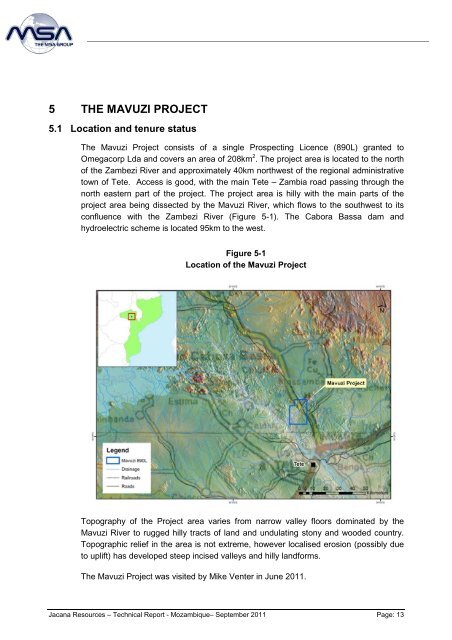
The Mavuzi Project consists of a single Prospecting Licence (890L) granted to<br />
Omegacorp Lda and covers an area of 208km 2 . The project area is located to the north<br />
of the Zambezi River and approximately 40km northwest of the regional administrative<br />
town of Tete. Access is good, with the main Tete – Zambia road passing through the<br />
north eastern part of the project. The project area is hilly with the main parts of the<br />
project area being dissected by the Mavuzi River, which flows to the southwest to its<br />
confluence with the Zambezi River (Figure 5-1). The Cabora Bassa dam and<br />
hydroelectric scheme is located 95km to the west.<br />
Figure 5-1<br />
Location of the Mavuzi Project<br />
Topography of the Project area varies from narrow valley floors dominated by the<br />
Mavuzi River to rugged hilly tracts of land and undulating stony and wooded country.<br />
Topographic relief in the area is not extreme, however localised erosion (possibly due<br />
to uplift) has developed steep incised valleys and hilly landforms.<br />
The Mavuzi Project was visited by Mike Venter in June 2011.<br />
Jacana <strong>Resources</strong> – Technical <strong>Report</strong> - <strong>Mozambique</strong>– September 2011 Page: 13