Notice of Preparation - Visalia General Plan Update
Notice of Preparation - Visalia General Plan Update
Notice of Preparation - Visalia General Plan Update

You also want an ePaper? Increase the reach of your titles
YUMPU automatically turns print PDFs into web optimized ePapers that Google loves.
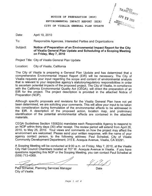
NOTICE OF PREPARATION (NOP)<br />
ENVIRONMENTAL IMPACT REPORT (EIR)<br />
CITY OF VISALIA GENERAL PLAN UPDATE<br />
Date: April 16, 2010<br />
To:<br />
Subject:<br />
Responsible Agencies, Interested Parties and Organizations<br />
<strong>Notice</strong> <strong>of</strong> <strong>Preparation</strong> <strong>of</strong> an Environmental Impact Report for the City<br />
<strong>of</strong> <strong>Visalia</strong> <strong>General</strong> <strong>Plan</strong> <strong>Update</strong> and Scheduling <strong>of</strong> a Scoping Meeting<br />
on Friday, May 7, 2010<br />
Project Title: City <strong>of</strong> <strong>Visalia</strong> <strong>General</strong> <strong>Plan</strong> <strong>Update</strong><br />
Location:<br />
City <strong>of</strong> <strong>Visalia</strong>, California<br />
The City <strong>of</strong> <strong>Visalia</strong> is preparing a <strong>General</strong> <strong>Plan</strong> <strong>Update</strong> and has determined that a<br />
comprehensive Environmental Impact Report (EIR) will be necessary. The City <strong>of</strong><br />
<strong>Visalia</strong> requests your input regarding the scope and content <strong>of</strong> environmental analysis<br />
that is relevant to your respective agency’s statutory/regulatory responsibilities in order<br />
to ascertain potential impacts <strong>of</strong> the proposed project. The City <strong>of</strong> <strong>Visalia</strong>, in compliance<br />
with the California Environmental Quality Act (CEQA), will direct the preparation <strong>of</strong> an<br />
EIR for the project. The project description is provided in the attached <strong>Notice</strong> <strong>of</strong><br />
<strong>Preparation</strong> (NOP).<br />
Although specific proposals and revisions for the <strong>Visalia</strong> <strong>General</strong> <strong>Plan</strong> have not yet<br />
been determined, we are soliciting your comments. This will allow your input to be taken<br />
into consideration during formulation <strong>of</strong> the environmental effects to be addressed in<br />
the EIR. A description <strong>of</strong> the proposed action, location map, and preliminary<br />
identification <strong>of</strong> the potential environmental effects are contained in the attached<br />
materials.<br />
CEQA Guidelines Section 15082(b) mandates each Responsible Agency to respond to<br />
an NOP within thirty days (30) after receipt. The review period will extend from April 19,<br />
2010, to May 18, 2010. Your views and comments on how the project may affect the<br />
environment are welcomed. Please send your written response, with the name <strong>of</strong> your<br />
agency contact person, to the following address: Paul Scheibel, City <strong>of</strong> <strong>Visalia</strong><br />
Community Development Department; 315 E. Acequia Avenue, <strong>Visalia</strong>, CA 93291.<br />
A Scoping Meeting will be conducted at 9:00 a.m. on Friday, May 7, 2010, at the <strong>Visalia</strong><br />
City Hall Council Chambers located at 707 W. Acequia Avenue in <strong>Visalia</strong>. If you have<br />
questions regarding this NOP or the Scoping Meeting, you can contact Paul Scheibel at<br />
(559) 713-4369.<br />
Paul Scheibel, <strong>Plan</strong>ning Services Manager<br />
City <strong>of</strong> <strong>Visalia</strong><br />
Date
NOTICE OF PREPARATION (NOP)<br />
ENVIRONMENTAL IMPACT REPORT (EIR)<br />
CITY OF VISALIA GENERAL PLAN UPDATE<br />
1. PROJECT TITLE:<br />
City <strong>of</strong> <strong>Visalia</strong> <strong>General</strong> <strong>Plan</strong> <strong>Update</strong><br />
2. LEAD AGENCY NAME AND ADDRESS:<br />
City <strong>of</strong> <strong>Visalia</strong><br />
Community Development Department<br />
315 E. Acequia Avenue<br />
<strong>Visalia</strong>, CA 93291<br />
3. CONTACT PERSON AND PHONE NUMBER:<br />
Paul Scheibel<br />
<strong>Plan</strong>ning Services Manager<br />
(559) 713-4369<br />
pscheibel@ci.visalia.ca.us<br />
4. PROJECT LOCATION:<br />
The City <strong>of</strong> <strong>Visalia</strong>, located in the central San Joaquin Valley, covers an area <strong>of</strong><br />
approximately 36 square miles. The City is situated in northwestern Tulare<br />
County, north <strong>of</strong> the City <strong>of</strong> Tulare and west <strong>of</strong> the City <strong>of</strong> Farmersville (Figure<br />
1). The City <strong>of</strong> Hanford, in Kings County, lies 12 miles to the west. With a 2009<br />
population <strong>of</strong> 123,670, <strong>Visalia</strong> is the largest city in Tulare County.<br />
Highway 198 passes east-west through the center <strong>of</strong> the City, while Highway 99<br />
runs north-south two miles from the western edge <strong>of</strong> the City. Highway 63<br />
passes north-south through the center <strong>of</strong> the City. The City is also served by<br />
transit, including the <strong>Visalia</strong> City Coach (VCC) and Tulare County Area Transit<br />
(TCAT). Amtrak connects to <strong>Visalia</strong> via a bus service from the train station in<br />
Hanford. Additionally, the City is served by the <strong>Visalia</strong> Municipal Airport, which is<br />
located at the City’s western edge, along Highway 99.<br />
The Proposed <strong>Plan</strong>ning Area comprises all land within the City limits as well as<br />
neighboring unincorporated land, excluding the community <strong>of</strong> Goshen (Figure<br />
2). The existing City limits include residential, commercial, and industrial<br />
developments; as well as public facilities including parks, schools, public<br />
utilities, the College <strong>of</strong> the Sequoias campus; and private institutions like Fresno<br />
Pacific University.
5. PROJECT SPONSOR'S NAME AND ADDRESS:<br />
City <strong>of</strong> <strong>Visalia</strong><br />
Community Development Department<br />
315 E. Acequia Avenue<br />
<strong>Visalia</strong>, CA 93291<br />
6. DESCRIPTION OF PROJECT:<br />
The current City <strong>of</strong> <strong>Visalia</strong> <strong>General</strong> <strong>Plan</strong> was last comprehensively updated in<br />
1991. Although some <strong>of</strong> the policies in this document are still relevant, much<br />
has changed since its adoption. Since 2000, the City’s population increased by<br />
35 percent, while employment increased by 12 percent. While unemployment<br />
has risen since the economic downturn <strong>of</strong> 2008 and 2009, the Tulare County<br />
Association <strong>of</strong> Governments (TCAG) projections that the City will add some<br />
25,000 new jobs by 2030. TCAG also expects population to increase to a<br />
projected 207,600 by 2030—an increase <strong>of</strong> 46 percent over the next 20 years.<br />
The <strong>General</strong> <strong>Plan</strong> <strong>Update</strong> provides the community with an opportunity to clarify<br />
its vision for future development patterns, transportation systems, economic<br />
development opportunities, and sustainable growth. The <strong>General</strong> <strong>Plan</strong> will have<br />
a horizon year <strong>of</strong> 2030.<br />
The <strong>General</strong> <strong>Plan</strong> <strong>Update</strong> will likely address the following topics, which will be<br />
combined into an integrated <strong>Plan</strong>:<br />
Land Use;<br />
Circulation;<br />
City Design;<br />
Open Space, Parks, and Recreation;<br />
Noise;<br />
Safety;<br />
Community Facilities and Public Services; and<br />
Conservation, Air Quality, and Greenhouse Gas Emissions.<br />
In order to meet the deadlines <strong>of</strong> California’s Department <strong>of</strong> Housing and<br />
Community Development (HCD), the update <strong>of</strong> the City’s Housing Element,<br />
another required component <strong>of</strong> the <strong>General</strong> <strong>Plan</strong>, was completed in 2009. Upon<br />
completion <strong>of</strong> the <strong>General</strong> <strong>Plan</strong> <strong>Update</strong>, the two documents will be reviewed for<br />
internal consistency.<br />
Work on the <strong>General</strong> <strong>Plan</strong> <strong>Update</strong> is in progress. The scope includes a review<br />
<strong>of</strong> background material and preparation <strong>of</strong> an initial working paper: Existing<br />
Conditions and Key Issues Report. This report will contain a description and<br />
series <strong>of</strong> maps documenting existing land uses, public facilities, and<br />
environmental conditions within the City <strong>of</strong> <strong>Visalia</strong>. Coinciding with the
preparation <strong>of</strong> the existing conditions paper, initial outreach in the form <strong>of</strong><br />
stakeholder interviews and community workshops will be held in later spring and<br />
summer <strong>of</strong> 2010. This outreach will continue and also contribute to the<br />
environmental analysis for the project.<br />
The next step <strong>of</strong> the <strong>General</strong> <strong>Plan</strong> <strong>Update</strong> will include development <strong>of</strong> potential<br />
land use and transportation alternatives through direct participation with the<br />
community and <strong>General</strong> <strong>Plan</strong> <strong>Update</strong> Review Committee (GPURC). The<br />
alternatives will focus on changes at identified locations within the City. An<br />
additional community workshop will be held to further identify and refine<br />
concepts for the alternatives. The resulting alternative concepts will be<br />
presented to the GPURC for further refinement, followed by a discussion <strong>of</strong> the<br />
relative advantages and disadvantages <strong>of</strong> each with City decision-makers.<br />
Following this process, a Preferred <strong>Plan</strong> will be prepared and reviewed by the<br />
community and GPURC prior to presentation to City decision-makers. Based on<br />
the Preferred <strong>Plan</strong>, the <strong>General</strong> <strong>Plan</strong> <strong>Update</strong> will be drafted.<br />
A final community workshop will ensure that the community’s needs have been<br />
addressed in the proposed Preferred <strong>Plan</strong>. A series <strong>of</strong> public hearings will then<br />
allow City decision-makers to consider the proposed <strong>Plan</strong>.<br />
The entire scope <strong>of</strong> work for the <strong>General</strong> <strong>Plan</strong> <strong>Update</strong> and EIR is attached as<br />
Appendix A.<br />
7. EIR<br />
This NOP is a required publication at the outset <strong>of</strong> the EIR process.<br />
The EIR will provide a programmatic environmental assessment <strong>of</strong> the potential<br />
consequences <strong>of</strong> the proposed <strong>General</strong> <strong>Plan</strong> <strong>Update</strong>. It will discuss how<br />
<strong>General</strong> <strong>Plan</strong> policies could potentially affect the environment, identify any<br />
significant impacts, and recommend measures to mitigate those impacts. The<br />
EIR will also consider the potential environmental impacts <strong>of</strong> alternatives, and<br />
identify an environmentally superior alternative. Subsequent environmental<br />
review will be conducted for major development projects, public works and<br />
infrastructure improvements to evaluate site-specific issues.
8. SURROUNDING LAND USES AND SETTING:<br />
<strong>Visalia</strong>’s <strong>Plan</strong>ning Area boundaries include the entire city limits, Sphere <strong>of</strong><br />
Influence, and some additional unincorprated land that borders the City (Figure<br />
2). The unincorporated community <strong>of</strong> Goshen lies to the northwest, and the City<br />
<strong>of</strong> Farmersville lies to the east. Most <strong>of</strong> the remaining land uses surrounding the<br />
City are agricultural in nature. Several creeks, rivers, and canals run through<br />
and adjacent to the City, including the St. John’s River, which forms the<br />
northeast border <strong>of</strong> the City. Mill, Packwood, and Persian creeks run east-west<br />
through the City.<br />
9. OTHER PUBLIC AGENCIES WHOSE APPROVAL IS REQUIRED:<br />
No other public agency is required to approve the <strong>Visalia</strong> <strong>General</strong> <strong>Plan</strong> <strong>Update</strong>.<br />
However, development under the <strong>General</strong> <strong>Plan</strong> may require approval <strong>of</strong> State,<br />
federal and responsible trustee agencies that may rely on this EIR for<br />
information relative to their area <strong>of</strong> expertise and jurisdiction.<br />
10 POTENTIAL ENVIRONMENTAL IMPACTS TO BE CONSIDERED:<br />
Preliminary topics for the EIR include:<br />
Land Use (including jobs and housing);<br />
Aesthetics and Visual Resources;<br />
Open Space and Recreation;<br />
Biological Resources;<br />
Cultural Resources;<br />
Transportation and Traffic;<br />
Air Quality;<br />
Noise and Vibration;<br />
Geology, Soils, and Seismicity;<br />
Hydrology and Flooding;<br />
Public Services and Utilities;<br />
Energy;<br />
Climate Change; and<br />
Hazardous Materials and Toxics.<br />
In addition to the potential environmental effects listed above, the EIR will<br />
evaluate potential cumulative effects and potential growth-inducing impacts <strong>of</strong><br />
the proposed <strong>Visalia</strong> <strong>General</strong> <strong>Plan</strong> <strong>Update</strong> as well as alternatives to the
proposed <strong>General</strong> <strong>Plan</strong> <strong>Update</strong>. The No Project alternative will evaluate the<br />
impacts resulting from continued implementation <strong>of</strong> existing plans, policies, and<br />
regulations which govern the City. As appropriate, other alternatives that would<br />
avoid or lessen environmental effects related to the proposed <strong>Visalia</strong> <strong>General</strong><br />
<strong>Plan</strong> <strong>Update</strong> will be discussed. The draft EIR will also recommend measures to<br />
mitigate any significant environmental impacts.
UV 145 UV 63 UV 201 UV 190<br />
UV 168<br />
Sequoia<br />
National Forest<br />
UV 180 UV 65<br />
Fresno<br />
Sanger<br />
Kings Canyon<br />
National Park<br />
Orange Cove<br />
Parlier<br />
UV 69<br />
Reedley--Dinuba<br />
UV 43<br />
Orosi<br />
Selma<br />
UV 63<br />
UV 145<br />
UV 41 UV 201<br />
F R E S N O<br />
UV<br />
UV 198<br />
41<br />
UV 33 UV<br />
UV 137<br />
137<br />
Lake<br />
Woodlake<br />
UV UV 63<br />
Kaweah<br />
216<br />
Ivanhoe<br />
<strong>Visalia</strong><br />
Hanford<br />
UV UV 198<br />
43<br />
Lemoore<br />
Farmersville<br />
UV 269<br />
Lemoore Station<br />
UV 198 Lindsay<br />
Tulare<br />
UV 41 Corcoran<br />
Porterville<br />
UV 43<br />
UV UV 99<br />
33<br />
K I N G S<br />
Pixley<br />
Terra Bella<br />
Kings River<br />
§¨¦ 5 UV 99 UV 180 UV 198 UV 190<br />
Tule River<br />
Kaweah River<br />
Tule River<br />
Dry Creek<br />
T U L A R E<br />
Lake Success<br />
Sequoia National Park<br />
Sequoia National Forest<br />
i<br />
Kern R<br />
ver<br />
Inyo<br />
National<br />
Forest<br />
UV 41<br />
Earlimart<br />
UV 65<br />
Study Boundary<br />
Sphere <strong>of</strong> Influence<br />
Urbanized Area<br />
County Line<br />
Freeway<br />
Highway<br />
Major Road<br />
Figure 1:<br />
Regional Setting<br />
Source: Sphere <strong>of</strong> Influence, City <strong>of</strong> <strong>Visalia</strong>,<br />
2010; Digital Elevation Model, United States<br />
Geological Survey, 2009; National Forest and<br />
Park, United States Geological Survey, 2006;<br />
Hydrology, Metropolitan Transportation<br />
Commission, 2008; Map base, TeleAtlas North<br />
America, Inc., 2008.<br />
0 2.5 5 10<br />
Miles
ROAD 60<br />
ROAD 64<br />
ROAD 68<br />
ROAD 80<br />
ALTA AVE<br />
SHIRK RD<br />
ROAD 92<br />
CHINOWTH ST<br />
ROAD 108<br />
ROAD 108<br />
ROAD 112<br />
HALL ST<br />
JACOB ST<br />
WILLIS ST<br />
SANTA FE AVE<br />
CAIN ST<br />
LOVER LANE LN<br />
ROAD 144<br />
ROAD 158<br />
Figure 2<br />
Study Area<br />
DIAGONAL 60 RD<br />
AVENUE 328<br />
ROAD 156<br />
St. Joh n<br />
's River<br />
ROAD 132<br />
UV 99 UV 63 UV 216<br />
AVENUE 320<br />
AVENUE 313<br />
CAMP-RIGGIN AVE<br />
RIGGIN AVE<br />
RIGGIN AVE<br />
S<br />
T. JO HN'S PKWY<br />
MCAULIFF RD<br />
DINUBA BLVD<br />
MOONEY BLVD<br />
GIDDINGS ST<br />
DEMAREE ST<br />
AKERS RD<br />
DOE AVE<br />
IVANHOE DR<br />
HURLEY AVE<br />
MINERAL KING AVE<br />
NOBLE AVE<br />
MIL L<br />
C REEK DR<br />
MAIN ST<br />
3RD AVE<br />
2ND AVE<br />
MURRAY AVE<br />
CENTER AVE<br />
ACEQUIA AVE<br />
COURT ST<br />
1ST AVE<br />
BEN MADDOX WAY<br />
CAMP DR<br />
VINE AVE<br />
COURT ST<br />
PLAZA ST<br />
GOSHEN AVE<br />
GOSHEN AVE<br />
HOUSTON AVE<br />
MAIN ST<br />
BURKE ST<br />
E HOUSTON AVE<br />
GOSHEN AVE<br />
UV 198 UV 198<br />
WATSON ST<br />
LOCUST ST<br />
3RD AVE<br />
MAIN ST<br />
MINERAL KING AVE<br />
NOBLE AVE<br />
MINERAL KING AVE<br />
NOBLE AVE<br />
COUNT<br />
TULARE AVE<br />
TULARE AVE<br />
MCAULIFF ST<br />
SANTA FE AVE<br />
MOONEY BLVD<br />
GIDDINGS ST<br />
LOVERS LN<br />
CONYER ST<br />
COURT ST<br />
Y C ENTER ST<br />
WALNUT AVE<br />
WALNUT AVE<br />
MARINETTE AVE<br />
LINWOOD ST<br />
DEMAREE ST<br />
ROEBEN ST<br />
AKERS RD<br />
WHITENDALE AVE<br />
BEN MA DD O X WAY<br />
K AVE<br />
COUNTY CENTER ST<br />
AVENUE 280<br />
UV 198 AVENUE 264<br />
CALDWELL AVE<br />
AVENUE 280<br />
CALDWELL AVE<br />
VISALIA RD AVE<br />
UV 63<br />
Study Boundary<br />
Sphere <strong>of</strong> Influence<br />
City Limits<br />
Urban and Built-Up Land<br />
UV 99<br />
AVENUE 264<br />
ROAD 92B<br />
AVENUE 260<br />
0 0.25 0.5 1<br />
Miles<br />
Source: Urban areas, California Department <strong>of</strong> Conservation, 2009;<br />
Map base, City <strong>of</strong> <strong>Visalia</strong>, County <strong>of</strong> Tulare and Dyett and Bhatia, 2010.
Proposal for the City <strong>of</strong> <strong>Visalia</strong><br />
<strong>General</strong> <strong>Plan</strong> <strong>Update</strong> and EIR<br />
2 Scope <strong>of</strong> Work<br />
2.1 Phases <strong>of</strong> Work and Schedule<br />
PHASES<br />
Our approach to the <strong>Visalia</strong> <strong>General</strong> <strong>Plan</strong> <strong>Update</strong> and the Environmental Impact Report (EIR)<br />
work program envisions the project to be broken down into three phases, each <strong>of</strong> which involves<br />
several major tasks. This section provides an overview and a detailed scope <strong>of</strong> work. The<br />
total timeframes for each phase are presented, along with the amount <strong>of</strong> time that will be spent<br />
on each task. The timeframes for the tasks overlap, as shown on the graphic schedule that follows.<br />
The total estimated time frame for the <strong>General</strong> <strong>Plan</strong> and EIR is three years.<br />
Phase I: Visioning, Outreach, and Background Studies – 10 Months Total<br />
Task: Reconnaissance, Organization, and Technical Work. (3 Months) A kick-<strong>of</strong>f meeting<br />
will be held with City staff and the team, which includes a field tour. The public participation<br />
program will be finalized. Background information needs will be determined,<br />
plan product formats, including computer-mapping formats, will be established, and<br />
the available land use information will be analyzed. During this Phase, we will also establish<br />
a <strong>General</strong> <strong>Plan</strong> update website.<br />
Task 2: Visioning and Issue Identification. (5 Months) Key issues would be identified<br />
through field reconnaissance and review <strong>of</strong> planning documents, stakeholder interviews,<br />
Review Committee meetings, decision-maker meetings, a community survey, as<br />
well as a community workshop.<br />
Task 3: Existing Conditions and Key Issues Report. (7 Months) An assessment <strong>of</strong> the existing<br />
conditions, trends, and key issues—physical, economic, and environmental—will be<br />
undertaken. This assessment will provide the springboard for the plan alternatives, as<br />
well as the basis for policies in the <strong>General</strong> <strong>Plan</strong>, and the setting for the <strong>General</strong> <strong>Plan</strong><br />
EIR. A baseline transportation analysis will be included. A report will be prepared in<br />
the form <strong>of</strong> a “map atlas,” emphasizing graphics and maps. This document will serve as<br />
a repository <strong>of</strong> all data collected and analyzed, so that the planning process can be delayed<br />
if necessary until additional funding is available.<br />
Phase II: Choices – 13 Months<br />
Task 4: Alternatives and Evaluation. (7 Months) Dyett & Bhatia will develop three alternative<br />
scenarios for future development, arranged in a workbook. These alternatives will<br />
focus on key decisions related to the areas <strong>of</strong> future growth and areas with infill devel-<br />
2-1
opment opportunities. The alternatives will be evaluated with the community, Review<br />
Committee, <strong>Plan</strong>ning Commission, and City Council. The evaluation will consider<br />
sustainability and greenhouse gas emissions; environmental and agricultural land impacts;<br />
transportation access and impacts; infrastructure costs; and other critical factors.<br />
Task 5: Preferred <strong>Plan</strong>, Policy Framework, and Phasing <strong>Plan</strong>. (6 Months) Based on feedback<br />
from the community and decision-makers, a preferred plan will be prepared,<br />
along with key policies that form the core <strong>of</strong> the <strong>General</strong> <strong>Plan</strong>. Potential policies related<br />
to green building, recycled water, and other sustainable development issues will be introduced.<br />
A table <strong>of</strong> existing <strong>General</strong> <strong>Plan</strong> policies will identify policies to be retained,<br />
revised, or deleted. A preliminary phasing plan will also be drafted and discussed. This<br />
document will summarize the preferred plan and key policy choices, so that the community<br />
consensus is memorialized if the planning process needs to be delayed due to<br />
funding.<br />
Phase III: Draft <strong>General</strong> <strong>Plan</strong> and EIR – 13 Months<br />
Task 6: Draft <strong>General</strong> <strong>Plan</strong>. (6.5 Months) We propose to include the following elements.<br />
This would be refined based on input from City staff, the community, and decisionmakers:<br />
• State-mandated elements: Land Use; Circulation; Open Space, Parks, and<br />
Recreation, Noise; Safety; and Conservation/Air Quality.<br />
• Community Facilities and Public Services: An additional element is proposed<br />
to cover community facilities and public services. Public services include: schools,<br />
infrastructure (stormwater management, wastewater systems, and water supply and<br />
distribution); solid waste management; and police and fire services. Community facilities<br />
include libraries, civic and cultural facilities, and historic preservation resources.<br />
• City Design Element: This element covers street design, scenic highways, urban<br />
design, gateways, neighborhood design character, and other urban design issues.<br />
• Implementation Program: This outlines the major <strong>General</strong> <strong>Plan</strong> initiatives to be<br />
accomplished over the next 20 years and how they can be carried out over time.<br />
• Sustainability. We propose that sustainability policies will be integrated<br />
throughout the plan, since best practices for sustainability apply to all the different<br />
<strong>General</strong> <strong>Plan</strong> elements. However a separate Sustainability Element could be prepared.<br />
The plan will include both guiding policies and implementation policies in each chapter.<br />
This will be laid out in an easy-to-read format, with rich use <strong>of</strong> photographs, drawings,<br />
and three-dimensional visualization. It will be provided to the City in a format so<br />
as to be easily accessible on the web.<br />
Task 7: Draft and Final EIR. (10 Months) Impact assessment will be conducted parallel to<br />
<strong>General</strong> <strong>Plan</strong> preparation, so that mitigation can be built into the <strong>General</strong> <strong>Plan</strong>, resulting<br />
in a self-mitigating <strong>Plan</strong>.<br />
2-2
Proposal for the City <strong>of</strong> <strong>Visalia</strong><br />
<strong>General</strong> <strong>Plan</strong> <strong>Update</strong> and EIR<br />
Task 8: Community Review and Adoption. (7 Months) The Draft <strong>General</strong> <strong>Plan</strong> and Draft<br />
EIR will be circulated for review and comment, and discussed at public hearings. Final<br />
versions will be prepared based on final direction from the City Council.<br />
2-3
MEETINGS<br />
The following meetings are anticipated in our scope <strong>of</strong> work and presented in the work program<br />
after their corresponding task. They also are shown graphically on the Project Schedule in<br />
Section 2.3.<br />
Public Meetings in the Scope <strong>of</strong> Work<br />
City Council/<br />
<strong>Plan</strong>ning<br />
Commission<br />
Task 1: Reconnaissance,<br />
Organization, and Technical<br />
Work<br />
Task 2: Issue Identification and<br />
Visioning 1<br />
Task 3:<br />
Community/<br />
Neighborhood<br />
Workshops<br />
1 (with <strong>General</strong><br />
<strong>Plan</strong> Review<br />
Committee)<br />
<strong>General</strong> <strong>Plan</strong><br />
Review<br />
Committee<br />
Existing Conditions and Key<br />
Issues Assessment 1 1<br />
Stakeholder<br />
Interview<br />
Sessions<br />
15<br />
Task 4:<br />
Task 5:<br />
<strong>Plan</strong>ning Alternatives<br />
3 (includes 2<br />
1<br />
special<br />
community<br />
meetings)<br />
2 2-3<br />
Preferred <strong>Plan</strong> and Key<br />
Policies Formulation 1 1 4<br />
Task 6:<br />
Draft <strong>General</strong> <strong>Plan</strong><br />
1 2<br />
Task 7:<br />
Task 8:<br />
Draft Environmental Impact<br />
Report 1<br />
Community Review and<br />
Adoption 4<br />
Total <strong>General</strong> <strong>Plan</strong> / EIR 8 6 6 22<br />
2-4
Proposal for the City <strong>of</strong> <strong>Visalia</strong><br />
<strong>General</strong> <strong>Plan</strong> <strong>Update</strong> and EIR<br />
PRODUCTS<br />
The following products are anticipated in our scope <strong>of</strong> work, presented in the work program<br />
after their corresponding task, and shown graphically on the Project Schedule in Section 2.3.<br />
Coordination/Outreach Materials<br />
Detailed Work Program & Project Schedule<br />
Project Website<br />
Community Outreach Summary Report<br />
Newsletter #1: Project Introduction<br />
Newsletter #2: Opportunities & Challenges<br />
Newsletter #3: Alternative <strong>Plan</strong>s<br />
Newsletter #4: Draft Preferred <strong>Plan</strong><br />
Newsletter #5: <strong>General</strong> <strong>Plan</strong> Summary<br />
Community Survey<br />
Workbooks/Reports<br />
Draft Vision/Guiding Principles Memorandum<br />
Existing <strong>General</strong> <strong>Plan</strong> Policy Matrix; Summary<br />
Report<br />
Existing Conditions, Opportunities and<br />
Challenges Workbook with Map Atlas<br />
(Draft and Final)<br />
Smart Growth Development Examples<br />
Booklet<br />
Best Practices Memorandum<br />
Sustainability Indicators Memorandum<br />
Alternative <strong>Plan</strong>s Workbook<br />
Travel Demand Forecast/Alternatives<br />
Analysis Working Paper<br />
Fiscal Analysis Technical Memorandum<br />
(Optional)<br />
Draft Preferred <strong>Plan</strong>, Policy Framework,<br />
and Phasing Alternatives Report<br />
Infrastructure Analysis Memorandum<br />
Sustainable Development Policies Memorandum<br />
<strong>General</strong> <strong>Plan</strong> Documents<br />
<strong>General</strong> <strong>Plan</strong> Outline<br />
Administrative Draft <strong>General</strong> <strong>Plan</strong><br />
Public Hearing Draft <strong>General</strong> <strong>Plan</strong><br />
<strong>General</strong> <strong>Plan</strong> Executive Summary<br />
Adopted <strong>General</strong> <strong>Plan</strong> (with “screen-check”<br />
review copy)<br />
GIS Layers for Land Use, Existing Land<br />
Use, and other key topics<br />
CEQA Documents<br />
<strong>Notice</strong> <strong>of</strong> <strong>Preparation</strong><br />
<strong>Notice</strong> <strong>of</strong> Completion<br />
<strong>Notice</strong> <strong>of</strong> Determination<br />
Administrative Draft EIR<br />
Draft EIR<br />
Administrative Final EIR: Addendum –<br />
Response to Comments<br />
Final EIR: Addendum – Response to<br />
Comments<br />
Statement <strong>of</strong> Overriding Considerations (if<br />
necessary)<br />
Mitigation Monitoring and Reporting Program<br />
(if necessary)<br />
Implementation Documents<br />
Implementation Program<br />
2-5
2.2 Detailed Scope <strong>of</strong> Work<br />
This section outlines our proposed work program for all phases <strong>of</strong> the <strong>Visalia</strong> <strong>General</strong> <strong>Plan</strong> <strong>Update</strong>.<br />
The program is organized into eight tasks, from project initiation to publishing the final<br />
<strong>General</strong> <strong>Plan</strong> and EIR documents. The sequence <strong>of</strong> work products, community meetings and<br />
City Council/<strong>Plan</strong>ning Commission workshops are graphically illustrated in Section 2.3: Phases<br />
and Schedule.<br />
The task-by-task descriptions that follow present our approach to data collection, alternatives<br />
analysis, policy formulation and preparation <strong>of</strong> the documents. Each task description includes a<br />
purpose statement at the beginning.<br />
Initials in parentheses following the sub-section heading identify the lead firm for each subtask:<br />
• D&B: Dyett & Bhatia, Urban and Regional <strong>Plan</strong>ners<br />
• EPS: Economic & <strong>Plan</strong>ning Systems, Economics and Public Finance Consultants<br />
• UG: Urban Green, Sustainability Consultants<br />
• J&S: Jones & Stokes, Environmental Consultants<br />
• OM: Omni-Means, Transportation Engineers & <strong>Plan</strong>ners<br />
• PP: Provost & Pritchard, Civil Engineers - Infrastructure Consultants<br />
• MWR: Mountain West Research, Survey Specialists<br />
TASK 1: RECONNAISSANCE, ORGANIZATION, AND TECHNICAL<br />
WORK<br />
The objective <strong>of</strong> this first task will be to develop a detailed Public Participation Program, as well to<br />
conduct a series <strong>of</strong> introductory and organizational tasks. Background information needs will be<br />
determined, plan product formats, including computer-mapping formats, will be established, and<br />
the available land use information will be analyzed. During this Phase, we will also establish a<br />
<strong>General</strong> <strong>Plan</strong> update website.<br />
A. Kick-<strong>of</strong>f Meeting and Field Tour with City Staff (D&B, OM, J&S, EPS, PP). The consultants<br />
will meet with members <strong>of</strong> the City <strong>Plan</strong>ning Department staff for a half-day to discuss<br />
their ideas and aspirations for the project. At these meetings data sources will be identified,<br />
roles and responsibilities will be clarified, communication protocols will be established,<br />
and work program modifications will be discussed. A field tour <strong>of</strong> the City to examine<br />
key issues will be part <strong>of</strong> the kick-<strong>of</strong>f meeting.<br />
B. Background Information (D&B). Existing information needed for the <strong>General</strong> <strong>Plan</strong> will be<br />
gathered, including: water, sewer, transportation and other facility plans, existing land use,<br />
and details on the status <strong>of</strong> proposed and approved development projects. During the kick-<br />
2-6
Proposal for the City <strong>of</strong> <strong>Visalia</strong><br />
<strong>General</strong> <strong>Plan</strong> <strong>Update</strong> and EIR<br />
<strong>of</strong>f meeting, we will coordinate with <strong>Plan</strong>ning Department and other City staff to provide<br />
the consultant team with an overview <strong>of</strong> existing plans and program, pipeline development,<br />
major opportunities, and key issues.<br />
C. Gather Information from Other Public Agencies (D&B). Representatives from neighboring<br />
jurisdictions and Tulare County will be contacted in order to coordinate with local and<br />
regional planning efforts. Other relevant regional agencies that regulate issues or produce<br />
plans will be contacted.<br />
D. Obtain City/County Base Maps, Current Digital Orthophotography, and Compile GIS<br />
Database (D&B). Using data available from the City, Tulare County, and our fieldwork, we<br />
will prepare a computerized base map for the display and analysis <strong>of</strong> <strong>Plan</strong>ning Area land<br />
data. All GIS information and database development will be coordinated to be compatible<br />
with ArcGIS and the City’s current mapping efforts. The database will include georeferenced<br />
aerials for a composite database for the <strong>Plan</strong>ning Area. All streets will be included,<br />
and parcel lines will be shown on some <strong>of</strong> the published maps.<br />
E. Land Use and Vacant Parcel Survey (D&B). The City currently does not have a complete<br />
GIS database <strong>of</strong> existing land use. Obtaining existing land use and zoning data layers will be<br />
essential for looking at infill and reuse opportunities. A land use data layer would be created<br />
from existing data sources, such GIS data for Tulare County and third party sources. Focused<br />
windshield surveys would be used to complement the land use and assessor’s parcel<br />
data to identify opportunity sites. Significant vacant parcels and parcels with redevelopment<br />
potential would be surveyed in more detail and identified in the Map Atlas, described below;<br />
they also will be the foundation for the <strong>General</strong> <strong>Plan</strong> Housing Element <strong>Update</strong>. Information<br />
from the East Downtown Expansion Area plan will be incorporated.<br />
F. Existing Transportation Conditions (OM).<br />
• Traffic Counts: Existing daily and peak hour traffic counts will be obtained from the City,<br />
Caltrans and recent traffic studies and EIRs. Under this task it is anticipated that up to 25<br />
AM and PM peak hour and 25 daily counts be newly conducted. Should additional daily or<br />
peak hour counts be required as determined by City/Caltrans staff and/or the TAC, OMNI-<br />
MEANS will provide a budget and obtain additional authorization.<br />
• Transportation Corridor Data: Available transportation corridor data will be obtained from<br />
all available sources, including the City, TCAG and Caltrans files. This information would<br />
include:<br />
• Right-<strong>of</strong>-way widths<br />
• Pavement width<br />
• Travel lanes<br />
• Travel speed (85% or posted speed)<br />
• Grades<br />
• <strong>Plan</strong>ned improvement projects<br />
2-7
G. Demographic Analysis and Trends. (D&B) An analysis <strong>of</strong> census data and other more<br />
recent data sources will be conducted to study population growth and demographic trends<br />
in <strong>Visalia</strong>.<br />
H. Establish Project Website (D&B). D&B will provide to City staff a complete design <strong>of</strong> the<br />
project website. Interim designs will be reviewed with staff before the site is finalized. This<br />
site will be hosted on the City’s website or as a stand-alone site. The Scope <strong>of</strong> Work, Schedule<br />
Existing Conditions and Key Issues Report (see Task 3), upcoming participation opportunities,<br />
and other material will be placed on the project website.<br />
Meetings: Kick-<strong>of</strong>f & Issues Meeting with City Staff<br />
Products: Final Project Work Program & Schedule<br />
Project Website<br />
Electronic Base Map for the <strong>General</strong> <strong>Plan</strong><br />
Traffic Counts<br />
TASK 2: COMMUNITY VISIONING AND ISSUE IDENTIFICATION<br />
The objective <strong>of</strong> this task is to identify and understand community concerns and to establish a<br />
coordinated and realistic direction for the future founded on a community-based strategic vision.<br />
This task is intended not only to provide a more complete picture <strong>of</strong> the issues and opportunities<br />
facing the City <strong>of</strong> <strong>Visalia</strong>, but also to build public support and ‘buy-in’ into the <strong>General</strong><br />
<strong>Plan</strong> <strong>Update</strong> process.<br />
A. Kick<strong>of</strong>f Workshop with <strong>General</strong> <strong>Plan</strong> Review Committee and Public. (D&B) Conduct a<br />
workshop with members <strong>of</strong> the Review Committee and the public to discuss their ideas and<br />
aspirations for the <strong>General</strong> <strong>Plan</strong>. The meeting will have three principal objectives:<br />
2-8<br />
• Discuss what people like about <strong>Visalia</strong> and want to preserve.<br />
• Discuss key concerns and issues that should be covered in the <strong>General</strong> <strong>Plan</strong> process.<br />
• Discuss the future vision <strong>of</strong> <strong>Visalia</strong> in 2030 and key priorities to accomplish.<br />
The consultant team will prepare materials and conduct the workshop (we expect that<br />
city staff will be available for tabletop facilitation at a few tables). The meeting will be<br />
designed as a community event, to facilitate the participation <strong>of</strong> a wide diversity <strong>of</strong> residents,<br />
business people, and other key stakeholders. D&B will prepare all materials for<br />
the workshop, and summarize findings. We would work with City staff, stakeholders,<br />
Review Committee members, and possibly the City Council to extend personal invitations<br />
to community members, in order to encourage attendance.<br />
We would meet with the <strong>General</strong> <strong>Plan</strong> Review Committee immediately before the<br />
community workshop to do introductions, discuss their important role in the project,<br />
and discuss logistics and scheduling.<br />
B. Existing <strong>General</strong> <strong>Plan</strong> Review. (D&B) During this task, D&B will also carefully evaluate<br />
the current <strong>General</strong> <strong>Plan</strong> using a matrix <strong>of</strong> policies and discussions with City staff to determine<br />
the overall effectiveness and areas that need improvement. The existing plan will be
Proposal for the City <strong>of</strong> <strong>Visalia</strong><br />
<strong>General</strong> <strong>Plan</strong> <strong>Update</strong> and EIR<br />
evaluated based on recent state and federal legislation, to determine policies that need to be<br />
added or revised to comply with state and federal requirements.<br />
C. Newsletter #1 (D&B). The first <strong>General</strong> <strong>Plan</strong> <strong>Update</strong> newsletter will be prepared to explain<br />
the objectives <strong>of</strong> the <strong>General</strong> <strong>Plan</strong> program, key issues to be addressed, and opportunities<br />
for public participation. The newsletter will help ensure that citizens are informed about<br />
how and when to be involved in the <strong>General</strong> <strong>Plan</strong> <strong>Update</strong> Process. We assume that the City<br />
will be responsible for the printing and mailing <strong>of</strong> the newsletter. It could be included in a<br />
City newsletter or as an insert in the local newspaper.<br />
D. Interview Individual Stakeholders (D&B; EPS may attend some interviews). Over a twoday<br />
period, representatives <strong>of</strong> public agencies, community members, educators, business<br />
leaders, environmental advocates, members <strong>of</strong> City Committees, etc. will be interviewed to<br />
identify their issues <strong>of</strong> concern and get feedback about the specific issues identified. Utility<br />
companies and school districts will be interviewed. City department heads and other key<br />
staff will also be interviewed. This step is critical, because <strong>of</strong>ten people will be much more<br />
candid in a one-on-one or small group interview. We will ask a series <strong>of</strong> questions to uncover<br />
the major issues <strong>of</strong> concern, deal breakers, desirables, and the political factors that<br />
may come into play during the process. Our budget provides for 15 such interviews (with<br />
two or three participants at each meeting for a total <strong>of</strong> about 30-40 individuals). These interviews<br />
could be scheduled either concurrently on the same day in two rooms, or over two<br />
days, with D&B staff and EPS staff. A report summarizing stakeholder findings will be provided<br />
and published.<br />
E. Meet and Confer with other City, Regional, and State agencies. (D&B). Hold up to four<br />
meetings over the course <strong>of</strong> one day with representatives from other nearby cities, regional<br />
agencies, or state agencies. Gather information and discuss key issues related to the growth<br />
and development <strong>of</strong> <strong>Visalia</strong>. These meetings could be held later at the alternatives stage <strong>of</strong><br />
the planning process (Task 4), in order to gather feedback about <strong>General</strong> <strong>Plan</strong> proposals.<br />
F. Define Preliminary <strong>Plan</strong>ning Area (D&B). Existing data will be analyzed to propose the<br />
boundary <strong>of</strong> the preliminary planning area. The <strong>Plan</strong>ning Area and growth boundaries <strong>of</strong><br />
surrounding communities will be mapped as part <strong>of</strong> this effort. This will be presented to<br />
decision-makers and then finalized.<br />
G. City Staff Meeting (D&B). Meet with City staff to review all the input from the community<br />
and to review the proposed planning area.<br />
H. Prepare and Compile Mail-in Survey (D&B, MWR). A postage prepaid mail-in survey can<br />
be prepared to understand viewpoints related to the city’s vision, growth and development,<br />
salient planning issues, and potentially transportation use and habits, to help with later<br />
transportation analysis. D&B would work with the City to develop and refine the survey instrument<br />
and determine an appropriate sample population. The survey could be mailed as<br />
part <strong>of</strong> the City’s community newsletter or as a stand-alone mailing. We would look to the<br />
City to print, mail and provide postage costs for the survey. This could also be conducted as<br />
part <strong>of</strong> a later task.<br />
2-9
I. <strong>General</strong> <strong>Plan</strong> Guiding Principles and Big Ideas (D&B). A <strong>General</strong> <strong>Plan</strong> Guiding Principles<br />
memo (two or three pages long) will be developed based on the community input.<br />
While these can be refined prior to <strong>General</strong> <strong>Plan</strong> adoption, they will provide guidance for<br />
subsequent efforts. These will provide the criteria for evaluating alternatives in later phases.<br />
Also included in the memo will be a preliminary list <strong>of</strong> the “big ideas” that came out <strong>of</strong> the<br />
community outreach. Examples could include proposals for bike path systems, economic<br />
development, City gateways, or other projects that citizens want to accomplish over the<br />
next 20 years.<br />
J. Study Session with City Council and the <strong>Plan</strong>ning Commission (Meeting #1) (D&B;<br />
Team). Staff and consultants will meet with members <strong>of</strong> the City Council and the <strong>Plan</strong>ning<br />
Commission (preferably in a joint workshop) to discuss their ideas and aspirations for the<br />
<strong>General</strong> <strong>Plan</strong>. The meeting will have three principal objectives:<br />
• Summarize community input received, and review approach to public participation.<br />
This will be refined based on any City Council/<strong>Plan</strong>ning Commission comments<br />
following the meeting.<br />
• Give decision-makers the opportunity to describe their own priorities for the planning<br />
process as well as areas or issues they believe are the most critical.<br />
• Receive City Council and <strong>Plan</strong>ning Commission input about the Draft Guiding<br />
Principles and “Big Ideas”.<br />
Meetings: Stakeholder Interview Meetings (15)<br />
Kick<strong>of</strong>f Community Workshop #1, with <strong>General</strong> <strong>Plan</strong> Review Committee<br />
City Staff Meeting<br />
Study Session with City Council/<strong>Plan</strong>ning Commission<br />
Products: Newsletter #1: Project Introduction<br />
Existing <strong>General</strong> <strong>Plan</strong> Policy Matrix<br />
Report on Community Outreach, including: Stakeholder Meetings and Community<br />
Workshop #1<br />
Draft Guiding Principles and “Big Ideas” Memo<br />
2-10
Proposal for the City <strong>of</strong> <strong>Visalia</strong><br />
<strong>General</strong> <strong>Plan</strong> <strong>Update</strong> and EIR<br />
TASK 3: EXISTING CONDITIONS AND KEY ISSUES ANALYSIS<br />
(BACKGROUND STUDIES)<br />
The objective <strong>of</strong> this task will be to obtain and compile background information; analyze longterm<br />
trends; identify key factors that will affect planning decisions; identify key issues, and summarize<br />
the opportunities and constraints in <strong>Visalia</strong>. The Existing Conditions and Key Issues Report<br />
will be in the form <strong>of</strong> a “map atlas,” relying on maps and graphics to depict a range <strong>of</strong> subject<br />
matter affecting physical development. Text will be written in a way that can be easily understood<br />
by the public and decision-makers.<br />
A. Existing Land Use Layer (D&B). A complete existing land use data layer will be prepared,<br />
which will serve as the basis for calibration <strong>of</strong> the transportation model, land use analysis,<br />
and alternatives. Significant vacant, underutilized parcels, and unincorporated County land<br />
with a potential for annexation, will also be identified, based on a variety <strong>of</strong> considerations.<br />
B. Population and Employment Projections (D&B, review by EPS). D&B will derive citywide<br />
population and employment projections which are likely to rely on existing State, regional,<br />
and city data sources (i.e. the San Joaquin Valley Regional Blueprint). The employment<br />
projections will include a breakdown by NAICS sector, to be used in the economic and<br />
market analyses described further below. EPS will review and comment on these projections.<br />
This information will also be correlated with information in the draft updated Housing<br />
Element.<br />
C. Market Demand Analysis (EPS). EPS will evaluate the real estate market conditions and<br />
trends likely to affect the type, amount, and location <strong>of</strong> development in <strong>Visalia</strong> over the<br />
<strong>General</strong> <strong>Plan</strong> term. The analysis will be based on market indicators such as vacancy and absorption,<br />
relative prices, commute patterns, select demographic characteristics <strong>of</strong> anticipated<br />
growth, existing nodes <strong>of</strong> business activity by sector, other readily available data.<br />
This information, in conjunction with the citywide employment projections by sector, will<br />
be utilized to estimate a range <strong>of</strong> residential, retail, industrial, and <strong>of</strong>fice space and land that<br />
could be supported in <strong>Visalia</strong> over the <strong>General</strong> <strong>Plan</strong> term assuming rapid, stable, or slow<br />
rates.<br />
D. Economic Analysis, including Major Corridors (EPS). This effort entails an evaluation <strong>of</strong><br />
the regional employment base, significant and emerging/expanding industries, and the<br />
City’s competitive position within the region. The consideration <strong>of</strong> economic vitality<br />
issues, (e.g. the existing labor pool, trends in major economic sectors, the existing business<br />
climate and efforts to cultivate business opportunities), and the role <strong>of</strong> <strong>Visalia</strong> in<br />
the larger Tulare/Fresno region economy will help the City to identify opportunities to<br />
foster desired employment and economic growth over the period <strong>of</strong> the <strong>General</strong> <strong>Plan</strong>.<br />
In conjunction with the market indicators analyzed in Task 3B and 3C, this evaluation<br />
will ultimately provide an economic development perspective <strong>of</strong> how to best position<br />
the City’s five major commercial corridors with respect to regional and city-level trends<br />
and opportunities. The goal will be to identify and inform strategies to foster desired<br />
development patterns within these corridors.<br />
2-11
E. Transportation Assessment (OM). The existing traffic conditions will be analyzed based<br />
on the data collected in Tasks 1. Critical roadways will be described in terms <strong>of</strong> functional<br />
classification, travel speed, lanes, traffic volumes, and intersection spacing. Intersections<br />
will be described in terms <strong>of</strong> configuration, control, and traffic volumes. Daily capacity<br />
analysis will be completed for existing roadway conditions. Weekday AM and PM peak<br />
hour capacity analysis will be completed for existing intersection conditions. Existing regional<br />
travel patterns, including travel to, from, and through the City will be summarized.<br />
Stakeholder interviews related to transportation are also included in this task.<br />
2-12<br />
An inventory <strong>of</strong> non-automobile transportation modes within the City will also be updated<br />
to reflect existing conditions. Existing airport, railroad, public transit, truck, bicycle, and<br />
pedestrian travel conditions will be identified. Existing Transportation System Management<br />
(TSM), Transportation Demand Management (TDM), Transportation Control<br />
Measures (TCM) and other transportation programs within the City will be identified. Existing<br />
conditions <strong>of</strong> other travel modes, including airport, railroad, transit, trucks, bicycles<br />
and pedestrians and TSM programs will be studied and summarized into the Circulation<br />
section <strong>of</strong> the Existing Conditions Report.<br />
The results <strong>of</strong> this technical analysis (in text, tabular, and graphical format) will document<br />
the existing transportation conditions and setting for the Existing Conditions and Key Issues<br />
Report. It will also form the initial chapters <strong>of</strong> the Technical Appendix that will support<br />
the EIR.<br />
F. Agricultural Resources and Farmland. (D&B) D&B will gather data and prepare maps<br />
related to all types <strong>of</strong> farmland within the planning area and at the outside edges. This information<br />
will also be depicted graphically in GIS layers. Data sources include:<br />
• Recent aerial photographs showing the distribution <strong>of</strong> grazing land and other open<br />
land within the <strong>Plan</strong>ning Area;<br />
• Data concerning any local properties under active Williamson Act contract;<br />
• Existing land use zoning regulations;<br />
• U.S. Department <strong>of</strong> Agriculture soil survey reports; and<br />
• Recent farmland classifications based on the Important Farmland Maps <strong>of</strong> the Department<br />
<strong>of</strong> Conservation’s Farmland Mapping and Monitoring Program (FMMP).<br />
G. Public Services Assessment (D&B). Significant issues related to the provision <strong>of</strong> public<br />
services will be provided, including: fire protection, police protection, schools, and basic<br />
utilities.<br />
H. Community Facilities and Historic Resources. (D&B) Major community facilities will be<br />
identified. Historic resources identified in the California Historic Resources Information<br />
System (CHRIS) will also be mapped and listed. Existing historic protection policies will be<br />
described.<br />
I. Existing Water, Wastewater, and Stormwater Infrastructure (PP). Provost & Pritchard<br />
will document and map the existing water, wastewater, and stormwater systems. The evalu-
Proposal for the City <strong>of</strong> <strong>Visalia</strong><br />
<strong>General</strong> <strong>Plan</strong> <strong>Update</strong> and EIR<br />
ations will be based on discussions with City staff and by reviewing the adopted Water System<br />
Master <strong>Plan</strong>, Sanitary Sewer System Master <strong>Plan</strong>, and Stormwater Master <strong>Plan</strong>. The<br />
data gathered will be used to address storm water management, wastewater systems and<br />
water supply and distribution from a community facilities and public service perspective.<br />
Provost & Pritchard will prepare base maps <strong>of</strong> the existing systems and prepare a short report<br />
<strong>of</strong> the findings, existing constraints, and issues.<br />
J. Hydrology and Water Quality. (J&S) The hydrology and water quality existing conditions<br />
section will be updated using existing information. The hydrology and water quality section<br />
will include a description <strong>of</strong> the surface hydrology and hydrogeology <strong>of</strong> the City, including<br />
characteristics <strong>of</strong> existing drainages, downstream water bodies, drainage infrastructure, and<br />
underlying aquifers and associated groundwater levels. FEMA floodplains will be identified,<br />
and a discussion <strong>of</strong> regional flood control infrastructure will be included. Surface and<br />
groundwater quality will be discussed qualitatively using available data. Relevant federal,<br />
state, and local regulations and agencies will be described, including provisions <strong>of</strong> the federal<br />
CWA, the state Porter-Cologne Water Quality Control Act, the permitting and regulatory<br />
authority <strong>of</strong> the RWQCB. This section will also discuss relevant local regulations associated<br />
with the City and County, including the municipal National Pollution Discharge<br />
Elimination System (NPDES) stormwater permit program.<br />
K. Air Quality (J&S)<br />
• The air quality and climate existing conditions will be characterized based on meteorological<br />
and ambient pollutant data monitored at the stations in and around <strong>Visalia</strong>. We<br />
will also describe the health effects <strong>of</strong> the various pollutants <strong>of</strong> concern, discuss the<br />
most recent local, state, and federal ambient air quality standards, the project area’s attainment<br />
status with respect to the air quality standards, , and how the air quality standards<br />
pertain to the proposed general plan.<br />
• We will also discuss air quality planning in the project region, including a discussion <strong>of</strong><br />
applicable air quality goals, policies, and attainment plans <strong>of</strong> state and local agencies.<br />
We will also discuss those aspects <strong>of</strong> the region’s most recent Air Quality Attainment<br />
<strong>Plan</strong> and State Implementation <strong>Plan</strong> that are applicable to the project. In addition, we<br />
will identify the general locations <strong>of</strong> sensitive receptors in <strong>Visalia</strong>. Finally, we will identify<br />
the emissions budget for the City <strong>of</strong> <strong>Visalia</strong> based on data provided by the California<br />
Air Resources Board.<br />
L. Natural Hazards (D&B) The primary natural hazards within the area covered by the <strong>General</strong><br />
<strong>Plan</strong> include wildfires, floods, earthquakes, landslides, and dam safety. Natural hazards<br />
information will be described in text and depicted graphically in GIS.<br />
M. Hazardous Materials (D&B). D&B will gather information on the locations <strong>of</strong> known soil<br />
and/or groundwater contamination. This will include information on possible development<br />
sites identified in the East Downtown <strong>Plan</strong>.<br />
N. Noise (J&S)<br />
2-13
• ICF Jones & Stokes will update the existing conditions noise report for the updated<br />
noise element <strong>of</strong> the general plan as recommended in the State <strong>of</strong> California <strong>General</strong><br />
<strong>Plan</strong> Guidelines and the SJVAPCD Air Quality Guidelines for <strong>General</strong> <strong>Plan</strong>s.. As part<br />
<strong>of</strong> this effort ICF Jones & Stokes will conduct the following tasks:<br />
• Identify existing noise sensitive land uses. Using aerial photography, land use mapping<br />
and other data to be provided by the City, ICF Jones & Stokes will identify existing<br />
noise sensitive land uses in the City (e.g. residential areas, schools, healthcare facilities,<br />
churches).<br />
• Identify major mobile and stationary noise sources. Using transportation plan mapping<br />
and other data to be provided by the City and the project transportation consultant,<br />
ICF Jones & Stokes will identify existing major mobile and stationary sources <strong>of</strong><br />
noise in the City (e.g. highways, railroads, airports, commercial and industrial facilities).<br />
• Characterize existing noise levels from major noise sources. ICF Jones & Stokes will<br />
characterize existing noise conditions in the City with a community noise survey and<br />
noise modeling. The community noise survey will involve short-term (10 to 15 minute)<br />
sound levels measurements at up to eight selected locations throughout the City. Longterm<br />
measurements (continuous 24-hour measurements over several days) will be conducted<br />
at up to three locations within the City. Existing traffic noise conditions along<br />
existing major arterials and freeways within the city will be characterized at a program<br />
level along up to 30 roadway segments using the FHWA Traffic Noise Model (TNM)<br />
version 2.5.and average daily traffic volume and speed data to be provided by the<br />
project transportation consultant. Existing noise along rail lines will be characterized<br />
using Federal Transit Administration and the Federal Railroad Administration noise<br />
models and rail operational data to be provided by the City. Existing traffic and rail<br />
noise modeling results will be summarized in a tabular format. Existing and projected<br />
aircraft noise conditions will be characterized using aircraft noise contours prepared as<br />
part <strong>of</strong> previous airport noise studies if available. Future noise contours will be prepared<br />
for up to 15 road segments. A map showing noise contours will be prepared; new<br />
aircraft noise modeling is not included in this scope <strong>of</strong> work.<br />
• Determine the extent <strong>of</strong> noise problems in the community. Based on noise complaint<br />
information to be provided by the City, ICF Jones & Stokes will characterize the location<br />
and extent <strong>of</strong> noise problems in the community.<br />
O. Biological Resources (J&S). ICF Jones & Stokes’ biology team will review existing information<br />
and coordinate with resource agencies and review aerial photographs <strong>of</strong> the study area.<br />
We will obtain and review existing and available information that pertains to the project<br />
area. This will include a review <strong>of</strong> records from the most recent update to the California<br />
Natural Diversity Database, recent environmental documents, and ICF Jones & Stokes’ file<br />
information. An ICF Jones & Stokes botanist will also review additional information on<br />
species habitat requirements, blooming periods, and field identification characteristics from<br />
state floras (Munz and Keck 1973, Hickman 1993) and the California Native <strong>Plan</strong>t Society’s<br />
(CNPS) inventory on-line edition. This information will be used to develop a list <strong>of</strong> specialstatus<br />
species that have the potential to occur in the project region. No field studies, including<br />
blooming period special-status plant surveys, protocol-level surveys for wildlife species,<br />
2-14
Proposal for the City <strong>of</strong> <strong>Visalia</strong><br />
<strong>General</strong> <strong>Plan</strong> <strong>Update</strong> and EIR<br />
or wetland delineation according to U.S. Army Corps <strong>of</strong> Engineers requirements are proposed<br />
under this scope <strong>of</strong> work.<br />
P. Sustainability (D&B, with Urban Green). D&B and Urban Green will establish a list <strong>of</strong> key<br />
sustainability indicators related to land use and future development. D&B will gather data<br />
about the proposed indicators from available existing data and from other data being<br />
created for the <strong>General</strong> <strong>Plan</strong>. We will look at current trends in <strong>Visalia</strong>, benchmarks based<br />
on State standards and/or other comparable cities, and compare where <strong>Visalia</strong> stands relative<br />
to these benchmarks.<br />
Q. Community Design (D&B). D&B will analyze <strong>Visalia</strong>’s urban form at three levels: the citywide<br />
scale, neighborhood, and individual block. The citywide analysis will emphasize entrances,<br />
edges, views, and streetscapes. Analysis at the neighborhood scale will identify key<br />
areas that give the City its unique character, including Downtown, and residential neighborhoods<br />
developed during different decades <strong>of</strong> the City’s growth. These elements will be<br />
depicted on the base map, described according to their contributing characteristics, and illustrated<br />
by photographs. The block-level analysis will examine block sizes and the prototypical<br />
relationship between buildings and streets, in residential and non-residential areas—<br />
both traditional and emerging.<br />
Using GIS, D&B will analyze city and neighborhood walkability—accessibility to shops,<br />
services, downtown, and open spaces. We will also review recently-built projects, design<br />
and development regulations in the Zoning Ordinance, and see how these match with<br />
community values and livability desires, and what changes in City policies and standards<br />
will foster better community design. Scenic highways will also be identified and evaluated.<br />
R. Parks and Open Space (D&B). Using information from City (and County) staff, the <strong>Plan</strong>ning<br />
Area’s parks and recreational open space will be fully mapped and quantified, including<br />
planned open space acquisitions. Existing park standards will be described. Using service<br />
radii and walking distances from existing parks, current deficiencies in recreational<br />
open space will also be visually represented, and neighborhoods or other areas lacking in<br />
such facilities will be identified.<br />
S. City Staff Meeting. (D&B) Review the maps, major findings, and conclusions <strong>of</strong> the Existing<br />
Conditions and Key Issues Report at a meeting with City staff from all departments.<br />
City staff will review and comment on the draft, and then D&B will revise the document to<br />
respond to staff comments.<br />
T. Existing Conditions and Key Issues Report (D&B). Using information provided by City<br />
staff and available through compiled resources, D&B will prepare a graphically-oriented<br />
Existing Conditions and Key Issues Report. It will include a series <strong>of</strong> maps, tables and<br />
summary text documenting existing land uses, analysis <strong>of</strong> existing neighborhood form<br />
(block and lot patterns, connections, open space and density), major development projects<br />
(City staff to provide), public facilities, environmental conditions, existing noise, regional<br />
policy considerations, and potential growth areas. The demographic analysis and the economic<br />
analysis will be included.<br />
2-15
The mapping analysis will lead into an assessment <strong>of</strong> recent and long-term trends in land<br />
use within <strong>Visalia</strong>. This assessment will focus on the important patterns and trends that will<br />
affect the choices that the City must make later in the planning process. This assessment<br />
will include development <strong>of</strong> focus study areas—sites where change/intensification could be<br />
expected or should be explored as part <strong>of</strong> the <strong>General</strong> <strong>Plan</strong> update process. These areas will<br />
be identified through discussions with City staff, community input (Task 2), field surveys,<br />
and a GIS-based intensity/valuation analysis. We will also work with staff to identify any<br />
other existing uses that may be replaced or intensified due to their economic obsolescence,<br />
physical deterioration, or incompatibility with adjacent uses. While much <strong>of</strong> the City will<br />
not undergo change, this analysis will provide the opportunity to address key sites and corridors<br />
in an integrated interdisciplinary manner, and help support neighborhood-based<br />
discussion <strong>of</strong> their challenges and prospects.<br />
U. <strong>General</strong> <strong>Plan</strong> Review Committee Meeting #1 (D&B). Present and discuss key findings <strong>of</strong><br />
the Existing Conditions and Key Issues Report. The <strong>General</strong> <strong>Plan</strong> Review Committee members<br />
will have the opportunity to identify any additional key issues that they think should be<br />
added to the report.<br />
V. Present Existing Conditions and Key Issues Report to Decision-Makers: CC/PC Meeting<br />
#2 (D&B). The report will be presented in a joint workshop with the <strong>Plan</strong>ning Commission/City<br />
Council (or alternatively at a single meeting <strong>of</strong> one <strong>of</strong> the two bodies.) To enable<br />
the consultant team to present findings on key topics, substantial time will be reserved at<br />
the meeting for decision-maker feedback on key issues. Decision-maker feedback will be<br />
used to draw up alternatives, as well as incorporation in <strong>General</strong> <strong>Plan</strong> policy.<br />
W. Prepare Newsletter #2 (D&B). The second <strong>General</strong> <strong>Plan</strong> <strong>Update</strong> will describe key findings<br />
from public participation efforts at this stage and results from the Existing Conditions and<br />
Key Issues Report. The articles will help inform citizens about the progress <strong>of</strong> the <strong>General</strong><br />
<strong>Plan</strong> <strong>Update</strong> and describe ways to get involved in subsequent phases. This can be posted on<br />
the City website, and distributed via other regular City mailings or the local newspaper.<br />
Meetings: City Staff Meeting<br />
<strong>General</strong> <strong>Plan</strong> Review Committee Meeting #1<br />
Joint City Council & <strong>Plan</strong>ning Commission Meeting #2<br />
Products: Existing Conditions and Key Issues Report, Draft and Final (30 bound copies, 1 unbound<br />
copy, one CD-ROM <strong>of</strong> each)<br />
Newsletter #2: Existing Conditions and Key Issues<br />
TASK 4: ALTERNATIVES AND EVALUATION<br />
Dyett & Bhatia will research models <strong>of</strong> smart growth development and best practices for sustainability,<br />
agricultural land preservation, and air quality. Then we will develop three alternative scenarios<br />
for future development, arranged in a workbook. These alternatives will focus on key decisions<br />
related to the areas <strong>of</strong> future growth – both expansion areas and infill development. The<br />
alternatives will be evaluated with the community, <strong>Plan</strong>ning Commission, and City Council. The<br />
2-16
Proposal for the City <strong>of</strong> <strong>Visalia</strong><br />
<strong>General</strong> <strong>Plan</strong> <strong>Update</strong> and EIR<br />
evaluation will consider sustainability and greenhouse gas emissions; environmental impacts;<br />
transportation access and impacts; and other critical factors.<br />
A. Smart Growth Development Examples. (D&B) Dyett & Bhatia will research and prepare a<br />
booklet <strong>of</strong> photos and data showing smart growth development models from around California<br />
that are relevant to <strong>Visalia</strong>. A booklet will be prepared showing photos <strong>of</strong> the examples<br />
and presenting basic data about density.<br />
B. Best Practices – Sustainability, Agricultural Land Preservation, and Air Quality. (D&B,<br />
UG) Research best practices related to several key <strong>General</strong> <strong>Plan</strong> topics, and prepare a summary<br />
memorandum and powerpoint presentation. Cover the following topics:<br />
• Sustainability – especially energy efficiency, and transportation<br />
• Agricultural Land Preservation and mitigations<br />
• Air Quality Improvement Strategies and Mitigations<br />
C. Opportunity Sites for Infill Development and Greenfield Development. (D&B) D&B will<br />
identify infill development opportunity sites through the use <strong>of</strong> GIS and an analysis <strong>of</strong> underutilized<br />
land (based on County assessor data.) D&B will also analyze development capacity<br />
<strong>of</strong> land within the planning area, based on the carrying capacity <strong>of</strong> the land, in consultation<br />
with City staff regarding densities, open space requirements, and other key assumptions.<br />
D. Targeted Analysis on Key Economic Development Issues (EPS). The City has identified a<br />
number <strong>of</strong> critical economic development issues. Under this subtask, EPS would coordinate<br />
with the City to identify one pressing economic development issue for which further<br />
analysis could help refine land use alternatives and/or the preferred land use alternative.<br />
Potential issues could include, but are not limited to these:<br />
• The relative economic position <strong>of</strong> individual commercial districts in the City (e.g.<br />
Downtown, commercial corridors, and BRP). An evaluation <strong>of</strong> this issue could focus<br />
on each area’s competitive advantages to support commercial growth and identification<br />
<strong>of</strong> major challenges and trade-<strong>of</strong>fs.<br />
• Policies and strategies to position commercial areas for business attraction. Factors for<br />
consideration could include the amount <strong>of</strong> land needed to develop or foster a commercial<br />
node and other key characteristics (e.g. targeted employment sectors, building types<br />
and sizes, parking/access requirements, proximity to suppliers or customers, etc).<br />
• Potential for development along Highway 198 between Highway 99 and Acres Road.<br />
This area has historically served as a greenbelt for the City, but the City and property<br />
owners may wish to explore the economic and/or fiscal implications <strong>of</strong> alternative land<br />
uses for this area.<br />
E. Review Current Traffic Model (OM). The Alternatives Evaluation and the <strong>General</strong> <strong>Plan</strong><br />
Circulation Element will use the Tulare County Regional Travel Demand Model as a base<br />
for further traffic modeling refinements to more accurately reflect the current and planned<br />
circulation system serving the City <strong>of</strong> <strong>Visalia</strong> and its sphere <strong>of</strong> influence.. Essentially, more<br />
local serving collector roads will be added to the TCAG regional network to obtain a more<br />
2-17
2-18<br />
realistic local travel interaction between land uses within the City. This task will also further<br />
disaggregate the existing traffic analysis zones (TAZs) representing the City to more<br />
discreetly assign existing and future traffic generation to the City’s circulation system.<br />
With these traffic modeling refinements, sensitivity to alternative land use and circulation<br />
concepts will be greater, including more sensitive comparison <strong>of</strong> VMT and other parameters<br />
in response to SB 375. Lastly, trip generation will be based on population and employment,<br />
and not land use, to facilitate incorporation <strong>of</strong> alternative mobility solutions to<br />
synchronize with the compact growth sustainable design direction expressed by the City for<br />
this <strong>General</strong> <strong>Plan</strong> <strong>Update</strong>.<br />
This model uses TP+/Viper/CUBE modeling s<strong>of</strong>tware to provide the basis for both existing<br />
and future traffic volume forecasts. Close coordination will be maintained with local and<br />
regional transportation agencies including: Caltrans, TCAG and City <strong>Plan</strong>ning and Public<br />
Works Departments to ensure that the model is acceptable to all appropriate agencies. The<br />
following work tasks are required to review, comment, and work with TCAG on their regional<br />
traffic model that will be used for this <strong>General</strong> <strong>Plan</strong> <strong>Update</strong>.<br />
• Refine Existing and Proposed Future Roadway Data. Existing and future roadway system<br />
information as obtained in Task 2 will be refined and documented to form the basis<br />
for a more refined traffic model roadway network to more accurately reflect more<br />
localized travel within and through the City from the regional model, both existing and<br />
in the future.<br />
• Obtain Existing and Future Land Use Data. Existing and future land use data and projections<br />
will be provided from TCAG to OMNI-MEANS. This data and projections<br />
will be divided into separate categories for use in determining land use person and employee<br />
trip generation characteristics. OMNI-MEANS will work with City staff and the<br />
Consultant Team in further disaggregating the traffic analysis zones (TAZs) to enhance<br />
sensitivity to local interactive travel between alternate land uses. The development, accuracy,<br />
and approvals <strong>of</strong> the land use data and projections will not be the sole responsibility<br />
<strong>of</strong> OMNI-MEANS as future planned growth is difficult to project based upon many development<br />
factors. A new key element <strong>of</strong> the traffic model to facilitate evaluation and<br />
comparative measurement <strong>of</strong> alternative mobility solutions is that trip generation will<br />
originate first from person and employee trips before vehicle trip generation is calculated.<br />
Fulfilling the requirements <strong>of</strong> SB 375, mode choice reflecting differences in proposed<br />
land development mix and patterns will first be calculated. Availability <strong>of</strong> modal<br />
options and application <strong>of</strong> smart growth principles to land use planning will specifically<br />
be reflected in the calculation <strong>of</strong> net vehicle trip generation.<br />
• Review and Calibrate Existing Conditions Traffic Model. Based upon the information<br />
obtained in Tasks 2 and 3, the TP+/Viper/CUBE traffic model will be update to simulate<br />
non-directional peak hour and daily conditions through TCAG staff. The traffic<br />
model roadway network will include all significant existing roadway facilities. The existing<br />
land use data will be divided into a greater appropriate number <strong>of</strong> Traffic Analysis<br />
Zones (TAZ’s) as discussed previously. These zones will be connected to the network<br />
to realistically simulate vehicular traffic loading. Based upon the existing traffic<br />
volume counts obtained in Task 2, the current traffic model will be calibrated to match<br />
these peak hour and daily volumes. Adjustment to the TCAG traffic model will be
Proposal for the City <strong>of</strong> <strong>Visalia</strong><br />
<strong>General</strong> <strong>Plan</strong> <strong>Update</strong> and EIR<br />
done as needed; the accuracy <strong>of</strong> these calibrations will match the standards set forth by<br />
Caltrans.<br />
F. Alternative <strong>Plan</strong>s (D&B). Dyett & Bhatia will develop three potential land<br />
use/transportation alternatives. The alternatives will focus on changes at identified opportunity<br />
sites and the different opportunity areas for future growth. They will be sensitive to<br />
the issues and constraints identified in Task 3, and designed to highlight key policy issues<br />
and decisions, such as the geographic areas for future growth and potential transportation<br />
improvements. The alternatives will highlight key policy trade-<strong>of</strong>fs infill development and<br />
development in expansion areas, and compare implementation challenges.<br />
G. Growth Projections for Alternatives (D&B, Review by EPS.) D&B will prepare growth<br />
projections for the three alternatives, based on the preliminary growth projections and the<br />
land use supply in each <strong>of</strong> the alternatives. EPS will review these growth projections and<br />
provide feedback based on the Market and Economic Analyses conducted during Task 2.<br />
H. Alternatives Evaluation (D&B). Each <strong>of</strong> the alternatives will be evaluated based on the<br />
guiding principles and other key criteria identified by the City Council. The alternatives<br />
will be evaluated in terms <strong>of</strong>: sustainability and environmental impacts; transportation<br />
trips; and infrastructure needs (as described in more detail in the tasks below). A fiscal impacts<br />
analysis is optional.<br />
Scenario 360 or a comparable graphic program such as Index or Places 3 will be used to<br />
evaluate the implications <strong>of</strong> the three alternatives. Graphic analysis will focus on sustainability<br />
indicators.<br />
I. Sustainability and Environmental Impacts Evaluation. (D&B, with Urban Green) The<br />
alternatives will be qualitatively compared in terms <strong>of</strong> the sustainability indicators developed<br />
in Task 3, with emphasis on land-use related energy use and transportation. Major irreversible<br />
potential environmental impacts will also be discussed, such as those related to<br />
biological resources and loss <strong>of</strong> prime agricultural land.<br />
J. Transportation Trips and Alternatives Comparison (OM). Omni-Means will assist the<br />
project team in shaping conceptual plans based on anticipated transportation and circulation<br />
needs and improvements, including a compact land use plan concept. Based upon the<br />
calibrated traffic model identified in Subtask 4D, OMNI-MEANS will project 2030 daily<br />
and peak hour (non-directional) traffic projections over the <strong>General</strong> <strong>Plan</strong> transportation<br />
network in conjunction with TCAG. The existing <strong>General</strong> <strong>Plan</strong> will be used initially as the<br />
basis for determining future 2030 development conditions. From the daily and peak hour<br />
traffic projections, overall circulation capacity needs can be projected such that needed<br />
changes to the City’s circulation system can be identified for multiple scenarios. Also, mode<br />
choice options (alternative mobility solutions) will be evaluated for measurable effectiveness<br />
in achieving more sustainable design solutions. With a comparative understanding <strong>of</strong><br />
the alternative land use and circulation plans, OMNI-MEANS will assist the Consultant<br />
Team in shaping the <strong>General</strong> <strong>Plan</strong> alternatives and achievement <strong>of</strong> other <strong>General</strong> <strong>Plan</strong><br />
goals, including those involving sustainability design. Simply put, the purpose <strong>of</strong> this effort<br />
is to test and help refine the City’s efforts to plan for the future. At minimum, this task<br />
would consider the following:<br />
2-19
2-20<br />
• Test up to four (4) preliminary alternative land use/circulation concepts. These four alternatives<br />
will be analyzed within the traffic model for future traffic volume projections.<br />
These preliminary model forecasts will be reviewed and submitted for consideration.<br />
They will not be analyzed in detail and there will not be a quantitative written evaluation<br />
prepared. The preliminary analyses will primarily allow for the analysis <strong>of</strong> creative<br />
and innovative concepts for potential transportation implications. Secondarily, the<br />
preliminary analyses will allow the project team to respond to public comments without<br />
incurring great cost or effort.<br />
• Test up to three (3) alternative land use/circulation concepts that will be reviewed in<br />
detail for incorporation into the supporting environmental document <strong>General</strong> <strong>Plan</strong><br />
<strong>Update</strong>. A “No Project” (i.e., Current <strong>General</strong> <strong>Plan</strong>) alternative will be among these alternatives.<br />
The detail <strong>of</strong> this review will include projected trip generation, daily and<br />
peak hour modeled traffic forecasts, and preliminary comparative assessment <strong>of</strong> potential<br />
transportation impacts;<br />
• Determine what changes to the circulation system or programs and capital improvements<br />
would be needed in order to accommodate the proposed <strong>General</strong> <strong>Plan</strong>; and<br />
• Identify the changes to thresholds/capital project timing as a result <strong>of</strong> the proposed<br />
land use changes.<br />
• Omni-Means will prepare a working paper summarizing the alternatives analysis<br />
process and findings. The results <strong>of</strong> all technical analyses will be presented in appropriate<br />
text, tabular and graphical format.<br />
K. City Staff Alternatives Workshop. (D&B) A hands-on workshop with City staff will be<br />
held to review preliminary concepts for planning alternatives.<br />
L. <strong>General</strong> <strong>Plan</strong> Review Committee Meetings #2 and #3. (D&B) Two meetings with the<br />
<strong>General</strong> <strong>Plan</strong> Review Committee will be conducted to discuss the alternatives and preliminary<br />
evaluation results. At the first meeting the alternatives will be presented and discussed.<br />
The committee will have the opportunity to raise issues and concerns. Alternatives will be<br />
revised if needed, and will be discussed in greater detail at the second meeting, along with<br />
the evaluation analysis.<br />
M. Alternatives <strong>Plan</strong> Workbook (D&B). Dyett & Bhatia will prepare an Alternative <strong>Plan</strong>s<br />
Workbook that presents the three alternatives and evaluates land use distribution, housing<br />
and population projections, resources conservation, and initial assessments <strong>of</strong> transportation<br />
impacts, fiscal impacts, and infrastructure implications. A comparison <strong>of</strong> sustainability<br />
indicators will also be included.<br />
N. Newsletter #3 (D&B). Widespread outreach on the planning alternatives will be initiated<br />
with the third newsletter, which will contain the alternative plan and comparison <strong>of</strong> salient<br />
features and buildout data, as space allows. Again, the newsletter will invite community<br />
members to participate in the discussion on alternatives’ relative merits at the next workshop,<br />
with place and time information included.<br />
O. Alternative <strong>Plan</strong>s Community Workshop #2 (D&B). At the second community workshop<br />
we will present the model developments and best practices examples. Then we will present
Proposal for the City <strong>of</strong> <strong>Visalia</strong><br />
<strong>General</strong> <strong>Plan</strong> <strong>Update</strong> and EIR<br />
the Alternative <strong>Plan</strong>s, and conduct small-group discussions about the pros and cons <strong>of</strong><br />
each. Photographs <strong>of</strong> typical types <strong>of</strong> development as well as plan drawings <strong>of</strong> the alternatives<br />
will be used.<br />
P. Special Community Meetings (D&B). Two meetings in low-income, minority or other<br />
neighborhoods will be held, with translation, to obtain input from these groups that <strong>of</strong>ten<br />
do not participate in community planning. This would be structured with food and family<br />
activities, to encourage participation.<br />
Q. Presentation to Key Citizen Groups (D&B). Prepare a presentation about the alternatives<br />
and major policy choices to key citizen groups such as the Chamber <strong>of</strong> Commerce, the<br />
Downtown Merchants, or the Rotary Club. Make the presentation to two or three groups<br />
on a single day, accompanied by City staff. Give the presentation to City staff so they can<br />
give the presentation to other groups if appropriate.<br />
R. <strong>Plan</strong>ning Commission/City Council Workshop #3. (D&B) A workshop would be held to<br />
review the community feedback and discuss the alternatives with the <strong>Plan</strong>ning Commission<br />
and City Council. Commission and Council feedback will help inform work on the Preferred<br />
<strong>Plan</strong> in Task 6.<br />
Meetings: City Staff Workshop on Preliminary Alternatives<br />
<strong>General</strong> <strong>Plan</strong> Review Committee Meetings #2 and #3<br />
Community Workshop #2<br />
Special Community Meetings (2)<br />
Presentation to Key Citizen Groups (two to three groups in one day)<br />
<strong>Plan</strong>ning Commission/City Council Workshop #3<br />
Products: Smart Growth Development Examples Booklet<br />
Best Practices Memorandum<br />
Travel Demand Forecast/Alternatives Analysis Working Paper<br />
Fiscal Analysis Technical Memorandum (OPTIONAL)<br />
Infrastructure Analysis Memorandum<br />
Sustainability Indicators Memorandum<br />
Alternative <strong>Plan</strong>s Workbook<br />
Alternatives Presentation (can also be used by City staff at other meetings)<br />
Newsletter #3: Alternative <strong>Plan</strong>s<br />
TASK 5: PREFERRED PLAN AND POLICY FRAMEWORK<br />
The objective <strong>of</strong> Task 5 is to create a land use and circulation plan based on the decision-maker<br />
feedback public feedback on the alternative, and to begin identifying new policy initiatives to implement<br />
the Preferred <strong>Plan</strong> concept. Depending on the input, this Preferred <strong>Plan</strong> may represent a<br />
hybrid <strong>of</strong> the alternatives, closely reflect a single alternative, or integrate new ideas generated by<br />
the public process.<br />
A preferred plan will be prepared, along with key policies that form the core <strong>of</strong> the <strong>General</strong> <strong>Plan</strong>.<br />
Potential policies related to green building, recycled water, and other sustainable development<br />
2-21
issues will be introduced. A table <strong>of</strong> existing <strong>General</strong> <strong>Plan</strong> policies will identify policies to be retained,<br />
revised, or deleted. A preliminary phasing plan will also be drafted and discussed.<br />
A. Preferred <strong>Plan</strong> and Policy Framework (D&B, Omni Means, with review by EPS). Following<br />
the <strong>Plan</strong>ning Commission/City Council Alternatives Workshop (Task 4), a preliminary<br />
Draft Preferred <strong>Plan</strong> map and corresponding data on land use, population, and employment<br />
changes will be prepared for City staff review. After confirming the preferred plan<br />
scenario with staff (or modifying it based on staff comments), we will prepare a Draft Preferred<br />
<strong>Plan</strong>, which will include the Draft Preferred <strong>Plan</strong> map, a development vision statement,<br />
table(s) quantifying land use and buildout, and a series <strong>of</strong> key policies and objectives<br />
that will guide detailed policy development. The entire consultant team will hold a half-day<br />
working session to craft the preferred plan, so that expertise and conclusions for all key topics<br />
are integrated into the preferred plan.<br />
For the Preferred Alternative, Omni-Means will prepare forecasts for AM and PM peak<br />
hours at up to 25 intersections and daily traffic forecasts at up to 25 roadway segments.<br />
These traffic forecasts will be used for Levels <strong>of</strong> Service analysis, and evaluation <strong>of</strong> other environmental<br />
impact performance measures, including for air quality and noise analyses.<br />
The specific transportation impact analysis will be performed under Task 6 and be incorporated<br />
into the Transportation Section <strong>of</strong> the Draft EIR.<br />
Omni-Means will also work with D&B and City staff to develop a draft Circulation Diagram<br />
for the Preferred <strong>Plan</strong>. Omni-Means will review the existing circulation diagram and<br />
propose circulation improvements (consistent with the City’s Capital Improvements Program<br />
(CIP) to fit the City’s future needs), based on the forecasts prepared for the alternatives.<br />
Based on the Economic Analysis (Task 3), findings <strong>of</strong> the public outreach phase, the goals<br />
<strong>of</strong> the City’s Strategic <strong>Plan</strong>, and data provided in the background report,<br />
D&B will create a list <strong>of</strong> key recommended economic development policies for the policy<br />
framework. EPS will review these policies, and assist in refining them as needed<br />
based on its understanding <strong>of</strong> market and economic dynamics as well as experience<br />
with economic development policy work on other recent general plan efforts.<br />
B. Infrastructure Analysis (PP). Provost & Pritchard will use the existing conditions data on<br />
water, sewer, and stormwater infrastructure to qualitatively assess impacts on each system<br />
posed by the Preferred <strong>Plan</strong>. The analysis will include such items as extent or complexity <strong>of</strong><br />
required utilities, ability to phase implementation <strong>of</strong> the utilities, ability <strong>of</strong> the City to provide<br />
the required future water demands, ability <strong>of</strong> the City to treat the future wastewater<br />
flows, or other issues. This will be a short qualitative-level evaluation <strong>of</strong> the utilities.<br />
C. <strong>General</strong> <strong>Plan</strong> Policies Evaluation (D&B). Using the policy matrix developed in Task 2,<br />
D&B will outline recommendations for all existing <strong>General</strong> <strong>Plan</strong> policies. Policies may be<br />
retained, revised, or deleted. A comments column would explain the recommendations in<br />
more detail where needed.<br />
2-22
Proposal for the City <strong>of</strong> <strong>Visalia</strong><br />
<strong>General</strong> <strong>Plan</strong> <strong>Update</strong> and EIR<br />
D. Sustainability Policies (D&B, Urban Green). Develop potential policies related to sustainable<br />
development that could be integrated into the <strong>General</strong> <strong>Plan</strong> for consideration by City<br />
staff and decision makers. Sustainable development policies would cover items such as: resource<br />
conservation (energy and water), green building, water treatment and reuse, low<br />
impact development and related stormwater provisions, solid waste, increased mobility and<br />
reduced VMT, A range <strong>of</strong> options would be presented, and the cost and administrative implications<br />
would be discussed in a memo format.<br />
E. City Staff Meeting. (D&B, Omni Means) The consultants will meet with senior City staff<br />
to review the Preferred <strong>Plan</strong>, policy framework, <strong>General</strong> <strong>Plan</strong> policies evaluation, and phasing<br />
alternatives. The documents will be revised to reflect City staff comments.<br />
F. <strong>General</strong> <strong>Plan</strong> Review Committee Meeting #4 (D&B). Present the preferred plan to the<br />
committee and obtain input. Revise the plan if necessary prior to presentation to the City<br />
Council.<br />
G. Newsletter #4 (D&B). Communication with the community will continue with the fourth<br />
newsletter. This insert will highlight the Draft Preferred <strong>Plan</strong>, explain how it reflects the<br />
community’s input, and invite people to the <strong>Plan</strong>ning Commission/City Council workshop<br />
to share their opinions.<br />
H. Phasing Alternatives (D&B, OM). Phasing recommendations and alternatives will be prepared<br />
for the Preferred <strong>Plan</strong>. Phasing alternatives will address which geographic areas<br />
should be developed first, and the logical sequencing <strong>of</strong> master plans in each <strong>of</strong> the City’s<br />
future growth areas. The phasing alternatives will take into account factors such as: logical<br />
and cost-effective phasing <strong>of</strong> utilities infrastructure; development phasing and thresholds<br />
related to major transportation improvements; and potential environmental impacts and<br />
mitigations. A Draft Phasing <strong>Plan</strong> will be prepared based on an evaluation <strong>of</strong> the alternatives,<br />
following consultation with decision-makers and City staff.<br />
I. City Staff Meeting. (D&B) The consultants will meet with senior City staff (on the same<br />
day as the <strong>General</strong> <strong>Plan</strong> Review Committee meeting) to review the phasing alternatives.<br />
The documents will be revised to reflect City staff comments.<br />
J. <strong>Plan</strong>ning Commission/City Council Workshop on Draft Preferred <strong>Plan</strong> #4. (D&B) At a<br />
workshop we will present the Draft Preferred <strong>Plan</strong> and policy implications, and provide<br />
feedback on comments received at prior meetings. The decision-makers will discuss the<br />
Preferred <strong>Plan</strong> concept and give additional input to the project team on the Draft Preferred<br />
<strong>Plan</strong>, the Phasing Alternatives, and new core policies.<br />
K. Stakeholder Follow-Up Meetings (D&B). Follow-up meetings with key stakeholders will<br />
be held to discuss the preferred plan, phasing plan, and any other unresolved issues related<br />
to the preferred plan. This could involve a few City Council and <strong>Plan</strong>ning Commission<br />
members, and key affected stakeholders such as landowners, and/or other key community<br />
members. A maximum <strong>of</strong> four meetings on one day is assumed. City staff would also attend.<br />
2-23
Meetings: City Staff Meeting<br />
<strong>General</strong> <strong>Plan</strong> Review Committee #4<br />
<strong>Plan</strong>ning Commission/City Council Workshop #4<br />
Stakeholder Follow-Up Meeting Related to Phasing<br />
Products: Draft Preferred <strong>Plan</strong>, Policy Framework, and Phasing Alternatives<br />
Sustainable Development Policies Memo<br />
Newsletter #4: Draft Preferred <strong>Plan</strong><br />
TASK 6: DRAFT GENERAL PLAN<br />
When drafting the new <strong>General</strong> <strong>Plan</strong>, we will strive for brevity and clarity that enables all interested<br />
persons to tell easily what commitments <strong>Visalia</strong> is making, what it hopes to accomplish, and<br />
whether a proposed project is consistent with the vision <strong>of</strong> the <strong>General</strong> <strong>Plan</strong>.<br />
A. Outline and Format “Mock-up” (D&B). We will prepare an outline <strong>of</strong> the <strong>General</strong> <strong>Plan</strong>,<br />
including a list <strong>of</strong> figures and diagrams and a recommended format to discuss with City<br />
staff. Topics to be covered in each element will be identified, and a “mock-up” section will<br />
be prepared to illustrate the look <strong>of</strong> the <strong>Plan</strong> elements.<br />
B. Administrative Draft <strong>Plan</strong> (D&B). We will prepare the Administrative Draft <strong>General</strong> <strong>Plan</strong><br />
for staff review. This document will include summary background information, guiding<br />
and implementing policies, and monitoring and evaluation requirements. The <strong>Plan</strong> will include<br />
an introductory section with statistics on <strong>Plan</strong> buildout, population, housing and jobs<br />
by type as well as the projected jobs/housing ratio. D&B will prepare an Administrative<br />
Draft <strong>of</strong> the policies for City staff review, in word format. With the benefit <strong>of</strong> City staff<br />
comments, Dyett & Bhatia will prepare and submit one unbound copy <strong>of</strong> the Administrative<br />
Draft to City staff, and receive one consolidated set <strong>of</strong> comments in return which will<br />
be incorporated into the Hearing Draft. Individual <strong>Plan</strong> elements will include:<br />
2-24<br />
• Land Use Element (D&B). The Land Use Element will establish a system <strong>of</strong> land use<br />
classifications, identify the location and intensity <strong>of</strong> uses, and provide policies that<br />
would result in development that is appropriate to the character and setting <strong>of</strong> <strong>Visalia</strong>.<br />
The Land Use Element will address:<br />
− Land use classifications with density/intensity standards;<br />
− Buildout population and development;<br />
− Growth management and jobs/housing balance;<br />
− Specific geographic areas which may require master planning, such as infill growth<br />
areas and new neighborhood;<br />
− The character and density <strong>of</strong> new neighborhoods and expansion areas <strong>of</strong> the City;<br />
− Infill opportunity sites and revitalization efforts within the City;<br />
− Economic Development and opportunity sites; and<br />
− Regional issues, including coordination with the County and the San Joaquin Valley<br />
Blueprint.<br />
• Circulation Element (D&B, with Omni Means). The Circulation Element will be updated<br />
to address existing and buildout conditions for the various travel modes: driving,
Proposal for the City <strong>of</strong> <strong>Visalia</strong><br />
<strong>General</strong> <strong>Plan</strong> <strong>Update</strong> and EIR<br />
bicycle, pedestrian, and transit. Alternative mobility solutions, in concert with the Land<br />
Use Element, will be documented to include the City’s compact growth and sustainable<br />
design direction. Application <strong>of</strong> smart growth principles will be integral to the Circulation<br />
<strong>Plan</strong> and its policies. Omni-Means will prepare a recommendations memorandum,<br />
including recommended street improvements/classifications and recommendations<br />
related to circulation policies, including application <strong>of</strong> appropriate smart growth<br />
principles, and D&B will write the Circulation Element. Omni Means will base its work<br />
on initial meetings regarding confirmation <strong>of</strong> the current goals, objectives and policies<br />
<strong>of</strong> the Circulation Element and the technical research completed for the Existing Conditions<br />
Report. The analysis conducted earlier tasks will be summarized in text, tables,<br />
and figures to explain the proposed Circulation Element <strong>of</strong> the <strong>General</strong> <strong>Plan</strong> document<br />
and supporting technical evaluation and recommendations. Recommended circulation<br />
improvements and other changes will be incorporated. The Circulation Element will also<br />
include a thorough discussion <strong>of</strong> the planned transportation system in growth areas<br />
and connections to existing neighborhoods, schools, parks, and shopping areas. The<br />
following topics will be addressed:<br />
− Roadway system with operations and levels <strong>of</strong> service and street design standards,<br />
− Transportation demand management and traffic calming;<br />
− Transit services, including bus, High Speed Rail, or any other potential regional rail<br />
service;<br />
− Pedestrian network;<br />
− Bicycle network;<br />
− Parking facilities;<br />
− Goods movement, such as truck routes and freight rail;<br />
− Aviation services;<br />
− Regional coordination and compliance.<br />
• City Design (Element) (D&B). This section will update the existing City Design Element<br />
with policies and implementation programs related to city and neighborhood<br />
form, streetscape design, scenic highways, gateways, neighborhood design character,<br />
and other urban design topics. Strategies and policies relating to City Design may be a<br />
separate element or incorporated into the Land Use Element.<br />
• Open Space, Parks, and Recreation Element (D&B). This element will address the<br />
provision <strong>of</strong> open space, parks and recreation facilities.<br />
− Open space system, including types <strong>of</strong> open space and their functional relationships<br />
and an open space action program; and<br />
− Recreation facilities, including sports fields and indoor recreation facilities.<br />
• Noise Element (D&B, J&S). This element will address existing and future noise from<br />
various sources within the <strong>Plan</strong>ning Area, including standards for noise exposure for<br />
the different land uses. ICF Jones & Stokes will review the Noise Element prepared by<br />
Dyett & Bhatia.<br />
• Safety Element (D&B). The Safety Element will be updated to address changed conditions<br />
and regulations for each <strong>of</strong> the following topics:<br />
2-25
− Emergency management and response capabilities, with evacuation routes and signage;<br />
− Hazardous waste;<br />
− Flooding and dam inundation;<br />
− Geotechnical and seismic hazards;<br />
− Wildland and urban fire hazards; and<br />
− Other topics as necessary, such as agricultural spraying and electromagnetic fields.<br />
• Conservation, Air Quality and Greenhouse Gas Emissions Element (D&B). The policies<br />
will cover:<br />
− Agricultural uses, soils, and the conversion <strong>of</strong> agricultural land to urban uses;<br />
− Biological resources such as habitat and special-status species, and the preservation<br />
and enhancement <strong>of</strong> trees and landscaping;<br />
− Water resources including watershed protection, water quality, and conservation;<br />
− Energy use and conservation; and,<br />
− Air quality including ambient air quality trends, adopted air quality plans, and air<br />
quality improvement strategies;<br />
− Data and policies related to greenhouse gas emissions and climate change. This<br />
section may reference policies in other chapters, since greenhouse gas emissions relate<br />
to land use, circulation, energy uses, and other topics.<br />
− Mineral resources (if any)<br />
• Community Facilities and Public Services (D&B, review by PP). This element will update<br />
policies and standards for community facilities and services, as necessary based on<br />
existing conditions and future need. Standards for service provision, equipment, and<br />
infrastructure will be incorporated, based on existing master plans and/or research <strong>of</strong><br />
standards in comparable cities. Policies related to environmental justice—a state<br />
mandate that must be addressed in general plans—could also be included in this Element.<br />
This element will also cover civic and cultural facilities, historic preservation and<br />
scenic highways.<br />
− Public schools;<br />
− Public infrastructure plans, including stormwater management, wastewater systems,<br />
and water supply and distribution;<br />
− Solid waste management;<br />
− Public safety services, including police services, fire prevention and protection;<br />
− Libraries;<br />
− Civic and cultural facilities, including community centers; and<br />
− Historic Preservation and cultural resources.<br />
• Implementation Program (D&B, Team). The Implementation Program will outline<br />
the major <strong>General</strong> <strong>Plan</strong> initiatives to be accomplished over the next 20 years and how<br />
they can be carried out over time. The implementation program for the <strong>General</strong> <strong>Plan</strong><br />
will include an overview <strong>of</strong> needed amendments to the City’s zoning and subdivision<br />
regulations, building and housing codes, capital improvement programming and fee<br />
structures. Implementation policies will be woven into the <strong>Plan</strong> document, so that policies<br />
are all grouped according to topic. In the Implementation Program, summary<br />
tables <strong>of</strong> plan implementation actions will be included. In addition, the Implementation<br />
2-26
Proposal for the City <strong>of</strong> <strong>Visalia</strong><br />
<strong>General</strong> <strong>Plan</strong> <strong>Update</strong> and EIR<br />
Program will include a phasing plan for annexations, showing a logical sequence <strong>of</strong><br />
master plans in the growth areas that takes into account phasing <strong>of</strong> utilities.<br />
C. City Staff Review Meeting (D&B). After all <strong>of</strong> the policies for the Draft <strong>General</strong> <strong>Plan</strong> have<br />
been prepared, they will be distributed to the City staff for review and comment, with new<br />
policy initiatives highlighted. Staff will identify initiatives or identify specific refinements<br />
they would like included prior to releasing the Draft <strong>Plan</strong> for Public Review. Key issues will<br />
be discussed in one day <strong>of</strong> meetings with City staff from all city departments. Substantive<br />
changes will be made in consultation with City Staff and a Public Review Draft prepared.<br />
D. <strong>General</strong> <strong>Plan</strong> Review Committee Meetings #5 and #6. (D&B) The draft chapters <strong>of</strong> the<br />
<strong>General</strong> <strong>Plan</strong> will be reviewed with the <strong>General</strong> <strong>Plan</strong> Review Committee over the course <strong>of</strong><br />
two meetings. Review efforts will focus on issues that have been controversial or that involve<br />
major policy choices. The <strong>General</strong> <strong>Plan</strong> Committee will not be asked to wordsmith<br />
the entire text <strong>of</strong> the document, but rather to focus on key policies and maps that are the<br />
most substantive aspects <strong>of</strong> the <strong>General</strong> <strong>Plan</strong>. Revisions to key policies and maps will be<br />
made if necessary prior to publication <strong>of</strong> the Public Review Draft.<br />
E. <strong>General</strong> <strong>Plan</strong> Summary (Newsletter #5) (D&B). A <strong>General</strong> <strong>Plan</strong> Summary will be prepared<br />
showing the land use map and major policies for different topics. The summary will<br />
show how the policy recommendations respond to the community input. The <strong>General</strong> <strong>Plan</strong><br />
Summary will be formatted to be a fifth newsletter, so that it can be mailed.<br />
F. Community Meeting #4. (D&B) We will present salient features <strong>of</strong> the <strong>General</strong> <strong>Plan</strong> to the<br />
community in an “open house” format – after a presentation, members will be invite to ask<br />
questions and <strong>of</strong>fer comments at stations. We will also present information about the Draft<br />
EIR and the adoption process.<br />
Meetings: City Staff Meeting (full day, multiple departments)<br />
<strong>General</strong> <strong>Plan</strong> Review Committee Meetings #5 and #6<br />
Community Meeting #4<br />
Products: <strong>General</strong> <strong>Plan</strong> Outline<br />
<strong>General</strong> <strong>Plan</strong> Policy Summary for Staff Review (50 bound copies, one unbound<br />
copy, one CD-ROM)<br />
Administrative Draft <strong>General</strong> <strong>Plan</strong><br />
Draft <strong>General</strong> <strong>Plan</strong> for Public Review<br />
Draft <strong>General</strong> <strong>Plan</strong> for Public Review – revised as necessary to reflect <strong>General</strong> <strong>Plan</strong><br />
Review Committee comments<br />
<strong>General</strong> <strong>Plan</strong> Summary (Newsletter #5)<br />
TASK 7: DRAFT PROGRAM ENVIRONMENTAL IMPACT REPORT<br />
The objective <strong>of</strong> this task is to complete a programmatic environmental assessment <strong>of</strong> the Draft<br />
<strong>General</strong> <strong>Plan</strong>, pursuant to the California Environmental Quality Act (CEQA). Necessary noticing<br />
and scoping will occur early in the project, and a Program EIR will be prepared in parallel with<br />
preparation <strong>of</strong> the draft elements. Potentially significant impact issues will be identified early in<br />
2-27
the process so that appropriate mitigation policies can be developed and incorporated into the new<br />
elements, resulting in a “self-mitigating” policy structure to the extent possible.<br />
A. <strong>Notice</strong> <strong>of</strong> <strong>Preparation</strong> and Scoping Meeting. (D&B) Dyett & Bhatia will prepare a <strong>Notice</strong><br />
<strong>of</strong> <strong>Preparation</strong> (NOP) for the Draft EIR. CEQA does not require an Initial Study if it is a foregone<br />
conclusion that an EIR is required. Furthermore, we will have a broad understanding<br />
<strong>of</strong> the topics to address in the EIR as a result <strong>of</strong> the intensive planning process. City staff<br />
will be responsible for distributing the NOP to the appropriate agencies and establishing a<br />
time and place for the Scoping Meeting. The scoping meeting can be conducted as a public<br />
workshop, or at a meeting <strong>of</strong> the <strong>Plan</strong>ning Commission. We will participate with City staff<br />
in the scoping meeting and make notes <strong>of</strong> comments made.<br />
B. Environmental Setting and Impact Analysis. The Existing Conditions and Issues Report<br />
prepared in Task 3 will serve as the starting point for the environmental setting information<br />
in the Draft EIR. Additional data will be gathered from available sources, such as previous<br />
EIRs, facility plans, and regional programs.<br />
We will then analyze how policies and <strong>Plan</strong> buildout will affect the environment, identify<br />
significant impacts, and recommend measures to mitigate those impacts. The impact analysis<br />
will be comprehensive in scope, covering all CEQA requirements. Significance criteria<br />
will be identified for each impact topic, based upon thresholds <strong>of</strong> significance established in<br />
consultation with City staff.<br />
Impacts and mitigation measures will be organized and discussed by topic. As required by<br />
CEQA Guidelines, the effects <strong>of</strong> the project will be defined as changes from the environmental<br />
setting that are attributable to the project, under full buildout <strong>of</strong> the Draft Land Use<br />
Element. Maps, graphics, tables, and charts will be used to depict clearly the location and<br />
nature <strong>of</strong> any potential significant impacts identified in the EIR, and any other relevant information.<br />
Specific topic areas to be addressed in the EIR are summarized below:<br />
• Land Use (D&B). Analyze sites where land use changes would occur under the project.<br />
Identify potential conflicts between existing and proposed uses, and determine alternative<br />
or supplementary policy mitigation measures that could minimize impacts.<br />
• Parks, Open Space, and Recreation Facilities (D&B). Using level <strong>of</strong> service standards<br />
as significance criteria, assess the impacts <strong>of</strong> buildout conditions on use <strong>of</strong> existing<br />
parks, open space, and recreation facilities. Assess impacts <strong>of</strong> proposed additions to the<br />
City’s Parks and Open Space System.<br />
• Public Facilities and Services (D&B, with review by PP). Assess the impact <strong>of</strong> proposed<br />
changes in the <strong>General</strong> <strong>Plan</strong> on public services, including public schools, police<br />
and fire protection. Contact each <strong>of</strong> the public service providers regarding their capacity<br />
to handle future growth in <strong>Visalia</strong>, and identify standards for new infrastructure required<br />
for growth. Water, wastewater, and storm drain impacts will also be studied, and<br />
the impacts <strong>of</strong> new development on the capacity <strong>of</strong> existing water, wastewater, and<br />
stormwater systems will be analyzed. The analysis will also consider the use <strong>of</strong> recycled<br />
water. The analysis will not include distribution and collection systems, pipe sizing, or<br />
proposed capital improvements. The adequacy <strong>of</strong> long-term water supplies will be ad-<br />
2-28
Proposal for the City <strong>of</strong> <strong>Visalia</strong><br />
<strong>General</strong> <strong>Plan</strong> <strong>Update</strong> and EIR<br />
dressed. For most water quality issues, mitigation measures are present in regulatory<br />
and review programs that are already in place. The EIR will identify these programs and<br />
the point at which they apply to different types <strong>of</strong> projects plus any additional mitigation<br />
required.<br />
• Traffic and Transportation (OM, D&B). Omni-Means will prepare the circulation and<br />
transportation section <strong>of</strong> the EIR. Cumulative No Project and Cumulative Plus Project<br />
conditions will be forecasted from now to the future horizon year (2030). Future traffic<br />
forecasts will be derived from the TCAG City Travel Demand Model modified for the<br />
City. The analyses will consider roadway daily conditions and intersection weekday<br />
AM and PM peak hour conditions. For this section, the peak hour forecasts at up to 25<br />
intersections and daily traffic forecasts at up to 25 roadway segments for the Preferred<br />
Alternative prepared in Task 5 will be analyzed for potential traffic impacts and for<br />
which, if necessary, mitigation measures identified. Performances measures relating to<br />
AB32 and SB375, including net new vehicular trip generation and vehicle miles <strong>of</strong> travel,<br />
will also be evaluated as well as provide inputs to other environmental analyses, including<br />
air quality and noise. The analysis will include circulation alternatives for:<br />
− Existing circulation network<br />
− With planned circulation improvements (No Project and three alternatives).<br />
Transportation impacts associated with the alternative travel modes, including airports,<br />
railroad, transit, trucks bicycles and pedestrians will be identified.<br />
• Biological Resources (J&S). Assess the potential for impacts to special status species at<br />
buildout. Describe the potential impacts to biological resources related to land uses that<br />
may permanently impair or preclude resource development. Identify alternative or<br />
supplementary policy mitigation measures that could minimize impacts to biological<br />
resources. J&S will utilize the California Natural Diversity Database and literature<br />
search, interviews with state and federal regulatory staff, and other organizations to<br />
identify biological resources (special status species and habitats) with the potential to<br />
occur in the project study area. No protocol level field surveys for special status plant<br />
and wildlife species are included as part <strong>of</strong> this scope <strong>of</strong> work.<br />
• Air Quality (J&S).<br />
− Based on information in the existing conditions report, ICF Jones & Stokes’ air<br />
quality specialists will evaluate air quality impacts associated with goals, objectives,<br />
and policies established within the proposed <strong>Visalia</strong> <strong>General</strong> <strong>Plan</strong> <strong>Update</strong>. The air<br />
quality analysis will focus predominantly on vehicular emissions <strong>of</strong> ozone precursors<br />
(reactive organic gases and nitrogen oxides), inhalable particulates (PM10 and<br />
PM2.5), and carbon monoxide (CO) resulting from the proposed <strong>Visalia</strong> <strong>General</strong><br />
<strong>Plan</strong> <strong>Update</strong>. As part <strong>of</strong> the analysis, we will identify construction-related mitigation<br />
measures that are required by San Joaquin Valley Air Pollution Control District<br />
(SJVAPCD). Our methodology will use procedures described in the<br />
SJVAPCD’s Guide for Assessing and Mitigating Air Quality Impacts.<br />
− Based on the results <strong>of</strong> the traffic modeling ICF Jones & Stokes will assess the consistency<br />
<strong>of</strong> the Draft Elements with the regional Clean Air <strong>Plan</strong> with reference to<br />
population and employment forecasts as well as trends in vehicle miles traveled<br />
2-29
2-30<br />
(VMT). ICF Jones & Stokes will also work with D&B and Urban Green to qualitatively<br />
assess the capability <strong>of</strong> policies <strong>of</strong> the Draft Elements, including the new Air<br />
Quality Element, to prevent exposure <strong>of</strong> people to substantial sources <strong>of</strong> construction<br />
dust, toxic air contaminants, or odorous emissions.<br />
− Thresholds <strong>of</strong> significance will be discussed and defined, based on SJVAPCD standards.<br />
Where significant impacts are identified, program-level mitigation measures<br />
will be identified and discussed. It is expected that, to the extent feasible, potential<br />
air quality impacts will be mitigated by policies, programs, or objectives developed<br />
as part <strong>of</strong> the proposed Land Use and Circulation Elements.<br />
• Noise (J&S).<br />
− ICF Jones & Stokes will evaluate noise impacts associated with new or revised goals,<br />
objectives, and policies within the updated general plan noise element. The noise<br />
impacts associated with up to three build-out alternatives and a no-project alternative<br />
will be evaluated at a program-level <strong>of</strong> assessment.<br />
− In the setting section existing noise regulations and planning guidelines will be<br />
summarized. The existing noise environment in the county will be described using<br />
data and information developed for the updated existing conditions report.<br />
− In the impact section thresholds <strong>of</strong> significance based on city noise standards will<br />
be discussed and defined. Projected traffic, rail, and aircraft noise conditions and<br />
related noise impacts associated with a future no project condition and the adoption<br />
<strong>of</strong> up to three build alternatives will be evaluated. ICF Jones & Stokes will determine<br />
projected traffic and rail noise levels conditions using applicable models<br />
and operational data to be provided by the City. Traffic noise for the no project<br />
condition and up to three build alternative will be evaluated at a program level<br />
along up to 30 roadway segments using the FHWA Traffic Noise Model (TNM)<br />
version 2.5.and average daily traffic volume and speed data to be provided by the<br />
project transportation consultant. This scope assumes that projected aircraft noise<br />
contours will be available from previous studies.<br />
− Where significant noise impacts are identified program level mitigation measures<br />
will be identified and discussed. However, it is expected that, to the extent feasible,<br />
potential impacts will be mitigated by policies, programs, or objectives developed as<br />
a part <strong>of</strong> the Noise Element. The EIR section will describe the types <strong>of</strong> noise<br />
sources that would be associated with development under the <strong>General</strong> <strong>Plan</strong> <strong>Update</strong><br />
and qualitatively assess the adequacy <strong>of</strong> policies to avoid future noise incompatibility<br />
for existing and future land uses.<br />
• Seismic and other Geologic Hazards (D&B). Describe existing seismic and geologic<br />
hazards and evaluate impacts related to the <strong>General</strong> <strong>Plan</strong> <strong>Update</strong>; identify mitigation<br />
measures if <strong>Plan</strong> policies are not sufficient.<br />
• Hydrology and Water Quality (J&S). The EIR section will discuss the hydrological setting<br />
<strong>of</strong> the City, including its position within the regional watershed system. The EIR<br />
will address existing conditions, the potential for impacts, and any necessary mitigation<br />
related to hydrology, flooding, and water quality. The EIR will identify significance<br />
thresholds based on City guidance and State CEQA Guidelines. Based on these thresholds,<br />
we will identify impacts associated with implementation <strong>of</strong> the <strong>General</strong> <strong>Plan</strong><br />
<strong>Update</strong>, and design feasible mitigation measures to avoid, reduce, or eliminate these
Proposal for the City <strong>of</strong> <strong>Visalia</strong><br />
<strong>General</strong> <strong>Plan</strong> <strong>Update</strong> and EIR<br />
impacts. The level <strong>of</strong> significance associated with each impact will be clearly identified<br />
both prior to and following mitigation. It is expected that, to the extent feasible, potential<br />
impacts will be mitigated by policies, programs, or objectives developed as a part <strong>of</strong><br />
the Environmental Resources Management Element. The EIR will address the potential<br />
for increased run<strong>of</strong>f as a result <strong>of</strong> buildout <strong>of</strong> the <strong>General</strong> <strong>Plan</strong>, and any related impacts<br />
to drainage systems in the City and downstream, such as the potential for increased<br />
flooding. Risks to people or structures as a result <strong>of</strong> construction within the<br />
FEMA floodplains will be addressed. The EIR will also identify any potential impacts<br />
related to water quality as a result <strong>of</strong> <strong>General</strong> <strong>Plan</strong> buildout. This qualitative analysis<br />
will consider sources and types <strong>of</strong> pollutants based on the proposed land uses. Conclusions<br />
from the assessment <strong>of</strong> water supply and availability prepared for <strong>General</strong> <strong>Plan</strong><br />
buildout by Provost and Pritchard will be incorporated into the evaluation <strong>of</strong> potential<br />
impacts on groundwater and surface water resources. Impacts both within the City and<br />
downstream will be addressed, and feasible mitigation measures will be developed to<br />
reduce impacts below significance thresholds.<br />
• Safety and Hazardous Materials (D&B). Review available database information on location<br />
and transport <strong>of</strong> hazardous materials. Discuss the general constraints that contaminated<br />
soils and groundwater may pose to development and all applicable federal,<br />
state, and local regulations with regard to contamination management and clean up.<br />
Identify and characterize areas at the urban fringe that are particularly vulnerable to the<br />
threat <strong>of</strong> fire. Identify fuel reduction methods and techniques consistent with protection<br />
<strong>of</strong> special status species and habitats. Identify any restrictions on land uses and intensities<br />
appropriate for areas identified as susceptible to fire hazard.<br />
• Cultural Resources (D&B). Document any historic resources that are currently listed<br />
on the National Register <strong>of</strong> Historic Places and reference materials from the Directory<br />
<strong>of</strong> Properties, which is maintained by the State Office <strong>of</strong> Historic Preservation. Evaluate<br />
how the <strong>General</strong> <strong>Plan</strong> <strong>Update</strong> will affect or disrupt the preservation <strong>of</strong> historic, cultural,<br />
and archaeological resources. Evaluate <strong>Plan</strong> policies and recommend any additional<br />
feasible mitigation measures that will avoid, reduce, or mitigate any impacts on historic<br />
and prehistoric cultural resources. The mitigation measures will identify appropriate<br />
implementation procedures, timing, responsible parties, and any necessary reporting<br />
procedures. This work does not include a citywide historic resources evaluation. As<br />
part <strong>of</strong> this task, D&B will conduct the notification and consultation with the Native<br />
American Historical Commission and with Native American tribes required under<br />
SB18. A maximum <strong>of</strong> one meeting with Native American representatives is included.<br />
• Visual Quality (D&B). Apply significance criteria that have been derived from CEQA<br />
Guidelines, which include view obstruction, or degradation, creation <strong>of</strong> an aesthetically<br />
<strong>of</strong>fensive site, impairment <strong>of</strong> an object having aesthetic significance, conflict with<br />
adopted environmental plans and goals, or production <strong>of</strong> new light or glare. Assess how<br />
future development under the new elements may affect city view sheds, particularly<br />
views from public viewpoints (e.g. parks).<br />
• Climate Change (D&B, with Urban Green). Evaluate the potential impacts <strong>of</strong> the <strong>General</strong><br />
<strong>Plan</strong> update on greenhouse gas emissions (GHG) using the results <strong>of</strong> the travel demand<br />
forecasting models and buildout calculations for other potential sources <strong>of</strong> GHG<br />
and assess what policies and actions are included in the <strong>General</strong> <strong>Plan</strong> update that may<br />
2-31
directly or indirectly affect global warming and climate change. This will include an assessment<br />
<strong>of</strong> local actions that may be identified by the State through implementation <strong>of</strong><br />
AB 32. Urban Green will provide input on potential policies and programs.<br />
C. Mitigation Measures (Team). During impact analysis, Dyett & Bhatia and team members<br />
will identify practical and feasible mitigation measures to reduce the environmental impacts<br />
<strong>of</strong> implementation <strong>of</strong> the Draft <strong>General</strong> <strong>Plan</strong>. We will also evaluate whether mitigation<br />
measures would reduce impacts below a level <strong>of</strong> significance, identify the parties who would<br />
be responsible for implementing each measure, and incorporate them as policies into the<br />
<strong>Plan</strong>.<br />
D. CEQA-Required Impact Analysis (D&B). As required by CEQA Guidelines, the following<br />
types <strong>of</strong> impacts need to be assessed, in addition to the detailed analysis <strong>of</strong> impacts, by topic<br />
area:<br />
• Growth-Inducing Impacts (potential for the project to cause additional population or<br />
job growth, or housing demand);<br />
• Significant Environmental Effects <strong>of</strong> the Proposed Project (including significant unavoidable<br />
effects);<br />
• Significant Irreversible Environmental Changes; and<br />
• Effects Found Not to Be Significant.<br />
E. Project Alternatives (D&B, with Team). The alternatives considered in preparation <strong>of</strong> the<br />
Draft <strong>General</strong> <strong>Plan</strong> will be the basis for this section. It will also include analysis <strong>of</strong> the No<br />
Project Alternative. The relative merits and disadvantages <strong>of</strong> the alternatives will be assessed<br />
and compared with the proposed Elements, and an “environmentally superior” alternative<br />
will be identified. The alternatives analysis, as discussed in the CEQA Guidelines,<br />
may be less detailed than the analysis <strong>of</strong> the proposed project.<br />
F. City Staff Meeting RE Mitigation Policies and Alternatives. (D&B) Meet with city staff to<br />
discuss the major potential impacts and policies proposed in the <strong>General</strong> <strong>Plan</strong> to mitigate<br />
the impacts. Also discuss alternatives that will be analyzed.<br />
G. Administrative Draft and Draft EIR. (D&B) Dyett & Bhatia will submit one unbound<br />
copy <strong>of</strong> the Administrative Draft EIR for City staff review, and receive one consolidated set<br />
<strong>of</strong> comments in return. After a final screen check review by City staff, a final production<br />
version <strong>of</strong> the Draft EIR will be provided to the City for distribution. The City will be responsible<br />
for printing and distributing the Draft EIR.<br />
H. <strong>Notice</strong> <strong>of</strong> Completion. (D&B) We will prepare a <strong>Notice</strong> <strong>of</strong> Completion (NOC) for the<br />
Draft EIR. City staff will be responsible for distributing the NOC to the appropriate agencies.<br />
I. City Staff Meeting RE Responses to Comments on the Draft EIR. (D&B, Team members<br />
if needed). Meet with City staff to review comments received and proposed responses. Determine<br />
if city staff will contact<br />
2-32
Proposal for the City <strong>of</strong> <strong>Visalia</strong><br />
<strong>General</strong> <strong>Plan</strong> <strong>Update</strong> and EIR<br />
J. Administrative Draft Final EIR and Final EIR. (D&B, OM and J&S) Following the 45-<br />
day public review period, we will prepare responses to comments. Omni Means will prepare<br />
response to comments for the Traffic and Transportation Section. Jones & Stokes will prepare<br />
response to comments for their respective sections. The Comments and Responses together<br />
with the Draft EIR will constitute the Final EIR. The document will be searchable<br />
and contain GIS constraint maps; Dyett and Bhatia could share final GIS shape files, if desired.<br />
This work program assumes that the changes needed to respond to public comments<br />
will not require a complete revision <strong>of</strong> the Draft EIR. One unbound copy <strong>of</strong> the Administrative<br />
Draft <strong>of</strong> the Final: Comments and Responses will be provided for City staff review,<br />
and the Final EIR then will be prepared based on one set <strong>of</strong> consolidate staff comments. Because<br />
we expect the <strong>General</strong> <strong>Plan</strong> to be “self-mitigating,” and any mitigation identified<br />
through the environmental review process to be incorporated into the final plan presented<br />
for Council action, a separate mitigation monitoring and reporting plan will not in all likelihood<br />
be required. The City will be responsible for printing and distributing the Final EIR.<br />
Dyett & Bhatia will also prepare a <strong>Notice</strong> <strong>of</strong> Determination for the Final EIR, which City<br />
staff will be responsible for distributing.<br />
Meetings: Scoping Meeting<br />
City Staff Meetings (2)<br />
Products: <strong>Notice</strong> <strong>of</strong> <strong>Preparation</strong><br />
Administrative Draft EIR (10 bound copies, one unbound copy, one CD-ROM)<br />
Draft EIR (30 bound copies, one unbound copy, one CD-ROM)<br />
Admin Draft Final EIR<br />
Final EIR Response to Comments (40 bound copies, one unbound copy, one CD-<br />
ROM) <strong>Notice</strong> <strong>of</strong> Completion<br />
Mitigation Monitoring and Reporting Program (if necessary)<br />
TASK 8: COMMUNITY REVIEW AND ADOPTION<br />
The objective <strong>of</strong> this task will be to conduct the public review and successfully take the Draft <strong>General</strong><br />
<strong>Plan</strong> and Program EIR through the public hearing process. The <strong>General</strong> <strong>Plan</strong> will be revised<br />
after adoption to reflect the Council’s decision.<br />
A. Public Review. There will be a six to eight week review period for the Draft <strong>Plan</strong> and EIR.<br />
B. Public Hearings (three) (D&B, and Omni Means at one hearing). We will present the<br />
Draft <strong>General</strong> <strong>Plan</strong> and Draft EIR at two <strong>Plan</strong>ning Commission Hearings. We will then<br />
prepare a summary <strong>of</strong> public comments on the Draft <strong>General</strong> <strong>Plan</strong> and the Final EIR<br />
(which contains the response to comments on the Draft EIR), and present them at a City<br />
Council hearing.<br />
C. City Staff Meeting (D&B). Meet with City staff to discuss direction from the <strong>Plan</strong>ning<br />
Commission and City Council and final recommendations for revisions to the Draft <strong>General</strong><br />
<strong>Plan</strong>.<br />
2-33
D. Statement <strong>of</strong> Overriding Considerations (if necessary). (D&B) If necessary, a statement<br />
<strong>of</strong> overriding considerations will be prepared to address significant environmental impacts<br />
that cannot be fully mitigated.<br />
E. <strong>Notice</strong> <strong>of</strong> Determination. (D&B) This will be prepared and filed with the State.<br />
F. Mitigation and Monitoring Program. (D&B) The potential environmental impacts will be<br />
addressed through policies in the <strong>General</strong> <strong>Plan</strong>; and the monitoring program will be addressed<br />
in the Implementation Program <strong>of</strong> the <strong>General</strong> <strong>Plan</strong>. However a mitigation and<br />
monitoring plan will be prepared if any further mitigation and monitoring program is required.<br />
G. Final Public Hearing. (D&B) D&B will assist City staff with presenting comments on the<br />
<strong>Plan</strong> and recommending any changes to the <strong>Plan</strong>, including the Land Use Diagram, based<br />
on public review. At this hearing, the City Council will certify the EIR, and take action on<br />
the <strong>General</strong> <strong>Plan</strong>.<br />
H. Adopted <strong>General</strong> <strong>Plan</strong>. Following adoption by the City Council, we will revise the Draft<br />
<strong>Plan</strong>, to incorporate specific text and diagram changes made by the City Council as part <strong>of</strong><br />
adoption. After a final screen check review by City staff, a final production version <strong>of</strong> the<br />
Adopted <strong>Plan</strong> will be provided to the City for distribution.<br />
Meetings: <strong>Plan</strong>ning Commission Hearings (2)<br />
City Staff Meeting<br />
City Council Hearings (2)<br />
Products: Statement <strong>of</strong> Overriding Considerations (if necessary)<br />
<strong>Notice</strong> <strong>of</strong> Determination<br />
“Screen Check” Draft <strong>of</strong> <strong>General</strong> <strong>Plan</strong> as Adopted<br />
Adopted <strong>General</strong> <strong>Plan</strong> (40 bound copies, one unbound copy, one CD-ROM)<br />
2-34