Official Charter - Port Canaveral
Official Charter - Port Canaveral
Official Charter - Port Canaveral

You also want an ePaper? Increase the reach of your titles
YUMPU automatically turns print PDFs into web optimized ePapers that Google loves.
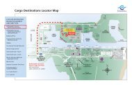
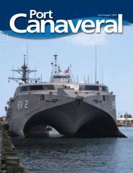
The <strong>Canaveral</strong> Harbor<br />
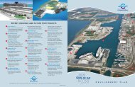
PORT DISTRICT<br />
Orange Counties; Thence meander northerly along<br />
said centerline to the centerline of Cheney Highway<br />
(State Road 50); Thence easterly along said centerline<br />
to the centerline of Barna Avenue; Thence northerly<br />
along said centerline to the centerline of Knox McRae<br />
Avenue; Thence southeasterly along said centerline to<br />
the centerline of Rosehill Avenue, in Section 22,<br />
Township 22 South, Range 35 East; Thence southerly<br />
along said centerline to the centerline of Cheney<br />
Highway (State Road 50); Thence easterly along said<br />
centerline to the centerline of the Florida East Coast<br />
Railway; Thence northerly along said centerline to the<br />
centerline of Harrison Street; Thence westerly along<br />
said centerline to the centerline of Barna Avenue;<br />
Thence northerly along said centerline to the centerline<br />
of Park Avenue (Old State Road 405); Thence<br />
northerly along said centerline to the centerline of<br />
Garden Street (State Road 406); Thence westerly<br />
along said centerline to the East line of the W 1/4 of<br />
Section 33, Township 21 South, Range 35 East;<br />
Thence northerly along said east line to the centerline<br />
of Malinda Lane; Thence easterly along said centerline<br />
to the centerline of North Washington Avenue<br />
(U.S. Highway #1); Thence northerly along said centerline<br />
to the centerline of Buffalo Road, in Section<br />
33, Township 21 South, Range 35 East; Thence easterly<br />
along said centerline and its easterly projection to<br />
the point of beginning.<br />
(c) District 3: Beginning at the intersection of the centerline<br />
of the Intracoastal Waterway of the Indian<br />
River and the centerline of the Beeline Expressway<br />
(State Road 528); Thence southerly along said centerline<br />
of the Intracoastal Waterway to the South line of<br />
Township 25 South; Thence westerly along said South<br />
line to the West line of Range 35 East, also being the<br />
county line between Osceola and Brevard Counties;<br />
Thence northerly along said West line intersection of<br />
the Brevard, Orange and Osceola County lines;<br />
Thence northerly along said Brevard and Orange<br />
County line to the centerline of State Road 520;<br />
Thence easterly along said centerline to the centerline<br />
of State Road 524; Thence southwesterly along said<br />
centerline and its southwesterly projection to the centerline<br />
of Lake Poinsett; Thence easterly along said<br />
centerline to the westerly projection of the centerline<br />
of Rockledge Creek; Thence easterly along said centerline<br />
and its westerly projection to the centerline of<br />
Interstate 95; Thence northwesterly along said centerline<br />
to the centerline of Pluckebaum Road; Thence<br />
easterly along said centerline to the centerline of<br />
Clearlake Road (State Road 501); Thence northerly<br />
along said centerline to the centerline of Lake Drive;<br />
Thence westerly along said centerline to the centerline<br />
of Cox Road; Thence northerly along said centerline<br />
to the centerline of State Road 524; Thence<br />
southwesterly along said centerline to the East- West<br />
Midsection line of Section 23, Township 24 South,<br />
Range 35 East; Thence westerly along said East-West<br />
Midsection line to the North-South Midsection line of<br />
said Section 23; Thence northerly along said North-<br />
South Midsection line to the South line of the N 1/4<br />
of said Section 23; Thence easterly along said South<br />
line to the West line of the NE 1/4 of the NE 1/4 of<br />
said Section 23; Thence northerly along said West line<br />
to the North line of the S 1/4 of the S 1/2 of the NE<br />
1/4 of the NE 1/4 of said Section 23; Thence easterly<br />
along said North line to the centerline of Cox Road;<br />
Thence northerly along said centerline to the East-<br />
West Midsection line of Section 13, Township 24<br />
South, Range 35 East; Thence easterly along said<br />
East-West Midsection line to the North-South<br />
Midsection line of said Section 13; Thence northerly<br />
along said North-South Midsection line to the South<br />
line of the N 1/4 of said Section 13, said line also<br />
being the North line of Cocoa North Subdivision, Unit<br />
4, as recorded in Plat Book 26 page 44, Public<br />
Records of Brevard County, Florida; Thence easterly<br />
along said South line to the West line of Cocoa North<br />
Subdivision, Unit 2, as recorded in Plat Book 21 page<br />
10, Public Records of Brevard County, Florida; Thence<br />
southerly, easterly, southeasterly and southwesterly<br />
along said West line to the North right of way line of<br />
London Boulevard; Thence easterly along said North<br />
right of way line to the West line of Cocoa North<br />
Subdivision, Unit 1, as recorded in Plat Book 21 page<br />
3, Public Records of Brevard County, Florida; Thence<br />
northerly along said West line and its northerly projection<br />
to the North right of way line of North Road;<br />
Thence southeasterly along said North right of way<br />
line to the East line of Section 13, Township 24 South,<br />
Range 35 East; Thence northerly along said East line<br />
to the centerline of the Beeline Expressway (State<br />
Road 528); Thence westerly along said centerline to<br />
the point of beginning.<br />
4