PDF, 3.4 MB - Warning Decision Training Branch - NOAA
PDF, 3.4 MB - Warning Decision Training Branch - NOAA
PDF, 3.4 MB - Warning Decision Training Branch - NOAA
Create successful ePaper yourself
Turn your PDF publications into a flip-book with our unique Google optimized e-Paper software.
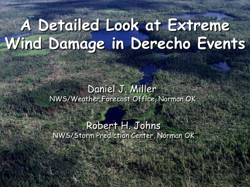
A Detailed Look at Extreme<br />
Wind Damage in Derecho Events<br />
Daniel J. Miller<br />
NWS/Weather Forecast Office, Norman OK<br />
Robert H. Johns<br />
NWS/Storm Prediction Center, Norman OK
Extreme Non-Tornadic Wind<br />
Damage Events<br />
XDW – eXtreme Damaging Wind<br />
Characterized by one or more of:<br />
‣ Widespread forest blowdowns<br />
‣ Observed damage of upper F1 intensity<br />
‣ Peak measured wind gusts >80kt
Extreme Non-Tornadic Wind<br />
Damage Events<br />
Pakwash Forest Blowdown Event<br />
18 July 1991 - Northwest Ontario Canada
What is a Derecho<br />
From Johns and Hirt, 1987<br />
1) Concentrated area of convectively induced wind damage and/or<br />
gusts >50kt (25m/s) that has a major axis length of at least 250<br />
nm (400 km)<br />
2) Reports must show a pattern of chronological progression<br />
3) At least 3 reports of convective gusts >65kt (33m/s) and/or F1<br />
intensity damage, these 3 reports must be separated by 40 nm<br />
(64 km) or more<br />
4) No more than 3 hours can elapse between successive wind<br />
damage (gust) events
What JH87 Did NOT Do<br />
Required 3 wind reports >65 kt - > 40 nm apart<br />
‣ No attempt made to discriminate between<br />
‘ordinary’ and ‘extreme’ events<br />
Bow Echo storm structure generally assumed – but:<br />
‣ No attempt to determine what specific convective<br />
elements within the derecho producing MCS were<br />
responsible for individual wind damage/gust events
A Derecho is an EVENT<br />
Derecho =<br />
Long-lived bow echo<br />
The derecho is NOT the MCS<br />
- it is the wind event produced by the MCS
What Convective Elements Are<br />
Associated with XDW Events<br />
Some Events Involve Supercells<br />
Supercell<br />
1 July 1997 – Central Minnesota<br />
29 June 1998 – Central Iowa<br />
4 July 1999 – Northern Minnesota<br />
27 May 2001 - Oklahoma<br />
Non-Supercell<br />
15 July 1995 – Upstate New York<br />
30-31 May 1998 – Minnesota to New York
1 July 1997 – Central Minnesota
1 July 1997 – Central Minnesota
1 July 1997 – Central Minnesota<br />
1 kft 4 kft 7 kft 9 kft<br />
12 kft 16 kft 22 kft 26 kft<br />
Range ~ 48 km (24 nm)
29 June 1998 – Central Iowa
29 June 1998 – Central Iowa
29 June 1998 – Central Iowa<br />
1 kft 4 kft<br />
10 kft 19 kft<br />
Range ~ 35 km (17 nm)
4 July 1999 – Northern Minnesota
4 July 1999 – Northern Minnesota
4 July 1999 – Northern Minnesota<br />
7 kft 17 kft<br />
24 kft 31 kft<br />
Range ~ 140 km (71 nm)
4 July 1999 Blowdown
4 July 1999 – Northern Minnesota<br />
BWCA Forest Blowdown Event
4 July 1999 Damage
4 July 1999 Blowdown
4 July 1999 Blowdown<br />
0.5 0<br />
Reflectivity<br />
VIL<br />
0.5 0<br />
Velocity<br />
0.5 0<br />
SR Velocity<br />
Range ~ 210 km (100 nm) Beam Height 9.5 kft
May 27, 2001 KS-OK-TX<br />
Memorial Day Derecho<br />
1 Death<br />
4 Injuries<br />
160,000 without power<br />
Over $300 million damage<br />
7 Tornado<br />
141 Hail<br />
186 wind<br />
Severe Reports 27 May 2001
The “Environment”<br />
CAPE 4874 j/kg<br />
CIN 0 j/kg<br />
LI -11<br />
OUN<br />
00Z 28 May 2001<br />
WBZ 11653 ft<br />
700-500 LR 7.6 deg/km<br />
LCL 858 mb
The “Environment”<br />
Sfc-6km shear 30 m/s<br />
Sfc-3km SRH 264m 2 /s 2<br />
OUN<br />
00Z 28 May 2001<br />
BRN 47<br />
BRN Shear 67 m 2 /s 2<br />
LFC-EL wind 280/30kt<br />
Storm motion 320/40kt
Oklahoma Mesonet Peak Winds
Visual Appearance<br />
Photo taken here<br />
at 723 pm CDT<br />
*<br />
KTLX Reflectivity 0025 UTC
27 May 2001– Oklahoma
27 May 2001– Oklahoma
27 May 2001– Oklahoma
27 May 2001– Oklahoma
Operational Considerations<br />
‣ Supercells within a derecho producing<br />
MCS can be associated with an enhanced<br />
threat for XDW<br />
‣ In some derecho events - the most extreme<br />
damage is associated with supercells<br />
‣ Supercell XDW events may have somewhat<br />
different characteristics than Bow Echo<br />
XDW events
Unique Characteristics of<br />
Supercell XDW Events<br />
1) Quite long in duration at any one location along<br />
the path (10-20 minutes - or longer in extreme<br />
cases vs. a few minutes or less for bow echoes)<br />
2) Have a much higher probability of being<br />
accompanied by large hail (> 4cm)<br />
3) Very tight damage gradients along the periphery<br />
of XDW area
Operational Considerations<br />
Most likely area for XDW is near the low-level<br />
mesocyclone and in the precip-filled RFD area<br />
Much more than a simple ‘downburst’<br />
Overall message is that warning forecasters<br />
need to be keenly aware of an enhanced<br />
potential for wind damage (possibly high-end)<br />
when circulations are present
Acknowledgements<br />
Jim LaDue, Mike Magsig, and Andy Wood<br />
NWS <strong>Warning</strong> <strong>Decision</strong> <strong>Training</strong> <strong>Branch</strong> (Formerly OSF/OTB)<br />
David Andra - NWSFO, Norman OK<br />
Todd Krause - NWSFO, Minneapolis MN<br />
Karl Jungbluth – NWSFO, Des Moines IA<br />
Ken LaPenta – NWSFO, Albany NY<br />
Rusty Kapela – NWSFO Milwaukee WI<br />
Charles Doswell III – National Severe Storms Laboratory<br />
Les Lemon – Consulting Meteorologist<br />
Jeff McKay – Owatonna MN
On the Internet<br />
Point your browser to:<br />
www.srh.noaa.gov/oun/papers/derecho.html


