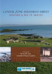
COASTAL ZONE ASSESSMENT SURVEY - SCAPE
COASTAL ZONE ASSESSMENT SURVEY - SCAPE
COASTAL ZONE ASSESSMENT SURVEY - SCAPE

Create successful ePaper yourself
Turn your PDF publications into a flip-book with our unique Google optimized e-Paper software.
5. <strong>SURVEY</strong> MAPS OF THE EAST COAST OF KINTYRE<br />
MAP 1: TARBERT TO FIONN PHORT<br />
Hinterland Geology and Coastal Geomorphology: The hinterland geology along<br />
this very uniform coastal cell is dominated by Dalradian schist (greywacke). The<br />
coastal edge is generally not highly indented and the intertidal area is narrow. There<br />
are no major embayments apart from East Loch Tarbert which lies on a major fault<br />
line forming a boundary between an area of basalt and the schist formations.<br />
Outcropping Tertiary dykes are rare along this section of coastline. The shoreline<br />
gradient is steep and there is very little in terms of backshore area due to the steepness<br />
of the cliffs. Access is very limited owing to the narrowness of the shoreline, which is<br />
normally inundated at MHWST. The hinterland rises steeply from the shoreline and<br />
is dominated by broadleaf cover.<br />
Erosion Class: The resilient nature of the cliffs and the lack of beaches in the strictest<br />
sense assign this area of coastline to mostly stable. There is some erosion and<br />
accretion around Tarbert itself though the sea walls protect the natural coastline.<br />
Although this area could not be surveyed by the field teams, a good length of this cell<br />
was observed from the ferry crossing from Tarbert to Arran.<br />
Built Heritage & Archaeology: The majority of the archaeology in this area is<br />
centred in and around Tarbert, although this may be a biased view as access to much<br />
of this area was restricted. The town of Tarbert appears to have medieval origins<br />
centred on the castle which stands on a prominent hill to the east of the present town.<br />
There is a suggestion of a burgh surrounding the castle though there is little known<br />
about it. The town of Tarbert contains several Listed Buildings within the survey<br />
area, most of which date to the 19 th or 20 th century. Other archaeological sites relate<br />
to the use of the sea, such as piers and Tarbert harbour, which also appears to date<br />
from the 19 th century.<br />
KACL/997/0<br />
19<br />
CFA