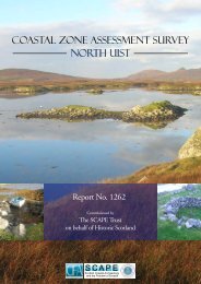
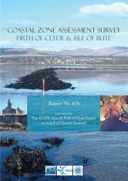
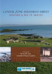
- Page 1 and 2: COASTAL ZONE ASSESSMENT SURVEY KINT
- Page 3 and 4: CONTENTS 1. Introduction 4 2. Metho
- Page 5 and 6: 1. INTRODUCTION 1.1 Background 1.1.
- Page 7 and 8: 2. METHODOLOGY 2.1 Introduction 2.1
- Page 9 and 10: advice of the Tarbert Coastguard th
- Page 11 and 12: 180000m NR NS 200000m 220000m Point
- Page 13 and 14: Sand dunes 3.1.4 Sand dunes are not
- Page 15 and 16: Sites of Special Scientific Interes
- Page 17 and 18: sheltered by the west coast of Arra
- Page 19 and 20: 4.2 Isle of Arran Prehistoric and E
- Page 21 and 22: KINTYRE MAP 1: HINTERLAND GEOLOGY A
- Page 23 and 24: KINTYRE MAP 1: EROSION ID Name of c
- Page 25 and 26: KINTYRE MAP 1: BUILT HERITAGE AND A
- Page 27: KINTYRE MAP 1 - BUILT HERITAGE AND
- Page 31 and 32: KINTYRE MAP 2: EROSION ID Name of c
- Page 33 and 34: KINTYRE MAP 2: BUILT HERITAGE AND A
- Page 35 and 36: MAP 3: SGEIR BHUIDE TO SGEIR NA LUI
- Page 37 and 38: KINTYRE MAP 3 -HINTERLAND GEOLOGY A
- Page 39 and 40: KINTYRE MAP 3 - EROSION CLASS Sgeir
- Page 41 and 42: KINTYRE MAP 3 - BUILT HERITAGE AND
- Page 43 and 44: KINTYRE MAP 4: HINTERLAND GEOLOGY A
- Page 45 and 46: KINTYRE MAP 4: EROSION ID Name of c
- Page 47 and 48: KINTYRE MAP 4: BUILT HERITAGE AND A
- Page 49 and 50: MAP 5: SGEIR NA H-INGHINN TO COUR B
- Page 51 and 52: KINTYRE MAP 5 -HINTERLAND GEOLOGY A
- Page 53 and 54: KINTYRE MAP 5 - EROSION CLASS Sgeir
- Page 55 and 56: KINTYRE MAP 5 - BUILT HERITAGE AND
- Page 57 and 58: KINTYRE MAP 6: HINTERLAND GEOLOGY A
- Page 59 and 60: KINTYRE MAP 6: EROSION ID Name of c
- Page 61 and 62: KINTYRE MAP 6: BUILT HERITAGE AND A
- Page 63 and 64: MAP 7: GROGPORT TO TORR MOR Hinterl
- Page 65 and 66: KINTYRE MAP 7 -HINTERLAND GEOLOGY A
- Page 67 and 68: KINTYRE MAP 7 - EROSION CLASS Grogp
- Page 69 and 70: KINTYRE MAP 7 - BUILT HERITAGE AND
- Page 71 and 72: KINTYRE MAP 8: HINTERLAND GEOLOGY A
- Page 73 and 74: KINTYRE MAP 8: EROSION ID Name of c
- Page 75 and 76: KINTYRE MAP 8: BUILT HERITAGE AND A
- Page 77 and 78: KINTYRE MAP 8 - BUILT HERITAGE AND
- Page 79 and 80:
KINTYRE MAP 9: HINTERLAND GEOLOGY A
- Page 81 and 82:
KINTYRE MAP 9: EROSION ID Name of c
- Page 83 and 84:
KINTYRE MAP 9: BUILT HERITAGE AND A
- Page 85 and 86:
MAP 10: UGADALE TO CARRICK POINT Hi
- Page 87 and 88:
KINTYRE MAP 10 -HINTERLAND GEOLOGY
- Page 89 and 90:
KINTYRE MAP 10 - EROSION CLASS Ugad
- Page 91 and 92:
131 Kildonald Bay NR72NE 5 NMRS 334
- Page 93 and 94:
MAP 11: CARRICK POINT TO KILCHOUSLA
- Page 95 and 96:
KINTYRE MAP 11 -HINTERLAND GEOLOGY
- Page 97 and 98:
KINTYRE MAP 11 - EROSION CLASS Carr
- Page 99 and 100:
3042 177 Kilchousland OS 1st ed NR
- Page 101 and 102:
MAP 12: KILCHOUSLAND TO TRENCH POIN
- Page 103 and 104:
KINTYRE MAP 12 -HINTERLAND GEOLOGY
- Page 105 and 106:
KINTYRE MAP 12 - EROSION CLASS Kilc
- Page 107 and 108:
KINTYRE MAP 12 - BUILT HERITAGE AND
- Page 109 and 110:
ARRAN MAP 1: HINTERLAND GEOLOGY AND
- Page 111 and 112:
ARRAN MAP 1: EROSION ID Name of coa
- Page 113 and 114:
ARRAN MAP 1: BUILT HERITAGE AND ARC
- Page 115 and 116:
MAP 2: AIRD NAN RON TO PORT MOR Hin
- Page 117 and 118:
ARRAN MAP 2 -HINTERLAND GEOLOGY AND
- Page 119 and 120:
ARRAN MAP 2 - EROSION CLASS Aird na
- Page 121 and 122:
ARRAN MAP 2 - BUILT HERITAGE AND AR
- Page 123 and 124:
ARRAN MAP 3: HINTERLAND GEOLOGY AND
- Page 125 and 126:
ARRAN MAP 3: EROSION ID Name of coa
- Page 127 and 128:
ARRAN MAP 3: BUILT HERITAGE AND ARC
- Page 129 and 130:
MAP 4: TORR NAN UAIN TO PORT A’ G
- Page 131 and 132:
ARRAN MAP 4 -HINTERLAND GEOLOGY AND
- Page 133 and 134:
ARRAN MAP 4 - EROSION CLASS Torr na
- Page 135 and 136:
ARRAN MAP 4 - BUILT HERITAGE AND AR
- Page 137 and 138:
ARRAN MAP 5: HINTERLAND GEOLOGY AND
- Page 139 and 140:
ARRAN MAP 5: EROSION ID Name of coa
- Page 141 and 142:
ARRAN MAP 5: BUILT HERITAGE AND ARC
- Page 143 and 144:
MAP 6: PORT LEACACH TO WHITING BAY
- Page 145 and 146:
ARRAN MAP 6 -HINTERLAND GEOLOGY AND
- Page 147 and 148:
ARRAN MAP 6 - EROSION CLASS Port Le
- Page 149 and 150:
94 Largymore OS 1st ed NS 0467 2510
- Page 151 and 152:
MAP 7: WHITING BAY TO GORTONALLISTE
- Page 153 and 154:
ARRAN MAP 7 -HINTERLAND GEOLOGY AND
- Page 155 and 156:
ARRAN MAP 7 - EROSION CLASS Whiting
- Page 157 and 158:
104 Arnhall Lodge NS02NW 42.01 NMRS
- Page 159 and 160:
ARRAN MAP 7 - BUILT HERITAGE AND AR
- Page 161 and 162:
ARRAN MAP 8: HINTERLAND GEOLOGY AND
- Page 163 and 164:
ARRAN MAP 8: EROSION ID Name of coa
- Page 165 and 166:
ARRAN MAP 8: BUILT HERITAGE AND ARC
- Page 167 and 168:
ARRAN MAP 8 - BUILT HERITAGE AND AR
- Page 169 and 170:
7.6 There are no sites dating to be
- Page 171 and 172:
Kintyre Period Categories WWII 18th
- Page 173 and 174:
8. SURVEY RESULTS FOR THE ISLE OF A
- Page 175 and 176:
Arran Erosion Class 20 18 16 14 Kil
- Page 177 and 178:
Arran Site Condition 80 70 60 50 40
- Page 179 and 180:
Name Gazetteer No NGR No Site Type
- Page 181 and 182:
10.2 Cartographic sources British G
- Page 183 and 184:
10.4 Aerial Photographic Record Kin
- Page 185 and 186:
19 Skipness Pier OS 2nd ed NR 9223
- Page 187 and 188:
80 Grianain NR84SW 7 NMRS 44961 NR
- Page 189 and 190:
137 Kildonald Bay Fieldwalking NR 7
- Page 191 and 192:
APPENDIX 2 - ARRAN: BUILT HERITAGE
- Page 193 and 194:
13453 62 Drimla Lodge NS02SW 42 NMR
- Page 195 and 196:
115 Whiting Bay Church NS02NW 56 NM
- Page 197 and 198:
160 Marine House Hotel NS03SW 60 NM
- Page 199 and 200:
Plate 3 - View of Island Muller wit
- Page 201 and 202:
Plate 7 - View of the Arran coastli
- Page 203:
Plate 11 - Possible remains of an a