

download pdf - Utah Geological Survey - Utah.gov
download pdf - Utah Geological Survey - Utah.gov
download pdf - Utah Geological Survey - Utah.gov

Create successful ePaper yourself
Turn your PDF publications into a flip-book with our unique Google optimized e-Paper software.
4<br />
GROUNDWATER SAMPLING<br />
Groundwater samples were collected using standard U.S.<br />
<strong>Geological</strong> <strong>Survey</strong> field techniques summarized by Wilde<br />
and others (1998). Each piezometer was purged of at least<br />
3 well volumes prior to sampling, either using a downhole<br />
sampling pump in the case of the Navajo completion<br />
or by allowing the well to flow for an extended period in<br />
the case of the Entrada completion. Samples collected<br />
from Courthouse Wash Boundary Spring were collected<br />
via a peristaltic pump from the deepest part of the large<br />
spring pool near the point of seepage. Samples were collected<br />
in triplicate in thoroughly rinsed, brown one-liter<br />
glass bottles with sealed polycone caps. Each bottle was<br />
sealed with electrical tape at the sampling site and kept<br />
<strong>Utah</strong> <strong>Geological</strong> <strong>Survey</strong><br />
iced until delivery to the Brigham Young University Hydrogeology<br />
Laboratory. Field parameters including temperature,<br />
specific conductance, pH, and dissolved oxygen were<br />
measured at the time of sampling using a Hydrolab Quanta<br />
multi-parameter meter that was periodically calibrated<br />
with reference solutions (table 1). Samples for dissolved<br />
gas analysis were collected using standard diffusion samplers<br />
placed in the purged piezometers at a depth of 30<br />
feet below water level or the deepest part of the spring<br />
pool. Diffusion samplers were allowed to equilibrate for<br />
24 hours prior to retrieval.<br />
All laboratory work for groundwater samples, except carbon<br />
isotopes, was performed at the Brigham Young University<br />
Hydrogeology Lab. Concentrations of major dissolved<br />
anions and cations, and dissolved nitrate were de-<br />
4365<br />
4360<br />
4355<br />
Groundwater elevation (ft)<br />
4350<br />
4345<br />
4340<br />
4335<br />
4330<br />
4325<br />
Entrada Completion<br />
Navajo Completion<br />
4320<br />
4315<br />
4310<br />
03/02/12 05/01/12 06/30/12 08/29/12 10/28/12<br />
Date<br />
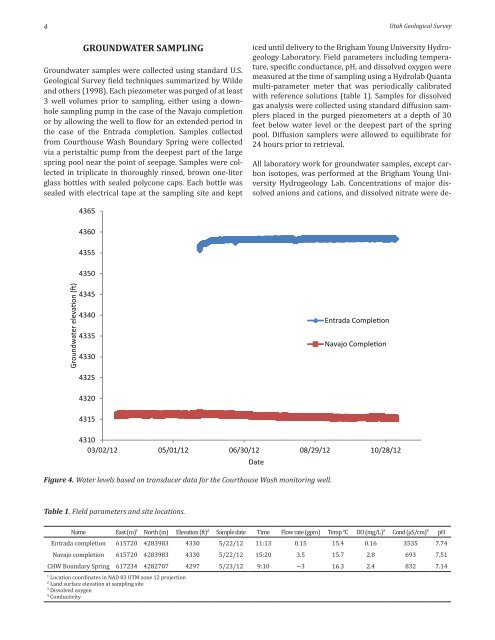
Figure 4. Water levels based on transducer data for the Courthouse Wash monitoring well.<br />
Table 1. Field parameters and site locations.<br />
Name East (m) 1 North (m) Elevation (ft) 2 Sample date Time Flow rate (gpm) Temp °C DO (mg/L) 3 Cond (µS/cm) 4 pH<br />
Entrada completion 615720 4283983 4330 5/22/12 11:13 0.15 15.4 0.16 3535 7.74<br />
Navajo completion 615720 4283983 4330 5/22/12 15:20 3.5 15.7 2.8 693 7.51<br />
CHW Boundary Spring 617234 4282707 4297 5/23/12 9:10 ~3 16.3 2.4 832 7.14<br />
1<br />
Location coordinates in NAD 83 UTM zone 12 projection<br />
2<br />
Land surface elevation at sampling site<br />
3<br />
Dissolved oxygen<br />
4<br />
Conductivity


