Gulf Coast Coal and Petrochemical Facilities Still Not Storm Ready
Gulf Coast Coal and Petrochemical Facilities Still Not Storm Ready
Gulf Coast Coal and Petrochemical Facilities Still Not Storm Ready

Create successful ePaper yourself
Turn your PDF publications into a flip-book with our unique Google optimized e-Paper software.
– 10 –<br />
GMC Response to Hurricane Isaac:<br />
In August 2012, anticipating the arrival of Hurricane Isaac, GMC members made the following<br />
preparations to identify areas at risk from the storm, document weatherproofing efforts being made at<br />
industrial facilities, <strong>and</strong> inform residents of potential environmental <strong>and</strong> public health impacts that<br />
could arise from the storm.<br />
● LABB created a map showing the oil <strong>and</strong> gas infrastructure in the projected path of Isaac <strong>and</strong><br />
publicized the iWitness Pollution Map to facilitate reporting about industrial accidents.<br />
● SkyTruth published seven reports identifying areas likely to be hardest hit <strong>and</strong> tracked the<br />
arrival of the storm on weather <strong>and</strong> earth-observation satellites.<br />
● SouthWings flew with <strong>Gulf</strong> Restoration Network<br />
(GRN) to document the pre-storm status of<br />
refineries <strong>and</strong> coal terminals in Southern<br />
Louisiana.<br />
● GRN, Lower Mississippi Riverkeeper, <strong>and</strong><br />
SkyTruth warned the public about the<br />
possibility of the storm stirring up residual oil<br />
from the BP / Deepwater Horizon disaster <strong>and</strong><br />
promoted reporting of spills, tar balls/mats, <strong>and</strong><br />
other incidents to the National Response<br />
Center (NRC) <strong>and</strong> the LABB’s iWitness<br />
Pollution Map.<br />
After Isaac’s l<strong>and</strong>fall, GMC members worked together<br />
to collect data documenting the resulting pollution:<br />
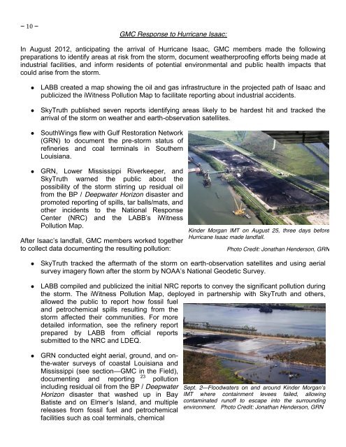
Kinder Morgan IMT on August 25, three days before<br />
Hurricane Isaac made l<strong>and</strong>fall.<br />
Photo Credit: Jonathan Henderson, GRN<br />
● SkyTruth tracked the aftermath of the storm on earth-observation satellites <strong>and</strong> using aerial<br />
survey imagery flown after the storm by NOAA’s National Geodetic Survey.<br />
● LABB compiled <strong>and</strong> publicized the initial NRC reports to convey the significant pollution during<br />
the storm. The iWitness Pollution Map, deployed in partnership with SkyTruth <strong>and</strong> others,<br />
allowed the public to report how fossil fuel<br />
<strong>and</strong> petrochemical spills resulting from the<br />
storm affected their communities. For more<br />
detailed information, see the refinery report<br />
prepared by LABB from official reports<br />
submitted to the NRC <strong>and</strong> LDEQ.<br />
● GRN conducted eight aerial, ground, <strong>and</strong> onthe-water<br />
surveys of coastal Louisiana <strong>and</strong><br />
Mississippi (see section—GMC in the Field),<br />
documenting <strong>and</strong> reporting 23 pollution<br />
including residual oil from the BP / Deepwater<br />
Horizon disaster that washed up in Bay<br />
Batiste <strong>and</strong> on Elmer’s Isl<strong>and</strong>, <strong>and</strong> multiple<br />
releases from fossil fuel <strong>and</strong> petrochemical<br />
facilities such as coal terminals, chemical<br />
Sept. 2—Floodwaters on <strong>and</strong> around Kinder Morgan’s<br />
IMT where containment levees failed, allowing<br />
contaminated runoff to escape into the surrounding<br />
environment. Photo Credit: Jonathan Henderson, GRN