Gulf Coast Coal and Petrochemical Facilities Still Not Storm Ready
Gulf Coast Coal and Petrochemical Facilities Still Not Storm Ready
Gulf Coast Coal and Petrochemical Facilities Still Not Storm Ready

Create successful ePaper yourself
Turn your PDF publications into a flip-book with our unique Google optimized e-Paper software.
– 12 –<br />
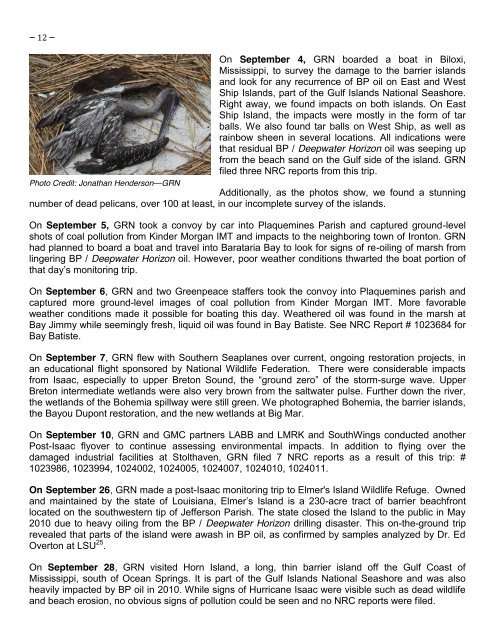
Photo Credit: Jonathan Henderson—GRN<br />
On September 4, GRN boarded a boat in Biloxi,<br />
Mississippi, to survey the damage to the barrier isl<strong>and</strong>s<br />
<strong>and</strong> look for any recurrence of BP oil on East <strong>and</strong> West<br />
Ship Isl<strong>and</strong>s, part of the <strong>Gulf</strong> Isl<strong>and</strong>s National Seashore.<br />
Right away, we found impacts on both isl<strong>and</strong>s. On East<br />
Ship Isl<strong>and</strong>, the impacts were mostly in the form of tar<br />
balls. We also found tar balls on West Ship, as well as<br />
rainbow sheen in several locations. All indications were<br />
that residual BP / Deepwater Horizon oil was seeping up<br />
from the beach s<strong>and</strong> on the <strong>Gulf</strong> side of the isl<strong>and</strong>. GRN<br />
filed three NRC reports from this trip.<br />
Additionally, as the photos show, we found a stunning<br />
number of dead pelicans, over 100 at least, in our incomplete survey of the isl<strong>and</strong>s.<br />
On September 5, GRN took a convoy by car into Plaquemines Parish <strong>and</strong> captured ground-level<br />
shots of coal pollution from Kinder Morgan IMT <strong>and</strong> impacts to the neighboring town of Ironton. GRN<br />
had planned to board a boat <strong>and</strong> travel into Barataria Bay to look for signs of re-oiling of marsh from<br />
lingering BP / Deepwater Horizon oil. However, poor weather conditions thwarted the boat portion of<br />
that day’s monitoring trip.<br />
On September 6, GRN <strong>and</strong> two Greenpeace staffers took the convoy into Plaquemines parish <strong>and</strong><br />
captured more ground-level images of coal pollution from Kinder Morgan IMT. More favorable<br />
weather conditions made it possible for boating this day. Weathered oil was found in the marsh at<br />
Bay Jimmy while seemingly fresh, liquid oil was found in Bay Batiste. See NRC Report # 1023684 for<br />
Bay Batiste.<br />
On September 7, GRN flew with Southern Seaplanes over current, ongoing restoration projects, in<br />
an educational flight sponsored by National Wildlife Federation. There were considerable impacts<br />
from Isaac, especially to upper Breton Sound, the “ground zero” of the storm-surge wave. Upper<br />
Breton intermediate wetl<strong>and</strong>s were also very brown from the saltwater pulse. Further down the river,<br />
the wetl<strong>and</strong>s of the Bohemia spillway were still green. We photographed Bohemia, the barrier isl<strong>and</strong>s,<br />
the Bayou Dupont restoration, <strong>and</strong> the new wetl<strong>and</strong>s at Big Mar.<br />
On September 10, GRN <strong>and</strong> GMC partners LABB <strong>and</strong> LMRK <strong>and</strong> SouthWings conducted another<br />
Post-Isaac flyover to continue assessing environmental impacts. In addition to flying over the<br />
damaged industrial facilities at Stolthaven, GRN filed 7 NRC reports as a result of this trip: #<br />
1023986, 1023994, 1024002, 1024005, 1024007, 1024010, 1024011.<br />
On September 26, GRN made a post-Isaac monitoring trip to Elmer's Isl<strong>and</strong> Wildlife Refuge. Owned<br />
<strong>and</strong> maintained by the state of Louisiana, Elmer’s Isl<strong>and</strong> is a 230-acre tract of barrier beachfront<br />
located on the southwestern tip of Jefferson Parish. The state closed the Isl<strong>and</strong> to the public in May<br />
2010 due to heavy oiling from the BP / Deepwater Horizon drilling disaster. This on-the-ground trip<br />
revealed that parts of the isl<strong>and</strong> were awash in BP oil, as confirmed by samples analyzed by Dr. Ed<br />
Overton at LSU 25 .<br />
On September 28, GRN visited Horn Isl<strong>and</strong>, a long, thin barrier isl<strong>and</strong> off the <strong>Gulf</strong> <strong>Coast</strong> of<br />
Mississippi, south of Ocean Springs. It is part of the <strong>Gulf</strong> Isl<strong>and</strong>s National Seashore <strong>and</strong> was also<br />
heavily impacted by BP oil in 2010. While signs of Hurricane Isaac were visible such as dead wildlife<br />
<strong>and</strong> beach erosion, no obvious signs of pollution could be seen <strong>and</strong> no NRC reports were filed.