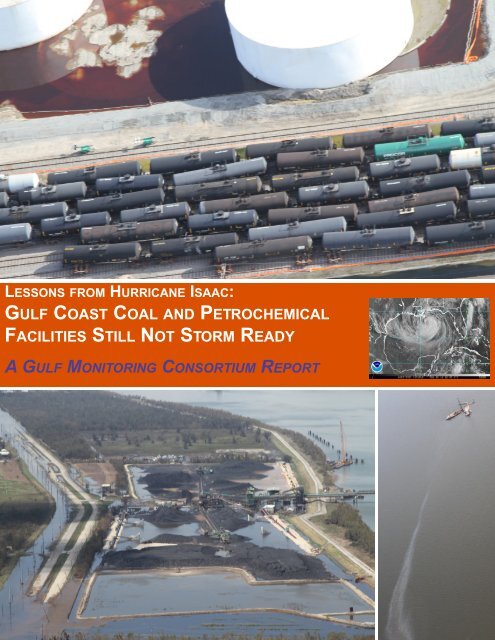
Gulf Coast Coal and Petrochemical Facilities Still Not Storm Ready
Gulf Coast Coal and Petrochemical Facilities Still Not Storm Ready
Gulf Coast Coal and Petrochemical Facilities Still Not Storm Ready

Create successful ePaper yourself
Turn your PDF publications into a flip-book with our unique Google optimized e-Paper software.
– 2 –<br />
Key Findings<br />
Finding #1: Substantial amounts of pollution were released into the environment due to<br />
damage from the only hurricane to make l<strong>and</strong>fall on the <strong>Gulf</strong> <strong>Coast</strong> in 2012<br />
During <strong>and</strong> following Hurricane Isaac, from August 28 to September 18, 2012, a total of 130 accidents<br />
were reported to the NRC as a direct result of the storm; 69 additional reports to the NRC may be<br />
related to the storm given the report date <strong>and</strong> incident type, but these reports did not specifically<br />
mention Hurricane Isaac. Of the 130 accidents attributed to the hurricane, 108 reports identified<br />
specific pollutants released or suspected to have been released. There were an additional 32 reports<br />
not associated with specific pollutants released (e.g., reports of unmarked 55-gallon drums found in<br />
storm debris). Of the 108 NRC <strong>and</strong> LDEQ reports of pollution due to Hurricane Isaac, 45 provided<br />
estimates of the amount of specific pollutants released, totaling at least 12,941,044 gallons of<br />
pollutants <strong>and</strong> contaminated water, <strong>and</strong> over 192 tons of gases released into the environment of<br />
the <strong>Gulf</strong> <strong>Coast</strong> Region.<br />
In red, the path of Hurricane Isaac, <strong>and</strong> in orange, pollution reports received by the NRC between August 28 <strong>and</strong><br />
September 11, 2012, the dates of the storm <strong>and</strong> the initial cleanup.<br />
Finding #2: Harmful chemicals, including recognized neurotoxins <strong>and</strong> carcinogens, were<br />
released due to damage from the storm<br />
Besides the aforementioned reports with pollution estimates, two-thirds of the incidents reported to<br />
the NRC due to Hurricane Isaac did not give any estimate of the amount of materials released. While<br />
the actual releases were probably significantly greater than the amounts given below <strong>and</strong> groups like<br />
LABB are still finding incident reports from operators, we at least have documentation from the NRC<br />
of the following releases resulting from Hurricane Isaac:
– 3 –<br />
In addition to the releases reported<br />
to the NRC noted here, Stolthaven<br />
New Orleans LLC initially reported<br />
to the NRC a potential release of as<br />
much as 191,331 gallons of<br />
chemicals, including a wide range of<br />
carcinogens <strong>and</strong> toxicants. Later,<br />
between September 1 <strong>and</strong><br />
September 19, Stolthaven verbally<br />
reported spill estimates to LDEQ,<br />
indicating a potential release of<br />
much as 227,608 gallons. On<br />
October 4, 37 days after the storm,<br />
Stolthaven submitted its final report<br />
to LDEQ, 1 reporting a total spill of<br />
169,810 gallons of oil <strong>and</strong><br />
petrochemicals, including:<br />
Octene—80,467 gallons (gal.)<br />
Diethanolamine—76,998 gal.<br />
Ultra S-4 (lubricant)—6,168 gal.<br />
Vivatac—2,906 gal.<br />
Soybean Soapstocks—2,051 gal.<br />
Alcohols, C10-16—1,220 gal. [Safol<br />
23, Lauryl Myristyl Alcohol]<br />
Finding #3: Despite advance<br />
warning of the storm path <strong>and</strong><br />
intensity, operators used the<br />
weather as an excuse for<br />
pollution<br />
Weather is frequently cited by fossil<br />
fuel <strong>and</strong> petrochemical facilities as a<br />
cause of accidents <strong>and</strong> chemical<br />
releases, but hurricanes <strong>and</strong> tropical<br />
storms are generally predictable<br />
<strong>and</strong> are an annual occurrence in the<br />
<strong>Gulf</strong> Region. Citing storms <strong>and</strong><br />
hurricanes as the cause of pollution<br />
suggests poor planning <strong>and</strong>/or<br />
inadequate protections.
– 4 –<br />
For example, Motiva Norco Refinery in St. Charles Parish blamed the weather for its pollution, while<br />
the Valero refinery next door shut down in advance of the hurricane <strong>and</strong> reported no incident. The<br />
Motiva refinery encountered major problems <strong>and</strong> had to send workers out in the middle of the storm<br />
to tie down equipment 2 .<br />
Instead of acknowledging this failure in its report to LDEQ, the refinery said pollution was “from the<br />
unexpected shutdown <strong>and</strong> restart of the site before <strong>and</strong> during inclement weather due to l<strong>and</strong>fall of<br />
Hurricane Isaac 3 .” However, Hurricane Isaac was not an unexpected event, <strong>and</strong> continuing to operate<br />
into the storm resulted in the release of chemicals <strong>and</strong> gases. Between trying to keep the flares lit in<br />
the high wind <strong>and</strong> continuing to run the flares for days after the hurricane (for as-yet undisclosed<br />
reasons), Motiva’s Norco Refinery released 135 tons of pollution including 27 tons of volatile organic<br />
compounds (VOCs), 16.5 tons of sulfur dioxide, <strong>and</strong> nearly a ton of benzene, a known carcinogen.<br />
Other examples from Hurricane Isaac include ExxonMobil’s Chalmette Refining LLC (CRLLC) who<br />
wrote to LDEQ on August 31, “CRLLC asks LDEQ <strong>and</strong> EPA to exercise enforcement discretion <strong>and</strong><br />
not seek penalties for the activities undertaken to respond to <strong>and</strong> recover from the Hurricane Isaac,”<br />
<strong>and</strong>, “due to higher than normal rain <strong>and</strong> wind volumes, flare pilots experienced temporary outages 4 .”<br />
Hurricanes typically bring “higher than normal” rain <strong>and</strong> winds. What’s more, weather forecasts<br />
predict more intense conditions days in advance, so refineries should not be surprised when such<br />
conditions arise. In many of these cases the weather was described as an uncontrollable anomaly,<br />
not a predictable event that can be accommodated. Proper preparation <strong>and</strong>/or better management<br />
may have prevented or mitigated these <strong>and</strong> other pollution incidents.<br />
Finding #4: Fossil fuel infrastructure in the <strong>Gulf</strong> Region is vulnerable to predictable tropical<br />
weather events<br />
Hurricane Isaac made l<strong>and</strong>fall on August 28, 2012 as a Category 1 storm, the weakest classification<br />
for a hurricane. By wind speed, it was among the weakest of the 28 hurricanes that have made<br />
l<strong>and</strong>fall in Louisiana since 1956. Isaac’s rainfall totals <strong>and</strong> storm surge height, although significant,<br />
were by no means unprecedented—multiple storms in Louisiana <strong>and</strong> elsewhere have exceeded<br />
Isaac 5 . Ultimately, Hurricane Isaac was a predictable event.<br />
Despite the relatively unremarkable nature of the storm, GMC documented numerous examples of<br />
pollution from infrastructure failures at fossil fuel transport, storage, <strong>and</strong> refining facilities during <strong>and</strong><br />
after the storm. These failures included inadequate levees which allowed contaminated water to spill<br />
into surrounding wetl<strong>and</strong>s, waterways, <strong>and</strong> communities; insufficient storage capacity to h<strong>and</strong>le<br />
stormwater <strong>and</strong>/or wastewater during predictable high-rain events; tanks <strong>and</strong> railroad tanker cars<br />
shifted or upset by the storm <strong>and</strong> floodwaters, <strong>and</strong> other weaknesses.<br />
Chemical processing <strong>and</strong> storage facilities:<br />
● On September 11, fourteen days after the storm, Stolthaven New Orleans LLC’s petroleum<br />
<strong>and</strong> chemical storage <strong>and</strong> transfer terminal in Braithwaite, LA reported a worst-case scenario<br />
potential release of 191,337 gallons of oil <strong>and</strong> petrochemicals 6 . Thirty-seven days later on<br />
October 4, they submitted their “final estimated quantities released” to LDEQ 7 —169,810<br />
gallons, or 88% of their maximum estimate.
– 5 –<br />
Flooded Stolthaven chemical facility observed on August 31 by a NOAA aerial survey of the storm damage. The facility<br />
reported releasing 169,810 gallons of oil <strong>and</strong> petrochemicals in the flood. Image: NOAA/National Geodetic Survey<br />
It took Stolthaven 37 days to report their best estimate to the state, which differed dramatically<br />
from the inventory of chemicals they initially reported might have been released, which were<br />
based on a pre-storm inventory. While bulk quantities of benzene <strong>and</strong> toluene were not<br />
actually released as initially reported, no early reports even suggested a release of Octene,<br />
Ultra S-4 lubricating oil, or Vivatec, substances which were in fact released in quantities of<br />
80,467 gallons, 6,168 gallons, <strong>and</strong> 2,906 gallons respectively. The discrepancy means that<br />
emergency responders, residents returning to their homes, <strong>and</strong> possibly even workers were<br />
not accurately informed of potential health <strong>and</strong> environmental risks of these <strong>and</strong> other<br />
chemicals contaminating the floodwaters. The total volume of oil <strong>and</strong> chemicals spilled here<br />
almost equals all of the other 45 Hurricane Isaac-related incidents that provided an estimated<br />
spill volume.<br />
● The ExxonMobil Chemical Plant in Baton Rouge reported numerous problems from the wind,<br />
including the hatches of tanks that simply blew away. According to reports, “Several floating<br />
roof tank socks were discovered missing or torn as a result of high winds. Multiple tank<br />
hatches discovered missing or open as a result of high winds 8 .”<br />
Oil refineries:<br />
● The Marathon Refinery in Garyville dumped 12.6 million gallons of untreated stormwater runoff<br />
from their process areas into Lake Maurepas after the storm, stating in their report to LDEQ<br />
that they “had reached the on-site storage capacity 9 .”
– 6 –<br />
● Interviews with workers at the Motiva refinery in Norco revealed dangerous conditions inside<br />
the plant during l<strong>and</strong>fall. All of the compressors malfunctioned because they were flooded <strong>and</strong><br />
workers had to go out in the hurricane to tie machinery down while units were malfunctioning.<br />
As a result, according to refinery reports, the refinery released many chemicals <strong>and</strong> gases<br />
during the storm, including benzene <strong>and</strong> carbon dioxide 10 .<br />
● At the Phillips 66 Alliance Refinery<br />
in Belle Chasse, storm surge<br />
overtopped their western levee,<br />
flooding the facility. The operators<br />
reported that oily wastewater<br />
overflowed the collection system<br />
<strong>and</strong> that oil had “come out of their<br />
sewers <strong>and</strong> into the floodwater 11 .”<br />
Phillips 66 only reported that the<br />
amount of oil exceeded 1 barrel;<br />
<strong>and</strong> claimed a sheen was only<br />
observed on the Mississippi River<br />
on August 30, but not on the<br />
following day. Aerial survey<br />
imagery from NOAA on August 31<br />
<strong>and</strong> GMC monitoring flights on<br />
September 2 <strong>and</strong> 10 documented<br />
oily sheens on floodwaters inside<br />
the facility <strong>and</strong> lingering on fields<br />
around the refinery, but the source<br />
is indeterminate.<br />
Oily sheen on water at the flooded Phillips 66 Alliance refinery in<br />
Belle Chase observed by a GMC overflight on September 2.<br />
Photo Credit: Jonathan Henderson, GRN<br />
● In Chalmette, the Valero Refinery spilled 47 gallons of slop oil including 7.8 pounds of<br />
benzene. Valero reported “the root cause of this spill to be inadequate containment for the<br />
heavy rains <strong>and</strong> high winds experienced during hurricane Isaac 12 .” The pollution during<br />
Hurricane Isaac went into the 20 Arpent Canal, where children play.<br />
● Exxon’s Chalmette Refinery shut down in advance of the storm, but had significant issues with<br />
pollution controls during shut-down resulting in a 58 ton release of sulfur dioxide. Furthermore,<br />
even though the Chalmette Refinery made additional preparation for the storm, they still had to<br />
discharge an undefined amount of untreated stormwater runoff from the facility due to<br />
insufficient storage capacity 13 . Even when facilities are not operating, they sometimes report<br />
inability to retain all potentially polluted water until it can be treated.
– 7 –<br />
Left: Sept. 2—Flooded Kinder Morgan International Marine Terminals at Myrtle Grove, LA where floodwaters saturate dirty<br />
fossil fuels such as coal <strong>and</strong> petroleum.<br />
Right: Sept. 10— Same facility with floodwaters being pumped out into surrounding waterways.<br />
Photo Credits: Left—Jonathan Henderson, GRN; Right—Jeffrey Dubinsky for LMRK<br />
<strong>Coal</strong> Terminals:<br />
● Kinder Morgan’s International Marine Terminals (IMT) facility, on the Mississippi River in<br />
Plaquemines Parish, flooded during Hurricane Isaac. As a result of the flooding, when barriers<br />
built around the facility failed, the runoff inundated surrounding waters, wetl<strong>and</strong>s, <strong>and</strong> farml<strong>and</strong><br />
with stormwater contaminated by contact with stockpiles of coal, petcoke, or other similar<br />
materials. GRN documented the pre-storm condition of the site during a SouthWings flyover on<br />
August 25. Following the storm, GRN conducted aerial surveys of storm impacts with Southern<br />
Seaplanes on September 2 <strong>and</strong> with SouthWings on September 10, in addition to on-theground<br />
investigation on September 6. GRN documented International Marine Terminal actively<br />
pumping contaminated floodwaters out of their facility grounds into the surrounding wetl<strong>and</strong>s,<br />
river, <strong>and</strong> environment. Aerial photos documented a dark coating of sediments spreading for<br />
miles away from the facility, which GRN concluded was coal or petcoke from the facility<br />
threatening the nearby community of Ironton. GRN also documented cattle wading through<br />
contaminated floodwaters <strong>and</strong> drinking from the runoff being pumped from the facility, <strong>and</strong><br />
birds searching for food in dirty drainage ditches near the terminal.<br />
● GRN documented conditions at another coal terminal on the Mississippi River in Plaquemines<br />
Parish, United Bulk Terminal LLC. Flooding at this terminal also resulted in contamination of<br />
surrounding fields <strong>and</strong> waterways.<br />
In addition to these cases of confirmed infrastructure damage, GMC members observed oiling in<br />
several marsh or offshore locations that appeared to be associated with damaged infrastructure. In<br />
several of these instances we submitted reports to the NRC, alerting government agencies to the<br />
suspected pollution incidents documented by GMC members.
– 8 –<br />
● As the clouds cleared after the storm,<br />
GMC member SkyTruth began<br />
monitoring satellite images collected<br />
by NASA’s Moderate Resolution<br />
Imaging Spectroradiometer (MODIS)<br />
<strong>and</strong> detected a small offshore slick at<br />
an improperly shut in Chevron well 14 .<br />
Right: Detail of an image from NASA’s Aqua<br />
satellite, consistent with an NRC report<br />
received from High Isl<strong>and</strong> Block 563.<br />
● On a SouthWings flyover on September 10, Lower Mississippi Riverkeeper, LABB, <strong>and</strong> GRN<br />
observed <strong>and</strong> documented multiple problems, including (1) suspected oiling of marshes in Bay<br />
Jimmy, near a leaking oil production <strong>and</strong> storage tank facility in northern Barataria Bay; (2) an<br />
apparently leaking oil production facility in the Pass a l’Outre Wildlife Management Area;; (3)<br />
oily sheen at offshore sites <strong>and</strong> in the vicinity of a production/storage facility in southern<br />
Plaquemines parish; <strong>and</strong> (4) an oil leak in northern Barataria Bay that appeared to be<br />
emanating from either a pipeline below the surface or a nearby facility.<br />
Finding #5: Oil from the BP / Deepwater Horizon disaster continues to wash ashore<br />
Twelve miles of beach were closed after Hurricane Isaac between Gr<strong>and</strong> Isle <strong>and</strong> Port Fourchon<br />
because of the large amounts of oil present. Furthermore, tarballs were found washed ashore as far<br />
east as Alabama. Auburn University reported that 37,000 pounds of tar balls, tar mat fragments, <strong>and</strong><br />
other oil-tainted material were removed from Alabama beaches in the wake of Hurricane Isaac 15 .<br />
On September 2, Lower Mississippi<br />
Riverkeeper took samples of suspected<br />
BP oil washed up on Fourchon Beach just<br />
before it was closed. On September 4, in<br />
partnership with Greenpeace, GRN<br />
conducted ground surveys of East Ship<br />
<strong>and</strong> West Ship isl<strong>and</strong>s, part of the <strong>Gulf</strong><br />
Isl<strong>and</strong>s National Seashore, <strong>and</strong><br />
Greenpeace sent samples of tar balls<br />
suspected to be from the BP oil spill for<br />
laboratory analysis. On September 6<br />
Consortium member GRN <strong>and</strong> their<br />
colleagues at Greenpeace surveyed<br />
storm damage by boat <strong>and</strong> documented<br />
fresh oil coating the marsh in Bay Batiste<br />
in northern Barataria Bay.<br />
At Elmer’s Isl<strong>and</strong>, La., one of countless tarballs still washing ashore from<br />
the BP/ Deepwater Horizon Oil Disaster in 2010.<br />
Photo Credit: Jonathan Henderson, GRN
– 9 –<br />
GRN’s Jonathan Henderson collecting oil samples from a marsh at<br />
Bay Batiste after Hurricane Isaac.<br />
Photo Credit: GRN<br />
Oil samples from the marsh in Bay Batiste<br />
were sent to Dr. Ed Overton at Louisiana<br />
State University for analysis. Dr. Overton<br />
found that the fingerprint of oil samples<br />
taken in Bay Batiste matched that of oil<br />
from BP’s failed Macondo well,<br />
suggesting that oil from the BP /<br />
Deepwater Horizon disaster continues to<br />
resurface on the Louisiana coast during<br />
storm events. In addition, nearly a month<br />
after Hurricane Isaac, GRN conducted a<br />
ground investigation <strong>and</strong> documented<br />
more oil, also confirmed by Dr. Overton 16<br />
to be from the BP/<strong>Gulf</strong> Oil Disaster, still<br />
polluting marshes <strong>and</strong> shorelines on<br />
Elmer’s Isl<strong>and</strong> <strong>and</strong> Gr<strong>and</strong> Isle.<br />
Summary:<br />
The abundance of pollution caused by a relatively routine <strong>and</strong> predictable storm indicates deficiencies<br />
in the condition, maintenance, <strong>and</strong>/or operations of fossil fuel <strong>and</strong> petrochemical facilities in the <strong>Gulf</strong><br />
Region. The vulnerability of facilities that contain <strong>and</strong> process oil, coal, petroleum coke, natural gas,<br />
<strong>and</strong> a wide range of hazardous chemicals <strong>and</strong> gases could lead to catastrophic effects in more<br />
severe storms. A preponderance of evidence shows that extensive pollution caused by storm damage<br />
is not isolated to Hurricane Isaac:<br />
● In 2004, Hurricane Ivan, a Category 3 storm, created a sub-sea l<strong>and</strong>slide that wiped out Taylor<br />
Energy Platform #23051 off the Louisiana coast. Nearly nine years later crude oil continues to<br />
ooze into the waters of the <strong>Gulf</strong>, as detailed in GMC’s 2011 report 17 .<br />
● In 2005, Hurricanes Katrina <strong>and</strong> Rita devastated the <strong>Gulf</strong> <strong>Coast</strong> 18 . According to a report to<br />
Congress from the U.S. <strong>Coast</strong> Guard 19 , the NRC logged over 5,000 minor spill incidents from<br />
the storms. Over nine million gallons of oil were released from coastal <strong>and</strong> offshore facilities,<br />
including six major <strong>and</strong> five medium spills. Furthermore, the U.S. Minerals Management<br />
Service 20 reported that the two storms totally destroyed 113 offshore oil <strong>and</strong> gas platforms <strong>and</strong><br />
damaged 457 pipelines, including 101 large pipelines (>10" in diameter).<br />
● In 2008, the Associated Press (AP) reported 21 that Hurricane Ike, a Category 2 storm, caused<br />
“at least 448 releases of oil, gasoline <strong>and</strong> dozens of other substances into the air <strong>and</strong> water<br />
<strong>and</strong> onto the ground in Louisiana <strong>and</strong> Texas.” Aerial photos showed extensive sheen <strong>and</strong> oil<br />
slicks on floodwaters near Galveston, around High <strong>and</strong> Goat Isl<strong>and</strong>s in Texas, <strong>and</strong> on flooded<br />
l<strong>and</strong>s in Southern Louisiana 22 .<br />
<strong>Gulf</strong> industrial facilities continue to show disturbing susceptibility to damage from the annual barrage<br />
of strong, yet predictable, summer storms, with <strong>Gulf</strong> <strong>Coast</strong> residents <strong>and</strong> the environment repeatedly<br />
paying the price. As the public <strong>and</strong> our elected officials consider exp<strong>and</strong>ed drilling in the <strong>Gulf</strong> of<br />
Mexico, on the Eastern Seaboard, <strong>and</strong> in the Arctic Ocean, coupled with the increased export of<br />
domestically produced fossil fuels to foreign markets, it is imperative that this vulnerability be<br />
recognized <strong>and</strong> addressed by natural resource development plans <strong>and</strong> regulations that safeguard our<br />
Nation’s waters <strong>and</strong> coastal residents.
– 10 –<br />
GMC Response to Hurricane Isaac:<br />
In August 2012, anticipating the arrival of Hurricane Isaac, GMC members made the following<br />
preparations to identify areas at risk from the storm, document weatherproofing efforts being made at<br />
industrial facilities, <strong>and</strong> inform residents of potential environmental <strong>and</strong> public health impacts that<br />
could arise from the storm.<br />
● LABB created a map showing the oil <strong>and</strong> gas infrastructure in the projected path of Isaac <strong>and</strong><br />
publicized the iWitness Pollution Map to facilitate reporting about industrial accidents.<br />
● SkyTruth published seven reports identifying areas likely to be hardest hit <strong>and</strong> tracked the<br />
arrival of the storm on weather <strong>and</strong> earth-observation satellites.<br />
● SouthWings flew with <strong>Gulf</strong> Restoration Network<br />
(GRN) to document the pre-storm status of<br />
refineries <strong>and</strong> coal terminals in Southern<br />
Louisiana.<br />
● GRN, Lower Mississippi Riverkeeper, <strong>and</strong><br />
SkyTruth warned the public about the<br />
possibility of the storm stirring up residual oil<br />
from the BP / Deepwater Horizon disaster <strong>and</strong><br />
promoted reporting of spills, tar balls/mats, <strong>and</strong><br />
other incidents to the National Response<br />
Center (NRC) <strong>and</strong> the LABB’s iWitness<br />
Pollution Map.<br />
After Isaac’s l<strong>and</strong>fall, GMC members worked together<br />
to collect data documenting the resulting pollution:<br />
Kinder Morgan IMT on August 25, three days before<br />
Hurricane Isaac made l<strong>and</strong>fall.<br />
Photo Credit: Jonathan Henderson, GRN<br />
● SkyTruth tracked the aftermath of the storm on earth-observation satellites <strong>and</strong> using aerial<br />
survey imagery flown after the storm by NOAA’s National Geodetic Survey.<br />
● LABB compiled <strong>and</strong> publicized the initial NRC reports to convey the significant pollution during<br />
the storm. The iWitness Pollution Map, deployed in partnership with SkyTruth <strong>and</strong> others,<br />
allowed the public to report how fossil fuel<br />
<strong>and</strong> petrochemical spills resulting from the<br />
storm affected their communities. For more<br />
detailed information, see the refinery report<br />
prepared by LABB from official reports<br />
submitted to the NRC <strong>and</strong> LDEQ.<br />
● GRN conducted eight aerial, ground, <strong>and</strong> onthe-water<br />
surveys of coastal Louisiana <strong>and</strong><br />
Mississippi (see section—GMC in the Field),<br />
documenting <strong>and</strong> reporting 23 pollution<br />
including residual oil from the BP / Deepwater<br />
Horizon disaster that washed up in Bay<br />
Batiste <strong>and</strong> on Elmer’s Isl<strong>and</strong>, <strong>and</strong> multiple<br />
releases from fossil fuel <strong>and</strong> petrochemical<br />
facilities such as coal terminals, chemical<br />
Sept. 2—Floodwaters on <strong>and</strong> around Kinder Morgan’s<br />
IMT where containment levees failed, allowing<br />
contaminated runoff to escape into the surrounding<br />
environment. Photo Credit: Jonathan Henderson, GRN
– 11 –<br />
plants, <strong>and</strong> oil refineries. GRN also documented the state of coastal <strong>and</strong> marshl<strong>and</strong> restoration<br />
projects, checking the status of wetl<strong>and</strong> <strong>and</strong> barrier isl<strong>and</strong> restoration projects—valuable<br />
defenses against storm surge.<br />
● Lower Mississippi Riverkeeper conducted on-the-ground assessments of environmental<br />
damage in storm-impacted communities across southern Louisiana, including documenting<br />
hazardous waste containers from the Stolthaven refining <strong>and</strong> storage facility that were washed<br />
away by floodwaters <strong>and</strong> deposited downstream in the batture * of the Mississippi River.<br />
● SouthWings conducted a post-storm flight with Lower Mississippi Riverkeeper, GRN, <strong>and</strong><br />
LABB to collect aerial observations of suspected pollution from fossil fuel <strong>and</strong> petrochemical<br />
sites impacted by the storm. SkyTruth provided satellite image analysis <strong>and</strong> mapped NRC<br />
report data to support flight planning; <strong>and</strong> LABB filed 10 reports 24 with the NRC documenting<br />
pollution observed during the flight.<br />
GMC in the Field<br />
By <strong>Gulf</strong> Restoration Network<br />
GRN, one of the newest GMC members, is a group committed to uniting <strong>and</strong> empowering people to<br />
protect <strong>and</strong> restore the natural resources of the <strong>Gulf</strong> Region. Working to coordinate responses to a<br />
variety of pollution events caused by Hurricane Isaac, GRN coordinated with numerous <strong>Gulf</strong> region<br />
partners to document pre-Isaac conditions <strong>and</strong> the aftermath on the ground, out on the water, <strong>and</strong> in<br />
the air. GRN <strong>and</strong> their partners found the following impacts:<br />
● 17 NRC reports filed for oil, chemical, <strong>and</strong> coal pollution<br />
● <strong>Coal</strong> <strong>and</strong> chemical storage facilities with insufficient levees resulting in flooding <strong>and</strong> pollution<br />
● Oil from the BP/Deepwater Horizon Disaster is still washing up on shore<br />
● Dead wildlife found on the beaches <strong>and</strong> domestic livestock seen drinking from contaminated<br />
water near coal terminals<br />
On August 25, just days before Hurricane Isaac arrived on the Louisiana coast, GRN conducted a<br />
flyover with SouthWings <strong>and</strong> captured aerial images of industrial facilities along the Mississippi river<br />
in Plaquemines <strong>and</strong> St. Bernard parishes. GRN was concerned that the impending storm defense<br />
systems at facilities like the Kinder Morgan IMT <strong>and</strong> the Phillips 66 Alliance Refinery would not be<br />
adequate to withst<strong>and</strong> hurricane force winds <strong>and</strong> storm surge.<br />
On September 2, in the immediate aftermath of Hurricane Isaac, GRN took a monitoring flyover to<br />
some of the same facilities from the prior week <strong>and</strong> documented visual evidence that the internal<br />
levees at numerous facilities failed to withst<strong>and</strong> the pressure from Isaac’s wind, rain <strong>and</strong> surge.<br />
Having taken the August 25 flight, GRN could now provide before <strong>and</strong> after geotagged images for<br />
those locations. From the air, GRN was able to discover, document <strong>and</strong> file NRC reports with the<br />
<strong>Coast</strong> Guard. A total of 6 NRC reports were filed for this particular monitoring trip <strong>and</strong> included<br />
incident report numbers: 1023144, 1023150, 1023151, 1023153, 1023147, <strong>and</strong> 1023154. Our flight<br />
took us over the following (but not limited to) heavily impacted communities, industrial facilities, oil<br />
<strong>and</strong> gas infrastructure, barrier isl<strong>and</strong>s, <strong>and</strong> other locations: the communities of Braithwaite, Ironton,<br />
Delacroix, Lafitte, Myrtle Grove, <strong>and</strong> Gr<strong>and</strong> Bayou; the Phillips 66 Alliance Refinery, United Bulk coal<br />
terminal, <strong>and</strong> Kinder Morgan IMT; Breton Isl<strong>and</strong> <strong>and</strong> the Ch<strong>and</strong>eleur Isl<strong>and</strong>s.<br />
* The batture is the l<strong>and</strong> area between a levee <strong>and</strong> the edge of a river, a term commonly used along the Lower Mississippi<br />
River.
– 12 –<br />
Photo Credit: Jonathan Henderson—GRN<br />
On September 4, GRN boarded a boat in Biloxi,<br />
Mississippi, to survey the damage to the barrier isl<strong>and</strong>s<br />
<strong>and</strong> look for any recurrence of BP oil on East <strong>and</strong> West<br />
Ship Isl<strong>and</strong>s, part of the <strong>Gulf</strong> Isl<strong>and</strong>s National Seashore.<br />
Right away, we found impacts on both isl<strong>and</strong>s. On East<br />
Ship Isl<strong>and</strong>, the impacts were mostly in the form of tar<br />
balls. We also found tar balls on West Ship, as well as<br />
rainbow sheen in several locations. All indications were<br />
that residual BP / Deepwater Horizon oil was seeping up<br />
from the beach s<strong>and</strong> on the <strong>Gulf</strong> side of the isl<strong>and</strong>. GRN<br />
filed three NRC reports from this trip.<br />
Additionally, as the photos show, we found a stunning<br />
number of dead pelicans, over 100 at least, in our incomplete survey of the isl<strong>and</strong>s.<br />
On September 5, GRN took a convoy by car into Plaquemines Parish <strong>and</strong> captured ground-level<br />
shots of coal pollution from Kinder Morgan IMT <strong>and</strong> impacts to the neighboring town of Ironton. GRN<br />
had planned to board a boat <strong>and</strong> travel into Barataria Bay to look for signs of re-oiling of marsh from<br />
lingering BP / Deepwater Horizon oil. However, poor weather conditions thwarted the boat portion of<br />
that day’s monitoring trip.<br />
On September 6, GRN <strong>and</strong> two Greenpeace staffers took the convoy into Plaquemines parish <strong>and</strong><br />
captured more ground-level images of coal pollution from Kinder Morgan IMT. More favorable<br />
weather conditions made it possible for boating this day. Weathered oil was found in the marsh at<br />
Bay Jimmy while seemingly fresh, liquid oil was found in Bay Batiste. See NRC Report # 1023684 for<br />
Bay Batiste.<br />
On September 7, GRN flew with Southern Seaplanes over current, ongoing restoration projects, in<br />
an educational flight sponsored by National Wildlife Federation. There were considerable impacts<br />
from Isaac, especially to upper Breton Sound, the “ground zero” of the storm-surge wave. Upper<br />
Breton intermediate wetl<strong>and</strong>s were also very brown from the saltwater pulse. Further down the river,<br />
the wetl<strong>and</strong>s of the Bohemia spillway were still green. We photographed Bohemia, the barrier isl<strong>and</strong>s,<br />
the Bayou Dupont restoration, <strong>and</strong> the new wetl<strong>and</strong>s at Big Mar.<br />
On September 10, GRN <strong>and</strong> GMC partners LABB <strong>and</strong> LMRK <strong>and</strong> SouthWings conducted another<br />
Post-Isaac flyover to continue assessing environmental impacts. In addition to flying over the<br />
damaged industrial facilities at Stolthaven, GRN filed 7 NRC reports as a result of this trip: #<br />
1023986, 1023994, 1024002, 1024005, 1024007, 1024010, 1024011.<br />
On September 26, GRN made a post-Isaac monitoring trip to Elmer's Isl<strong>and</strong> Wildlife Refuge. Owned<br />
<strong>and</strong> maintained by the state of Louisiana, Elmer’s Isl<strong>and</strong> is a 230-acre tract of barrier beachfront<br />
located on the southwestern tip of Jefferson Parish. The state closed the Isl<strong>and</strong> to the public in May<br />
2010 due to heavy oiling from the BP / Deepwater Horizon drilling disaster. This on-the-ground trip<br />
revealed that parts of the isl<strong>and</strong> were awash in BP oil, as confirmed by samples analyzed by Dr. Ed<br />
Overton at LSU 25 .<br />
On September 28, GRN visited Horn Isl<strong>and</strong>, a long, thin barrier isl<strong>and</strong> off the <strong>Gulf</strong> <strong>Coast</strong> of<br />
Mississippi, south of Ocean Springs. It is part of the <strong>Gulf</strong> Isl<strong>and</strong>s National Seashore <strong>and</strong> was also<br />
heavily impacted by BP oil in 2010. While signs of Hurricane Isaac were visible such as dead wildlife<br />
<strong>and</strong> beach erosion, no obvious signs of pollution could be seen <strong>and</strong> no NRC reports were filed.
– 13 –<br />
Summary of Pollution from Refinery <strong>Facilities</strong><br />
By Louisiana Bucket Brigade<br />
In the wake of Hurricane Isaac, refineries <strong>and</strong> chemical storage facilities leaked oil <strong>and</strong><br />
petrochemicals into the waters of the <strong>Gulf</strong> <strong>Coast</strong> region <strong>and</strong> vented gases into the atmosphere. These<br />
pollution impacts are less visible, but equally important <strong>and</strong> no less detrimental to the health of the<br />
<strong>Gulf</strong> than oiled marshes <strong>and</strong> flooded coal export terminals. GMC partner LABB is an environmental<br />
health <strong>and</strong> justice organization that works with communities neighboring the state's oil refineries <strong>and</strong><br />
chemical plants to empower residents to document the pollution they experience. Since Hurricane<br />
Isaac passed through the <strong>Gulf</strong> in Summer 2012, LABB has been meticulously reviewing NRC reports<br />
<strong>and</strong> reports that are still trickling in to LDEQ documenting releases that occurred during the storm.<br />
<strong>Coast</strong>al refineries <strong>and</strong> petrochemical facilities are an integral part of the offshore oil drilling pollution<br />
issues that motivated GMC’s formation. Like offshore platforms <strong>and</strong> facilities, these coastal facilities<br />
are also vulnerable to severe weather events, but the weather is still used as an excuse for pollution<br />
events that are often the result of a failure to prepare. Hurricanes <strong>and</strong> their path are predicted days<br />
before l<strong>and</strong>fall <strong>and</strong> operators should have sufficient time to safely shut-in their facilities, as is usually<br />
the case with offshore facilities.
– 14 –<br />
Refinery by Refinery Assessment:<br />
Phillips 66 Alliance Refinery—Belle Chasse<br />
Did refinery shut down Yes, on August 27. The refinery flare burned for 14 hours. The<br />
shutdown began in enough time to minimize pollution.<br />
Air pollution total, cause of pollution: Over 2,300 pounds of sulfur dioxide—a respiratory<br />
<strong>and</strong> lung irritant—released because of the shut down <strong>and</strong> start up processes 26 .<br />
Water pollution total, cause of pollution: More than 42 gallons of oil were dumped into the<br />
Mississippi River <strong>and</strong> the nearby swamp. The cause of the water pollution was a lack of<br />
capacity, as noted in the report:<br />
“The water flow inundated the oily wastewater collection system, <strong>and</strong> many of the roadways in<br />
the refinery. This caused a backup of oily water present in the collection system to come out<br />
<strong>and</strong> flow to ground. A thin layer of oil was deposited on vegetation <strong>and</strong> soil in the areas where<br />
the wastewater collection system overflowed 27 .”<br />
ExxonMobil’s Chalmette Refining<br />
Did refinery shut down Yes, on August 27. The refinery flared for 21 hours. The problem<br />
with the shutdown is that the flare gas recovery system was not working. The flare gas<br />
recovery system never seems to be working. This is important not only because it leads to<br />
massive amounts of pollution, but also because the flare gas recovery system is a requirement<br />
of a federal consent decree.<br />
Air pollution total, cause of pollution: The cause of the air pollution was the start up <strong>and</strong><br />
shut down process. The emissions were so bad because there was no flare gas recovery<br />
system <strong>and</strong> because the refinery began its shut down too late. The process was taking place<br />
during the beginning of the storm, as noted in the report. “During the shutdown due to higher<br />
than normal rain <strong>and</strong> wind volumes, flare pilots experienced temporary outages 28 .”<br />
This poor performance st<strong>and</strong>s in contrast to Phillips 66 Alliance Refinery in Belle Chasse which<br />
reported an orderly, unhurried shut down. In total Exxon Chalmette reported:<br />
Sulfur dioxide—58.6 tons<br />
Hydrogen sulfide—258 pounds<br />
Nitrogen oxide—693 pounds<br />
Carbon Monoxide—1.8 tons<br />
VOCs—1,938 pounds<br />
Benzene—Less than 100 pounds<br />
Particulate matter (PM 10)—232 pounds
– 15 –<br />
ExxonMobil–Chalmette (cont.): Water pollution total, cause of pollution: The refinery’s<br />
good management of its process water st<strong>and</strong>s out. Every other refinery dumped their process<br />
water but Chalmette Refining did<br />
not. Chalmette stored their process water in tanks until it could be treated before dumping it<br />
into local waterways.<br />
There were reports of “isolated pockets of stormwater in the refinery which contained some<br />
sheen material <strong>and</strong> potential hydrocarbon 29 ” but there are no amounts given. Chalmette<br />
Refining reported wastewater discharge that was essentially storm water, but samples taken<br />
on August 29 th , 2012 indicated they had exceeded permit limits for Total Suspended Solids.<br />
There was also a release of 198.2 gallons of crude oil. This release was deemed preventable<br />
because ExxonMobil’s inspection data was inadequate. According to its own reports, the<br />
refinery should have known that it had a problem with its pipes 30 .<br />
ExxonMobil Chemical Plant <strong>and</strong> Refinery—Baton Rouge<br />
Hurricane Isaac did not seriously impact Baton Rouge, yet the complex’s storm preparation<br />
does raise questions.<br />
LDEQ issues variances before storms. These variances are just that—changes from ordinary<br />
operations in order to facilitate response to the storm. ExxonMobil requested <strong>and</strong> was granted<br />
permission to dump an additional 30 tons of sulfur dioxide 31 . However, citizens <strong>and</strong> public<br />
officials should be concerned with the reasons petrochemical companies submit variance<br />
requests, <strong>and</strong> what criteria LDEQ uses to review <strong>and</strong> approve them. Limits on pollution are<br />
intended to protect public health <strong>and</strong> the environment, <strong>and</strong> as these systems are even more<br />
vulnerable during a state of emergency, not less, it is critical that variances only be used as a<br />
last resort.<br />
ExxonMobil Chemical–Baton Rouge<br />
The chemical plant reported numerous problems from the wind, including the hatches of tanks<br />
that simply blew away.<br />
Did chemical plant shut down No. Hurricane Isaac did not seriously impact Baton Rouge.<br />
According to reports 32 , “Several floating roof tank socks were discovered missing or torn as a<br />
result of high winds. Multiple tank hatches discovered missing or open as a result of high<br />
winds.”<br />
Air pollution total, cause of pollution: 160 pounds of Hexane, 49 pounds of flammable<br />
vapor, <strong>and</strong> over 400 pounds of VOCs.<br />
ExxonMobil did report a valve vent leak but has never reported total emissions from the leak<br />
(the emissions listed above were single day estimates taken a week before the valve vent leak<br />
was fixed).<br />
Water pollution total, cause of pollution: There were approximately 11 gallons of process<br />
water leaked from a wastewater holding tank.
– 16 –<br />
ExxonMobil Refinery–Baton Rouge<br />
ExxonMobil filed no reports of any kind for Hurricane Isaac This is curious given the reports<br />
from ExxonMobil Chemical. High winds affected the chemical plant <strong>and</strong> seem likely to have<br />
affected the refinery, also.<br />
Did refinery shut down No<br />
Marathon—Garyville<br />
One of the unanswered questions regarding Marathon is the variance that the refinery received<br />
for storing sulfur. LDEQ gave Marathon a variance to move 3,750 long tons of sulfur to a<br />
concrete pad. There is no further information in follow up reports provided about this sulfur. Did<br />
it get washed away or was it safely returned to the refinery processes Marathon was also<br />
granted a variance for an additional 13.30 tons of sulfur dioxide, 7 tons of carbon monoxide,<br />
<strong>and</strong> 8.5 tons of VOCs.<br />
Did refinery shut down No<br />
Air pollution total, cause of pollution: The refinery did flare, including propane flaring <strong>and</strong> a<br />
problem with a compressor. They did not report total quantities released, but rather listed<br />
quantities released over permitted levels. Over a dozen different chemicals were reported as<br />
released, including:<br />
Nitrogen Oxide—530 pounds<br />
Carbon Monoxide—1.5 tons<br />
VOCs—3 tons<br />
Propane—2.5 tons<br />
A problem with their power supply was a cause of the pollution.<br />
Water pollution total, cause of pollution: Twelve million gallons of untreated process water<br />
were dumped into Lake Maurepas after the storm. Ten gallons of gasoline were also spilled 33 .<br />
Motiva—Norco<br />
Though the refinery did not shut down before the storm, the strength of Hurricane Isaac forced<br />
sudden shutdowns during the storm. According to refinery reports, the refinery dumped many<br />
chemicals during the storm, including benzene <strong>and</strong> carbon dioxide. Interviews with workers<br />
revealed a terrifying situation inside the plant during l<strong>and</strong>fall. All of the compressors<br />
malfunctioned because they were flooded. Workers had to go out in the hurricane to tie<br />
machinery down while units were malfunctioning.<br />
Did refinery shut down No
– 17 –<br />
Motiva–Norco (cont.): Air pollution total, cause of pollution: The Motiva Refinery flares<br />
burned for many days following Hurricane Isaac. They released a total of 135 tons of pollution<br />
including:<br />
VOCs—27 tons<br />
Sulfur Dioxide—16.5 tons<br />
Carbon Monoxide—59.5 tons<br />
Particulate Matter—2 tons<br />
Benzene (known carcinogen)—Nearly 1 ton<br />
Water pollution total, cause of pollution: No numbers given, though the report<br />
acknowledges pollution. “<strong>Storm</strong>water Treatment Facility was impacted <strong>and</strong> bypassed during<br />
flooding 34 .”<br />
Valero—Norco (New Sarpy)<br />
Did refinery shut down Yes<br />
Air pollution total, cause of pollution: All emissions were reported as within permit limits 35 .<br />
Water pollution total, cause of pollution: None reported<br />
Valero—Meraux<br />
This refinery has long had a problem with water pollution during rain, leading residents to say<br />
“cloudy with a chance of oil.” The pollution during Hurricane Isaac went into the 20 Arpent<br />
Canal, where children play. Valero reported that the grass along this canal was stained with oil.<br />
Did refinery shut down Yes<br />
Air pollution total, cause of pollution: None reported<br />
Water pollution total, cause of pollution: 47 gallons of slop oil including 7.8 pounds of<br />
benzene. Valero reports “the root cause of this spill to be inadequate containment for the<br />
heavy rains <strong>and</strong> high winds experienced during hurricane Isaac 36 .”
– 18 –<br />
What to Watch For In 2013<br />
Refinery Questions for <strong>Storm</strong> Season 2013<br />
Chalmette Refining (ExxonMobil)—<br />
Chalmette<br />
Phillips 66 Alliance Refinery—<br />
Belle Chasse<br />
ExxonMobil Refinery <strong>and</strong> Chemical<br />
—Baton Rouge<br />
Marathon—Garyville<br />
Motiva—Norco<br />
Valero—New Sarpy / Norco<br />
Valero—Meraux<br />
Will the flare gas recovery system finally work Will the refinery<br />
management make earlier decisions to shut down so that the<br />
process can be done more safely And will good management<br />
of its wastewater continue<br />
Has the refinery done anything to exp<strong>and</strong> its ability to manage<br />
its water<br />
Will the refinery shut down when a hurricane approaches<br />
Will Marathon improve its back up power systems <strong>and</strong><br />
stormwater capacity<br />
Will the refinery shut down in advance of a storm <strong>and</strong> avoid<br />
repeating the problems during Hurricane Isaac<br />
Will the refinery repeat its prudent approach <strong>and</strong> shut down<br />
when a storm is coming<br />
The refinery said it would conduct an engineering study to<br />
improve its ability to contain water. Has that study been<br />
conducted, <strong>and</strong> has the refinery improved in this regard
References<br />
– 19 –<br />
1 Report cited by an Amended <strong>Not</strong>ice of Potential Penalty served to Stolthaven New Orleans LLC by LDEQ on October 5, 2013:<br />
http://www.deq.louisiana.gov/portal/Portals/0/StolthavenBraithwaite/Amended%20NOPP%20WE-PP-12-01045A.pdf<br />
2 http://www.heraldguide.com/details.phpid=12708<br />
3 Louisiana Department of Environmental Quality, Electronic Document Management System,<br />
http://www.louisianarefineryaccidentdatabase.org/incident.phpserno=5488, LDEQ incident # 142429.<br />
4 Louisiana Department of Environmental Quality, Electronic Document Management System,<br />
http://www.louisianarefineryaccidentdatabase.org/incident.phpserno=5478, LDEQ incident # 142422, 142489, 143217.<br />
5 National Weather Service, 2010, http://www.hpc.ncep.noaa.gov/research/lahur.pdf.<br />
6 USCG, NRC Incident # 1024157.<br />
7 IBID, 1.<br />
8 Louisiana Department of Environmental Quality, Electronic Document Management System,<br />
http://www.louisianarefineryaccidentdatabase.org/incident.phpserno=5480, LDEQ incident # 143542<br />
9 Louisiana Department of Environmental Quality, Electronic Document Management System,<br />
http://www.louisianarefineryaccidentdatabase.org/pdfs/inc5484.pdf, LDEQ incident # 142430, 142532<br />
10 Louisiana Department of Environmental Quality, Electronic Document Management System,<br />
http://www.louisianarefineryaccidentdatabase.org/incident.phpserno=5488, LDEQ Incident # 142429<br />
11 Louisiana Department of Environmental Quality, Electronic Document Management System,<br />
http://www.louisianarefineryaccidentdatabase.org/incident.phpserno=5482, LDEQ incident # 142621<br />
12 Louisiana Department of Environmental Quality, Electronic Document Management System,<br />
http://www.louisianarefineryaccidentdatabase.org/incident.phpserno=5486, LDEQ incident # 142493<br />
13 IBID, 5.<br />
14<br />
http://blog.skytruth.org/2012/08/isaac-moves-north-small-oil-slick.html<br />
15 http://www.eng.auburn.edu/files/acad_depts/civil/oil-research-hurricane-isaac.pdf<br />
16 www.cbsnews.com/8301-201_162-57507123/isaac-churned-up-old-oil-from-bp-spill-in-la-tests-confirm/<br />
17 http://skytruth.org/gmc/wp-content/uploads/2012/05/<strong>Gulf</strong>-Monitoring-Consortium-Report.pdf<br />
18 http://blog.skytruth.org/2010/08/hurricane-katrina-5-years-ago-today.html<br />
19<br />
http://www.uscg.mil/ccs/npfc/docs/PDFs/Reports/osltf_report_hurricanes.pdf<br />
20 http://www.bsee.gov/uploadedFiles/BSEE/Hurricanes/2005/060501.pdf<br />
21 http://www.foxnews.com/story/0,2933,432902,00.html<br />
22 http://blog.skytruth.org/2008/10/ap-hurricane-ike-environmental-toll.html, http://blog.skytruth.org/2008/09/noaa-air-photos-showslicks-oil.html,<br />
<strong>and</strong> http://blog.skytruth.org/2008/09/houston-chronicle-photo-of-hurricane.html<br />
23 GRN submitted the following NRC reports for pollution observed in the wake of Hurricane Isaac: 1023986, 1023994, 1024002,<br />
1024005, 1024007, 1024010, 1024011, 1023684, 1023446, 1023454, 1023456, 1023144, 1023150, 1023151, 1023153, 1023147,<br />
1023154<br />
24 LABB submitted the following NRC reports for pollution observed in the wake of Hurricane Isaac: 1023970, 1023972, 1023975,<br />
1023976, 1023979, 1023980, 1023977, 1023981, 1023982, 1023983<br />
25 www.cbsnews.com/8301-201_162-57507123/isaac-churned-up-old-oil-from-bp-spill-in-la-tests-confirm/<br />
26 Louisiana Department of Environmental Quality, Electronic Document Management System,<br />
http://www.louisianarefineryaccidentdatabase.org/incident.phpserno=5481, LDEQ incident # 143040<br />
27 Louisiana Department of Environmental Quality, Electronic Document Management System,<br />
http://www.louisianarefineryaccidentdatabase.org/incident.phpserno=5482, LDEQ incident # 142621<br />
28 IBID, 5.<br />
29 IBID, 5.<br />
30 Louisiana Department of Environmental Quality, Electronic Document Management System,<br />
http://www.louisianarefineryaccidentdatabase.org/incident.phpserno=5479, LDEQ incident # 142614<br />
31 Louisiana Department of Environmental Quality, Electronic Document Management System,<br />
http://edms.deq.louisiana.gov/app/doc/view.aspxdoc=8513793&ob=yes&child=yes, Temporary Variance from permitted SO2 limits,<br />
activity no. PER20120015<br />
32 IBID, 9.<br />
33 IBID, 10.<br />
34 IBID, 11.<br />
35 Louisiana Department of Environmental Quality, Electronic Document Management System,<br />
http://www.louisianarefineryaccidentdatabase.org/incident.phpserno=5487, LDEQ incident # 142365<br />
36<br />
IBID, 13.
<strong>Gulf</strong> Monitoring Consortium – Contact Information<br />
<strong>Gulf</strong> Restoration Network<br />
Jonathan Henderson,<br />
<strong>Coast</strong>al Resiliency Coordinator<br />
New Orleans, LA<br />
504-525-1528 x211<br />
www.healthygulf.org<br />
Louisiana Bucket Brigade<br />
Anne Rolfes, Founding Director<br />
Anna Hrybyk, Program Manager<br />
New Orleans, LA<br />
504-484-3433<br />
www.labucketbrigade.org<br />
Lower Mississippi Riverkeeper<br />
Paul Orr, Riverkeeper<br />
Baton Rouge, LA<br />
1-866-677-4837<br />
www.lmrk.org<br />
SkyTruth<br />
John Amos, President<br />
Shepherdstown, WV<br />
304-885-4581<br />
www.skytruth.org<br />
SouthWings<br />
Meredith Dowling,<br />
<strong>Gulf</strong> Program Director<br />
New Orleans, LA<br />
504-717-4737<br />
www.southwings.org<br />
Waterkeeper Alliance<br />
Emily Feinberg, Eastern Field<br />
Coordinator—South Atlantic & <strong>Gulf</strong><br />
New York, NY<br />
212-747-0622 x124<br />
www.waterkeeper.org<br />
Acknowledgments<br />
The work to monitor <strong>and</strong> protect the <strong>Gulf</strong> of Mexico <strong>and</strong> <strong>Gulf</strong> <strong>Coast</strong> cannot be<br />
done in isolation. It is only through the work of many people that we have been<br />
able to gather <strong>and</strong> compile the information in this report. We want to send special<br />
thanks to the following people:<br />
Josephine Billups, Sassafrass<br />
Jesse Coleman, Greenpeace<br />
Jeffrey Dubinsky, Jeffrey Dubinsky Photography<br />
Linda Hooper-Bui, Louisiana State University<br />
Dr. Ed Overton, Louisiana State University<br />
Joshua Pelletier, <strong>Gulf</strong> <strong>Coast</strong> Fund<br />
Lance Rydberg, volunteer pilot, SouthWings<br />
Joe Smyth, Greenpeace<br />
Skipper Tonsmeire, volunteer pilot, SouthWings<br />
Southern Seaplanes<br />
We also thank the <strong>Gulf</strong> <strong>Coast</strong> Fund for providing financial support to the <strong>Gulf</strong><br />
Monitoring Consortium.