Near Well Bore Modeling - Net Brains
Near Well Bore Modeling - Net Brains
Near Well Bore Modeling - Net Brains

Create successful ePaper yourself
Turn your PDF publications into a flip-book with our unique Google optimized e-Paper software.
SBED<br />
TECHNICAL BULLETIN<br />
NEAR-WELL-BORE MODELING<br />
OVERVIEW<br />
SBED technology models the small-scale sedimentary details that impact large-scale reservoir performance. Unlike<br />
conventional cell-based or object-based models, SBED models simulate bedding structures observed at core scale<br />
(where cell dimensions are millimeters to centimeters). By running petrophysical simulations constrained by<br />
bedding geometry, users can derive directional permeability for a given lithofacies and identify net pay below the<br />
level of petrophysical log resolution. In addition, SBED can help determine the maximum size to which a grid cell<br />
may be upscaled without compromising the flow properties.<br />
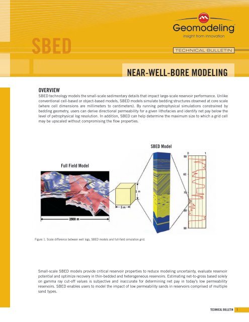
SBED Model<br />
Full Field Model<br />
Figure 1. Scale difference between well logs, SBED models and full-field simulation grid.<br />
Small-scale SBED models provide critical reservoir properties to reduce modeling uncertainty, evaluate reservoir<br />
potential and optimize recovery in thin-bedded and heterogeneous reservoirs. Estimating net-to-gross based solely<br />
on gamma ray cut-off values is subjective and inaccurate for determining net pay in today’s low permeability<br />
reservoirs. SBED enables users to model the impact of low permeability sands in reservoirs comprised of multiple<br />
sand types.<br />
TECHNICAL BULLETIN 1
SBED MODELING WORKFLOW<br />
• Identify representative lithofacies intervals by evaluating core, lithology description or borehole images.<br />
• Compile petrophysical statistics such as porosity, permeability and net-to-gross (sand/shale) ratio for each identified<br />
facies.<br />
• For each defined interval, generate bedding structure models using built-in SBED stratigraphic templates.<br />
• Populate bedding structure models with porosity, permeability and saturation data. Generate realizations of porosity and<br />
permeability grids.<br />
• Stack bedding structure models to simulate a depositional facies (e.g. channel, turbidite) over the entire cored interval.<br />
• Upscale the stacked model to calculate effective porosity, horizontal permeability, vertical permeability, relative<br />
permeability, oil/gas/water saturation and net-to-gross ratio.<br />
• Export upscaled SBED geometry and property grids into third-party reservoir simulators to evaluate reservoir quality and<br />
associated uncertainties.<br />
Figure 2. SBED modeling workflow.<br />
2 NEAR-WELL-BORE MODELING
REALISTIC BEDDING STRUCTURE MODELS<br />
SBED generates geological models by mimicking the processes<br />
involved in the formation of sedimentary bedding, such as<br />
bedform migration, erosion and deposition. Formulated in<br />
a stochastic framework, the modeling algorithms generate<br />
accurate 3D geological models and simulate petrophysical<br />
properties that are constrained by bedding geometry.<br />
Cross Bedding Model<br />
Wavy Unidirectional Model<br />
Figure 3. SBED models mimic sedimentary bedding structures that are seen in core and outcrop.<br />
DIGITAL ROCK LIBRARY<br />
• Access more than 100 built-in<br />
stratigraphic templates to quickly and<br />
accurately model a wide variety of<br />
depositional environments, including<br />
estuarine, shoreface and submarine fan<br />
environments.<br />
• Customize models using the template<br />
library to solve any geologic problem.<br />
• Edit bedding geometry, bedform<br />
orientation and boundary conditions to<br />
represent core and outcrop<br />
observations.<br />
• Input lithological and petrophysical<br />
parameters such as sand/shale<br />
ratio, porosity and permeability.<br />
Figure 4. SBED stratigraphic templates can be stacked to model depositional<br />
environments observed in outcrop and core.<br />
TECHNICAL BULLETIN 3
IMPROVED PROPERTY MODELING<br />
• Input porosity, permeability and water saturation data from core plug and well log analysis.<br />
• Plot the relationship between vertical permeability (k v ) and horizontal permeability (k h ) in SBED models.<br />
• Derive accurate facies-dependent effective porosity and permeability (k v /k h ) distributions to reduce uncertainty.<br />
• Simulate multiple geological scenarios to understand how sedimentary structures impact fluid flow.<br />
• Generate effective property values for input to larger-scale reservoir property models.<br />
A. B.<br />
Figure 5. Comparison of permeability<br />
values for two scenarios with 100%<br />
net-to-gross: (A) interval of two high<br />
permeability sands, (B) interval<br />
containing high and low permeability<br />
sand. Scenario (B) generates permeability<br />
values that are much lower than<br />
scenario (A) and illustrates the effect of<br />
low permeability sand on flow<br />
characteristics.<br />
SBED can have a dramatic impact on reserve estimation in reservoirs such as thinly bedded sands or shale-dominated,<br />
basin-centered gas plays by revealing net pay below the level of petrophysical log resolution.<br />
SBED offers petrophysical characterization that is superior to simple net-to-gross estimation by providing flow-based reservoir<br />
modeling that accurately reflects sedimentary depositional processes.<br />
4 NEAR-WELL-BORE MODELING<br />
www.geomodeling.com<br />
SBED is revolutionary software for small-scale (centimeter- to meter-scale) geological<br />
heterogeneity modeling and upscaling. The software provides detailed 3D geological<br />
models for input to reservoir simulators and generates petrophysical models that<br />
honor sedimentary processes. As a plug-in to reservoir interpretation workflows, SBED<br />
enables asset teams to identify thin bed potential, understand its impact on recoverable<br />
reserves, and choose optimal depletion strategies.<br />
© 2006 Geomodeling Technology Corp.<br />
Printed in Canada