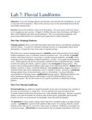
Lab 10: Glacial Features and Interpretation of Air Photos - Classes
Lab 10: Glacial Features and Interpretation of Air Photos - Classes
Lab 10: Glacial Features and Interpretation of Air Photos - Classes

Create successful ePaper yourself
Turn your PDF publications into a flip-book with our unique Google optimized e-Paper software.
Name: __________________<br />
<strong>Lab</strong> <strong>10</strong>: <strong>Glacial</strong> <strong>Features</strong> <strong>and</strong> <strong>Interpretation</strong> <strong>of</strong> <strong>Air</strong> <strong>Photos</strong><br />
Objectives: To learn to recognize, analyze, <strong>and</strong> interpret glacial l<strong>and</strong>forms, <strong>and</strong> to learn<br />
to map these l<strong>and</strong>forms using aerial photographs <strong>and</strong> topographic maps.<br />
Part 1: Identifying l<strong>and</strong>forms produced by alpine glaciation<br />
Questions using the Rocky Mountain National Park 1:125,000 map:<br />
1. What glacial feature is represented by Windy Gulch (about 7 miles west <strong>of</strong> Estes<br />
Park) How did it form<br />
2. a) Through the center <strong>of</strong> the park, the Continental Divide runs NW to SE. Which side<br />
<strong>of</strong> the divide shows more evidence <strong>of</strong> current glacial activity<br />
b) Was this also true in the past What is your evidence<br />
c) Why does this phenomenon occur<br />
Use the McHenry’s Peak 1:24,000 topographic map to answer the following questions:<br />
3. Locate one good example <strong>of</strong> each <strong>of</strong> the glacial features mentioned below, <strong>and</strong> clearly<br />
indicate its name or location:<br />
a) Cirque:<br />
b) Arete:<br />
c) Col:<br />
d) Horn:<br />
e) Tarn:<br />
f) Paternoster lakes:<br />
g) Hanging valley:<br />
Questions using the Mount Rainier, Washington 1:125,000 topographic map:
4. Notice the asymmetry in the size <strong>and</strong> location <strong>of</strong> glaciers around the summit. Why<br />
would this occur<br />
5. a) Look carefully at the trough in which the White River flows. Does it appear that<br />
the Emmons glacier once extended further down the valley than presently<br />
b) Give two pieces <strong>of</strong> topographic evidence for your answer to part a.<br />
6. a) What are the channel patterns <strong>of</strong> the White River, the West Fork White River, <strong>and</strong><br />
the Carbon River<br />
b) List two reasons for this channel pattern to occur.<br />
Questions using the Holy Cross, Colorado 1:62,500 topographic map.<br />
7. a) What glacial feature is responsible for the impoundment <strong>of</strong> Turquoise Lake<br />
b) What might account for the pockmarked appearance <strong>of</strong> the surface <strong>of</strong> this feature
Part 2: Identifying l<strong>and</strong>forms produced by continental glaciation<br />
Questions using the Jackson, Michigan 1:62,500 topographic map:<br />
1. What is the name for the lakes which occur in the numerous depressions on this map<br />
2. a) What glacial feature is represented by Blue Ridge<br />
b) Explain how this feature formed.<br />
Questions using the Ayer, Mass 1:24,000 topographic map:<br />
1. a) Oak Hill is composed <strong>of</strong> bedrock, but the smaller hills to the north are not. What<br />
are these features<br />
b) What are they composed <strong>of</strong><br />
2. a) What direction did the ice move in this area<br />
b) What is your evidence<br />
Part 3: Mapping glacial topography in the Cache la Poudre River<br />
During the height <strong>of</strong> the Pleistocene, alpine glaciers mantled most <strong>of</strong> the western<br />
mountain ranges north <strong>of</strong> 35 degrees latitude. Pale remnants <strong>of</strong> the Pleistocene glaciers<br />
remain today, but the effect <strong>of</strong> the glacial epoch is amply recorded in many terrains.<br />
The goal <strong>of</strong> this problem is to familiarize you with a number <strong>of</strong> glacier-related l<strong>and</strong>forms<br />
near CSU. Using the aerial photographs provided in lab, consider the glacial history <strong>of</strong><br />
the Cache la Poudre River. DO NOT SCRATCH OR MANGLE THE AERIAL PHOTOGRAPHS<br />
IN ANY WAY, AND DO NOT REMOVE THE PROTECTIVE PLASTIC COVERS!
1. By examining the aerial photographs, locate <strong>and</strong> color-code each <strong>of</strong> the following<br />
l<strong>and</strong>forms on the attached photocopies <strong>of</strong> the Kinikinik, CO 7.5 minute topographic<br />
quadrangle. Be sure to include a color-coded key with your map (the colors below<br />
are just suggested colors).<br />
Limit <strong>of</strong> glaciation = black line<br />
Floor <strong>of</strong> main glacial trough = dark blue<br />
Floor <strong>of</strong> hanging valley = light blue<br />
Bedrock = orange<br />
Lateral moraine = brown<br />
Terminal moraine = yellow<br />
Alluvial fans = green<br />
River terraces = red<br />
2. Select 2 locations that you would examine during a field visit, mark each with a red<br />
dot, <strong>and</strong> number them 1 <strong>and</strong> 2. These should be areas where you are uncertain <strong>of</strong> the<br />
origin <strong>of</strong> a specific feature.<br />
3. Based on the aerial photos <strong>and</strong> the topographic map, describe your preliminary ideas<br />
about the origins <strong>of</strong> each feature chosen in question 2. What specific characteristics<br />
do you expect to find in the field if your assessments are correct (morphology, deposit<br />
characteristics, etc.) Use the space below.<br />
Location #1<br />
Location #2
4. a) Measure <strong>and</strong> compare the sinuosity <strong>of</strong> the Cache la Poudre River upstream <strong>and</strong><br />
downstream <strong>of</strong> the “X” marked on the photocopied map. Show work!<br />
Upstream ______<br />
Downstream ______<br />
b) Measure the slope (in feet per mile) <strong>of</strong> the Cache la Poudre River upstream <strong>and</strong><br />
downstream <strong>of</strong> the X (measure from the X to the edge <strong>of</strong> the map). Show work!<br />
c) How does slope affect the sinuosity <strong>of</strong> the river in this area<br />
Upstream ______<br />
Downstream ______<br />
d) Considering your answer to c, describe how glacial activity has affected the reach<br />
<strong>of</strong> the Poudre River shown on the photocopied map. Be sure to consider rates <strong>of</strong><br />
lateral erosion <strong>and</strong> incision, as well as floodplain attenuation.<br />
e) What factors do you think controlled the extent <strong>of</strong> glaciation in the Cache la<br />
Poudre River valley (ie, why did the glaciers stop where they did)
Part 4: Analyzing the Cache la Poudre Valley Morphology<br />
1. Find transects A-A′ <strong>and</strong> B-B′ on the photocopy <strong>of</strong> the Kinikinik, CO quadrangle. Plot<br />
a cross-section for each transect in Excel or on regular graph paper. Use the<br />
following guidelines:<br />
a) Include enough contour lines to accurately portray the shape <strong>of</strong> each cross<br />
section (ie, include more than just the index contours).<br />
b) Plot both cross-sections on a single graph.<br />
c) Use the center <strong>of</strong> the river as the origin for both axes. In other words, set the<br />
elevation <strong>of</strong> the river as zero, <strong>and</strong> measure the distance <strong>of</strong> each contour line<br />
from the river—positive distances to the north <strong>and</strong> negative distances to the<br />
south. The 2 cross sections should then line up for direct comparison.<br />
d) Use a vertical exaggeration <strong>of</strong> <strong>10</strong> times (i.e., <strong>10</strong> units on the y-axis should be<br />
the same length as <strong>10</strong>0 units on the x-axis.)<br />
e) Include a descriptive title, label each axis, <strong>and</strong> label each cross section.<br />
2. Use the cross-sections to measure the cross-sectional area eroded by fluvial processes<br />
<strong>and</strong> the cross-sectional area eroded by glacial processes. To do this, assume that the<br />
valley floor was exactly horizontal at 500 feet above the river prior to glacial <strong>and</strong><br />
fluvial erosion. Calculate the area by parceling the cross sectional areas into simpler<br />
geometric shapes. Be sure to take into account the exaggeration <strong>of</strong> the y-axis.<br />
3. a) According to the areas calculated above, which process -- glacial or fluvial --<br />
appears to have been the more effective erosive agent in the Cache la Poudre River<br />
b) What is the ratio <strong>of</strong> the amount <strong>of</strong> glacial erosion to the amount <strong>of</strong> fluvial erosion<br />
4. Discuss the assumptions involved in this method <strong>of</strong> calculation <strong>and</strong> whether they<br />
appear valid here.<br />
5. Briefly describe <strong>and</strong> compare the morphologic processes that were involved in<br />
creating the two distinct morphologies represented by your cross sections.