Pontcysyllte Aqueduct Conservation Area Assessment and ...
Pontcysyllte Aqueduct Conservation Area Assessment and ...
Pontcysyllte Aqueduct Conservation Area Assessment and ...

You also want an ePaper? Increase the reach of your titles
YUMPU automatically turns print PDFs into web optimized ePapers that Google loves.
<strong>Pontcysyllte</strong> <strong>Aqueduct</strong><br />
<strong>Conservation</strong> <strong>Area</strong> <strong>Assessment</strong><br />
<strong>and</strong> Management Plan<br />
July 2009
Contact<br />
For more information or advice contact:<br />
Chief Planning Officer<br />
Planning Department<br />
Wrexham County Borough Council<br />
Lambpit Street<br />
Wrexham<br />
LL11 1AR<br />
Telephone: 01978 292019<br />
email: planning@wrexham.gov.uk<br />
www.wrexham.gov.uk/planning<br />
This document is available in welsh <strong>and</strong> in alternative formats on<br />
request. It is also available on the Council’s website
Contents <br />
Part I - Character <strong>Assessment</strong> 1<br />
1.0 Introduction 3<br />
2.0 Origins <strong>and</strong> Development 5<br />
3.0 Summary of Special Character 9<br />
4.0 Character <strong>Area</strong>s 13<br />
5.0 Summary of Negative Features 22<br />
Part II - Management Plan 25<br />
6.0 Enhancement Plan 26<br />
7.0 Design Guidance 29<br />
8.0 <strong>Conservation</strong> <strong>Area</strong> Controls 31<br />
9.0 Sources of Funding 33<br />
Appendix 1 34<br />
Listed Buildings<br />
Appendix 2 35<br />
<strong>Conservation</strong> Policy Guidance<br />
Appendix 3 36<br />
Glossary of Architectural Terms<br />
Figures<br />
Figure 1 <strong>Pontcysyllte</strong> <strong>Aqueduct</strong> <strong>Conservation</strong> <strong>Area</strong> 2<br />
Figure 2 <strong>Pontcysyllte</strong>, Trevor Basin <strong>and</strong> Trevor Wharfs 1875 6<br />
Figure 3 Froncysyllte Basin 1877 7<br />
Figure 4 <strong>Conservation</strong> <strong>Area</strong> Character <strong>Area</strong>s 12<br />
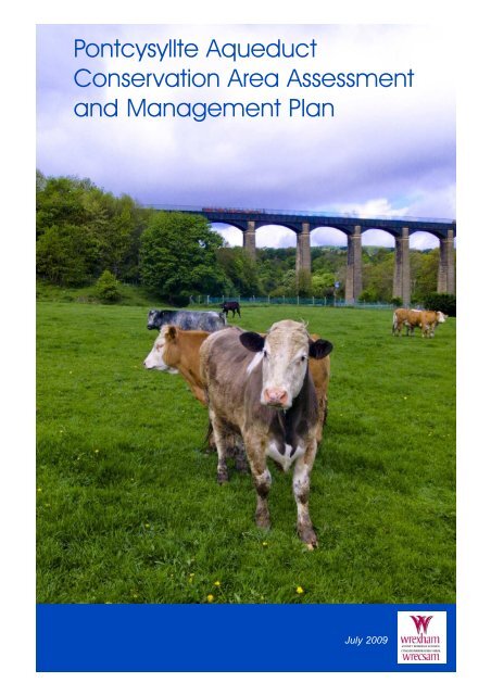
Figure 5 <strong>Pontcysyllte</strong> <strong>Aqueduct</strong> 14<br />
Figure 6 Trevor Wharf 16<br />
Figure 7 The North Wharves 19<br />
Figure 8 Froncysyllte Basin 21
Part I<br />
<br />
Character <strong>Assessment</strong><br />
<br />
1
character assessment<br />
<br />
Ordnance Survey (mapping) © Crown copyright. All rights reserved. 100023429. 2007<br />
Figure 1 - <strong>Pontcysyllte</strong> <strong>Aqueduct</strong> <strong>Conservation</strong> <strong>Area</strong> <br />
2
introduction<br />
<br />
<strong>Conservation</strong> <strong>Area</strong> Designation<br />
1.1 Section 69 of the Planning (Listed Buildings <strong>and</strong><br />
<strong>Conservation</strong> <strong>Area</strong>s) Act 1990 requires Local Authorities to<br />
identify "areas of special architectural or historic interest the<br />
character or appearance of which it is desirable to preserve<br />
or enhance" for designation as conservation areas.<br />
Purpose<br />
1.2 The purpose of the <strong>Conservation</strong> <strong>Area</strong> <strong>Assessment</strong><br />
<strong>and</strong> Management Plan is:<br />
● To provide a clear definition of an area's special<br />
architectural or historic interest<br />
● To identify ways in which their unique<br />
characteristics can be preserved <strong>and</strong> enhanced<br />
through the Enhancement Plan<br />
● To strengthen the justification for designation<br />
● To create a clear context for future development in<br />
accordance with conservation area policies in the<br />
development plan<br />
● To provide a vehicle for engagement <strong>and</strong> awareness<br />
raising<br />
<strong>Pontcysyllte</strong> <strong>Aqueduct</strong><br />
<strong>Conservation</strong> <strong>Area</strong><br />
1.3 The <strong>Assessment</strong> <strong>and</strong> Management Plan aims to<br />
promote <strong>and</strong> support developments that are in keeping with,<br />
or enhance, the character of the <strong>Pontcysyllte</strong> <strong>Aqueduct</strong><br />
<strong>Conservation</strong> <strong>Area</strong>. It is not an attempt to stifle change. The<br />
aim is to strike a balance so that the interests of conservation<br />
are given their full weight against the needs for change <strong>and</strong><br />
development. The Trevor Basin <strong>Conservation</strong> <strong>Area</strong> was<br />
designated on the 6th July 1998 <strong>and</strong> extended <strong>and</strong> renamed<br />
the <strong>Pontcysyllte</strong> <strong>Aqueduct</strong> <strong>Conservation</strong> <strong>Area</strong> on 14th July<br />
1 Introduction <br />
2009. This document is concerned with the reasons for<br />
designation, defining the qualities that make up its special<br />
architectural <strong>and</strong> historic interest, character <strong>and</strong> appearance.<br />
The omission of any building, feature or space should not be<br />
taken to imply that it is of no interest.<br />
<strong>Pontcysyllte</strong> <strong>Aqueduct</strong> <strong>and</strong> Canal<br />
World Heritage Site<br />
1.4 The <strong>Pontcysyllte</strong> <strong>Aqueduct</strong> <strong>and</strong> Canal was designated a<br />
UNESCO World Heritage Site in June 2009. It is recognised<br />
for its outst<strong>and</strong>ing universal value as a masterpiece of canal<br />
engineering <strong>and</strong> an outst<strong>and</strong>ing representation of the<br />
improvement of transport during the Industrial Revolution.<br />
The World Heritage Site is 11 miles long from the Gledrid<br />
Bridge in Shropshire to the Horseshoe falls in Denbighshire.<br />
Planning Context<br />
1.5 This document should be read in conjunction with the<br />
adopted Wrexham Unitary Development Plan 2005, <strong>and</strong><br />
national planning policy guidance, in particular Welsh Office<br />
Circular 61/96 Planning <strong>and</strong> the Historic Environment:<br />
Historic Buildings <strong>and</strong> <strong>Conservation</strong> <strong>Area</strong>s.<br />
Trevor Basin <strong>Conservation</strong> <strong>Area</strong><br />
Character Appraisal<br />
1.6 The <strong>Pontcysyllte</strong> <strong>Conservation</strong> <strong>Area</strong> Character<br />
<strong>Assessment</strong> <strong>and</strong> Management Plan will replace this<br />
document. Since published in April 2001 the <strong>Conservation</strong><br />
<strong>Area</strong> has experienced significant improvement, in particular<br />
through a conservation programme run during 2003-04,<br />
which saw the refurbishment of the <strong>Pontcysyllte</strong> <strong>Aqueduct</strong>.<br />
Location<br />
1.7 The <strong>Pontcysyllte</strong> <strong>Aqueduct</strong> <strong>Conservation</strong> <strong>Area</strong> extends<br />
from the Llangollen canal Trevor Basin terminus in the<br />
3
settlement of <strong>Pontcysyllte</strong>, southwards as far as the<br />
settlement of Froncysyllte. It is located to the south west of<br />
Trevor, 6 miles south of Wrexham <strong>and</strong> 3 miles east of<br />
Llangollen. The historic A5 route from London to<br />
Holyhead, constructed by Thomas Telford, runs to the south,<br />
through the village of Froncysyllte. To the north is the A539<br />
road to Ruabon, <strong>and</strong> the settlement of Trevor. The most<br />
prominent structure is the <strong>Pontcysyllte</strong> <strong>Aqueduct</strong>.<br />
1.8 The <strong>Conservation</strong> <strong>Area</strong> is linear in form with its axis<br />
aligned approximately North - South. It incorporates key<br />
structures important in the canal development of the Basin<br />
<strong>and</strong> is clearly different from the areas of 20th Century<br />
housing adjacent to<br />
the North <strong>and</strong><br />
South ends. It<br />
includes the<br />
essential setting of<br />
the <strong>Aqueduct</strong>, the<br />
approach<br />
embankment <strong>and</strong><br />
buildings<br />
associated with<br />
them.<br />
introduction <br />
4
origins <strong>and</strong> development<br />
<br />
2 Origins <strong>and</strong> Development<br />
<br />
2.1 <strong>Pontcysyllte</strong> <strong>Aqueduct</strong> was constructed to carry the<br />
Ellesmere (now Llangollen) canal. The canal was cut in<br />
response to the 'Canal Mania' years of the early 1790's; it<br />
was promoted as a necessary requirement for the expansion<br />
of the ironworks, collieries <strong>and</strong> associated industries within<br />
the Ruabon <strong>and</strong> Wrexham district.Development within<br />
Trevor Basin, was largely confined to the period between<br />
1795 to the early 1880's.<br />
2.2 The initial Ellesmere Canal Scheme promoted in the<br />
Act of Parliament in 1793 was one of the most ambitious<br />
ever devised. It planned to link the Mersey (at what was to<br />
become Ellesmere Port) with the Dee at Chester, Wrexham,<br />
<strong>and</strong> the North Wales Coalfield, the Shropshire town of<br />
Ellesmere, <strong>and</strong> eventually with the Severn at Shrewsbury.<br />
This followed considerable debate as to the most suitable<br />
route. One party favoured a Mersey-Dee line, while the<br />
other a Dee-Severn line. <strong>Pontcysyllte</strong> <strong>Aqueduct</strong> was a vital<br />
feature in both schemes as a strategic crossing point in the<br />
valley of the Dee.<br />
2.3 Following the 1793 Act, Thomas Telford was<br />
appointed General Agent to the Ellesmere Canal Company,<br />
with William Jessop as Engineer, assisted by John<br />
Duncombe, Thomas Densom <strong>and</strong> William Turner. Jessop<br />
was one of the most important canal <strong>and</strong> dock engineers of<br />
the day. Telford was then a little known county surveyor,<br />
who was to become one of the most prolific engineers of<br />
the early 19th Century.<br />
2.4 The 'main line' of the Ellesmere Canal ran from<br />
Trevor to Welsh Frankton where it was split into different<br />
branches. The Trevor Section was begun in 1793-4 with<br />
Jessop <strong>and</strong> Telford designing the aqueducts at <strong>Pontcysyllte</strong><br />
in 1795 (completed in 1805) <strong>and</strong> at Chirk (opened in 1801).<br />
The construction of the aqueduct was well under way when<br />
the intended main line from Trevor to the Dee was<br />
ab<strong>and</strong>oned in 1800. The original purpose of the aqueduct<br />
on a through route was replaced simply by that of giving<br />
access to the terminus <strong>and</strong> to a branch <strong>and</strong> water feeder<br />
from Llangollen.<br />
2.5 A fragment of the canal, the Ffrwd branch was also<br />
constructed, <strong>and</strong> the industrial district around Trevor<br />
became the effective terminus of a southerly route from<br />
Chester via Nantwich <strong>and</strong> Whitchurch. It was linked to<br />
local industries by tramroads <strong>and</strong> by a short canal (opened<br />
in 1830) to the Plas Kynaston ironworks. In the years<br />
between 1801 <strong>and</strong> 1808 Bridge 31 was built. Plans were<br />
prepared in 1803 for the feeder canal from Llantysilio to the<br />
West of <strong>Pontcysyllte</strong>. In 1808 a navigable feeder canal was<br />
cut from Trevor to the Dee at Llantysilio. This supplied the<br />
system with water abstracted from the River Dee at the<br />
Horseshoe Falls, a weir constructed for that purpose.<br />
2.6 Prior to this, the site was undeveloped. Canal<br />
Company maps of 1793 <strong>and</strong> 1795 show no houses on the<br />
north side of the Dee at Trevor, although New Road is<br />
shown to be existing at this time. The origins of Trevor<br />
Basin thus owe its origin to the canal.<br />
2.7 An 1803 plan shows the New Road Bridge <strong>and</strong> a<br />
building thought to have been built by the Ellesmere Canal<br />
Company as a residence for Telford's supervising engineer<br />
for the construction of the canal <strong>and</strong> aqueduct. It was later<br />
called Scotch Hall <strong>and</strong> is now called Telford's Inn, <strong>and</strong><br />
"erected at the north end of the aqueduct in a corner of a<br />
field of stone, lime <strong>and</strong> s<strong>and</strong>, as well as timber". The<br />
tramway linking Trevor Basin with the Plas Kynaston<br />
industries was gradually extended northwards to Ruabon<br />
5
origins <strong>and</strong> development <br />
Figure 2 <strong>Pontcysyllte</strong>, Trevor Basin <strong>and</strong> Trevor Wharfs 1875<br />
Brook. The canal provided transport to the slate quarries<br />
<strong>and</strong> limestone works. Plas Kynaston ironworks provided<br />
material for the construction of the aqueduct. Meanwhile at<br />
Froncysyllte, the basin provided a terminus for the canal<br />
whilst the <strong>Aqueduct</strong> was being completed, with trading<br />
from the adjacent canal wharf. At this time no buildings are<br />
shown to exist in this area.<br />
2.8 By the time of the 1838 Tithe Survey, Trevor Basin<br />
had taken on some of its present appearance. The survey<br />
shows the twin dry docks, constructed some time between<br />
1803 - 1838, on the east-side of the canal. These became<br />
the termini of the main canal. Dock Cottage dates from the<br />
same period, as does the single storey building immediately<br />
east of Telford Inn, which was probably an outbuilding for<br />
Scotch Hall.<br />
2.9 The 1st Edition Ordnance Survey 1:2500 Map of 1875<br />
shows a single-storey, brick workshop at the south of the<br />
dry docks had been constructed <strong>and</strong> the northernmost dry<br />
dock covered. The western side of the Basin on both sides<br />
of the New Road Bridge is indicated by a network of rails<br />
that ran the length of the pier to the northern end of the<br />
Basin. At Froncysyllte, Fron House, Argoed Lodge <strong>and</strong><br />
Froncysyllte Institute were developed. By the 2nd edition<br />
OS Map of 1899 a covered transhipment shed in the north<br />
east corner of the rail / canal area at Trevor Basin <strong>and</strong> at<br />
Froncysyllte, Canal House, a lengthmans cottage <strong>and</strong> Canal<br />
Terrace had been constructed. The 3rd edition OS Map of<br />
1912 shows a large C-plan building close to the New Road<br />
Bridge at Trevor.<br />
2.10 Later 20th Century development was minor <strong>and</strong><br />
included the demolition of extensions to Dock Cottage <strong>and</strong><br />
the erection of the Anglo-Welsh shop <strong>and</strong> the construction<br />
of the Basin footbridge at Trevor Basin whilst at<br />
Froncysyllte, a row of bungalows were built alongside the<br />
basin, Coedfryn. The Fron Lifting Bridge, dated early 19th<br />
Century, was replaced in a similar form to the original.<br />
6
origins <strong>and</strong> development <br />
Figure 3 Froncysyllte Basin 1877<br />
7
8<br />
origins <strong>and</strong> development
summary of special character<br />
<br />
3.1 The special character of the <strong>Pontcysyllte</strong> <strong>Aqueduct</strong><br />
<strong>Conservation</strong> <strong>Area</strong> is derived from the following:<br />
<strong>Pontcysyllte</strong> <strong>Aqueduct</strong> <strong>and</strong> its<br />
L<strong>and</strong>scape Setting<br />
3.2 The aqueduct is the<br />
dominant, physical,<br />
architectural <strong>and</strong> historic<br />
element of the <strong>Conservation</strong><br />
<strong>Area</strong>. A remarkable example<br />
of working industrial<br />
heritage; its size, scale <strong>and</strong><br />
structural daring through a<br />
picturesque l<strong>and</strong>scape have<br />
been a source of wonder since<br />
the 1790's.<br />
Contribution Made<br />
by Trees<br />
3.3 A strong sense of enclosure is afforded by the wooded<br />
embankments adjacent to the <strong>Aqueduct</strong> <strong>and</strong> alongside the<br />
linear route from the Froncysyllte Basin to the <strong>Aqueduct</strong>.<br />
These woodl<strong>and</strong>s provide a backdrop to the <strong>Conservation</strong><br />
<strong>Area</strong> <strong>and</strong><br />
form a buffer<br />
between the<br />
<strong>Conservation</strong><br />
<strong>Area</strong> <strong>and</strong> the<br />
adjacent<br />
areas of<br />
urban<br />
housing <strong>and</strong><br />
industry.<br />
3 Summary of Special Character<br />
<br />
Contrast Between Open <strong>and</strong> Enclosed<br />
Spaces<br />
3.4 The open<br />
aspect from the<br />
<strong>Aqueduct</strong> <strong>and</strong> Dee<br />
Valley floor is in<br />
direct contrast with<br />
the tree-enclosed<br />
pathways on its<br />
approach to the most<br />
dominant feature of<br />
the <strong>Conservation</strong><br />
<strong>Area</strong>. From the open fields of the Valley floor the sheer<br />
scale of the <strong>Aqueduct</strong> can be appreciated. Further contrast is<br />
made between the unplanned <strong>and</strong> open l<strong>and</strong>scape of the Dee<br />
Valley with the strong linear form of the <strong>Aqueduct</strong> <strong>and</strong> its<br />
enclosure of water <strong>and</strong> pathways.<br />
Important Views<br />
3.5 Significant views of the <strong>Aqueduct</strong> are obtained from<br />
the Valley floor as<br />
well as along its<br />
length from Trevor<br />
Basin. From<br />
Froncysyllte Basin,<br />
magnificent views<br />
can be obtained up<br />
the Vale of<br />
Llangollen whilst<br />
from the <strong>Aqueduct</strong><br />
itself, panoramic<br />
views of the Dee<br />
Valley can be<br />
appreciated.<br />
9
Cefn Stone<br />
3.6 The yellow Cefn s<strong>and</strong>stone is the predominant material<br />
within the <strong>Conservation</strong> <strong>Area</strong>, used in the construction of the<br />
<strong>Aqueduct</strong> itself as well as associated canal bridges, buildings<br />
<strong>and</strong> boundary walls.<br />
Canal Structures<br />
3.7 The structures <strong>and</strong> associated buildings create focal<br />
points along the length of the canal <strong>and</strong> within the<br />
<strong>Conservation</strong> <strong>Area</strong>. In particular the Trevor Basin Dry<br />
Docks swivel bridge, Scotch Hall Bridge <strong>and</strong> the<br />
Froncysyllte Lifting Bridge link the network of footpaths<br />
<strong>and</strong> spaces throughout the area.<br />
summary of special character <br />
10
summary of special character <br />
11
summary of special character<br />
<br />
The North Wharves<br />
Trevor Wharf<br />
<strong>Pontcysyllte</strong> <strong>Aqueduct</strong><br />
Froncysyllte Basin<br />
Ordnance Survey (mapping) © Crown copyright. All rights reserved. 100023429. 2007<br />
Figure 4 <strong>Conservation</strong> <strong>Area</strong> Character <strong>Area</strong>s <br />
12
character areas <br />
4.1 The <strong>Conservation</strong> <strong>Area</strong> can be divided into 4 distinct<br />
areas of character as identified on figure 4 <strong>and</strong> now<br />
described below:<br />
4.2 The aqueduct, a<br />
Grade I Listed Building,<br />
dominates the<br />
<strong>Conservation</strong> <strong>Area</strong>.<br />
LTC Rolt refers to<br />
<strong>Pontcysyllte</strong> as 'one of<br />
the great engineering<br />
achievements of all time'.<br />
The l<strong>and</strong>scape of the valley<br />
<strong>and</strong> the River Dee is largely<br />
unspoilt by development <strong>and</strong> from<br />
here the true gr<strong>and</strong>eur <strong>and</strong> achievement of the<br />
aqueduct can be appreciated. An icon of the<br />
Canal Age <strong>and</strong> the Industrial Revolution, a<br />
trough constructed of pre-cast iron flanged <strong>and</strong><br />
bolted plates carries the canal 38.4m/126ft above<br />
the valley floor. The towpath is cantilevered over<br />
the trough <strong>and</strong> the aqueduct is carried on 18 tapering<br />
stone piers. The embankments afford awe-inspiring views<br />
of the <strong>Aqueduct</strong> including the cast iron supporting ribs <strong>and</strong><br />
fine curved ashlar stone abutment walls. Sir Walter Scott<br />
described it as the " stream in the sky". It was the subject<br />
of numerous engravings in the 19th Century <strong>and</strong> a source of<br />
wonder to travellers.<br />
4.3 The aspect along the aqueduct is awe-inspiring, <strong>and</strong><br />
the realisation of the slenderness of the structure at this<br />
height leads to an underst<strong>and</strong>ing of the construction skills<br />
<strong>and</strong> craftsmanship of the time. Looking down to the River<br />
Dee below enables the magnitude of this structure to be<br />
appreciated. There are also fine views of the Dee valley,<br />
enclosed by glacial ridges. To the west, is an historic road<br />
bridge over the River Dee, Pont Cysylltau - a Grade I<br />
4 Character <strong>Area</strong>s<br />
<strong>Pontcysyllte</strong> <strong>Aqueduct</strong><br />
Listed Building <strong>and</strong> Scheduled Ancient Monument dating<br />
from 1697, built of ashlar, yellow s<strong>and</strong>stone. Glimpses of<br />
fine Georgian <strong>and</strong> Victorian properties within the tree-scape<br />
complement this view. One such building is Wood Bank,<br />
the Grade II listed, late 18th Century Georgian<br />
villa reputed to be Telford's drawing office<br />
during the construction of the canal <strong>and</strong><br />
aqueduct.<br />
4.4 At the North end, development<br />
immediately below the aqueduct to<br />
the west is of two detached houses.<br />
They can be viewed easily from its<br />
vantage point.<br />
4.5 The view to the east includes the<br />
yellow s<strong>and</strong>stone viaduct at<br />
Newbridge, a Grade II* Listed structure<br />
built in 1848 - 9 for the Shrewsbury <strong>and</strong><br />
Chester railway.<br />
4.6 Trees provide a vitally important component to the<br />
character of the area.<br />
13
character areas <br />
Figure 5 <strong>Pontcysyllte</strong> <strong>Aqueduct</strong><br />
Sub area boundary<br />
Listed Building<br />
Tree Preservation Order<br />
Strong Enclosure by Trees<br />
Important View<br />
14
character areas<br />
<br />
4.7 This is a most attractive area characterised by ashlar<br />
<strong>and</strong> rubble<br />
yellow Cefn<br />
s<strong>and</strong>stone<br />
bridges,<br />
boundary<br />
walling, <strong>and</strong><br />
buildings, all in<br />
sharp contrast<br />
to the rather<br />
ordinary red<br />
brick <strong>and</strong><br />
render housing along the approach roads. To the west <strong>and</strong><br />
north the attractive stone walls give a unity to the area as<br />
well as defining the space.<br />
4.8 There are few buildings in this area. The Telford Inn<br />
<strong>and</strong> the adjacent cottage in the north west corner of the area<br />
comprise a strong group in a key position. Very visible<br />
when<br />
approaching the<br />
site by road, the<br />
buildings<br />
contrast with<br />
their immediate<br />
surroundings.<br />
Prominent on<br />
the roadside<br />
above the stone<br />
walls are the<br />
shallow roofs with large overhanging eaves <strong>and</strong> gables<br />
characteristic of late 18th Century buildings. The buildings<br />
Trevor Wharf<br />
<br />
are of good proportion <strong>and</strong> simply detailed, finished in<br />
white painted stucco with details picked out in black.<br />
4.9 With the Telford Inn flanked on one side by the<br />
cottage <strong>and</strong> on the other side by outbuildings finished in a<br />
similar manner, the group forms an attractive backdrop<br />
when viewed from the canal wharf. They are also<br />
prominent when viewed from the aqueduct's towpath. This<br />
is a valuable asset, as to the northeast <strong>and</strong> east the views<br />
from the centre of this area are of industrial development.<br />
4.10 The Telford Inn is the only building to be constructed<br />
at Trevor Basin before 1803. It has been altered in the 19th<br />
<strong>and</strong> 20th Centuries. The symmetrical proportions <strong>and</strong><br />
overhanging hipped roof are typical of buildings belonging<br />
to the canal age.<br />
4.11 The single storey cottage to the south east of Telford<br />
Inn appears to date from the period 1803-38. It was<br />
associated with Scotch Hall (Telford Inn) <strong>and</strong> was modified<br />
in 1897 at which date it was referred to as the Agent's<br />
Office, presumably of the Ellesmere Canal Company. It<br />
may have been used as a counting house to pay wages to<br />
the workers building the aqueduct.<br />
4.12 At the west side of the canal, further south of the Inn<br />
is The Anglo Welsh shop owned by the Turnpike Trust.<br />
The origin of this may be a former canal warehouse. By<br />
1903 it had been converted into a stable, which was likely<br />
to have served Scotch Hall, now Telford Inn. The building<br />
has been much altered over the years <strong>and</strong> is a mixture of<br />
building materials, ranging from the original, roughly<br />
dressed, yellow s<strong>and</strong>stone to include some red <strong>and</strong> blue<br />
15
character areas <br />
Figure 6 Trevor Wharf<br />
Sub area boundary<br />
Listed Building<br />
Tree Preservation Order<br />
Building/Structure of Visual Interest<br />
Strong Enclosure by Trees<br />
Important stretch of Stone Boundary<br />
Strong Enclosure by Natural L<strong>and</strong>scape<br />
brick, with a<br />
pitched, grey<br />
felt roof <strong>and</strong><br />
modern wooden<br />
casement<br />
windows. The<br />
building is of<br />
two storeys <strong>and</strong><br />
the upper storey<br />
has one opening<br />
to the north<br />
west, where the gable is built into the Basin's perimeter<br />
wall, <strong>and</strong> another to the north east. The former opening<br />
functioned as a 'taking in' door <strong>and</strong> would have given onto<br />
a hayloft or storage area for goods.<br />
4.13 Further south is Bridge 31, a public road bridge, built<br />
in c1803 - 8, which carries Station Road. It is built of<br />
s<strong>and</strong>stone, with ashlar parapets <strong>and</strong> is a similar design to<br />
Bridge 28. The adjoining perimeter wall of the Basin area<br />
may be at least contemporary to that date.<br />
4.14 Almost directly opposite on the east side of the canal<br />
are the Dry Docks, built sometime between 1803 <strong>and</strong> 1838.<br />
They may well be part of the original concept for the<br />
wharf. Both docks may have been originally built of either<br />
stone or timber but now appear to be largely built of<br />
concrete blocks with brick patching, with stone access steps<br />
in their rounded l<strong>and</strong>-ward ends.<br />
4.15 The northern dock was covered at some date between<br />
1838 <strong>and</strong> 1880 <strong>and</strong> its wooden roof system largely survives,<br />
supported by cast iron compound columns each consisting<br />
of two iron ''I'' sections bolted together <strong>and</strong> mounted on<br />
base plates set in concrete. Small-scale h<strong>and</strong> painted timber<br />
signage lifts its appearance. An attractive, centrally pivoting<br />
wooden swing bridge carries the towpath across the dock<br />
entrances.<br />
4.16 The single storey bridge workshop adjacent to the<br />
south is a brick structure of mid 19th Century date, altered<br />
in the 20th Century. The earliest part is of Ruabon red<br />
brick with a slate roof, with a later extension to the south<br />
east end of Staffordshire blue brick. The building was<br />
constructed in connection with the dry docks. The site has a<br />
large front curtilage, with an attractive wrought iron<br />
vertical-railing fence lining the back of the site up to the<br />
dry dock.<br />
4.17 Adjacent to <strong>and</strong> north of Dry Docks is Dock Cottage,<br />
probably contemporary with them. In the 1838 Tithe<br />
<strong>Assessment</strong> the cottage was described as a 'Beer Shop' <strong>and</strong><br />
'Smithy'. In<br />
the early 20th<br />
Century it was<br />
the Dock<br />
Foreman's'<br />
residence.<br />
This attractive<br />
cottage was<br />
originally a<br />
stone built 1½<br />
storey<br />
building. It was extended on its south-east side before<br />
1880 <strong>and</strong> in 1902 the roofline of the original cottage was<br />
raised approximately 1.1m. Four horned sash windows<br />
were inserted in the south- west wall <strong>and</strong> a two-storey<br />
extension was built on the north east- side. The alteration<br />
is visible today, where the earlier s<strong>and</strong>stone gives way to<br />
brickwork in the upper part of the cottage.<br />
16
character areas <br />
4.18 Adjacent to Telford Inn to the north of the site,<br />
straddling the canal is the New Road Bridge. It was<br />
probably built before 1803 as it was carrying an<br />
existing road over the canal. It is a triple-arched<br />
stone structure, with its western arch 3m/9.9ft in<br />
height <strong>and</strong> 3.67m/12.1ft wide at the base. The arches<br />
are brick lined. The western arch took a rail <strong>and</strong><br />
tramway in 1875. The canal arch is 4.9m/16.1ft wide<br />
at the base <strong>and</strong> 2.26m/7.4ft high. A smaller eastern<br />
arch takes the towpath <strong>and</strong> this is 2.15m/7.1ft wide<br />
<strong>and</strong> 2.05m/6.7ft high. It provides a dominant stopview<br />
from the south looking north.<br />
4.19 The central feature of this part of the<br />
<strong>Conservation</strong> <strong>Area</strong> is the late 20th Century footbridge<br />
crossing the canal. This links the<br />
Dock area with the Anglo-Welsh<br />
shop <strong>and</strong> Telford's Inn. It is<br />
unfortunate that the design <strong>and</strong><br />
detail is rather crude, meaning<br />
that the bridge appears as an<br />
intrusive element.<br />
4.20 The general l<strong>and</strong>scape, particularly around the<br />
canal, is pleasantly open with a variety of hard paved<br />
<strong>and</strong> neat grassed spaces. Much of the walling which<br />
links <strong>and</strong> defines the external spaces that could<br />
enhance the area is not very attractive.<br />
4.21 On the other side of the canal the car park,<br />
predominantly of red macadam, is reasonably well<br />
l<strong>and</strong>scaped.<br />
17
character areas<br />
<br />
The North Wharves <br />
4.22 This area is potentially of great industrial<br />
archaeological interest. The canal divides to the north of<br />
New Road Bridge into a terminal arm to the north west <strong>and</strong><br />
a parallel arm to the north east which served the Plas<br />
Kynaston industrial complex.<br />
4.23 The 1899 map also shows a number of wharfside <strong>and</strong><br />
jetty railway sidings, which are assumed to be narrowgauge<br />
tramways. A trans-shipment dock, where goods<br />
could be transferred from tramway wagons <strong>and</strong> vice versa,<br />
dominates the north east corner of the jetty site.<br />
Immediately east of this building a single tramway is<br />
shown crossing a bridge over the canal arm. This bridge<br />
still exists, although it has been patch repaired in the late<br />
20th Century.<br />
4.24 Other surviving elements of archaeological interest<br />
include the stone retaining walls of the jetty, the store <strong>and</strong><br />
concrete canal walls of the two arms. Most of the area is<br />
grassed over <strong>and</strong> trees recently planted. The two canal<br />
arms remain in water <strong>and</strong> the north- eastern is used for<br />
visitor moorings. A footpath along the eastern edge of the<br />
area picks up the line of the tramway that crossed the<br />
bridge <strong>and</strong> this footpath continues along the western edge<br />
of the modern industrial complex that dominates the Dee<br />
valley at this point.<br />
18
character areas<br />
<br />
Figure 7 The North Wharves <br />
Sub area boundary<br />
Strong Enclosure by Trees<br />
Building/Structure of Visual Interest<br />
Strong Enclosure by Natural L<strong>and</strong>scape<br />
Important View<br />
19
character areas<br />
<br />
Froncysyllte Basin<br />
<br />
4.26 The approach to the<br />
Froncysyllte Basin from<br />
the <strong>Aqueduct</strong> is linear,<br />
with a strong sense of<br />
enclosure afforded by the<br />
tree-lined embankments.<br />
The basin itself contrasts<br />
with the canal widening<br />
out to provide a waiting<br />
place for boats <strong>and</strong><br />
significant views opening up beyond Canal House <strong>and</strong> along<br />
the Vale of Llangollen to the West. Yet a sense of enclosure<br />
is still maintained to the North-East <strong>and</strong> South by the trees<br />
<strong>and</strong> the buildings lining the canal.<br />
4.27 Canal House retains much of its charm as a lengthman's<br />
cottage. It is of 2 storeys <strong>and</strong> 3 bays, one of which is<br />
projecting, with slate roof <strong>and</strong><br />
4 paned horned, sliding sash<br />
windows. It has later<br />
extensions to each gable.<br />
Adjacent is the Froncysyllte<br />
Institute, a simple, single<br />
storey building predominantly<br />
rendered with a mixture of<br />
stone <strong>and</strong> brick evident<br />
beneath.<br />
4.28 Viewed from this<br />
approach, the settlement of Froncysyllte rises up forming a<br />
backdrop to the southern boundary of the <strong>Conservation</strong> <strong>Area</strong>,<br />
which is strongly defined by the existing boundary line<br />
between the rear of the properties of Coedfryn, Canal<br />
Terrace <strong>and</strong> Fron House <strong>and</strong> Gate Road, predominantly of<br />
stone. Fron House, believed to date from the early 19th<br />
Century <strong>and</strong> the later Canal Terrace are building's of visual<br />
interest.<br />
4.29 Fron House is a substantial building set within fairly<br />
large grounds. It has a slate roof <strong>and</strong> rendered façade <strong>and</strong> is<br />
of 2 storeys with a gabled bay<br />
<strong>and</strong> a lower range with dormers<br />
set within the eaves with<br />
decorative bargeboards. The<br />
windows are hornless 4 paned<br />
sliding sashes. The house is<br />
largely obscured by trees, but<br />
appears to retain much of its<br />
original character <strong>and</strong> features.<br />
Canal Terrace forms an<br />
extension of Fron House <strong>and</strong> is<br />
in a similar style also with<br />
dormers set within the eaves <strong>and</strong> decorative bargeboards. It<br />
is 2 storeys <strong>and</strong> 4 bays <strong>and</strong> is constructed from painted stone<br />
with a slate roof. Later replacement of windows <strong>and</strong><br />
alterations to frontages detract from the original building<br />
form.<br />
4.30 Next to Canal Terrace, ridge heights step down to the<br />
bungalows of Coedfryn,<br />
3 brick built bungalows<br />
with steeply pitched<br />
roofs. Argoed Lodge, a<br />
brick- built, 2- storey<br />
Lodge of much character<br />
marks the entranceway to<br />
the <strong>Conservation</strong> <strong>Area</strong> on<br />
the west. It has a canted<br />
20
character areas <br />
bay <strong>and</strong> open slated porch to the front<br />
<strong>and</strong> sliding sash windows, those to the<br />
top in a lancet form with s<strong>and</strong>stone<br />
dressings. As a building of visual<br />
interest, retaining much of its original<br />
features, Argoed Lodge forms an<br />
appropriate marker at the gateway into<br />
the <strong>Conservation</strong> <strong>Area</strong>.<br />
4.31 The lifting bridge, a replacement<br />
similar to the original except for the<br />
introduction of hydraulic power, forms<br />
a physical marker of the boundary of<br />
the <strong>Conservation</strong> <strong>Area</strong> to the East where<br />
the canal straightens following its<br />
curved exit from the aqueduct approach.<br />
Beyond this point the towpath widens<br />
out <strong>and</strong> is carried on only on one side of<br />
the Canal with private gardens to the<br />
opposite side.<br />
Figure 8 Froncysyllte Basin<br />
Sub area boundary<br />
Building/Structure of Visual Interest<br />
Strong Enclosure by Trees<br />
Important stretch stone boundary<br />
Important View<br />
Important stretch brick boundary<br />
21
summary of negative features<br />
<br />
5 Summary of negative features<br />
<br />
5.1 A number of factors have been identified as causing<br />
detriment to the visual quality <strong>and</strong> character of the area.<br />
These include:<br />
Inappropriate Structures<br />
5.2 There are a number of structures within the<br />
<strong>Conservation</strong> <strong>Area</strong> or close to its boundaries that detract<br />
from its character <strong>and</strong> appearance. To the south west of the<br />
<strong>Aqueduct</strong> is an old timber pavilion which appears to be<br />
boarded up <strong>and</strong> which somewhat detracts from the<br />
magnificent views from the aqueduct. Immediately to the<br />
east of the south end of the<br />
aqueduct is a small sewage<br />
treatment works.<br />
5.3 Other structures<br />
include a mobile building<br />
to the upper arm of the<br />
Trevor Wharf. This<br />
detracts visually <strong>and</strong> is out<br />
of keeping with the<br />
character of the area whilst<br />
the toilet<br />
block by<br />
the carpark<br />
at Trevor<br />
Basin is<br />
bl<strong>and</strong> in<br />
design <strong>and</strong><br />
does little<br />
to enhance<br />
the entrance to the wharf. The nearby 20th Century<br />
footbridge is constructed in reinforced concrete with mild<br />
steel railings supported on heavy end piers clad in badly laid<br />
<strong>and</strong> pointed stonework. The bridge visually compares<br />
unfavourably with the neighbouring road bridges.<br />
22<br />
5.4 The long linking garden wall on the canal side of<br />
Telford Inn, prominent to visitors approaching from the main<br />
carpark, is finished in drab hard render. The grassed area in<br />
front of the wall provides a welcome relief to the hardness<br />
of the wall <strong>and</strong> paved area. Unfortunately, it is used for car<br />
parking, which is visually unattractive.<br />
Views Compromised by Development<br />
5.5 Although many of the nearby housing <strong>and</strong> industrial<br />
developments are well screened by woodl<strong>and</strong> <strong>and</strong> trees there<br />
are some locations from where views are compromised.<br />
From the aqueduct looking towards Newbridge, prominent,
summary of negative features <br />
red brick, box-type modern housing development<br />
compromises the view <strong>and</strong> the setting of the railway<br />
viaduct. From Trevor Wharf views to the North east<br />
<strong>and</strong> east are compromised by industrial development.<br />
Unappropriate Alterations<br />
5.6 Alterations or repairs to buildings have been<br />
carried out which ultimately are damaging to the<br />
character <strong>and</strong> appearance of both the buildings <strong>and</strong><br />
the <strong>Conservation</strong> <strong>Area</strong>. Poor examples of modern<br />
windows, particularly those with PVCu frames fail<br />
to achieve the quality of design <strong>and</strong> appearance met<br />
by the original features. The alterations to the Anglo-<br />
Welsh shop, the barren forecourt <strong>and</strong> the rash of<br />
signage to its walls also detract from the setting of<br />
the canal, as does timber fencing <strong>and</strong> gates to its<br />
curtilage. However, the building has the potential to<br />
become a feature of significant interest if<br />
sympathetically restored. The excessive use of<br />
signage <strong>and</strong> addition of a retractable awning to the<br />
Anglo-Welsh Shop also compromise the building's<br />
appearance.<br />
Parking, Surfacing <strong>and</strong> Sinage<br />
5.7 Parking <strong>and</strong> traffic congestion are increasing<br />
problems within the <strong>Conservation</strong> <strong>Area</strong> particularly<br />
at weekends <strong>and</strong> during holiday periods. This is<br />
causing both inconvenience for residents <strong>and</strong> at the<br />
same time detracts from the appearance of the area.<br />
Unauthorised parking also has the potential to erode<br />
the special fabric of the site <strong>and</strong> its peaceful<br />
ambience. The extension of existing or creation of<br />
additional parking facilities is essential in order to<br />
ease this situation.<br />
5.8 The immediate surroundings of the<br />
<strong>Conservation</strong> <strong>Area</strong>, particularly at Trevor Basin,<br />
could be improved by removing the overhead wires<br />
<strong>and</strong> cables, replacing the bl<strong>and</strong> <strong>and</strong> cluttered road<br />
signs <strong>and</strong> by a l<strong>and</strong>scaping scheme in front of the<br />
adjacent yards <strong>and</strong> houses. surfaces to parking areas<br />
both at the Trevor Inn <strong>and</strong> at the Froncysllte Basin<br />
would benefit from being upgraded.<br />
Dry Docks<br />
5.9 Overall, the dock area requires refurbishment,<br />
<strong>and</strong> has great potential to be enhanced.<br />
23
Part 2<br />
Management Plan<br />
25
management plan<br />
6.1<br />
<strong>Pontcysyllte</strong> <strong>Aqueduct</strong><br />
PROPOSALS FOR PRESERVATION AND ENHANCEMENT<br />
Enhancing the setting<br />
Maintaining <strong>and</strong> Enhancing Views<br />
Suggested Boundary Extension<br />
1.Additional screening of the sewage works <strong>and</strong> eventual<br />
removal/relocation.<br />
2. Encourage repair/replacement of pavilion.<br />
Protect views <strong>and</strong> wider setting through considered development <strong>and</strong><br />
careful management of trees <strong>and</strong> woodl<strong>and</strong>s.<br />
Investigate possibility of extending the existing <strong>Conservation</strong> <strong>Area</strong><br />
boundary, to include properties <strong>and</strong> woodl<strong>and</strong> along <strong>and</strong> adjacent Gate<br />
Road as far as <strong>and</strong> including Cysylltau Bridge.<br />
26
management plan<br />
6.2<br />
PROPOSALS FOR PRESERVATION AND ENHANCEMENT<br />
Trevor Basin<br />
Enhancing the setting of key buildings<br />
Enhancing the immediate setting of the<br />
<strong>Conservation</strong> <strong>Area</strong><br />
Screening industrial complexes<br />
Improving hard <strong>and</strong> soft l<strong>and</strong>scaping<br />
Improving boundaries<br />
Repairing neglected fabric<br />
Removal/replacement of inappropriate<br />
structures<br />
Improving Parking Facilities<br />
Removing inappropriate details<br />
Collaborate with British Waterways to achieve sensitive re-surfacing<br />
of parking areas at both Trevor <strong>and</strong> Froncysyllte Basins.<br />
1. In discussion with highways, seek removal of<br />
redundant signs <strong>and</strong> other offending items. A l<strong>and</strong>scape scheme to the<br />
front of neighbouring housing development would enhance the<br />
entranceway into the <strong>Conservation</strong> <strong>Area</strong>.<br />
A semi-mature tree screen to the north <strong>and</strong> north east of the site should<br />
be nurtured, not only to screen the industrial sites but also the adjacent<br />
car park <strong>and</strong> toilet block.<br />
Parking adjacent to the canal on the grassed areas should be<br />
discouraged <strong>and</strong> provision made in a more acceptable position that<br />
does not compromise the canal setting.<br />
The wall between the Trevor Inn <strong>and</strong> canal should be rebuilt in<br />
s<strong>and</strong>stone, the predominant material of the area.<br />
British Waterways maintains a <strong>Conservation</strong> Management Plan for<br />
buildings in its ownership. In privately owned properties encourage<br />
sensitive repair <strong>and</strong> maintenance through distribution of guidance<br />
notes <strong>and</strong> general advice through the Development Control process.<br />
Substitution of the steel railings with intricate iron or simple timber<br />
replacements would respect <strong>and</strong> enhance the surroundings.<br />
Alternatively, a new bridge more in keeping with the area could be<br />
constructed.<br />
The provision of additional parking facilities to be investigated as a<br />
matter of urgency.<br />
Encourage improvements through general advice <strong>and</strong> the Development<br />
Control process including reinstatement of lost architectural features.<br />
27
management plan <br />
6.3<br />
The North Wharves<br />
PROPOSALS FOR PRESERVATION AND ENHANCEMENT<br />
Removal/relocation of inappropriate structures<br />
Additional screening of mobile building or eventual removal<br />
6.4<br />
Froncysyllte Basin<br />
PROPOSALS FOR PRESERVATION AND ENHANCEMENT<br />
Enhancing the setting of key buildings<br />
Maintaining <strong>and</strong> enhancing views<br />
Enhancing the immediate setting of<br />
<strong>Conservation</strong> <strong>Area</strong><br />
Re-introducing traditional building<br />
elements <strong>and</strong> materials<br />
Improving Parking Facilities<br />
Removing modern, inappropriate details<br />
Repairing neglected fabric<br />
Collaborate with British Waterways to achieve sensitive re-surfacing<br />
of parking areas at both Trevor <strong>and</strong> Froncysyllte Basin.<br />
Protect views <strong>and</strong> wider setting through considered development <strong>and</strong><br />
careful management of trees <strong>and</strong> woodl<strong>and</strong>s.<br />
The s<strong>and</strong>stone wall along Gate Road forming the<br />
boundary to the area, requires repair <strong>and</strong> rebuilding to further<br />
strengthen <strong>and</strong> improve the appearance of the <strong>Conservation</strong> <strong>Area</strong><br />
boundary. A more defined entrance to the wharf also needs<br />
consideration.<br />
The Article 4(2) Direction seeks to protect existing<br />
features <strong>and</strong> materials <strong>and</strong> ensure their sensitive replacement in the<br />
future.<br />
The provision of additional parking facilities to be investigated as a<br />
matter of urgency.<br />
Encourage improvements through general advice <strong>and</strong> the Development<br />
Control process including reinstatement of lost architectural features.<br />
British Waterways maintain a <strong>Conservation</strong> Management Plan for<br />
buildings in its ownership. In privately owned properties encourage<br />
sensitive repair <strong>and</strong> maintenance through distribution of guidance<br />
notes <strong>and</strong> general advice through the Development Control process.<br />
28
Design Guidance<br />
<br />
7.1 The character of the individual buildings, which<br />
contribute to the special interest of the <strong>Conservation</strong> <strong>Area</strong>,<br />
derives from a number of factors to which the following<br />
design guidance relates. Within these parameters there is<br />
scope for high quality architectural invention, provided that<br />
this is sympathetic to the existing character.<br />
The Site<br />
7.2 The form of any potential development or redevelopment<br />
site <strong>and</strong> its impact in relation to viewpoints <strong>and</strong><br />
the setting of the adjacent Scheduled Ancient Monument,<br />
will affect the appropriate size <strong>and</strong> bulk of the proposed<br />
building works. The renovation of an existing building or<br />
the development of a new building must complement its<br />
surroundings in terms of the following:<br />
Proportion<br />
7.3 Older building styles followed traditional systems of<br />
proportion. In most of the buildings within the <strong>Conservation</strong><br />
<strong>Area</strong> the relationship between windows, doors, floor heights<br />
<strong>and</strong> the relationship of solid to void (the extent of wall area<br />
in relation to the number <strong>and</strong> size of window or door<br />
openings), in the design of elevations is crucial. Traditional<br />
proportions must be emulated in new development.<br />
Extensions<br />
7.4 Extensions<br />
should reflect,<br />
the scale <strong>and</strong><br />
proportions of<br />
the existing<br />
building <strong>and</strong> not<br />
over-dominate<br />
them. In many<br />
instances this can<br />
be achieved by<br />
7 Design Guidance<br />
<br />
stepping the face of the extension back from that of the<br />
existing building <strong>and</strong> creating a step down in the ridge line<br />
to allow the original building form to remain prominent.<br />
Roofs<br />
7.5 The roofline<br />
is nearly<br />
always a<br />
dominant feature<br />
of a building <strong>and</strong><br />
retention of the<br />
original shape,<br />
pitch, verge <strong>and</strong><br />
eaves detail <strong>and</strong><br />
ornamentation is essential. Heights <strong>and</strong> shapes of roofs are<br />
important; flat roofs are alien to local tradition <strong>and</strong> are<br />
unacceptable. Chimney-stacks are important features of the<br />
roof-scape <strong>and</strong> must be retained even if no longer required.<br />
Where roofing materials are to be replaced they must match<br />
the colour, size <strong>and</strong> texture of the original. Dormers set<br />
within the eaves are<br />
common within the<br />
conservation area.<br />
External Walls<br />
7.6 Any alteration or<br />
repair to external walls<br />
must respect the existing<br />
building materials <strong>and</strong><br />
match them in texture,<br />
quality <strong>and</strong> colour. Every<br />
effort should be made to<br />
retain or re-use facing<br />
brickwork or stonework,<br />
which must not be<br />
rendered, pebble-dashed or<br />
29
Design Guidance <br />
painted. Re-pointing must be carried out with a mortar to<br />
match the existing in colour, type <strong>and</strong> texture <strong>and</strong> historically<br />
would have consisted of lime <strong>and</strong> s<strong>and</strong>. Hard, modern<br />
cement mortars prevent the evaporation of moisture through<br />
the joints, which is instead drawn through the next softest<br />
material, the masonry itself thus damaging both the<br />
appearance <strong>and</strong> the structure of the building. Original<br />
render must not be stripped off to expose rubble stone, brick<br />
or timber-framed walls, which were not intended to be<br />
exposed. Traditionally, render finishes were lime-based.<br />
More modern, hard cement renders prevent the evaporation<br />
of moisture, which can accumulate between the wall <strong>and</strong> the<br />
render causing damp internally. When appropriate, hard<br />
cement renders should be replaced with a lime alternative.<br />
Rainwater goods must be repaired if original or reinstated in<br />
original materials.<br />
Windows<br />
7.7 These are important features <strong>and</strong> must be correctly<br />
proportioned, well related to each other <strong>and</strong> adjoining<br />
Ornamental Features<br />
7.9 Features such as terracotta mouldings, figures,<br />
inscriptions, railings, entablature features etc. must be<br />
retained as character features of the building <strong>and</strong> the<br />
<strong>Conservation</strong> <strong>Area</strong> in general.<br />
Boundary Details<br />
7.10 S<strong>and</strong>stone walls with 'cock <strong>and</strong> hen' or plain s<strong>and</strong>stone<br />
capping's are the common <strong>and</strong> traditional from of enclosure<br />
to dwellings within the conservation area. Red brick walls<br />
with s<strong>and</strong>stone capping's are also common boundary<br />
treatments to later properties. Repair should be carried out<br />
using identical<br />
materials <strong>and</strong> in<br />
the same style or<br />
bond <strong>and</strong> missing<br />
copings replaced<br />
to match the<br />
existing.<br />
buildings <strong>and</strong> should respect the existing openings. Any<br />
repair or replacement must always match the original,<br />
however, retention must always be the first consideration.<br />
This includes not only structural elements of the window but<br />
also historic glass <strong>and</strong> original window furniture.<br />
Particularly important is the method of opening, the recessed<br />
depth within the reveal <strong>and</strong> the sections of glazing bars.<br />
Sash <strong>and</strong> casement windows predominate in the<br />
<strong>Conservation</strong> <strong>Area</strong> <strong>and</strong><br />
windows almost always<br />
have a vertical emphasis.<br />
Replacement of timber<br />
or iron windows in a<br />
uPVC alternative, no<br />
matter what the pattern<br />
is unacceptable.<br />
Original dormers must<br />
be repaired <strong>and</strong> retained.<br />
All windows must have<br />
a traditional painted<br />
finish rather than a<br />
modern stained<br />
alternative.<br />
Doors<br />
7.8 Original door-cases, doors <strong>and</strong> door furniture must be<br />
retained wherever possible. Replacements must match the<br />
original in proportion, style <strong>and</strong> materials <strong>and</strong> must have a<br />
painted finish.<br />
Micro Energy Generation<br />
7.11 Whilst the use of micro energy generation systems is to<br />
be encouraged, they will not be accepted where equipment is<br />
fixed to building frontages or main or visible elevations<br />
where they would have a negative visual impact upon the<br />
<strong>Conservation</strong> <strong>Area</strong> or where the fabric or setting of a Listed<br />
Building is detrimentally affected.<br />
30
<strong>Conservation</strong> <strong>Area</strong> Controls<br />
<br />
Special Controls<br />
8.1 In order to protect the special environment, stricter<br />
controls exist within the <strong>Conservation</strong> <strong>Area</strong>. These are not<br />
intended as a hindrance to change, but as positive<br />
management to safeguard the character of the area as a<br />
whole. These include:<br />
● Additional powers of control to dwelling houses for<br />
extensions, roof extensions <strong>and</strong> alterations, cladding, garages<br />
<strong>and</strong> satellite dish location.<br />
● Most works involving total demolition require<br />
<strong>Conservation</strong> <strong>Area</strong> Consent. Consent for demolition will not<br />
normally be granted until it is known what form<br />
redevelopment will take.<br />
● Work to trees requires six weeks notice to be given to<br />
the Council.<br />
With all proposals for development <strong>and</strong> the display of<br />
advertisements in a <strong>Conservation</strong> <strong>Area</strong>, greater care is<br />
necessary to ensure that schemes enhance <strong>and</strong> preserve the<br />
area's special character. Design <strong>and</strong> choice of materials are<br />
of particular importance in this respect.<br />
Article 4(2) Direction<br />
8.2 Small-scale <strong>and</strong> piecemeal change can cause the<br />
greatest damage to the character <strong>and</strong> appearance of a<br />
conservation area. The replacement of traditional materials<br />
with inappropriate alternatives or the removal of original<br />
features may seem to have insignificant effect but it is the<br />
cumulative effect of these small alterations that gradually<br />
erodes the special character of an area. Such changes are<br />
normally not controlled as they are considered 'Permitted<br />
Development' under the Planning (General Permitted<br />
Development) Order 1995.<br />
8 <strong>Conservation</strong> <strong>Area</strong> Controls<br />
<br />
As a result of the Article 4(2) Direction, additional controls<br />
apply, as such Planning Permission is also required for the<br />
following alterations:<br />
● The enlargement of dwelling houses including the<br />
erection of structures or laying of hard surfaces within their<br />
curtilages<br />
● Change of materials to external walls of dwelling<br />
houses including external doors, windows, window frames,<br />
rainwater goods <strong>and</strong> other external items <strong>and</strong> painting of<br />
those items (other than re-painting in the same colour)<br />
● Any other alterations to the fenestration <strong>and</strong> external<br />
doors of dwelling houses<br />
● Any other alterations to the roofs including chimneys<br />
of dwelling houses (including provision of rooflights)<br />
● Installation of satellite antennae on dwelling houses or<br />
within their curtilages<br />
● Alterations to, or the demolition of, boundary walls or<br />
other means of enclosure, insofar as the development would<br />
front onto a highway, waterway or open space.<br />
Making an Application for Works<br />
Controlled under an Article 4(2)<br />
Direction<br />
8.3 It is always advisable to discuss your proposals with<br />
the Council's Planning Department prior to submitting an<br />
application. In planning alterations to your dwelling every<br />
effort should be made to retain original features <strong>and</strong><br />
materials. Where possible features such as original windows<br />
should be repaired <strong>and</strong> only where this is no longer possible<br />
should they be replaced <strong>and</strong> then on a like for like basis<br />
only. The re-instatement of lost features is to be encouraged<br />
based on accurate historical evidence. The replacement of<br />
31
conservation area controls <br />
traditional materials with modern is unlikely to be<br />
acceptable, in particular the replacement of traditional<br />
timber windows with a PVCu alternative.<br />
There is no fee for applications required solely as a<br />
result of the Article 4(2) Direction.<br />
Listed Buildings<br />
8.4 A Listed Building is a building that is considered<br />
to be of 'special architectural or historic interest' <strong>and</strong><br />
as such requires special protection. Once listed, a<br />
building is protected under the Planning (Listed<br />
Buildings <strong>and</strong> <strong>Conservation</strong> <strong>Area</strong>s) Act 1990. The<br />
Listing protects the building both externally <strong>and</strong><br />
internally irrespective of the reason for listing as well<br />
as any object or structure fixed to the building or any<br />
object or structure within the 'curtilage' of the<br />
building, which has existed since before 1st July<br />
1948. This is to ensure that the special character of<br />
both the building <strong>and</strong> its setting are protected.<br />
Where works are proposed to a Listed Building, it is<br />
always advisable to check with the Council's Planning<br />
Authority whether Listed Building Consent is<br />
required. In any works proposed, special regard must<br />
be given to the desirability of preserving the building,<br />
its setting <strong>and</strong> special features of interest.<br />
In considering any works to a Listed Building the<br />
principle objective must be to retain all original<br />
features <strong>and</strong> fabric of the building wherever possible.<br />
Listed Building Consent is required for the demolition<br />
of a listed building or for alteration, which would<br />
affect the building's character, integrity or special<br />
interest. This could include changing windows <strong>and</strong><br />
doors, changing roofing materials, painting brickwork,<br />
moving or removing internal walls or plasterwork,<br />
fireplaces, floorboards or staircases. Like for like<br />
repairs may not need consent but it is always<br />
advisable to check prior to undertaking any works.<br />
Scheduled Ancient Monuments<br />
8.5 Within the <strong>Conservation</strong> <strong>Area</strong>, the <strong>Pontcysyllte</strong><br />
<strong>Aqueduct</strong> <strong>and</strong> Canal are a Scheduled Ancient<br />
Monument. The Scheduled area comprises the<br />
<strong>Aqueduct</strong> <strong>and</strong> Canal, its towpath <strong>and</strong> immediate<br />
banks, cuttings <strong>and</strong> embankments. Scheduled Ancient<br />
Monuments are nationally important sites <strong>and</strong><br />
monuments, which have legal protection. In some<br />
cases Listed Buildings can also be Scheduled Ancient<br />
Monuments. If you propose to carry out any work,<br />
alteration or excavation, Scheduled Monument<br />
Consent must be obtained. Applications for<br />
Scheduled Monument Consent should be made<br />
to the Welsh Assembly Government.<br />
32
Sources of funding<br />
<br />
Cadw: Welsh Historic Monuments<br />
Cadw is the principal public agency offering grant aid for<br />
historic buildings in Wales. The key grant schemes are now<br />
outlined in detail:<br />
● Historic Buildings Grant<br />
For the repair <strong>and</strong> restoration of historic fabric of building's<br />
of 'outst<strong>and</strong>ing' architectural or historic interest. Grants are<br />
normally paid in instalments or on completion of the work.<br />
The percentage of the total repair cost payable through grant<br />
aid is dependent on the building type, for example:<br />
Religious 50%<br />
Trusts <strong>and</strong> Charities 40%<br />
Domestic/Private 30%<br />
Commercial/Industrial 30%<br />
Public 30%<br />
Conditions of the grant may require a specialist to undertake<br />
<strong>and</strong> oversee the works <strong>and</strong> allow a degree of public access<br />
to the property once works are completed. The owner must<br />
also ensure that the property is kept in good condition <strong>and</strong><br />
take out <strong>and</strong> maintain adequate insurance cover for the<br />
property.<br />
●<br />
9 Sources of Funding<br />
<br />
<strong>Conservation</strong> <strong>Area</strong>s Grant<br />
For works to the external structure or appearance of historic<br />
buildings, which significantly enhance a <strong>Conservation</strong> <strong>Area</strong>.<br />
Grants are again paid by instalments or on completion of the<br />
work based on the following rates:<br />
Religious 40%<br />
Trusts <strong>and</strong> Charities 30%<br />
Domestic/Private 25%<br />
Commercial/Industrial 25%<br />
Public 25%<br />
Similar to the Historic Building Grant, conditions may<br />
require a specialist to undertake <strong>and</strong> oversee the works. The<br />
owner must also ensure that the property is kept in good<br />
condition <strong>and</strong> take out <strong>and</strong> maintain adequate insurance<br />
cover for the property.<br />
33
Appendix 1<br />
Listed Buildings<br />
Building<br />
Telford Inn, Station Road<br />
House next to Telford Inn, Station Road<br />
Bridge Next to Telford inn<br />
Bridge No.31, B5434<br />
Pair of Docks on E side Trevor Basin, Excluding Modern Workshop<br />
Superstructure <strong>and</strong> Swing Bridge<br />
<strong>Pontcysyllte</strong> <strong>Aqueduct</strong><br />
Grade<br />
II<br />
II<br />
II<br />
II<br />
II<br />
I<br />
Scheduled Ancient Monuments<br />
<strong>Pontcysyllte</strong> <strong>Aqueduct</strong> <strong>and</strong> Canal <br />
Associated Listed Buildings Bordering the <strong>Conservation</strong> <strong>Area</strong><br />
Cysylltau Bridge, <strong>Pontcysyllte</strong> (Also Scheduled Ancient Monument)<br />
Wood Bank, off B5434<br />
Viaduct Cefn (Newbridge)<br />
Railway Viaduct over River Ceiriog (Chirk)<br />
Chirk <strong>Aqueduct</strong><br />
Chirk Tunnel Including N <strong>and</strong> S Portals <strong>and</strong> Chirk Basin<br />
I<br />
II<br />
II<br />
II*<br />
II*<br />
II*<br />
34
Appendix 2<br />
<strong>Conservation</strong> Policy Guidance<br />
Main Legislation National Policy Guidance Local Policy<br />
Town <strong>and</strong> Country<br />
Planning Act 1990<br />
Planning (Listed Buildings <strong>and</strong><br />
<strong>Conservation</strong> <strong>Area</strong>s) Act 1990<br />
Planning Policy Wales<br />
Welsh Office Circular 61/96: Planning<br />
<strong>and</strong> the Historic Environment:<br />
Historic Buildings <strong>and</strong><br />
<strong>Conservation</strong> <strong>Area</strong>s<br />
Wrexham Unitary Development<br />
Plan<br />
Local Planning Guidance Note 4:<br />
<strong>Conservation</strong> <strong>Area</strong>s<br />
Ancient Monuments <strong>and</strong><br />
Archaeological <strong>Area</strong>s Act 1979<br />
Welsh Office Circular 1/98: Planning <strong>and</strong><br />
the Historic Environment: Directions by<br />
the Secretary of State for Wales<br />
Town <strong>and</strong> Country Planning<br />
(General Permitted<br />
Development) Order 1995<br />
Technical Advice Note 12: Design<br />
Welsh Office Circular 60/96:<br />
Planning <strong>and</strong> the Historic Environment:<br />
Archaeology<br />
35
Appendix 3<br />
Glossary of Architectural Terms<br />
Abutments<br />
Ashlar<br />
Camber<br />
Casement<br />
Cast Iron<br />
Catslide<br />
Cornice<br />
Cutwater<br />
Dormer<br />
Dentilled Eaves<br />
Earthwork<br />
Flange<br />
Girders<br />
Hipped roof<br />
Keystones<br />
Lancet Window<br />
Overlight<br />
Parapet<br />
Piers<br />
Quoins<br />
Render<br />
Sash windows<br />
Sneck<br />
String Course<br />
Stucco<br />
UNESCO<br />
Voissoirs<br />
Wall plates<br />
Wharf<br />
Wrought iron<br />
World Heritage Site<br />
Solid part of a pier from which an arch springs, or the extremities of a bridge<br />
The best grade of masonry comprised of blocks of accurately dressed stone<br />
with extremely fine bed <strong>and</strong> end joints<br />
Slight rise or upward curve in place of a horizontal line or plane<br />
A window where the opening lights are hung on hinges<br />
Hard <strong>and</strong> brittle iron, poured when hot <strong>and</strong> molten into a mould <strong>and</strong> solidified<br />
on cooling<br />
Long sloping roof, where the main roof slope on a two storey building is<br />
continued to cover a single storey<br />
Any horizontal projection with a moulded or otherwise decorated underside<br />
which crowns or finishes the part to which it is affixed; frequently at high level<br />
on the outside of buildings<br />
V-shaped projection on plan of the pier of a bridge<br />
A window set in a sloping roof often with its own sloping or pitched roof<br />
Small cubic projections at the top of the wall under the roof line<br />
Bank of work in fortification<br />
A projection around a pipe or other article of metal to allow its fixing<br />
A main beam carrying e.g. the joists of a floor or any main structural beam<br />
A roof sloping up on all sides to hips, rather than with gables<br />
Central stone in an arch or vault<br />
A narrow, arched <strong>and</strong> pointed window<br />
A glazed opening above a door<br />
Feature wall used to conceal a roof<br />
An isolated mass of construction<br />
Dressed stones which are bonded to the corners of buildings<br />
The plastering of a surface with plaster, stucco or another finish<br />
A window with opening parts (sashes) moving vertically in grooves, either with<br />
one frame fixed (single hung) or both moving (double hung).<br />
Small stone in squared 'snecked' rubble<br />
Horizontal stone or brick course or moulding projecting from the surface of the<br />
wall<br />
A fine lime plaster external finish, sometimes lined to resemble ashlar<br />
United Nations Education, Scientific <strong>and</strong> Cultural Organisation<br />
Wedge shaped stones forming an arch<br />
Horizontal timbers laid on walls or posts in order to support other timbers<br />
Platform on river for loading <strong>and</strong> unloading maritime vehicles<br />
Malleable iron, forged or rolled, <strong>and</strong> hammered into shape whilst still hot<br />
Heritage site of global significance, designated by UNESCO.<br />
36