MESH BLOCKS - Australian Bureau of Statistics
MESH BLOCKS - Australian Bureau of Statistics
MESH BLOCKS - Australian Bureau of Statistics

Create successful ePaper yourself
Turn your PDF publications into a flip-book with our unique Google optimized e-Paper software.
<strong>MESH</strong> <strong>BLOCKS</strong><br />
What are Mesh Blocks<br />
Mesh Blocks are the smallest geographical area defined by the ABS. The 2011 <strong>Australian</strong> Statistical<br />
Geography Standard (ASGS) contains 347,627 Mesh Blocks covering the whole <strong>of</strong> Australia without<br />
gaps or overlaps. Mesh Blocks are the building blocks for the larger regions <strong>of</strong> the ASGS. All other<br />
statistical areas or regions are built up from or, approximated by whole Mesh Blocks. Mesh Blocks are<br />
not intended as regions for statistical output as their small size creates issues with confidentiality.<br />
Total persons and dwelling counts are the only data items available by Mesh Block from the 2011<br />
Census.<br />
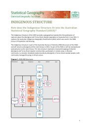
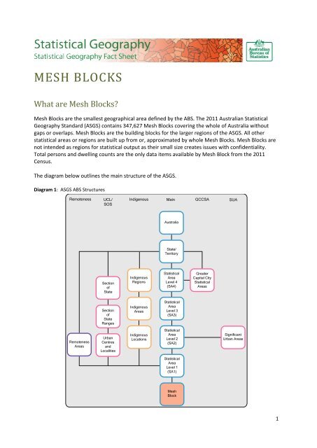
The diagram below outlines the main structure <strong>of</strong> the ASGS.<br />
Diagram 1: ASGS ABS Structures<br />
Remoteness<br />
UCL/<br />
SOS<br />
Indigenous<br />
Main<br />
GCCSA<br />
SUA<br />
Australia<br />
State/<br />
Territory<br />
Section<br />
<strong>of</strong><br />
State<br />
Indigenous<br />
Regions<br />
Statistical<br />
Area<br />
Level 4<br />
(SA4)<br />
Greater<br />
Capital City<br />
Statistical<br />
Areas<br />
Section<br />
<strong>of</strong><br />
State<br />
Ranges<br />
Indigenous<br />
Areas<br />
Statistical<br />
Area<br />
Level 3<br />
(SA3)<br />
Remoteness<br />
Areas<br />
Urban<br />
Centres<br />
and<br />
Localities<br />
Indigenous<br />
Locations<br />
Statistical<br />
Area<br />
Level 2<br />
(SA2)<br />
Significant<br />
Urban Areas<br />
Statistical<br />
Area<br />
Level 1<br />
(SA1)<br />
Mesh<br />
Block<br />
1
Diagram 2: ASGS Non-ABS Structures<br />
ABS Structures<br />
Non - ABS Structures<br />
Statistical<br />
Area<br />
Level 2<br />
(SA2)<br />
Tourism<br />
Regions<br />
(TR)<br />
Postal<br />
Areas<br />
(POA)<br />
State<br />
Suburbs<br />
(SSC)<br />
Commonwealth<br />
Electoral<br />
Divisions<br />
(CED)<br />
State<br />
Electoral<br />
Divisions<br />
(SED)<br />
<strong>Australian</strong><br />
Drainage<br />
Divisions<br />
(ADD)<br />
Natural<br />
Resource<br />
Management<br />
Regions<br />
(NRMR)<br />
Statistical<br />
Area<br />
Level 1<br />
(SA1)<br />
Mesh<br />
Blocks<br />
Local<br />
Government<br />
Areas<br />
(LGA)<br />
What criteria were used to define Mesh Blocks<br />
The Mesh Blocks were designed using a standard set <strong>of</strong> criteria. In priority order these can be<br />
summarised as:<br />
<br />
<br />
<br />
<br />
<br />
<br />
<br />
<br />
alignment to Statistical Local Area (SLA) and consequently Local Government Area (LGA)<br />
boundaries<br />
where possible to have a dwelling count <strong>of</strong> between 30 and 60 or contain no dwellings at all<br />
be <strong>of</strong> either urban or rural character<br />
where practical, not to cross cadastral boundaries<br />
to align to gazetted suburb and locality boundaries<br />
to reflect topographic features such as rivers, road, rail, major mountain ranges and escarpments<br />
to be <strong>of</strong> a compact size and shape<br />
to broadly reflect land use – the land use categories to which a mesh block can be assigned include<br />
o water<br />
o parkland<br />
o residential<br />
o industrial<br />
o commercial<br />
o education<br />
o hospital/medical<br />
o agricultural<br />
o transport<br />
o other.<br />
2
What data is available at the Mesh Block level<br />
Datasets containing counts <strong>of</strong> the total usual resident population and total dwellings from the 2011<br />
Census <strong>of</strong> Population and Housing for Mesh Blocks are available through the online publication<br />
Census <strong>of</strong> Population and Housing: Mesh Block Counts, 2011 (cat. no. 2074.0).<br />
The release <strong>of</strong> data is limited to avoid compromising the confidentiality <strong>of</strong> respondents in small<br />
geographical areas.<br />
Where can I get the Mesh Block boundaries<br />
The Mesh Block boundaries are available in MapInfo Interchange and ESRI Shapefile formats and can<br />
be downloaded from the ‘ABS Geography Publications’ chapter <strong>of</strong> the ABS Statistical Geography<br />
website: http://www.abs.gov.au/geography<br />
Alternatively, Mesh Block digital boundaries are available through the ‘Downloads’ tab <strong>of</strong> the ASGS<br />
Main Structures online publication: <strong>Australian</strong> Statistical Geography Standard (ASGS): Volume 1 - Main<br />
Structure and Greater Capital City Statistical Areas, July 2011 (cat. no. 1270.0.55.001).<br />
Where can I get further information<br />
A detailed discussion <strong>of</strong> Mesh Blocks and the criteria used in their design can be found in the online<br />
publication: <strong>Australian</strong> Statistical Geography Standard (ASGS): Volume 1 - Main Structure and Greater<br />
Capital City Statistical Areas, July 2011 (cat. no. 1270.0.55.001).<br />
More information on the ASGS and ABS Statistical Geography can be found by visiting the ABS<br />
website: http://www.abs.gov.au/geography<br />
Any questions or comments can be emailed to geography@abs.gov.au<br />
3