the florida state university college of arts and ... - Fuelberg Lab
the florida state university college of arts and ... - Fuelberg Lab
the florida state university college of arts and ... - Fuelberg Lab

Create successful ePaper yourself
Turn your PDF publications into a flip-book with our unique Google optimized e-Paper software.
THE FLORIDA STATE UNIVERSITY<br />
COLLEGE OF ARTS AND SCIENCES<br />
EFFECTS OF MULTI-SENSOR RADAR AND RAIN GAUGE DATA ON<br />
HYDROLOGIC MODELING IN RELATIVELY FLAT TERRAIN<br />
By STEVEN MICHAEL MARTINAITIS<br />
A <strong>the</strong>sis submitted to <strong>the</strong><br />
Department <strong>of</strong> Meteorology<br />
in partial fulfillment <strong>of</strong> <strong>the</strong><br />
requirements for <strong>the</strong> degree <strong>of</strong><br />
Master <strong>of</strong> Science<br />
Degree Awarded:<br />
Fall Semester, 2008
The members <strong>of</strong> <strong>the</strong> Committee approve <strong>the</strong> <strong>the</strong>sis <strong>of</strong> Steven M. Martinaitis defended on<br />
November 6, 2008.<br />
__________________________<br />
Henry E. <strong>Fuelberg</strong><br />
Pr<strong>of</strong>essor Directing Thesis<br />
__________________________<br />
Phillip Cunningham<br />
Committee Member<br />
__________________________<br />
Guosheng Liu<br />
Committee Member<br />
__________________________<br />
Ch<strong>and</strong>ra S. Pathak<br />
Committee Member<br />
The Office <strong>of</strong> Graduate Studies has verified <strong>and</strong> approved <strong>the</strong> above named committee<br />
members.<br />
ii
ACKNOWLEDGEMENTS<br />
I would like to first thank my major pr<strong>of</strong>essor, Dr. Henry <strong>Fuelberg</strong>, for his<br />
unwavering support <strong>and</strong> guidance in helping me to develop as a meteorologist, a<br />
pr<strong>of</strong>essional, <strong>and</strong> a person. I would have never had <strong>the</strong> experiences or opportunities that<br />
have been presented to me without <strong>the</strong> dedication that Dr. <strong>Fuelberg</strong> has for his students. I<br />
also would like to thank Drs. Philip Cunningham <strong>and</strong> Guosheng Liu for serving on my<br />
committee <strong>and</strong> for sharing <strong>the</strong>ir knowledge with me during multiple classes <strong>and</strong><br />
discussions. Dr. Ch<strong>and</strong>ra Pathak <strong>of</strong> <strong>the</strong> South Florida Water Management District<br />
(SFWMD) also deserves acknowledgement <strong>and</strong> my gratitude for not only serving as an<br />
outside committee member, but for being <strong>the</strong> catalyst behind this research. This project<br />
would not have been possible without <strong>the</strong> devotion <strong>and</strong> insight Dr. Pathak has for<br />
improving water management throughout <strong>the</strong> <strong>state</strong> <strong>of</strong> Florida.<br />
I would like to acknowledge Kent Feng at <strong>the</strong> SFWMD <strong>and</strong> Preston Manning at<br />
<strong>the</strong> Danish Hydraulic Institute (DHI) for <strong>the</strong>ir assistance with <strong>the</strong> MIKE SHE model, in<br />
addition to Dr. Harry Cooper for his guidance <strong>and</strong> knowledge with <strong>the</strong> model. I also<br />
want to extend my appreciation to <strong>the</strong> following personnel from NOAA/NWS for <strong>the</strong>ir<br />
assistance <strong>and</strong> insight with <strong>the</strong> FSU MPE database: Judy Bradberry (Sou<strong>the</strong>ast River<br />
Forecast Center), Jay Briedenbach (WFO-Boise), David Kitzmiller (Office <strong>of</strong> Hydrologic<br />
Development), Joel Lanier (WFO-Tallahassee), <strong>and</strong> D.J. Seo (Office <strong>of</strong> Hydrologic<br />
Development). The FSU MPE database was funded by <strong>the</strong> Florida Department <strong>of</strong><br />
Environmental Protection (FDEP). Therefore, many thanks are owed to Dr. T. S. Wu,<br />
Douglas Gilbert, <strong>and</strong> Jan M<strong>and</strong>rup-Poulsen from FDEP for <strong>the</strong>ir assistance with our<br />
product.<br />
I will always appreciate <strong>the</strong> support <strong>and</strong> countless laughs provided by every<br />
member <strong>of</strong> <strong>the</strong> <strong>Fuelberg</strong> <strong>Lab</strong>. I especially want to acknowledge Denny VanCleve <strong>and</strong><br />
John Sullivan for <strong>the</strong>ir knowledge <strong>and</strong> help with this project. I also want to acknowledge<br />
Steve Guimond, Pat & Jessica Taylor, <strong>and</strong> Andy Latto for <strong>the</strong>ir assistance with my<br />
iii
housing needs during my final semester. I would like to thank all my friends at Florida<br />
State University for making my <strong>college</strong> career memorable. Above all, I thank my family<br />
for supporting me <strong>and</strong> allowing me to pursue my dream. I would not be here without<br />
<strong>the</strong>m, <strong>and</strong> I am forever grateful for <strong>the</strong>m.<br />
This research was sponsored by <strong>the</strong> South Florida Water Management District<br />
<strong>and</strong> by <strong>the</strong> U.S. Geological Survey through a grant to <strong>the</strong> University <strong>of</strong> Florida (Grant<br />
No. 06HQGR0079). Additional support was provided by a Section 106 Water Pollution<br />
Control Program grant from <strong>the</strong> U.S. Environmental Protection Agency through a<br />
contract with <strong>the</strong> Bureau <strong>of</strong> Watershed Management <strong>of</strong> <strong>the</strong> Florida Department <strong>of</strong><br />
Environmental Protection.<br />
iv
TABLE OF CONTENTS<br />
List <strong>of</strong> Tables ..................................................................................................................... vi<br />
List <strong>of</strong> Figures ................................................................................................................... vii<br />
List <strong>of</strong> Abbreviations <strong>and</strong> Acronyms ................................................................................ xii<br />
Abstract ............................................................................................................................ xiv<br />
1. INTRODUCTION ..........................................................................................................1<br />
2. DATA AND METHODOLOGY ....................................................................................8<br />
2.1 Area <strong>of</strong> Interest (AOI) ..............................................................................................8<br />
2.2 MIKE SHE Model .................................................................................................12<br />
2.2.1 Model Physics ................................................................................................13<br />
2.2.2 Input Data.......................................................................................................21<br />
2.3 Rain Gauge Data ....................................................................................................27<br />
2.4 Gauge-Adjusted Radar Data ..................................................................................32<br />
2.5 Methodology ..........................................................................................................36<br />
3. RESULTS .....................................................................................................................38<br />
3.1 Three-Month Periods .............................................................................................41<br />
3.1.1 COCO1_T <strong>and</strong> FU1_T Gauge Stations .........................................................44<br />
3.1.2 CORK <strong>and</strong> GOLD_951 Gauge Stations ........................................................55<br />
3.1.3 Summary <strong>of</strong> Period Statistics .........................................................................65<br />
3.2 Case Studies ...........................................................................................................69<br />
3.2.1 Summer Convective Activity .........................................................................69<br />
3.2.2 Hurricane Wilma ............................................................................................78<br />
4. SUMMARY AND CONCLUSIONS ...........................................................................87<br />
REFERENCES ..................................................................................................................92<br />
BIOGRAPHICAL SKETCH .............................................................................................99<br />
v
LIST OF TABLES<br />
Table 1. L<strong>and</strong> type designation for each l<strong>and</strong> use code. ...................................................23<br />
Table 2. UZ soil type designation for each l<strong>and</strong> use code, with <strong>the</strong> number <strong>of</strong> sub-types<br />
for each designation <strong>and</strong> <strong>the</strong> maximum depth <strong>of</strong> each UZ soil type. .................................26<br />
Table 3. Three month periods being considered along with average daily MAP for each<br />
period based on <strong>the</strong> SFWMD gauges <strong>and</strong> <strong>the</strong> FSU MPE dataset. .....................................41<br />
Table 4. Periods removed from <strong>the</strong> three-month study periods due to missing observed<br />
(Obs) values or anomalous spikes in modeled stages. The M24 <strong>and</strong> G01 spikes at<br />
COCO1_T <strong>and</strong> GOLD_951 for MAM 04 do not occur simultaneously, but overlap during<br />
<strong>the</strong> removed time period. ...................................................................................................44<br />
Table 5. Evaluation <strong>of</strong> <strong>the</strong> two temporal resolutions for each precipitation dataset (M01<br />
vs. M24 <strong>and</strong> G01 vs. G24). The number listed under each precipitation type is <strong>the</strong><br />
number <strong>of</strong> times that it outperformed or tied its counterpart for each statistical parameter.<br />
............................................................................................................................................67<br />
Table 6. Evaluation <strong>of</strong> <strong>the</strong> two precipitation datasets for each temporal resolution (M01<br />
vs. G01 <strong>and</strong> M24 vs. G24). The number listed under each precipitation type is <strong>the</strong><br />
number <strong>of</strong> times that it outperformed or tied its counterpart for each statistical measure.<br />
............................................................................................................................................67<br />
Table 7. Evaluation <strong>of</strong> <strong>the</strong> two precipitation types with <strong>the</strong> highest <strong>and</strong> lowest<br />
spatial/temporal resolution combination (M01 vs. G24). The number listed under each<br />
precipitation type is <strong>the</strong> number <strong>of</strong> times that it outperformed or tied its counterpart for<br />
each statistical measure. .....................................................................................................68<br />
Table 8. Stage statistics for every spatial/temporal precipitation combination at each<br />
stream gauge during <strong>the</strong> July 18-31, 2005 case study. ......................................................74<br />
Table 9. Overall statistics for each spatial/temporal precipitation combination at each<br />
stage location during <strong>the</strong> October 18-31, 2005 case study. ...............................................83<br />
vi
LIST OF FIGURES<br />
Figure 1. Correlograms <strong>of</strong> rain gauge data from SFWMD a) hourly <strong>and</strong> b) daily<br />
precipitation totals from 1996-2001 (after Quina 2003). The solid line represents <strong>the</strong><br />
least squares best fit line. .....................................................................................................3<br />
Figure 2. Correlograms <strong>of</strong> hourly gauge values from <strong>the</strong> Oklahoma Mesonet (black<br />
points) <strong>and</strong> ARB micronet (gray points) from June to September 1997 (after Young et al.<br />
2000). The three curves are fitted exponential correlation models to <strong>the</strong> mesonet data<br />
(long dashed), micronet data (short dashed), <strong>and</strong> <strong>the</strong> combination <strong>of</strong> <strong>the</strong> two (solid). ........4<br />
Figure 3. The SFWMD (green) <strong>and</strong> location <strong>of</strong> <strong>the</strong> BCB AOI (red) near <strong>the</strong> Everglades<br />
NP <strong>and</strong> Big Cypress NPRES................................................................................................9<br />
Figure 4. Canals (blue lines) <strong>and</strong> water control structures (red points) within <strong>the</strong> BCB<br />
(after Manning <strong>and</strong> Butts, unpublished internal report, July 2008). ..................................10<br />
Figure 5. Topography (m) <strong>of</strong> <strong>the</strong> BCB AOI at 500 ft (152.4 m) resolution as displayed in<br />
MIKE SHE. The black lines represent canals <strong>and</strong> waterways within <strong>the</strong> AOI.................11<br />
Figure 6. Schematic representation <strong>of</strong> <strong>the</strong> MIKE SHE hydrologic model (after Refsgaard<br />
<strong>and</strong> Storm 1995). ................................................................................................................13<br />
Figure 7. Schematic representation <strong>of</strong> interception <strong>and</strong> evapotranspiration (after Abbott<br />
et al. 1986a). .......................................................................................................................15<br />
Figure 8. Cross-section at <strong>the</strong> D2-7_T gauge site on <strong>the</strong> I-75 canal as depicted in MIKE<br />
SHE. The red line indicates <strong>the</strong> minimum depth <strong>of</strong> <strong>the</strong> canal at this point, <strong>the</strong> pink line is<br />
<strong>the</strong> x,z cross-section at <strong>the</strong> gauge site, <strong>the</strong> outer cyan lines represent <strong>the</strong> boundary <strong>of</strong> <strong>the</strong><br />
cross-section, <strong>and</strong> <strong>the</strong> inner cyan lines represent locations where <strong>the</strong> resistance coefficient<br />
changes based on <strong>the</strong> Manning M value. ...........................................................................20<br />
Figure 9. L<strong>and</strong> use codes in <strong>the</strong> AOI as defined by <strong>the</strong> SFWMD in 2004. Definitions <strong>of</strong><br />
each l<strong>and</strong> use type are found in Table 1. The black lines represent canals <strong>and</strong> waterways<br />
within <strong>the</strong> AOI. ..................................................................................................................22<br />
Figure 10. UZ soil type codes in <strong>the</strong> AOI as defined by <strong>the</strong> SFWMD. The black lines<br />
represent canals <strong>and</strong> waterways within <strong>the</strong> AOI. ...............................................................25<br />
Figure 11. Thiessen polygons <strong>of</strong> <strong>the</strong> SFWMD gauges used as precipitation input. The<br />
blue dots represent <strong>the</strong> location <strong>of</strong> each gauge. .................................................................28<br />
vii
Figure 12. Hourly gauges provided by <strong>the</strong> NCDC <strong>and</strong> five Florida WMDs during <strong>the</strong><br />
2004 calendar year for <strong>the</strong> FSU MPE database. ................................................................29<br />
Figure 13. Percentage <strong>of</strong> missing hours during <strong>the</strong> entire study period (light gray) <strong>and</strong><br />
while <strong>the</strong> gauge was operational (dark gray). ....................................................................31<br />
Figure 14. Percentage <strong>of</strong> missing hours that were filled with zero precipitation (dark<br />
gray) <strong>and</strong> non-zero precipitation (light gray) during <strong>the</strong> entire study period. The dashed<br />
line represents <strong>the</strong> average percentage <strong>of</strong> gauges that were filled with zero precipitation.<br />
............................................................................................................................................31<br />
Figure 15. Radar coverage over <strong>the</strong> SFWMD <strong>and</strong> BCB AOI. The range <strong>of</strong> each radar is<br />
230 km. ..............................................................................................................................34<br />
Figure 16. HRAP grid cells that are located within 2 km <strong>of</strong> <strong>the</strong> BCB AOI. Red asterisks<br />
denote gauge stations used for stage height analysis. ........................................................35<br />
Figure 17. Representation <strong>of</strong> observed hourly (blue line) <strong>and</strong> interpolated daily (red line)<br />
FSU MPE precipitation input to <strong>the</strong> MIKE SHE model at <strong>the</strong> HRAP grid cell 71_32<br />
(upper left) on August 1, 2004. The gray bars represent <strong>the</strong> precipitation estimated by <strong>the</strong><br />
FSU MPE algorithm at individual hours. ..........................................................................39<br />
Figure 18. Schematic <strong>of</strong> a waterway with a negative stage height. ..................................40<br />
Figure 19. Hydrographs <strong>of</strong> daily stages at COCO1_T during JJA 2005 (a) <strong>and</strong> MAM<br />
2004 (b). The red circles indicate areas <strong>of</strong> anomalous MIKE SHE model output. Note<br />
that <strong>the</strong> various lines overlap in some portions <strong>of</strong> <strong>the</strong> graph. ............................................43<br />
Figure 20. MIKE SHE modeled mean stages at COCO1_T (a) <strong>and</strong> FU1_T (b) with mean<br />
observed stage (dashed line) for all three-month periods. Note that <strong>the</strong> various lines<br />
overlap in some portions <strong>of</strong> <strong>the</strong> graph................................................................................46<br />
Figure 21. Daily mean difference between observed <strong>and</strong> MIKE SHE modeled stages at<br />
COCO1_T (a) <strong>and</strong> FU1_T (b) for all three-month periods. Note that <strong>the</strong> various lines<br />
overlap in some portions <strong>of</strong> <strong>the</strong> graph................................................................................47<br />
Figure 22. St<strong>and</strong>ard deviation <strong>of</strong> daily differences between observed <strong>and</strong> MIKE SHE<br />
modeled stages at COCO1_T (a) <strong>and</strong> FU1_T (b) for all three-month periods. Note that<br />
<strong>the</strong> various lines overlap in some portions <strong>of</strong> <strong>the</strong> graph. ...................................................48<br />
Figure 23. Hydrographs <strong>of</strong> daily stages during JJA 2004 at COCO1_T (a) <strong>and</strong> FU1_T<br />
(b). The gap in <strong>the</strong> COCO1_T hydrograph (a) corresponds to a section <strong>of</strong> removed data<br />
due to an anomalous spike in <strong>the</strong> G01 output (Table 4). Note that <strong>the</strong> various lines<br />
overlap in some portions <strong>of</strong> <strong>the</strong> graph................................................................................49<br />
viii
Figure 24. Sub-section <strong>of</strong> <strong>the</strong> DJF 2004 hydrograph <strong>of</strong> daily stages at COCO1_T. Note<br />
that all four modeled stages overlap for <strong>the</strong> entire time period <strong>of</strong> <strong>the</strong> graph. ....................50<br />
Figure 25. Coefficient <strong>of</strong> determination (R 2 ) between observed <strong>and</strong> MIKE SHE modeled<br />
stages at COCO1_T (a) <strong>and</strong> FU1_T (b) for all three-month periods. Note that <strong>the</strong> various<br />
lines overlap in some portions <strong>of</strong> <strong>the</strong> graph. ......................................................................52<br />
Figure 26. Scatter-plots <strong>of</strong> observed vs. model stages at COCO1_T (a) <strong>and</strong> FU1_T (b)<br />
during JJA 2005. The trendlines <strong>and</strong> R 2 values are color-coded to match <strong>the</strong> points for<br />
each comparison. The dashed line represents <strong>the</strong> one-to-one line. ...................................53<br />
Figure 27. Thiel’s inequality coefficient (U) between observed <strong>and</strong> MIKE SHE modeled<br />
stages at COCO1_T (a) <strong>and</strong> FU1_T (b) for all three-month periods. Note that <strong>the</strong> various<br />
lines overlap in some portions <strong>of</strong> <strong>the</strong> graph. ......................................................................54<br />
Figure 28. MIKE SHE modeled mean stages at CORK (a) <strong>and</strong> GOLD_951 (b) with<br />
mean observed stage (dashed line) for all three-month periods. Note that <strong>the</strong> various<br />
lines overlap in some portions <strong>of</strong> <strong>the</strong> graph. ......................................................................56<br />
Figure 29. Daily mean difference between observed <strong>and</strong> MIKE SHE modeled stages at<br />
CORK (a) <strong>and</strong> GOLD_951 (b) for all three-month periods. Note that <strong>the</strong> various lines<br />
overlap in some portions <strong>of</strong> <strong>the</strong> graph................................................................................57<br />
Figure 30. Hydrographs <strong>of</strong> daily stages at GOLD_951 during SON 2003 (a) <strong>and</strong> DJF<br />
2004 (b). Note that <strong>the</strong> various lines overlap in some portions <strong>of</strong> <strong>the</strong> graph. ...................58<br />
Figure 31. Scatter-plot <strong>of</strong> initialized stages vs. <strong>the</strong> three-month daily mean difference for<br />
M24 <strong>and</strong> G24 precipitation input at CORK <strong>and</strong> GOLD_951. The trendlines <strong>and</strong> R 2<br />
values are color-coded to match <strong>the</strong> points for each comparison. .....................................59<br />
Figure 32. St<strong>and</strong>ard deviation <strong>of</strong> daily differences between observed <strong>and</strong> MIKE SHE<br />
modeled stages at CORK (a) <strong>and</strong> GOLD_951 (b) for all three-month periods. Note that<br />
<strong>the</strong> various lines overlap in some portions <strong>of</strong> <strong>the</strong> graph. ...................................................61<br />
Figure 33. Coefficient <strong>of</strong> determination (R 2 ) between observed <strong>and</strong> MIKE SHE modeled<br />
stages at CORK (a) <strong>and</strong> GOLD_951 (b) for all three-month periods. Note that <strong>the</strong><br />
various lines overlap in some portions <strong>of</strong> <strong>the</strong> graph. .........................................................62<br />
Figure 34. Scatter-plots <strong>of</strong> observed vs. model stages at CORK (a) <strong>and</strong> GOLD_951 (b)<br />
during JJA 2005. The trendlines <strong>and</strong> R 2 values are color-coded to match <strong>the</strong> points for<br />
each comparison. The dashed line represents <strong>the</strong> one-to-one line. ...................................63<br />
Figure 35. Thiel’s inequality coefficient (U) between observed <strong>and</strong> MIKE SHE modeled<br />
stages at CORK (a) <strong>and</strong> GOLD_951 (b) for all three-month periods. Note that <strong>the</strong><br />
various lines overlap in some portions <strong>of</strong> <strong>the</strong> graph. .........................................................64<br />
ix
Figure 36. Scatter-plot <strong>of</strong> daily MAP from FSU MPE vs. MAP from SFWMD gauges<br />
during <strong>the</strong> entire study period. The trendline is represented by <strong>the</strong> solid black line, while<br />
<strong>the</strong> dashed line represents <strong>the</strong> one-to-one line. Two points lie outside <strong>the</strong> domain <strong>of</strong> this<br />
graph. .................................................................................................................................65<br />
Figure 37. Accumulated SFWMD rain gauge-derived precipitation for each Thiessen<br />
polygon between July 18-31, 2004. The asterisks denote <strong>the</strong> locations <strong>of</strong> stream gauges<br />
used for stage analysis. ......................................................................................................70<br />
Figure 38. Accumulated FSU MPE estimated precipitation for each HRAP grid cell<br />
between July 18-31, 2004. The asterisks denote <strong>the</strong> locations <strong>of</strong> stream gauges used for<br />
stage analysis. ....................................................................................................................71<br />
Figure 39. Daily MAP from FSU MPE, SFWMD rain gauges, <strong>and</strong> <strong>the</strong> difference (FSU<br />
MPE minus SFWMD rain gauges) from July 19 to August 1, 2004. Note that <strong>the</strong> date is<br />
based on <strong>the</strong> ending time stamp <strong>of</strong> <strong>the</strong> 24 h period (i.e., precipitation on July 19 is from<br />
0000 EST July 18 to 0000 EST July 19)............................................................................72<br />
Figure 40. Hydrographs <strong>of</strong> daily stages at COCO1_T between July 18-31, 2004. Note<br />
that <strong>the</strong> various lines overlap in some portions <strong>of</strong> <strong>the</strong> graph. ............................................73<br />
Figure 41. Hydrographs <strong>of</strong> daily stages at CORK during <strong>the</strong> July 18-31, 2004 case study.<br />
Note that <strong>the</strong> various lines overlap in some portions <strong>of</strong> <strong>the</strong> graph.....................................75<br />
Figure 42. Hydrographs <strong>of</strong> daily stages at FU1_T during <strong>the</strong> July 18-31, 2004 case study.<br />
Note that <strong>the</strong> various lines overlap in some portions <strong>of</strong> <strong>the</strong> graph.....................................76<br />
Figure 43. Hydrographs <strong>of</strong> daily stages at GOLD_951 during <strong>the</strong> July 18-31, 2004 case<br />
study. Note that <strong>the</strong> various lines overlap in some portions <strong>of</strong> <strong>the</strong> graph. ........................77<br />
Figure 44. Accumulated SFWMD rain gauge precipitation for each Thiessen polygon<br />
between October 18-31, 2005. The top number in each polygon represents <strong>the</strong> number <strong>of</strong><br />
gauge hours deemed missing or erroneous during <strong>the</strong> entire two-week period. The<br />
bottom fraction represents <strong>the</strong> number <strong>of</strong> gauge hours deemed missing or erroneous<br />
during <strong>the</strong> 15 h period from 2000 EST October 23 to 1000 EST October 24. The<br />
asterisks denote <strong>the</strong> locations <strong>of</strong> stream gauges used for stage analysis............................79<br />
Figure 45. Accumulated FSU MPE estimated precipitation for each HRAP grid cell from<br />
October 18-31, 2005. The asterisks denote <strong>the</strong> locations <strong>of</strong> stream gauges used for stage<br />
analysis. ..............................................................................................................................80<br />
Figure 46. Daily MAP from FSU MPE, SFWMD rain gauges, <strong>and</strong> <strong>the</strong> difference (FSU<br />
MPE minus SFWMD rain gauges) from October 19 to November 1, 2005. Note that <strong>the</strong><br />
date is based on <strong>the</strong> ending time stamp <strong>of</strong> <strong>the</strong> 24 h period (i.e., precipitation on October<br />
19 is from 0000 EST October 18 to 0000 EST October 19). .............................................81<br />
x
Figure 47. Hydrographs <strong>of</strong> daily stages at COCO1_T during <strong>the</strong> October 18-31, 2005<br />
case study. Note that <strong>the</strong> various lines overlap in some portions <strong>of</strong> <strong>the</strong> graph. ................82<br />
Figure 48. Hydrographs <strong>of</strong> daily stages at FU1_T during <strong>the</strong> October 18-31, 2005 case<br />
study. Note that <strong>the</strong> various lines overlap in some portions <strong>of</strong> <strong>the</strong> graph. ........................84<br />
Figure 49. Hydrographs <strong>of</strong> daily stages at CORK during <strong>the</strong> October 18-31, 2005 case<br />
study. Note that <strong>the</strong> various lines overlap in some portions <strong>of</strong> <strong>the</strong> graph. ........................85<br />
Figure 50. Hydrographs <strong>of</strong> daily stages at GOLD_951 during <strong>the</strong> October 18-31, 2005<br />
case study. Note that <strong>the</strong> various lines overlap in some portions <strong>of</strong> <strong>the</strong> graph. ................86<br />
xi
ABBREVIATIONS AND ACRONYMS<br />
AOI<br />
ARB<br />
BCB<br />
BMOSAIC<br />
CWA<br />
DHI<br />
DJF<br />
FSU<br />
G01<br />
G24<br />
GMOSAIC<br />
HDPA<br />
HRAP<br />
JJA<br />
KAMX<br />
KBYX<br />
KMLB<br />
KTBW<br />
M01<br />
M24<br />
MAM<br />
MAP<br />
MMOSAIC<br />
MPE<br />
NAD<br />
NAVD<br />
NCDC<br />
NP<br />
NPRES<br />
NWFWMD<br />
NWS<br />
OE<br />
PCG<br />
PET<br />
PMOSAIC<br />
PPS<br />
PSRP<br />
QC<br />
R<br />
area <strong>of</strong> interest<br />
Arkansas-Red River Basin<br />
Big Cypress Basin<br />
bias-adjusted radar mosaic<br />
County Warning Area<br />
Danish Hydraulic Institute<br />
December, January, February three-month period<br />
Florida State University<br />
hourly SFWMD rain gauge precipitation<br />
daily SFWMD rain gauge precipitation<br />
gauge-only mosaic<br />
Hourly Digital Precipitation Array<br />
Hydrologic Rainfall Analysis Project<br />
June, July, August three-month period<br />
Miami WSR-88D<br />
Key West WSR-88D<br />
Melbourne WSR-88D<br />
Tampa Bay WSR-88D<br />
hourly FSU MPE precipitation<br />
daily FSU MPE precipitation<br />
March, April, May three-month period<br />
mean areal precipitation<br />
multi-sensor mosaic<br />
Multi-sensor Precipitation Estimator<br />
North American Datum<br />
North American Vertical Datum<br />
National Climatic Data Center<br />
national park<br />
national preserve<br />
Northwest Florida Water Management District<br />
National Wea<strong>the</strong>r Service<br />
Optimal Estimation<br />
pre-conditioned conjugate gradient<br />
potential evapotranspiration<br />
Thiessen polygon derived mosaic<br />
Precipitation Processing System<br />
Picayune Str<strong>and</strong> Restoration Project<br />
quality control<br />
correlation<br />
xii
R 2<br />
RFC<br />
RMOSAIC<br />
RTHMS<br />
SERFC<br />
SFWMD<br />
SHE<br />
SJRWMD<br />
SON<br />
SRWMD<br />
SWFWMD<br />
SZ<br />
U<br />
USACE<br />
USGS<br />
UZ<br />
WAM<br />
WFO<br />
WMD<br />
WSR-88D<br />
coefficient <strong>of</strong> determination<br />
River Forecast Center<br />
radar-only mosaic<br />
Real Time Hydrologic Modeling System<br />
Sou<strong>the</strong>ast River Forecast Center<br />
South Florida Water Management District<br />
Système Hydrologique Européen<br />
St. Johns River Water Management District<br />
September, October, November three-month period<br />
Suwannee River Water Management District<br />
Southwest Florida Water Management District<br />
saturated zone<br />
Theil’s inequality coefficient<br />
United States Army Corps <strong>of</strong> Engineers<br />
United States Geological Survey<br />
unsaturated zone<br />
Watershed Assessment Model<br />
Wea<strong>the</strong>r Forecast Office<br />
water management district<br />
Wea<strong>the</strong>r Surveillance Radar-1988 Doppler<br />
xiii
ABSTRACT<br />
This study evaluates <strong>the</strong> impacts <strong>of</strong> two different precipitation types on stage<br />
heights from a fully integrated <strong>and</strong> distributed, physically based hydrologic model –<br />
MIKE SHE. Simulations using a network <strong>of</strong> South Florida Water Management District<br />
(SFWMD) rain gauge measurements in <strong>the</strong> form <strong>of</strong> Thiessen polygons are compared with<br />
those using a ~ 4 × 4 km gridded historical precipitation database prepared at Florida<br />
State University (FSU). The FSU procedure employs a version <strong>of</strong> <strong>the</strong> National Wea<strong>the</strong>r<br />
Service (NWS) Multi-sensor Precipitation Estimator (MPE) algorithm. Each<br />
precipitation input is at both hourly <strong>and</strong> daily intervals. Simulated stages from MIKE<br />
SHE are evaluated over <strong>the</strong> relatively flat Big Cypress Basin (BCB) which has a<br />
maximum elevation range <strong>of</strong> ~ 12.5 m over a 1661 km 2 area. Daily averaged stage<br />
heights are analyzed at four stream gauge sites along canals within <strong>the</strong> BCB using<br />
seasonally based three-month model runs between 2003 to 2005 plus two separate case<br />
studies containing significant rainfall accumulations.<br />
Results show a high correlation between precipitation values <strong>of</strong> <strong>the</strong> FSU MPE<br />
database <strong>and</strong> <strong>the</strong> SFWMD rain gauges because <strong>the</strong> rain gauge data are incorporated into<br />
<strong>the</strong> MPE algorithm. Therefore, stage hydrographs <strong>and</strong> statistical properties <strong>of</strong> <strong>the</strong> stages<br />
generally are very similar between <strong>the</strong> two precipitation datasets at both temporal<br />
resolutions. Slightly greater differences are found between observed stages <strong>and</strong> those<br />
from <strong>the</strong> four versions <strong>of</strong> modeled output. The high resolution FSU MPE precipitation<br />
estimates generally provide improved stages compared to <strong>the</strong> SFWMD rain gauges. The<br />
use <strong>of</strong> hourly temporal resolution input impacts <strong>the</strong> timing <strong>and</strong> magnitude <strong>of</strong> <strong>the</strong> resulting<br />
stages. The modeled stages based on hourly precipitation values generally provide a<br />
faster hydrologic response <strong>and</strong> better simulate <strong>the</strong> observed stages than do daily values<br />
during extreme rainfall events (e.g., Hurricane Wilma). We believe that improved multisensor<br />
products <strong>and</strong> quality control procedures can be beneficial to enhancing water<br />
management decisions <strong>and</strong> flood forecasting within <strong>the</strong> SFWMD.<br />
xiv
CHAPTER ONE<br />
INTRODUCTION<br />
With an ever increasing human population, water management is essential to<br />
families, businesses, <strong>and</strong> <strong>the</strong> environment. Precipitation is <strong>the</strong> driving force in water<br />
movement <strong>and</strong> water resources. An overabundance <strong>of</strong> precipitation can threaten life <strong>and</strong><br />
property, while drought stricken areas endure water shortages <strong>and</strong> <strong>the</strong> loss <strong>of</strong> crops <strong>and</strong><br />
o<strong>the</strong>r vegetation. Both situations lead to economic hardship at all levels <strong>of</strong> society.<br />
Therefore, government agencies <strong>and</strong> private industries require accurate rainfall<br />
measurements for water resource management, flood forecasting, structural engineering,<br />
<strong>and</strong> regulatory decisions.<br />
Rain gauges traditionally have provided <strong>the</strong> needed precipitation input to<br />
hydrologic models. Although gauges are deemed to be <strong>the</strong> “ground truth” for<br />
precipitation, <strong>the</strong>y do have limitations. Errors in gauge measurements arise from<br />
obstructions, clogging, poor gauge placement, evaporation, <strong>and</strong> mechanical malfunctions<br />
(Wilson <strong>and</strong> Br<strong>and</strong>es 1979; Essery <strong>and</strong> Wilcock 1990; Servuk 1991; Legates <strong>and</strong><br />
DeLiberty 1993; Habib et al. 1999; Marzen <strong>and</strong> <strong>Fuelberg</strong> 2005; Yoo et al. 2008).<br />
Fur<strong>the</strong>rmore, unshielded gauges greatly underestimate precipitation during strong wind<br />
events (Yang et al. 1998; Habib et al.1999). During tropical cyclones, missing gauge<br />
data can result from structural damage to <strong>the</strong> gauge, loss <strong>of</strong> automated transmissions due<br />
to electrical failure, or observers who have fled to safety.<br />
Most rain gauges have an 8 in. diameter opening <strong>and</strong> typically are spaced many<br />
kilometers apart. Thus, <strong>the</strong>ir point source data may not adequately represent spatial<br />
rainfall variations over large areas, particularly in Florida where isolated, convective<br />
thunderstorms are common (Wilson <strong>and</strong> Br<strong>and</strong>es 1979; Smith et al. 1996; Baeck <strong>and</strong><br />
Smith 1998). Quina (2003) correlated hourly <strong>and</strong> daily gauge values between 1996 <strong>and</strong><br />
2001 in <strong>the</strong> South Florida Water Management District (SFWMD) as a function <strong>of</strong> intergauge<br />
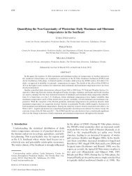
distance. Figure 1 shows <strong>the</strong> rapid decrease in correlation as <strong>the</strong> inter-gauge<br />
1
distance increases. Hourly rainfall values exhibit a correlation (R) <strong>of</strong> ~ 0.80 when <strong>the</strong><br />
gauges are approximately 2 km apart (Figure 1a), while daily totals produce <strong>the</strong> same<br />
correlation at a separation <strong>of</strong> 4 km (Figure 1b). Increasing <strong>the</strong> hourly inter-gauge<br />
distance to 10 km reduces R to ~ 0.45. These gauge separations are small compared to<br />
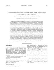
those from <strong>the</strong> Oklahoma Mesonet <strong>and</strong> <strong>the</strong> Arkansas-Red River Basin (ARB) micronet<br />
gauge network (Figure 2) where hourly gauge data at a separation <strong>of</strong> 30-40 km produce R<br />
~ 0.45 (Young et al. 2000). It is clear that only a very dense gauge network could capture<br />
<strong>the</strong> small scale variability generated by <strong>the</strong> large spatial rainfall gradients in Florida.<br />
The National Wea<strong>the</strong>r Service (NWS) Wea<strong>the</strong>r Surveillance Radar-1988 Doppler<br />
(WSR-88D) estimates rainfall at high spatial (1 km radial, 1-degree azimuth, 230 km<br />
radius) <strong>and</strong> temporal (5-10 min) resolution (Klazura <strong>and</strong> Imy 1993; Fulton et al. 1998).<br />
Reflectivity values, Z, from <strong>the</strong> WSR-88D can be translated into rain rates, R, through an<br />
empirical power-law function (Z-R relationship),<br />
b<br />
Z = AR , (1)<br />
where A <strong>and</strong> b are constants that depend on <strong>the</strong> drop size distribution in <strong>the</strong> precipitating<br />
cloud. Although studies have detailed how <strong>the</strong> Z-R relationship can vary from storm to<br />
storm (Wilson <strong>and</strong> Br<strong>and</strong>es 1979; Joss <strong>and</strong> Waldvogel 1990) <strong>and</strong> even during <strong>the</strong> life<br />
cycle <strong>of</strong> a storm (Austin 1987; Smith <strong>and</strong> Krajewski 1993; Fabry <strong>and</strong> Zawadzki 1995),<br />
only a few Z-R relationships are used operationally (VanCleve <strong>and</strong> <strong>Fuelberg</strong> 2007).<br />
Because radars remotely sense precipitation, <strong>the</strong>se data have <strong>the</strong>ir own inherent<br />
limitations. Use <strong>of</strong> <strong>the</strong> lowest beam elevation angle can produce blockage by trees,<br />
buildings, <strong>and</strong> o<strong>the</strong>r tall structures (Young et al. 1999; Borga et al. 2000). Conversely,<br />
<strong>the</strong> combination <strong>of</strong> beam elevation angle <strong>and</strong> <strong>the</strong> Earth’s curvature can lead to <strong>the</strong><br />
overshooting <strong>of</strong> low-top stratiform precipitation (Smith et al. 1996; Pereira Fo et al.<br />
1998). O<strong>the</strong>r limitations <strong>of</strong> radar-derived precipitation include anomalous propagation<br />
<strong>and</strong> bright b<strong>and</strong>ing (Smith 1986), hail contamination (Fulton 1999; Nelson et al. 2003),<br />
differences between reflectivity al<strong>of</strong>t <strong>and</strong> surface rainfall (Austin 1987; Borga et al. 1997;<br />
Jordan et al. 2000), ground clutter <strong>and</strong> non-meteorological echoes (Hudlow et al. 1983;<br />
Harrison et al. 2000), improper calibration (Smith et al. 1996; Ulbrich <strong>and</strong> Lee 1999;<br />
Young et al. 1999; Anagnostou et al 2001), <strong>and</strong> outages due to wea<strong>the</strong>r events (Sullivan<br />
2
Figure 1. Correlograms <strong>of</strong> rain gauge data from SFWMD a) hourly <strong>and</strong> b) daily<br />
precipitation totals from 1996-2001 (after Quina 2003). The solid line represents <strong>the</strong><br />
least squares best fit line.<br />
3
Figure 2. Correlograms <strong>of</strong> hourly gauge values from <strong>the</strong> Oklahoma Mesonet (black<br />
points) <strong>and</strong> ARB micronet (gray points) from June to September 1997 (after Young et al.<br />
2000). The three curves are fitted exponential correlation models to <strong>the</strong> mesonet data<br />
(long dashed), micronet data (short dashed), <strong>and</strong> <strong>the</strong> combination <strong>of</strong> <strong>the</strong> two (solid).<br />
2008). Finally, it is important to note that unlike gauges, radars sample volumes whose<br />
sizes increase with distance from <strong>the</strong> radar site.<br />
Given <strong>the</strong> attributes <strong>of</strong> radar <strong>and</strong> gauge data, an optimum combination <strong>of</strong> <strong>the</strong> two<br />
should maximize <strong>the</strong> strengths <strong>of</strong> each while minimizing <strong>the</strong>ir weaknesses. One such<br />
optimization program is <strong>the</strong> NWS Multi-sensor Precipitation Estimator (MPE)<br />
(Breidenbach et al. 1998; Breidenbach <strong>and</strong> Bradberry 2001). The MPE algorithm<br />
combines <strong>the</strong> high spatial resolution <strong>of</strong> radar estimated precipitation with <strong>the</strong> relatively<br />
accurate gauge measured rainfall. A version <strong>of</strong> <strong>the</strong> MPE scheme has been employed at<br />
Florida State University (FSU) to create a historical precipitation dataset over Florida<br />
(Quina 2003; Marzen <strong>and</strong> <strong>Fuelberg</strong> 2005). Previous studies at FSU have quantified <strong>the</strong><br />
differences between gauge-only rainfall <strong>and</strong> <strong>the</strong> multi-sensor FSU MPE dataset. Quina<br />
4
(2003) <strong>and</strong> Marzen <strong>and</strong> <strong>Fuelberg</strong> (2005) compared <strong>the</strong> two over varying temporal<br />
resolutions, differing precipitation types (stratiform <strong>and</strong> convective), <strong>and</strong> various seasons.<br />
VanCleve <strong>and</strong> <strong>Fuelberg</strong> (2007) performed basin-wide studies <strong>of</strong> differences in mean areal<br />
precipitation (MAP) between gauge-derived Thiessen polygons <strong>and</strong> <strong>the</strong> gridded FSU<br />
MPE product. The FSU MPE dataset also has been employed in hydrologic models,<br />
including MIKE SHE (Cooper et al. 2006) <strong>and</strong> <strong>the</strong> Watershed Assessment Model<br />
(WAM) (Sullivan et al. 2008).<br />
Technological advancements have allowed higher resolution <strong>and</strong> increasingly<br />
complex data to be input to hydrologic models, e.g., topography, l<strong>and</strong> use, soils, <strong>and</strong><br />
evapotranspiration. However, <strong>the</strong>re still is hesitation to use spatially distributed rainfall<br />
instead <strong>of</strong> point-based gauge data. Johnson et al. (1999) <strong>state</strong>d that radar-derived values<br />
give viable MAP values, but “a problem <strong>of</strong> inconsistency is identified; however, <strong>the</strong> level<br />
to which <strong>the</strong>se inconsistencies will affect hydrologic <strong>and</strong> climatologic models has yet to<br />
be determined.” Works by Numec (1985), Joss <strong>and</strong> Waldvogel (1990), Smith <strong>and</strong><br />
Krajewski (1991), Collier (1996), Winchell et al. (1998), Jordan et al. (2000), <strong>and</strong><br />
Jayakrishnan et al. (2004) also have emphasized that <strong>the</strong> limitations <strong>of</strong> radar data can<br />
produce erroneous streamflow <strong>and</strong> run<strong>of</strong>f estimates. Sullivan (2008) elaborated on this<br />
hesitation by noting that “<strong>the</strong>re appears to be confusion about <strong>the</strong> impacts <strong>of</strong> strictly<br />
radar-derived data versus multi-sensor schemes” <strong>and</strong> that “all radar-derived precipitation<br />
data are not <strong>of</strong> <strong>the</strong> same quality.”<br />
Numerous studies have utilized radar-derived precipitation in hydrologic<br />
modeling (Bell <strong>and</strong> Moore 1998; Vieux <strong>and</strong> Bedient 1998; Borga et al. 2000; Zhijia et al.<br />
2004; Cooper et al. 2006; among o<strong>the</strong>rs). Borga (2002) compared <strong>the</strong> accuracy <strong>of</strong> nongauge<br />
adjusted versus adjusted radar-derived precipitation <strong>and</strong> found that <strong>the</strong> efficiency<br />
<strong>of</strong> radar data increased up to 30% with <strong>the</strong> adjustments. Their adjustment incorporated a<br />
gauge-based mean field bias to <strong>the</strong> radar-derived precipitation amounts. Kalinga <strong>and</strong> Gan<br />
(2006) quantified <strong>the</strong> effects <strong>of</strong> merging gauge <strong>and</strong> radar data during stratiform <strong>and</strong><br />
convective rainfall situations. Habib et al. (2007) examined <strong>the</strong> statistical properties <strong>of</strong><br />
radar error <strong>and</strong> <strong>the</strong>ir relative significance on rainfall-run<strong>of</strong>f uncertainties by<br />
characterizing <strong>the</strong> errors as systematic, r<strong>and</strong>om, <strong>and</strong> temporal/spatial dependence.<br />
Studies <strong>of</strong> gauge input versus radar-derived input (Bedient et al. 2000; Wood et al. 2000;<br />
5
Kalin <strong>and</strong> Hantush 2006; Sullivan et al. 2008) have <strong>of</strong>fered no firm conclusions regarding<br />
<strong>the</strong> use <strong>of</strong> one rainfall source over ano<strong>the</strong>r.<br />
Despite hesitation in <strong>the</strong> hydrologic community <strong>and</strong> lack <strong>of</strong> firm conclusions,<br />
studies have provided insights into <strong>the</strong> benefits <strong>of</strong> radar estimated rainfall. Kalin <strong>and</strong><br />
Hantush (2006) <strong>state</strong>d that “spatially distributed precipitation data obtained through radar<br />
reflectivity measurements provide a viable alternative to rain gauge measurements” <strong>and</strong><br />
“may provide a cost-effective alternative source <strong>of</strong> precipitation data.” Cooper et al.<br />
(2006) noted that “radar distributed rainfall data provide a better underst<strong>and</strong>ing <strong>of</strong> <strong>the</strong><br />
observed response <strong>of</strong> a basin to rainfall inputs than does <strong>the</strong> Thiessen approach.” When<br />
considering urban drainage, Einfalt et al. (2004) concluded that “radar rainfall data in<br />
urban drainage is a great enhancement to point rainfall estimates in specific applications<br />
<strong>and</strong> superior when it comes to on-line applications <strong>and</strong> <strong>of</strong>f-line analysis <strong>of</strong> specific<br />
events.”<br />
The current research differs from previous studies in that <strong>the</strong> goal is to quantify<br />
differences in stage height calculations between <strong>the</strong> gridded FSU MPE dataset <strong>and</strong> pointsource<br />
gauge data at different temporal resolutions (daily versus hourly time steps). This<br />
research also differs from o<strong>the</strong>rs in that relatively flat terrain comprises <strong>the</strong> study area,<br />
i.e., <strong>the</strong> maximum difference in elevation is ~12.5 m. Previous works by Wood et al.<br />
(2000), Borga (2002), Zhijia et al. (2004), Kalin <strong>and</strong> Hantush (2006), <strong>and</strong> o<strong>the</strong>rs studied<br />
areas <strong>of</strong> rugged terrain with elevation changes ranging from 200-500 m. Although <strong>the</strong><br />
elevation change within <strong>the</strong> domain considered by Thompson et al. (2004) was<br />
approximately 15 m, <strong>the</strong>ir domain was only 8.7 km 2 , approximately 0.5% <strong>the</strong> size <strong>of</strong> <strong>the</strong><br />
current study domain.<br />
My objective is to characterize <strong>the</strong> effects <strong>and</strong> performance <strong>of</strong> a gridded multisensor<br />
dataset (FSU MPE) vs. gauge-only rainfall at varying temporal resolutions in <strong>the</strong><br />
MIKE SHE hydrologic model over a catchment in South Florida. Specifically, hourly<br />
<strong>and</strong> daily precipitation data from <strong>the</strong> gridded FSU MPE product <strong>and</strong> SFWMD gauges<br />
using Thiessen polygons are input separately to <strong>the</strong> MIKE SHE model at <strong>the</strong>ir native<br />
resolutions using shapefiles created in ArcGIS. The resulting modeled stage heights at<br />
four locations are compared to daily observed stages using several statistical techniques,<br />
including mean difference, st<strong>and</strong>ard deviation <strong>of</strong> differences, coefficient <strong>of</strong> determination<br />
6
(R 2 ), <strong>and</strong> Theil’s inequality coefficient (U). The comparisons are conducted over threemonth<br />
seasonal periods <strong>and</strong> during case studies <strong>of</strong> various meteorological phenomena,<br />
including l<strong>and</strong>-falling tropical cyclones during <strong>the</strong> period 2003 to 2005. Advantages <strong>and</strong><br />
limitations <strong>of</strong> <strong>the</strong> hydrologic model <strong>and</strong> rainfall data sources (i.e., rain gauges <strong>and</strong> WSR-<br />
88Ds) are considered when describing <strong>the</strong> impacts <strong>of</strong> <strong>the</strong> different rainfall inputs <strong>and</strong><br />
<strong>the</strong>ir temporal resolutions.<br />
7
CHAPTER TWO<br />
DATA AND METHODOLOGY<br />
2.1 Area <strong>of</strong> Interest (AOI)<br />
Our area <strong>of</strong> interest (AOI) for <strong>the</strong> MIKE SHE model runs is <strong>the</strong> Big Cypress<br />
Basin (BCB) located in <strong>the</strong> SFWMD (Figure 3). BCB is located in <strong>the</strong> southwestern part<br />
<strong>of</strong> <strong>the</strong> district, encompassing portions <strong>of</strong> Collier, Hendry, <strong>and</strong> Lee counties, <strong>and</strong> is north<br />
<strong>and</strong> west <strong>of</strong> <strong>the</strong> Big Cypress National Preserve (NPRES) <strong>and</strong> Everglades National Park<br />
(NP). The basin is approximately 1661 km 2 in area <strong>and</strong> includes 272 km <strong>of</strong> canals <strong>and</strong> 46<br />
water control structures (Figure 4). The Naples-Marco Isl<strong>and</strong> metropolitan area is <strong>the</strong><br />
only significant urban region contained within <strong>the</strong> basin, with a population <strong>of</strong><br />
approximately 318,000 in 2005.<br />
One <strong>of</strong> <strong>the</strong> primary reasons that <strong>the</strong> BCB was chosen is <strong>the</strong> ongoing conservation,<br />
restoration, <strong>and</strong> preservation projects. These projects include <strong>the</strong> Picayune Str<strong>and</strong><br />
Restoration Project (PSRP), Golden Gate Canal Improvements, <strong>and</strong> <strong>the</strong> Lake Trafford<br />
Ecosystem Restoration Project. The basic objective <strong>of</strong> <strong>the</strong>se <strong>and</strong> o<strong>the</strong>r initiatives is to<br />
reverse damage due to urban development <strong>and</strong> sub-st<strong>and</strong>ard canals <strong>and</strong> to restore natural<br />
habitats <strong>and</strong> water flow over specific areas. Ongoing initiatives in <strong>the</strong> BCB are flood<br />
management, increasing operational efficiency <strong>of</strong> water management <strong>and</strong> resource<br />
facilities, <strong>and</strong> public education about water conservation <strong>and</strong> environmental protection.<br />
Ano<strong>the</strong>r reason for selecting BCB is <strong>the</strong> opportunity to study water movement in<br />
a unique terrain. Figure 5 displays <strong>the</strong> topography <strong>of</strong> <strong>the</strong> BCB at 500 ft (152.4 m)<br />
resolution. The highest elevation <strong>of</strong> 12.5 m is located in <strong>the</strong> nor<strong>the</strong>astern part <strong>of</strong> <strong>the</strong><br />
basin. Areas near <strong>the</strong> coast are at or just above sea level. The flatness <strong>of</strong> this area<br />
contrasts to regions where large topographic gradients dominate <strong>the</strong> water routing to<br />
rivers, canals, lakes, <strong>and</strong> retention ponds. Infiltration <strong>of</strong> water through <strong>the</strong> ground in <strong>the</strong><br />
BCB usually becomes part <strong>of</strong> <strong>the</strong> Florida aquifer. As a primary source <strong>of</strong> drinking water,<br />
<strong>the</strong> Florida aquifer consists <strong>of</strong> multiple layers <strong>of</strong> limestone in which water “flows like a<br />
8
iver.” Spanning an area <strong>of</strong> 100,000 mi 2 (259,000 km 2 ) <strong>and</strong> over 900 m thick in some<br />
places, <strong>the</strong> Florida aquifer presents a complex sub-surface hydrologic challenge.<br />
Figure 3. The SFWMD (green) <strong>and</strong> location <strong>of</strong> <strong>the</strong> BCB AOI (red) near <strong>the</strong> Everglades<br />
NP <strong>and</strong> Big Cypress NPRES.<br />
9
Figure 4. Canals (blue lines) <strong>and</strong> water control structures (red points) within <strong>the</strong> BCB<br />
(after Manning <strong>and</strong> Butts, unpublished internal report, July 2008).<br />
10
Figure 5. Topography (m) <strong>of</strong> <strong>the</strong> BCB AOI at 500 ft (152.4 m) resolution as displayed in<br />
MIKE SHE. The black lines represent canals <strong>and</strong> waterways within <strong>the</strong> AOI.<br />
11
2.2 MIKE SHE Model<br />
The MIKE SHE hydrological modeling system is a fully integrated <strong>and</strong><br />
distributed, physically based ma<strong>the</strong>matical model that describes flow within <strong>the</strong> entire<br />
l<strong>and</strong>-based phase <strong>of</strong> <strong>the</strong> hydrological cycle (DHI 2004). Originally named SHE (Système<br />
Hydrologique Européen), <strong>the</strong> model was developed by <strong>the</strong> Danish Hydraulic Institute<br />
(DHI) in conjunction with <strong>the</strong> British Institute <strong>of</strong> Hydrology <strong>and</strong> SOGREAH, a French<br />
consulting company. Its fully distributed nature considers <strong>the</strong> horizontal <strong>and</strong> vertical<br />
distribution <strong>of</strong> climate variables, watershed parameters, <strong>and</strong> hydrological response using<br />
an orthogonal grid network <strong>and</strong> a column <strong>of</strong> horizontal layers at each grid cell (Abbott et<br />
al. 1986b). MIKE SHE has been used extensively in <strong>the</strong> hydrologic community,<br />
including works by Jayatilaka et al. (1998), Jacobsen (1999), Punthakey (1999),<br />
Thompson et al. (2004), Cooper et al. (2006), Oogathoo (2006), <strong>and</strong> Sahoo et al. (2006).<br />
MIKE SHE was configured for <strong>the</strong> BCB by <strong>the</strong> SFWMD <strong>and</strong> provided to FSU for this<br />
study.<br />
MIKE SHE consists <strong>of</strong> several modules that focus on specific facets <strong>of</strong> <strong>the</strong> l<strong>and</strong>based<br />
portion <strong>of</strong> <strong>the</strong> hydrological cycle (Figure 6) (Refsgaard <strong>and</strong> Storm 1995). These<br />
modules simulate processes such as overl<strong>and</strong> <strong>and</strong> channel flow, soil <strong>and</strong> free water<br />
surface evaporation, plant transpiration, flow <strong>and</strong> groundwater level <strong>of</strong> <strong>the</strong> saturated zone<br />
(SZ), flow <strong>and</strong> water content <strong>of</strong> <strong>the</strong> unsaturated zone (UZ) with infiltration <strong>and</strong><br />
groundwater recharge, irrigation dem<strong>and</strong>s <strong>and</strong> water allocation, <strong>and</strong> fully dynamic river<br />
<strong>and</strong> canal hydraulics (Jacobsen 1999). The processes in <strong>the</strong>se modules are governed by<br />
physical laws, such as <strong>the</strong> conservation <strong>of</strong> energy, mass, <strong>and</strong> momentum.<br />
12
Figure 6. Schematic representation <strong>of</strong> <strong>the</strong> MIKE SHE hydrologic model (after Refsgaard<br />
<strong>and</strong> Storm 1995).<br />
2.2.1 Model Physics<br />
Precipitation is <strong>the</strong> driving component behind surface <strong>and</strong> groundwater<br />
movement. The influence <strong>of</strong> rainfall in MIKE SHE is divided into three categories:<br />
interception, evapotranspiration, <strong>and</strong> retention. Interception is “<strong>the</strong> process whereby<br />
precipitation is retained on <strong>the</strong> leaves, branches, <strong>and</strong> stems <strong>of</strong> vegetation” (DHI 2004).<br />
Rainfall intercepted by vegetation evaporates without influencing soil moisture content.<br />
The interception storage capacity depends on vegetation type, stage <strong>of</strong> development,<br />
vegetation density, rainfall intensity, <strong>and</strong> o<strong>the</strong>r climatic factors (Abbott et al. 1986b). A<br />
significant portion <strong>of</strong> rainfall that reaches <strong>the</strong> surface evaporates back into <strong>the</strong><br />
atmosphere, while <strong>the</strong> rest infiltrates <strong>the</strong> UZ. Water in <strong>the</strong> UZ ei<strong>the</strong>r is stored <strong>the</strong>re,<br />
evaporates, absorbed by plant roots <strong>and</strong> expelled through plant transpiration, or<br />
permeates into <strong>the</strong> SZ.<br />
13
The combination <strong>of</strong> interception <strong>and</strong> evapotranspiration is depicted in Figure 7.<br />
The MIKE SHE evapotranspiration module is based on empirically derived equations<br />
based on Kristensen <strong>and</strong> Jensen (1975). MIKE SHE employs <strong>the</strong>ir method to calculate<br />
actual evapotranspiration <strong>and</strong> soil moisture status in <strong>the</strong> root zone based on potential<br />
evaporation rate, maximum root depth, <strong>and</strong> plants’ leaf area index (LAI) (DHI 2004).<br />
The maximum interception storage capacity, I max , is defined as<br />
I max<br />
= C int<br />
⋅ LAI , (2)<br />
where C int is an interception coefficient based on <strong>the</strong> interception storage capacity <strong>of</strong> <strong>the</strong><br />
vegetation. Evaporation from <strong>the</strong> canopy, E can , is equivalent to <strong>the</strong> potential<br />
evapotranspiration (PET) if sufficient water is intercepted by <strong>the</strong> leaves <strong>and</strong> can be<br />
quantified as<br />
E<br />
can<br />
= min( I max<br />
, E<br />
p∆t)<br />
, (3)<br />
where E p is <strong>the</strong> PET rate <strong>and</strong> ∆t is <strong>the</strong> time step <strong>of</strong> <strong>the</strong> simulation.<br />
The actual transpiration, E at , is given by<br />
E<br />
at<br />
( LAI ) ⋅ f<br />
2<br />
( ) ⋅ RDF ⋅ E<br />
p<br />
= f1 θ , (4)<br />
where f 1 (LAI) is a function based on LAI, f 2 (θ) is a function based on soil moisture<br />
content in <strong>the</strong> root zone, <strong>and</strong> RDF is <strong>the</strong> root distribution function. The two functions in<br />
Equation (4) are defined as<br />
<strong>and</strong><br />
( LAI ) C C LAI<br />
f1 2<br />
+<br />
1<br />
f<br />
= (5)<br />
C3<br />
⎛ θ<br />
E p<br />
FC<br />
−θ<br />
( ) 1<br />
2 ⎟ ⎞<br />
= −<br />
⎜<br />
⎝θ<br />
FC<br />
−θW<br />
⎠<br />
θ , (6)<br />
where C 1 , C 2 , <strong>and</strong> C 3 are empirical coefficients fur<strong>the</strong>r described in DHI (2004), θ FC is<br />
<strong>the</strong> volumetric moisture content at field capacity, θ W is <strong>the</strong> volumetric moisture content at<br />
<strong>the</strong> wilting point, <strong>and</strong> θ is <strong>the</strong> actual volumetric moisture content.<br />
14
Figure 7. Schematic representation <strong>of</strong> interception <strong>and</strong> evapotranspiration (after Abbott<br />
et al. 1986a).<br />
RDF is calculated by dividing <strong>the</strong> amount <strong>of</strong> water extracted by <strong>the</strong> soil layer<br />
containing roots by <strong>the</strong> amount <strong>of</strong> water extracted by <strong>the</strong> roots <strong>the</strong>mselves, assuming that<br />
root extraction varies logarithmically with depth,<br />
( z) = log R − AROOT z<br />
log R<br />
o<br />
⋅ , (7)<br />
<strong>and</strong> that <strong>the</strong> root distribution varies temporally. R o is <strong>the</strong> root extraction at <strong>the</strong> soil<br />
surface, AROOT is a root mass distribution parameter, <strong>and</strong> z is depth below <strong>the</strong> surface.<br />
The RDF is given by<br />
RDF<br />
i<br />
=<br />
∫<br />
∫<br />
Z2<br />
Z1<br />
L R<br />
0<br />
R<br />
R<br />
( z)<br />
( z)<br />
dz<br />
. (8)<br />
dz<br />
The numerator denotes <strong>the</strong> amount <strong>of</strong> water extracted in layer i bounded by Z 1 above <strong>and</strong><br />
Z 2 below, while <strong>the</strong> denominator is <strong>the</strong> amount <strong>of</strong> water extracted by <strong>the</strong> roots between<br />
<strong>the</strong> surface <strong>and</strong> <strong>the</strong> maximum root depth, L R . MIKE SHE restricts soil evaporation, E s , to<br />
<strong>the</strong> upper node <strong>of</strong> <strong>the</strong> UZ (DHI 2004). E s is defined by <strong>the</strong> equation<br />
where<br />
E<br />
( ) ⋅ f ( ) ⋅ f ( LAI )<br />
( ) + E − E − E ⋅ f ( θ )<br />
( )<br />
= E<br />
p<br />
⋅ f<br />
3<br />
θ<br />
p at p 3 4<br />
θ 1− , (9)<br />
s 1<br />
15
<strong>and</strong><br />
⎧ C2<br />
forθ<br />
≥ θW<br />
⎪ θ<br />
f<br />
3<br />
( θ ) = ⎨C2<br />
forθ<br />
r<br />
≤ θ ≤ θW<br />
(10)<br />
⎪ θW<br />
forθ<br />
≤ θ<br />
r<br />
⎩ 0<br />
⎧ θW<br />
+ θ<br />
FC<br />
⎪ θ −<br />
2<br />
( θW<br />
+ θ<br />
F<br />
)<br />
⎪<br />
forθ<br />
≥<br />
θ +<br />
( ) =<br />
W<br />
θ<br />
f<br />
2<br />
3<br />
θ<br />
FC<br />
⎨θ<br />
FC<br />
−<br />
. (11)<br />
⎪ 2<br />
⎪<br />
( θW<br />
+ θ<br />
F<br />
)<br />
⎪<br />
0 forθ<br />
<<br />
⎩<br />
2<br />
If <strong>the</strong> UZ becomes saturated, surface ponding <strong>and</strong> overl<strong>and</strong> flow begin, which<br />
MIKE SHE h<strong>and</strong>les by its overl<strong>and</strong> <strong>and</strong> channel flow module. Overl<strong>and</strong> flow is<br />
considered using a finite difference method through a diffusive wave approximation <strong>of</strong><br />
<strong>the</strong> Saint Venant equations in a Cartesian (x,y) coordinate system in <strong>the</strong> horizontal plane.<br />
The Saint Venant equations,<br />
<strong>and</strong><br />
∂h<br />
∂<br />
+<br />
∂t<br />
∂x<br />
S<br />
S<br />
fx<br />
fy<br />
∂<br />
∂y<br />
( uh) + ( vh) = i<br />
, (12)<br />
∂h<br />
= SOx<br />
− , (13)<br />
∂x<br />
∂h<br />
= SOy<br />
− , (14)<br />
∂y<br />
describe a fully dynamic shallow, two-dimensional free surface flow. Here, h is <strong>the</strong> flow<br />
depth above <strong>the</strong> ground surface, u <strong>and</strong> v are <strong>the</strong> flow components in <strong>the</strong> x- <strong>and</strong> y-<br />
directions respectively, i is <strong>the</strong> net input into overl<strong>and</strong> flow, S f are <strong>the</strong> friction slopes in<br />
<strong>the</strong> x- <strong>and</strong> y- directions, <strong>and</strong> S O is <strong>the</strong> slope <strong>of</strong> <strong>the</strong> ground surface in <strong>the</strong> x- <strong>and</strong> y-<br />
directions. Equation (12) is based on <strong>the</strong> conservation <strong>of</strong> mass, while Equations (13) <strong>and</strong><br />
(14) are simplified momentum equations.<br />
The diffusive wave approximation neglects momentum losses due to local <strong>and</strong><br />
convective accelerations as well as lateral inflows perpendicular to flow direction (DHI<br />
2004). This allows <strong>the</strong> depth <strong>of</strong> flow to vary between neighboring cells <strong>and</strong> simulates<br />
backwater conditions. Solving <strong>the</strong> Saint Venant equations, while introducing <strong>the</strong><br />
16
Strickler/Manning-type law for friction slope, produces a two-dimensional representation<br />
<strong>of</strong> discharge per unit length along <strong>the</strong> cell boundary, uh <strong>and</strong> vh, as shown in DHI (2004).<br />
This is defined by<br />
<strong>and</strong><br />
1/ 2<br />
⎛ ∂z<br />
5 / 3<br />
= K − h<br />
(15)<br />
⎞<br />
uh<br />
x ⎜ ⎟<br />
⎝ ∂x<br />
⎠<br />
1/ 2<br />
⎛ ∂z<br />
⎞ 5 / 3<br />
= K ⎜−<br />
h , (16)<br />
vh<br />
y<br />
⎟<br />
⎝ ∂y<br />
⎠<br />
where K x <strong>and</strong> K y are <strong>the</strong> Strickler roughness coefficients. The Strickler coefficients<br />
describe <strong>the</strong> frictional properties <strong>of</strong> natural <strong>and</strong> man-made (e.g., concrete, asphalt, etc.)<br />
surfaces for overl<strong>and</strong> flow.<br />
With <strong>the</strong> addition or removal <strong>of</strong> ponded water by evaporation, infiltration, <strong>and</strong><br />
recharge, a modified Gauss Seidel method is employed to numerically solve for <strong>the</strong><br />
overl<strong>and</strong> flow at every time step based on including <strong>the</strong> UZ component (Oogathoo 2006).<br />
With explicit flow equations during iteration, overl<strong>and</strong> flows are reduced in some<br />
situations to avoid errors in internal water balance <strong>and</strong> a divergence <strong>of</strong> solutions (DHI<br />
2004). The water balance correction can be defined using <strong>the</strong> outflow equation,<br />
∑<br />
Q<br />
out<br />
∑ Q<br />
≤<br />
in<br />
+ I + ∆x<br />
∆t<br />
2<br />
h<br />
( t)<br />
, (17)<br />
where ΣQ in is <strong>the</strong> sum <strong>of</strong> outflows <strong>and</strong> inflows, <strong>and</strong> I is <strong>the</strong> net input to overl<strong>and</strong> flow in<br />
each grid cell.<br />
MIKE SHE assumes that <strong>the</strong> rainfall infiltrating a non-saturated UZ consists <strong>of</strong><br />
one-dimensional vertical flow since gravity is <strong>the</strong> primary force. UZ generally is<br />
characterized as heterogeneous with cyclic fluctuations in soil moisture from water<br />
replenishment <strong>and</strong> removal (DHI 2004). For this study, a simplified gravity flow<br />
procedure was employed in <strong>the</strong> MIKE SHE UZ module to calculate vertical flows. The<br />
use <strong>of</strong> a simplified gravity flow procedure focuses on <strong>the</strong> time varying recharge to <strong>the</strong><br />
groundwater table based on precipitation <strong>and</strong> evapotranspiration. However, this method<br />
ignores <strong>the</strong> dynamics within <strong>the</strong> UZ, assumes a uniform vertical gradient, <strong>and</strong> neglects<br />
capillary forces.<br />
17
Transport <strong>of</strong> water in <strong>the</strong> UZ is driven by <strong>the</strong> gradient <strong>of</strong> <strong>the</strong> hydraulic head, h,<br />
which is <strong>the</strong> sum <strong>of</strong> <strong>the</strong> gravitational <strong>and</strong> pressure components. Since capillary forces are<br />
neglected, <strong>the</strong> pressure component is ignored so that <strong>the</strong> gradient <strong>of</strong> <strong>the</strong> hydraulic head is<br />
solely a function <strong>of</strong> <strong>the</strong> gravitational component. With MIKE SHE assuming a verticalonly<br />
flow, <strong>the</strong> vertical gradient <strong>of</strong> <strong>the</strong> hydraulic head becomes<br />
∂z<br />
∆h = = 1, (18)<br />
∂z<br />
with <strong>the</strong> volumetric flux obtained from Darcy’s law,<br />
∂h<br />
q = −K( θ ) = −K( θ ), (19)<br />
∂z<br />
where K(θ) is <strong>the</strong> unsaturated hydraulic conductivity. Assuming that soil water has a<br />
constant density <strong>and</strong> <strong>the</strong> soil matrix is incompressible, <strong>the</strong> resulting continuity equation<br />
becomes<br />
∂θ ∂q<br />
= − −<br />
∂t<br />
∂z<br />
S( z)<br />
where S is <strong>the</strong> root extraction sink term.<br />
, (20)<br />
The calculated initial soil water content is based on soil retention curves for each<br />
soil type within <strong>the</strong> soil column. Water infiltration at <strong>the</strong> top <strong>of</strong> <strong>the</strong> column is equivalent<br />
to <strong>the</strong> amount <strong>of</strong> water available, i.e., <strong>the</strong> depth <strong>of</strong> overl<strong>and</strong> ground water. The<br />
infiltration rate is reduced to <strong>the</strong> saturated conductivity <strong>of</strong> <strong>the</strong> first unsaturated soil cell,<br />
which is <strong>the</strong> maximum infiltration rate defined by Equation (19). For gravity flow,<br />
Equation (20) is solved explicitly from <strong>the</strong> top <strong>of</strong> <strong>the</strong> soil column downward. The rate <strong>of</strong><br />
infiltration is reduced if a leakage coefficient is present, which is usually defined for<br />
certain overl<strong>and</strong>-UZ interfaces like paved areas or lake beds. The flux <strong>of</strong> water through<br />
<strong>the</strong> vertical soil column is calculated at each time step based on <strong>the</strong> moisture content <strong>and</strong><br />
hydraulic conductivity <strong>of</strong> <strong>the</strong> first soil cell, added downward, <strong>and</strong> <strong>the</strong>n recalculated for<br />
each downward cell in <strong>the</strong> column. The flux out <strong>of</strong> <strong>the</strong> bottom <strong>of</strong> <strong>the</strong> UZ soil column<br />
becomes a source for SZ in <strong>the</strong> ensuing time step.<br />
The coupling <strong>of</strong> UZ <strong>and</strong> SZ is achieved through an iterative mass balance<br />
procedure that permits water table fluctuations in shallow soil situations. The detailed<br />
procedure described in DHI (2004) considers groundwater recharge, moisture<br />
distribution, specific yield, <strong>and</strong> <strong>the</strong> conservation <strong>of</strong> mass. The procedure also accounts<br />
18
for errors in mass balance using a step wise correction <strong>of</strong> <strong>the</strong> error with UZ solution<br />
recalculations.<br />
Flow within <strong>the</strong> SZ is governed by a three-dimensional finite difference method<br />
for flow in porous media. This module employs <strong>the</strong> equation<br />
∂ ⎛<br />
⎜ K<br />
∂x<br />
⎝<br />
xx<br />
∂h<br />
⎞ ∂ ⎛<br />
⎟ + ⎜ K<br />
∂x<br />
⎠ ∂y<br />
⎝<br />
yy<br />
∂h<br />
⎞ ∂ ⎛<br />
⎟ + ⎜ K<br />
∂y<br />
⎠ ∂z<br />
⎝<br />
zz<br />
∂h<br />
⎞ ∂h<br />
⎟ − Q = S , (21)<br />
∂z<br />
⎠ ∂t<br />
where K xx , K yy , <strong>and</strong> K zz are <strong>the</strong> hydraulic conductivities, Q represents <strong>the</strong> source <strong>and</strong> sink<br />
terms, h is <strong>the</strong> hydraulic head, <strong>and</strong> S is <strong>the</strong> specific storage coefficient. For groundwater<br />
in <strong>the</strong> SZ, MIKE SHE includes <strong>the</strong> pre-conditioned conjugate gradient (PCG) solver (Hill<br />
1990; DHI 2004) <strong>and</strong> potential flow based on Darcy’s law. MIKE SHE accounts for <strong>the</strong><br />
storage <strong>of</strong> water in <strong>the</strong> SZ, as well as its drainage <strong>and</strong> exchange with aquifers, rivers, <strong>and</strong><br />
o<strong>the</strong>r bodies <strong>of</strong> water. The SZ module also supports three types <strong>of</strong> boundary conditions:<br />
Dirichlet’s conditions based on hydraulic head, Neumann’s conditions based on <strong>the</strong><br />
gradient <strong>of</strong> hydraulic head, <strong>and</strong> Fourier’s conditions based on head dependent flux.<br />
The aforementioned overl<strong>and</strong> flow <strong>and</strong> SZ groundwater exchange provide <strong>the</strong><br />
source <strong>and</strong> sink components for water bodies in <strong>the</strong> model domain. MIKE SHE manages<br />
channel flow <strong>and</strong> river hydraulics by coupling with MIKE 11, DHI’s river hydraulic<br />
program. This coupling allows <strong>the</strong> simulation <strong>of</strong> hydraulic control structures, onedimensional<br />
river flow <strong>and</strong> water levels with <strong>the</strong> Saint Venant equations, area-inundation,<br />
<strong>and</strong> <strong>the</strong> coupling <strong>of</strong> surface <strong>and</strong> sub-surface flow. Each waterway is given multiple<br />
cross-sections for exchange flow calculations. The complex cross-sections in MIKE 11<br />
consider width <strong>of</strong> <strong>the</strong> river bank, bank elevation, bed depth, <strong>and</strong> resistance coefficient<br />
based on Manning M values as described fur<strong>the</strong>r in Section 2.2.2. Figure 8 is a sample<br />
x,z cross-section at <strong>the</strong> D2-7_T station on <strong>the</strong> I-75 canal. If <strong>the</strong> water level is under lowflow<br />
conditions <strong>and</strong> confined to its banks, <strong>the</strong> river-aquifer exchange method is<br />
employed. If water begins to flood one or more grid cells, <strong>the</strong> area-inundation method is<br />
activated. More information on <strong>the</strong>se methods <strong>and</strong> <strong>the</strong> coupling <strong>of</strong> MIKE 11 <strong>and</strong> MIKE<br />
SHE can be found in DHI (2004).<br />
19
Figure 8. Cross-section at <strong>the</strong> D2-7_T gauge site on <strong>the</strong> I-75 canal as depicted in MIKE<br />
SHE. The red line indicates <strong>the</strong> minimum depth <strong>of</strong> <strong>the</strong> canal at this point, <strong>the</strong> pink line is<br />
<strong>the</strong> x,z cross-section at <strong>the</strong> gauge site, <strong>the</strong> outer cyan lines represent <strong>the</strong> boundary <strong>of</strong> <strong>the</strong><br />
cross-section, <strong>and</strong> <strong>the</strong> inner cyan lines represent locations where <strong>the</strong> resistance coefficient<br />
changes based on <strong>the</strong> Manning M value.<br />
20
2.2.2 Input Data<br />
User provided input for MIKE SHE is divided into two categories, hydrometeorological<br />
<strong>and</strong> hydro-geological. The hydro-meteorological input is precipitation<br />
<strong>and</strong> PET. SFWMD gauge measurements <strong>and</strong> FSU MPE precipitation estimates are<br />
described in Sections 2.3 <strong>and</strong> 2.4. Modeled PET is based on evapotranspiration data<br />
from two stations, Silver Str<strong>and</strong> Grove <strong>and</strong> SGGE Wea<strong>the</strong>r Station, <strong>and</strong> is inserted to <strong>the</strong><br />
model using Thiessen polygons. It is calculated using <strong>the</strong> SFWMD Simple Method,<br />
λρ ET = K * R , (22)<br />
w<br />
o<br />
1<br />
s<br />
where λ is <strong>the</strong> latent heat <strong>of</strong> vaporization, ρ w is <strong>the</strong> density <strong>of</strong> water, ET o is <strong>the</strong> water<br />
volume evapotranspired, K 1 is a unit-less coefficient estimated at 0.53, <strong>and</strong> R s is solar<br />
radiation.<br />
Topography <strong>and</strong> l<strong>and</strong>-use provide <strong>the</strong> basic foundations <strong>of</strong> <strong>the</strong> hydro-geological<br />
data needed to simulate surface <strong>and</strong> ground water movement. As described earlier in<br />
Section 2.1, topographic data for <strong>the</strong> BCB (Figure 5) were obtained from <strong>the</strong> United<br />
States Geological Survey (USGS) quadrangles using enhanced Lidar survey data in<br />
Collier County as well as United States Army Corps <strong>of</strong> Engineers (USACE) cross<br />
sectional surveys. The USGS topography originally was interpolated onto a 1500 ft<br />
(457.2 m) grid <strong>and</strong> later reduced to a 500 ft (152.4 m) grid. The horizontal datum is<br />
referenced to <strong>the</strong> 1983 North American Datum (NAD) Florida State Plane East, <strong>and</strong> <strong>the</strong><br />
vertical datum is referenced to <strong>the</strong> 1988 North American Vertical Datum (NAVD).<br />
The SFWMD has classified 21 different simplified l<strong>and</strong> use types within <strong>the</strong><br />
BCB. Figure 9 displays l<strong>and</strong> use codes over <strong>the</strong> BCB, while Table 1 describes <strong>the</strong> l<strong>and</strong><br />
use type for each code. Each l<strong>and</strong> use type has different vegetation characteristics, such<br />
as LAI, root depth, <strong>and</strong> crop coefficients. The LAI <strong>and</strong> root depth vary temporally based<br />
on <strong>the</strong> climatology <strong>of</strong> <strong>the</strong> region. The vegetation evapotranspiration parameters AROOT,<br />
C int , C 1 , C 2 , <strong>and</strong> C 3 , are provided by SFWMD on an annual basis. Irrigation also is<br />
considered when defining <strong>the</strong> vegetative properties <strong>of</strong> each l<strong>and</strong> use type.<br />
21
Figure 9. L<strong>and</strong> use codes in <strong>the</strong> AOI as defined by <strong>the</strong> SFWMD in 2004. Definitions <strong>of</strong><br />
each l<strong>and</strong> use type are found in Table 1. The black lines represent canals <strong>and</strong> waterways<br />
within <strong>the</strong> AOI.<br />
22
Table 1. L<strong>and</strong> type designation for each l<strong>and</strong> use code.<br />
L<strong>and</strong> Use Code<br />
L<strong>and</strong> Use Type<br />
1 Citrus<br />
2 Pasture<br />
3 Sugar Cane<br />
4 Urban – Low Density<br />
5 Urban – Medium Density<br />
6 Urban – High Density<br />
7 Truck Crops<br />
8 Golf Courses<br />
9 Bare Ground<br />
10 Mesic Flatwood<br />
11 Mesic Hammock<br />
12 Xeric Hammock<br />
13 Hydric Flatwood<br />
14 Hydric Hammock<br />
15 Wet Prairie<br />
16 Dwarf Cypress<br />
17 Marsh<br />
18 Cypress<br />
19 Swamp Forest<br />
20 Mangrove<br />
21 Water<br />
23
Ano<strong>the</strong>r important property <strong>of</strong> <strong>the</strong> l<strong>and</strong> use type is Manning M, <strong>the</strong> bed<br />
conveyance value for waterways that is inversely proportional to <strong>the</strong> traditional bed<br />
resistance coefficient, Mannings n. Values <strong>of</strong> Manning M are defined for <strong>the</strong> beds <strong>of</strong> all<br />
water bodies <strong>and</strong> <strong>the</strong>ir surrounding floodplains, typically ranging from 5 m 1/3 s -1 to 35<br />
m 1/3 s -1 , depending on <strong>the</strong> density <strong>of</strong> vegetation <strong>and</strong> ground contents. Since Manning M<br />
is equivalent to <strong>the</strong> Strickler coefficient (K x , K y ), <strong>the</strong>y are used to define <strong>the</strong> surface<br />
roughness <strong>and</strong> conveyance <strong>of</strong> <strong>the</strong> entire domain <strong>and</strong> for <strong>the</strong> overl<strong>and</strong> flow calculations<br />
(Equations 15, 16).<br />
O<strong>the</strong>r inputs for overl<strong>and</strong> flow are <strong>the</strong> detention storage <strong>of</strong> water, overl<strong>and</strong> flow<br />
leakage, <strong>and</strong> separated overl<strong>and</strong> flow sub-regions. The detention storage setting is<br />
employed to limit <strong>the</strong> amount <strong>of</strong> surface water flow. The depth <strong>of</strong> water on <strong>the</strong> ground<br />
must exceed <strong>the</strong> value <strong>of</strong> detention storage for overl<strong>and</strong> flow to occur. Trapped surface<br />
water will be available for evapotranspiration <strong>and</strong> for infiltration into <strong>the</strong> UZ. Overl<strong>and</strong><br />
flow leakage coefficients h<strong>and</strong>le <strong>the</strong> exchange between surface <strong>and</strong> ground water if <strong>the</strong><br />
UZ becomes saturated. When <strong>the</strong> UZ becomes saturated, MIKE SHE disables <strong>the</strong> UZ<br />
calculations so that surface to ground water exchange is based on <strong>the</strong> vertical hydraulic<br />
conductivity in <strong>the</strong> upper layer <strong>of</strong> <strong>the</strong> SZ <strong>and</strong> is defined by a simple Darcy flow<br />
description.<br />
Soil properties <strong>and</strong> depth define <strong>the</strong> UZ <strong>and</strong> SZ due to <strong>the</strong> complexities <strong>of</strong> <strong>the</strong><br />
Florida aquifer. The SFWMD has defined six UZ soil types in <strong>the</strong> AOI (Figure 10 <strong>and</strong><br />
Table 2) with varying sub-types <strong>and</strong> depths. Each UZ soil type uses a tabulated retention<br />
curve <strong>and</strong> employs a hydraulic conductivity (K) equation as a function <strong>of</strong> moisture<br />
content (θ),<br />
K<br />
( )<br />
=<br />
⎛ θ −θ<br />
⎞<br />
⎜<br />
⎟<br />
⎝θ<br />
s<br />
−θ<br />
r ⎠<br />
n<br />
r<br />
θ K s<br />
, (23)<br />
where K s is <strong>the</strong> saturated hydraulic conductivity, θ r is <strong>the</strong> residual moisture content, θ s is<br />
<strong>the</strong> saturated moisture content, <strong>and</strong> n is an exponential constant dependent on <strong>the</strong> soil<br />
type. This is based on a power law function by Averjanov (1950) which relates K with<br />
effective saturation (S e ),<br />
n<br />
K = S e<br />
. (24)<br />
24
Figure 10. UZ soil type codes in <strong>the</strong> AOI as defined by <strong>the</strong> SFWMD. The black lines<br />
represent canals <strong>and</strong> waterways within <strong>the</strong> AOI.<br />
25
Table 2. UZ soil type designation for each l<strong>and</strong> use code, with <strong>the</strong> number <strong>of</strong> sub-types<br />
for each designation <strong>and</strong> <strong>the</strong> maximum depth <strong>of</strong> each UZ soil type.<br />
Soil Code Soil Designation Number <strong>of</strong> Sub-<br />
Types<br />
Maximum<br />
Depth (cm)<br />
1 Immokalee 7 203<br />
2 Boca 5 76<br />
3 Riviera 6 132<br />
4 Sanibel 6 167<br />
5 Winder 8 165<br />
6 Plantation 3 84<br />
The SZ consists <strong>of</strong> three geological layers <strong>and</strong> two geological lenses, i.e., irregular<br />
shaped formations consisting <strong>of</strong> a porous, permeable sedimentary deposit surrounded by<br />
impermeable rock. Each geological layer <strong>and</strong> lens has a spatially distributed depth,<br />
horizontal <strong>and</strong> vertical hydraulic conductivity, <strong>and</strong> storage coefficient, while <strong>the</strong> specific<br />
yield is uniform over <strong>the</strong> AOI. The SFWMD has defined three computational layers in<br />
<strong>the</strong> SZ, with a spatially defined initial potential head <strong>and</strong> outer boundary conditions that<br />
are ei<strong>the</strong>r fixed or time-dependent. The spatially dependent drainage options allow <strong>the</strong><br />
use <strong>of</strong> 500 ft (152.4 m) resolution drainage levels, time constraints, <strong>and</strong> drainage codes.<br />
The BCB AOI includes 46 water control structures <strong>and</strong> numerous weirs that<br />
influence <strong>the</strong> volume <strong>and</strong> depth <strong>of</strong> water in rivers <strong>and</strong> canals. Each water control<br />
structure includes historical operations <strong>and</strong> control rules from <strong>the</strong> structure’s manual.<br />
Additional information about <strong>the</strong> use <strong>of</strong> water control structures in MIKE SHE is<br />
described in Section 2.5. Also included in <strong>the</strong> AOI are 234 wells. Each is characterized<br />
by its depth <strong>and</strong> <strong>the</strong> amount <strong>of</strong> water pumped per year (cubic meters).<br />
26
2.3 Rain Gauge Data<br />
Rain gauges in <strong>the</strong> BCB have been added, removed, or relocated based on <strong>the</strong><br />
needs <strong>of</strong> <strong>the</strong> SFWMD. Thus, gauge placement changes if modeling occurs over a long<br />
time period, <strong>and</strong> <strong>the</strong> gauge-based Thiessen polygon input must vary accordingly. A<br />
single ArcGIS shapefile must be used to input gauge data to MIKE SHE. This means<br />
that all gauges must operate continuously throughout <strong>the</strong> model run. Therefore, a set <strong>of</strong><br />
hourly SFWMD rain gauges located within <strong>and</strong> surrounding <strong>the</strong> BCB was selected based<br />
on <strong>the</strong>ir availability during <strong>the</strong> 2003-2005 calendar years.<br />
Figure 11 shows <strong>the</strong> 15 gauges selected for this study <strong>and</strong> <strong>the</strong>ir associated<br />
Thiessen polygons. Although 5 <strong>of</strong> <strong>the</strong> 15 gauges are not located within <strong>the</strong> BCB AOI,<br />
<strong>the</strong>ir Thiessen polygons do influence rainfall within <strong>the</strong> basin. Twelve <strong>of</strong> <strong>the</strong> SFWMD<br />
gauges operated during <strong>the</strong> entire three year period, while two gauges became operational<br />
during <strong>the</strong> study period; COCO3+R on 8 April 2003 at 1200 EST <strong>and</strong> ROOK+R on 3<br />
May 2003 at 0000 EST. The gauge SILVER+R ceased operation on 1 January 2005 at<br />
0000 EST.<br />
To create <strong>the</strong> historical multi-sensor precipitation database, which is fur<strong>the</strong>r<br />
described in Section 2.4, FSU obtained rain gauge data from <strong>the</strong> National Climatic Data<br />
Center (NCDC) <strong>and</strong> <strong>the</strong> five Florida water management districts (WMDs): Northwest<br />
Florida Water Management District (NWFWMD), St. Johns River Water Management<br />
District (SJRWMD), Southwest Florida Water Management District (SWFWMD),<br />
Suwannee River Water Management District (SRWMD), <strong>and</strong> SFWMD (Figure 12).<br />
Although <strong>the</strong> gauges underwent quality control (QC) at <strong>the</strong>ir respective agencies, a<br />
second QC procedure was performed at FSU (Quina 2003). Gauge data that were<br />
deemed erroneous by <strong>the</strong> QC procedure were denoted as missing.<br />
27
Figure 11. Thiessen polygons <strong>of</strong> <strong>the</strong> SFWMD gauges used as precipitation input. The<br />
blue dots represent <strong>the</strong> location <strong>of</strong> each gauge.<br />
28
Figure 12. Hourly gauges provided by <strong>the</strong> NCDC <strong>and</strong> five Florida WMDs during <strong>the</strong><br />
2004 calendar year for <strong>the</strong> FSU MPE database.<br />
29
Figure 13 displays <strong>the</strong> percentage <strong>of</strong> hours that <strong>the</strong> gauges were missing during<br />
<strong>the</strong> three year period <strong>and</strong> if less than three years, during <strong>the</strong> operational period <strong>of</strong> <strong>the</strong><br />
gauge. Approximately 6.48% <strong>of</strong> all gauge hours are missing while <strong>the</strong> gauges were<br />
operational, <strong>and</strong> approximately 9.81% during <strong>the</strong> entire three year period. Gauge<br />
NAPCON+R has <strong>the</strong> least number <strong>of</strong> missing hours at 2.11%, or 556 total hours<br />
Conversely, gauge SILVER+R has 41.68% <strong>of</strong> its total gauge hours missing, but 12.56%<br />
<strong>of</strong> those hours are while it was operational. The 41.68% <strong>of</strong> missing data is a result <strong>of</strong> <strong>the</strong><br />
gauge not being operational during <strong>the</strong> 2005 calendar year, but since it influences only a<br />
small portion <strong>of</strong> <strong>the</strong> eastern side <strong>of</strong> <strong>the</strong> AOI, <strong>the</strong> gauge was retained for this study.<br />
With an abundance <strong>of</strong> missing gauge hours <strong>and</strong> <strong>the</strong> ability to use only one<br />
Thiessen polygon ArcGIS shapefile in MIKE SHE, <strong>the</strong> next step was to infill <strong>the</strong> missing<br />
hours. MIKE SHE has <strong>the</strong> ability to infill missing data; however, <strong>the</strong>ir method is<br />
rudimentary <strong>and</strong> inefficient from a meteorological st<strong>and</strong>point. Specifically, <strong>the</strong> model<br />
allows <strong>the</strong> user to select one gauge to replace any gauge that is missing, causing <strong>the</strong><br />
spatial quality <strong>of</strong> <strong>the</strong> rainfall data to be degraded when <strong>the</strong> replacement gauge is located a<br />
considerable distance from <strong>the</strong> original. That is, due to <strong>the</strong> convective nature <strong>of</strong> storms in<br />
Florida, rain could be introduced at locations that actually received none <strong>and</strong> vice versa.<br />
Therefore, we infilled <strong>the</strong> missing values using a nearest-neighbor method prior to<br />
insertion in MIKE SHE.<br />
For each gauge, <strong>the</strong> distance to all o<strong>the</strong>r gauges was calculated. If a gauge was<br />
missing, <strong>the</strong>n <strong>the</strong> value at <strong>the</strong> nearest gauge was substituted. If <strong>the</strong> nearest gauge also<br />
was missing, <strong>the</strong> next closest gauge was considered. The process continued until a nonmissing<br />
gauge was found. If all 15 gauges were missing at a particular hour, data from<br />
<strong>the</strong> previous hour were used. This occurred on four separate occasions <strong>and</strong> only during<br />
periods <strong>of</strong> no precipitation. An analysis <strong>of</strong> <strong>the</strong> nearest-neighbor method shows that<br />
approximately 87% <strong>of</strong> <strong>the</strong> missing gauge values were replaced with zero precipitation<br />
(Figure 14). Therefore, gauges seldom were missing during hours <strong>of</strong> precipitation.<br />
Although <strong>the</strong> nearest neighbor method certainly is not without limitations, it is a better<br />
alternative than <strong>the</strong> option provided by MIKE SHE.<br />
30
Figure 13. Percentage <strong>of</strong> missing hours during <strong>the</strong> entire study period (light gray) <strong>and</strong><br />
while <strong>the</strong> gauge was operational (dark gray).<br />
Figure 14. Percentage <strong>of</strong> missing hours that were filled with zero precipitation (dark<br />
gray) <strong>and</strong> non-zero precipitation (light gray) during <strong>the</strong> entire study period. The dashed<br />
line represents <strong>the</strong> average percentage <strong>of</strong> gauges that were filled with zero precipitation.<br />
31
2.4 Gauge-Adjusted Radar Data<br />
The FSU MPE dataset is based on techniques used by NWS Wea<strong>the</strong>r Forecast<br />
Offices (WFOs) <strong>and</strong> River Forecast Centers (RFCs). MPE allows <strong>the</strong> user to tune<br />
adaptable parameters (Wu et al. 2003) for <strong>the</strong> given gauge network <strong>and</strong> expected rainfall<br />
patterns in Florida. The MPE algorithm creates several different products at hourly<br />
intervals which <strong>the</strong>n are combined into <strong>the</strong> final rainfall estimates. These estimates are<br />
mapped onto <strong>the</strong> Hydrologic Rainfall Analysis Project (HRAP) grid which is based on a<br />
polar stereographic projection at a resolution <strong>of</strong> ~ 4 × 4 km, depending on latitude.<br />
Details <strong>of</strong> <strong>the</strong> MPE algorithm are described in Breidenbach <strong>and</strong> Bradberry (2001), Quina<br />
(2003), <strong>and</strong> Marzen <strong>and</strong> <strong>Fuelberg</strong> (2005). A synopsis <strong>of</strong> <strong>the</strong> FSU MPE algorithm will be<br />
given here, which is similar to that presented by VanCleve <strong>and</strong> <strong>Fuelberg</strong> (2007) <strong>and</strong><br />
Sullivan (2008).<br />
The first relevant product created by <strong>the</strong> FSU MPE algorithm is <strong>the</strong> radar-only<br />
mosaic (RMOSAIC). RMOSAIC is a composite <strong>of</strong> Hourly Digital Precipitation Array<br />
(HDPA) data from each radar site that were provided by <strong>the</strong> Sou<strong>the</strong>ast River Forecast<br />
Center (SERFC). Each HDPA is <strong>the</strong> result <strong>of</strong> converting three dimensional reflectivity<br />
volume scans into rainfall measurements using <strong>the</strong> Z-R relationship (Equation 1) after<br />
ground clutter <strong>and</strong> non-precipitation echoes are removed by <strong>the</strong> NWS Precipitation<br />
Processing System (PPS) (Fulton et al. 1998). Although <strong>the</strong> SERFC region contains 32<br />
radars, only four WSR-88D sites influence our AOI (Figure 15). Tampa Bay (KTBW),<br />
Miami (KAMX), <strong>and</strong> Key West (KBYX) completely cover <strong>the</strong> AOI, while Melbourne<br />
(KMLB) covers <strong>the</strong> nor<strong>the</strong>rn half <strong>of</strong> <strong>the</strong> area. The MPE algorithm uses predefined radar<br />
masks to determine which radar is assigned to each HRAP grid cell based on <strong>the</strong> lowest<br />
elevation angle without obstructions. If <strong>the</strong> closest radar is unavailable at a given hour,<br />
<strong>the</strong> algorithm selects <strong>the</strong> next closest site that provides quality coverage. This approach<br />
differs from assigning <strong>the</strong> maximum reflectivity (e.g., Nelson et al. 2003) or average<br />
reflectivity (e.g., Wang et al. 2000) to each grid cell based on several nearby radars.<br />
The RMOSAIC is used to QC <strong>the</strong> rain gauge data using an automated <strong>and</strong><br />
objective method described in detail by Marzen <strong>and</strong> <strong>Fuelberg</strong> (2005). Specifically, <strong>the</strong><br />
gauge measured rainfall is compared to <strong>the</strong> encompassing RMOSAIC value each hour.<br />
The QC algorithm evaluates <strong>the</strong> absolute difference between <strong>the</strong> two based on four<br />
32
scenarios <strong>of</strong> radar <strong>and</strong> gauge values. Hourly gauge values that do not pass <strong>the</strong> QC criteria<br />
are omitted. After QC, <strong>the</strong> final set <strong>of</strong> gauge data is used to create two gauge-only<br />
products. One product is based on Thiessen polygons derived from <strong>the</strong> gauge network<br />
(PMOSAIC). The o<strong>the</strong>r gauge-only product (GMOSAIC) is based on assigning a weight<br />
to each gauge every hour using an Optimal Estimation (OE) technique described by Seo<br />
(1998a, b).<br />
A bias-adjusted radar product (BMOSAIC) <strong>the</strong>n is created by comparing<br />
RMOSAIC values with <strong>the</strong> QC gauge dataset. An average bias correction for each radar<br />
is calculated from <strong>the</strong> pairing <strong>of</strong> <strong>the</strong> two datasets. Values <strong>of</strong> RMOSAIC are multiplied by<br />
<strong>the</strong> bias for <strong>the</strong>ir particular radar coverage area. This adjustment is designed to reduce<br />
errors due to radar mis-calibration, wet radome attenuation, <strong>and</strong> <strong>the</strong> use <strong>of</strong> an<br />
inappropriate Z-R relationship (Fulton 1999). The final product, <strong>the</strong> multi-sensor mosaic<br />
(MMOSAIC) on <strong>the</strong> HRAP grid, is <strong>the</strong> optimum combination <strong>of</strong> <strong>the</strong> hourly gauge data<br />
<strong>and</strong> hourly BMOSAIC estimates using <strong>the</strong> OE technique. This final step reduces<br />
spatially varying errors such as storm to storm variability in <strong>the</strong> Z-R relationship, range<br />
degradation, bright b<strong>and</strong>ing, <strong>and</strong> terrain blockages that were not considered (Fulton<br />
1999). The final MMOSAIC product, denoted <strong>the</strong> FSU MPE dataset, is available from<br />
1996 to 2006 in XMRG <strong>and</strong> ASCII formats.<br />
The BCB domain with a two kilometer buffer included 190 HRAP grid cells<br />
(Figure 16). The FSU MPE data were inserted into MIKE SHE using <strong>the</strong> same method<br />
described for <strong>the</strong> Thiessen polygons in Section 2.3. Both <strong>the</strong> gauge <strong>and</strong> multi-sensor<br />
precipitation data were converted into a time series format recognized by MIKE SHE<br />
(.dfs0). This time series .dsf0 file is a two dimensional array <strong>of</strong> time <strong>and</strong> individual<br />
polygons based ei<strong>the</strong>r on gauges or ~ 4×4 km HRAP grid cells. Each time series file <strong>of</strong><br />
one year <strong>of</strong> FSU MPE hourly rainfall estimates comprised an array <strong>of</strong> 190 polygons by<br />
8760 hours. However, since <strong>the</strong> model had great difficulty in initializing a twodimensional<br />
array <strong>of</strong> that magnitude, only three month runs encompassing <strong>the</strong> three year<br />
period were considered in our study.<br />
33
Figure 15. Radar coverage over <strong>the</strong> SFWMD <strong>and</strong> BCB AOI. The range <strong>of</strong> each radar is<br />
230 km.<br />
34
Figure 16. HRAP grid cells that are located within 2 km <strong>of</strong> <strong>the</strong> BCB AOI. Red asterisks<br />
denote gauge stations used for stage height analysis.<br />
35
2.5 Methodology<br />
Our hydrologic model is <strong>the</strong> eighth rendition <strong>of</strong> <strong>the</strong> MIKE SHE BCB Real Time<br />
Hydrologic Modeling System (RTHMS) at a 1500 ft (457.2 m) horizontal resolution from<br />
DHI, which is based on <strong>the</strong> MIKE SHE BCB PSRP model. Separate model runs <strong>of</strong><br />
gauge-only <strong>and</strong> multi-sensor precipitation (hourly <strong>and</strong> daily) were conducted during <strong>the</strong><br />
period 2003 to 2005. This period was chosen based on <strong>the</strong> availability <strong>of</strong> SFWMD gauge<br />
data to create <strong>the</strong> lone Thiessen polygon file (see Section 2.3). Each model run consisted<br />
ei<strong>the</strong>r <strong>of</strong> a three-month period or case studies <strong>of</strong> shorter duration due to <strong>the</strong> size <strong>of</strong> <strong>the</strong><br />
hourly FSU MPE data described in Section 2.4.<br />
The initial time step <strong>of</strong> <strong>the</strong> model was one hour. The maximum allowed UZ <strong>and</strong><br />
SZ time step also was one hour, while <strong>the</strong> maximum overl<strong>and</strong> flow calculation could not<br />
exceed 0.5 hours. The maximum precipitation depth <strong>and</strong> infiltration amount per time<br />
step was 100 mm. MIKE SHE was set so that an input rate <strong>of</strong> 10 mm h -1 or more was<br />
required to have its own time step. If this or <strong>the</strong> maximum precipitation depth per time<br />
step were exceeded, <strong>the</strong>n <strong>the</strong> initial time step was shortened until <strong>the</strong> criteria was met<br />
using <strong>the</strong> formula<br />
pmax<br />
∆ t = ∆t<br />
⋅ , (25)<br />
p act<br />
where ∆t is <strong>the</strong> time step period, p max is <strong>the</strong> maximum precipitation rate, <strong>and</strong> p act is <strong>the</strong><br />
actual precipitation rate (DHI 2004). Once <strong>the</strong> precipitation depth, infiltration rate, <strong>and</strong><br />
input rate were below <strong>the</strong> maximum values, <strong>the</strong> time step was increased back to <strong>the</strong><br />
original initial time step using<br />
( IR)<br />
∆t = ∆t<br />
⋅ 1 + , (26)<br />
where IR is <strong>the</strong> increment rate set at 0.1 (DHI 2004). The number <strong>of</strong> iterations per time<br />
step ranged between 3 <strong>and</strong> 100 depending on <strong>the</strong> amount <strong>of</strong> precipitation <strong>and</strong> ground<br />
water.<br />
The model configured for us by <strong>the</strong> SFWMD was based on a similar set <strong>of</strong><br />
SFWMD gauges that were used in this study. This gauge dataset consisted <strong>of</strong> daily<br />
precipitation values from 2000 to 2007. The initial calibration <strong>of</strong> <strong>the</strong> BCB RTHMS was<br />
inherited from <strong>the</strong> older BCB PSRP version <strong>of</strong> <strong>the</strong> MIKE SHE model. Calibration <strong>of</strong> <strong>the</strong><br />
BCB PSRP version was performed at critical water control structures based on water<br />
36
level <strong>and</strong> flow comparisons, <strong>and</strong> at o<strong>the</strong>r locations from groundwater level comparisons.<br />
Section 2.2.2 noted that <strong>the</strong> BCB includes 46 water control structures with historical<br />
operations <strong>and</strong> control rules. Since <strong>the</strong> BCB RTHMS is intended for real-time use, <strong>the</strong><br />
historical operations are neglected <strong>and</strong> <strong>the</strong>ir functions are based solely on each structure’s<br />
control rules. Any historical use <strong>of</strong> <strong>the</strong> control structures that differed from <strong>the</strong><br />
structures’ control rules are not duplicated by our model. Therefore, simulated water<br />
levels can be biased since this rendition <strong>of</strong> <strong>the</strong> MIKE SHE BCB RTHMS is based on a<br />
previous model’s calibration, st<strong>and</strong>ard water control structure rules, <strong>and</strong> daily gauge<br />
input.<br />
SFWMD <strong>and</strong> DHI enabled <strong>the</strong> cold start feature; i.e., <strong>the</strong>re is no model spin-up<br />
period. The initial conditions employed at <strong>the</strong> beginning <strong>of</strong> each model run period also<br />
were inherited from <strong>the</strong> BCB PSRP version <strong>of</strong> <strong>the</strong> model. These initial conditions were<br />
derived from <strong>the</strong> model’s monitoring data. However, when a model run begins, <strong>the</strong>re is<br />
<strong>of</strong>ten a period <strong>of</strong> equilibration when <strong>the</strong> initial conditions stabilize to model conditions.<br />
Final hourly stage height output from MIKE SHE was averaged from midnight to<br />
midnight to agree with <strong>the</strong> USGS observed stage heights based on <strong>the</strong> 1988 NAVD<br />
provided to SFWMD. This daily averaged output <strong>the</strong>n was analyzed against four water<br />
gauge stations in <strong>the</strong> AOI (Figure 16).<br />
37
CHAPTER THREE<br />
RESULTS<br />
Simulated stage heights were computed separately from MIKE SHE using rain<br />
gauge-derived <strong>and</strong> multi-sensor-derived precipitation estimates over three month<br />
intervals <strong>and</strong> for individual case studies during <strong>the</strong> period 2003 to 2005. We now<br />
compare <strong>the</strong> simulated stages against observed values at hydrologic gauge stations along<br />
<strong>the</strong> Cocohatchee Canal (COCO1_T), Corkscrew Canal (CORK), Faka Union Canal<br />
(FU1_T), <strong>and</strong> Golden Gate Main Canal at County Road 951 (GOLD_951). These sites<br />
were chosen based on <strong>the</strong>ir varying geographical locations within <strong>the</strong> basin. Several<br />
statistics were used to quantify <strong>the</strong> accuracy <strong>of</strong> <strong>the</strong> MIKE SHE stages with <strong>the</strong> observed<br />
values. Common statistical measures included mean differences (modeled minus<br />
observed), st<strong>and</strong>ard deviation <strong>of</strong> daily mean differences, <strong>and</strong> coefficient <strong>of</strong> determination<br />
(R 2 ).<br />
Theil’s inequality coefficient (U) (Theil et al., 1970) was ano<strong>the</strong>r method for<br />
evaluating model performance<br />
( 1/ n) ( Y − Y )<br />
∑<br />
est<br />
obs<br />
U =<br />
, (27)<br />
2<br />
Y<br />
2<br />
( 1/ n) ∑Yest<br />
+ ( 1/ n)∑<br />
where Y est <strong>and</strong> Y obs are <strong>the</strong> estimated <strong>and</strong> observed stages <strong>and</strong> n is <strong>the</strong> number <strong>of</strong> values in<br />
each period. U assesses <strong>the</strong> model’s ability to duplicate rapid changes in stage, with<br />
values ranging from 0 (perfect fit) to 1 (complete absence <strong>of</strong> any fit). Topp <strong>and</strong> Doyle<br />
(2004) showed that <strong>the</strong> coefficient penalizes large errors more than small ones.<br />
Rainfall was <strong>the</strong> only input that differed between each model run. Therefore, we<br />
assume that differences between <strong>the</strong> modeled stages are due solely to <strong>the</strong> rainfall types<br />
being used (SFWMD rain gauges vs. FSU MPE) <strong>and</strong> <strong>the</strong>ir temporal resolutions (hourly<br />
vs. daily). One should note that our modeled stage output has been averaged over 24 h<br />
periods to be consistent with <strong>the</strong> averaged observed stages that we were provided by <strong>the</strong><br />
SFWMD. Ano<strong>the</strong>r important point is how MIKE SHE inputs 24 h rainfall totals. MIKE<br />
2<br />
obs<br />
38
SHE uses a mean step accumulation feature in which <strong>the</strong> rainfall is inserted evenly into<br />
<strong>the</strong> model during <strong>the</strong> precipitation period. Figure 17 shows how MIKE SHE inserts <strong>the</strong><br />
24 h total <strong>of</strong> FSU MPE rainfall at HRAP grid cell 71_32 in hourly intervals on August 1,<br />
2004. Since <strong>the</strong> MPE algorithm estimated that this ~ 4×4 km area had 53.8 mm on<br />
August 1, ~ 2.24 mm <strong>of</strong> that total is inserted every hour. In actuality, precipitation fell<br />
during only a 9 h period, including an estimated 23.87 mm between 1700 <strong>and</strong> 1800 EST.<br />
Thus, <strong>the</strong> difference between hourly <strong>and</strong> daily precipitation input is due only to <strong>the</strong><br />
distribution <strong>of</strong> <strong>the</strong> rainfall during <strong>the</strong> 24 h period.<br />
Figure 17. Representation <strong>of</strong> observed hourly (blue line) <strong>and</strong> interpolated daily (red line)<br />
FSU MPE precipitation input to <strong>the</strong> MIKE SHE model at <strong>the</strong> HRAP grid cell 71_32<br />
(upper left) on August 1, 2004. The gray bars represent <strong>the</strong> precipitation estimated by <strong>the</strong><br />
FSU MPE algorithm at individual hours.<br />
39
This research focuses on modeled stage heights, unlike most hydrological studies<br />
that have emphasized streamflow or run<strong>of</strong>f. Therefore, it is important to note that<br />
waterway stages can be negative. This occurs because <strong>the</strong> stage <strong>of</strong> a waterway is not <strong>the</strong><br />
absolute measure <strong>of</strong> its depth, but a measure <strong>of</strong> depth with respect to a historical datum<br />
level (Figure 18). This approach provides continuity in height measurements even<br />
though <strong>the</strong> depth <strong>of</strong> <strong>the</strong> river bed may change due to silt deposits or scouring by strong<br />
currents. Thus, when a stream gauge reads at or below zero, it does not mean that <strong>the</strong><br />
waterway has dried up.<br />
Figure 18. Schematic <strong>of</strong> a waterway with a negative stage height.<br />
40
3.1 Three-Month Periods<br />
We analyzed three-month periods that were categorized according to <strong>the</strong> seasonal<br />
distribution <strong>of</strong> South Florida rainfall. Stratiform-type rainfall during December, January,<br />
<strong>and</strong> February (DJF) <strong>of</strong>ten results from frontal boundaries associated with mid-latitude<br />
winter storms. March, April, <strong>and</strong> May (MAM) usually is <strong>the</strong> driest period <strong>of</strong> <strong>the</strong> year due<br />
to a predominant ridge over <strong>the</strong> Atlantic Ocean <strong>and</strong> <strong>the</strong> infrequent occurrence <strong>of</strong> <strong>the</strong> polar<br />
jet stream this far south. Sea-breeze convection <strong>and</strong> tropical disturbances produce most<br />
<strong>of</strong> <strong>the</strong> rainfall during June, July, <strong>and</strong> August (JJA), while tropical systems usually provide<br />
precipitation during <strong>the</strong> drier months <strong>of</strong> September, October, <strong>and</strong> November (SON).<br />
Table 3 lists <strong>the</strong> 11 three-month periods examined between 2003 <strong>and</strong> 2005, along with<br />
<strong>the</strong> average daily MAP for each dataset over <strong>the</strong> BCB. One should note that differences<br />
between <strong>the</strong> rain gauge observed <strong>and</strong> FSU MPE values generally are less than 0.2 mm.<br />
Thus, one does not expect large differences between model runs using <strong>the</strong>se two types <strong>of</strong><br />
input.<br />
Table 3. Three month periods being considered along with average daily MAP for each<br />
period based on <strong>the</strong> SFWMD gauges <strong>and</strong> <strong>the</strong> FSU MPE dataset.<br />
Year Three-Month Period Average Daily MAP (mm)<br />
FSU MPE<br />
Gauges<br />
2003 MAM 3.82 3.66<br />
JJA 9.78 9.69<br />
SON 4.85 5.02<br />
2004 DJF 2.42 2.48<br />
MAM 0.99 1.00<br />
JJA 9.05 10.24<br />
SON 2.74 2.69<br />
2005 DJF 1.05 1.05<br />
MAM 2.62 2.59<br />
JJA 10.76 11.49<br />
SON 4.97 5.24<br />
41
We began stage comparisons on <strong>the</strong> second day <strong>of</strong> each three-month period to<br />
allow for a period <strong>of</strong> equilibration <strong>of</strong> <strong>the</strong> model’s initial conditions. Then, daily averaged<br />
output stages were compared with daily observed averages each day during each threemonth<br />
period. However, some periods <strong>of</strong> data were omitted for two reasons: Missing<br />
observations <strong>and</strong> anomalous MIKE SHE output. Anomalous output appeared as large<br />
spikes in <strong>the</strong> modeled stage due to unknown causes. Figure 19 contains two examples <strong>of</strong><br />
atypical modeled stages at COCO1_T from June 3-19, 2005 (Figure 19a) <strong>and</strong> May 6-31,<br />
2004 (Figure 19b). Each hydrograph contains observed stages <strong>and</strong> modeled stages from<br />
hourly FSU MPE (hereafter denoted M01), daily FSU MPE (M24), hourly SFWMD rain<br />
gauges (G01), <strong>and</strong> daily SFWMD rain gauges (G24). Table 4 lists <strong>the</strong> time periods<br />
omitted from <strong>the</strong> datasets <strong>and</strong> <strong>the</strong> reason(s) for <strong>the</strong>ir removal.<br />
Statistics for <strong>the</strong> three-month periods are shown as time-series plots to indicate<br />
possible seasonal variations. The observed <strong>and</strong> four simulated stages are plotted for each<br />
period <strong>and</strong> each site. The mean daily differences between simulated <strong>and</strong> observed stages<br />
<strong>and</strong> <strong>the</strong> st<strong>and</strong>ard deviation <strong>of</strong> those daily differences indicate <strong>the</strong> model’s bias <strong>and</strong><br />
variability during each season. Finally, plots <strong>of</strong> R 2 <strong>and</strong> U indicate how well <strong>the</strong> MIKE<br />
SHE output is correlated with observed values. Stations COCO1_T <strong>and</strong> FU1_T have<br />
similar statistical characteristics, while stations CORK <strong>and</strong> GOLD_951 are similar to<br />
each o<strong>the</strong>r. One reason for <strong>the</strong> statistical similarities is that both COCO1_T <strong>and</strong> FU1_T<br />
are tail-water (T) sites downstream <strong>of</strong> water control structures, while CORK <strong>and</strong><br />
GOLD_951 are not co-located with control structures. Therefore, <strong>the</strong>se two pairings are<br />
used in <strong>the</strong> discussions that follow.<br />
42
Figure 19. Hydrographs <strong>of</strong> daily stages at COCO1_T during JJA 2005 (a) <strong>and</strong> MAM<br />
2004 (b). The red circles indicate areas <strong>of</strong> anomalous MIKE SHE model output. Note<br />
that <strong>the</strong> various lines overlap in some portions <strong>of</strong> <strong>the</strong> graph.<br />
43
Table 4. Periods removed from <strong>the</strong> three-month study periods due to missing observed<br />
(Obs) values or anomalous spikes in modeled stages. The M24 <strong>and</strong> G01 spikes at<br />
COCO1_T <strong>and</strong> GOLD_951 for MAM 04 do not occur simultaneously, but overlap during<br />
<strong>the</strong> removed time period.<br />
Three-<br />
Month<br />
Period<br />
Affected<br />
Gauge<br />
Removed Period<br />
Start<br />
End<br />
# <strong>of</strong><br />
Days<br />
Reason<br />
MAM 2003 FU1_T 03/02 03/05 4 Missing – Obs<br />
JJA 2003 FU1_T 06/08 07/02 25 Missing – Obs<br />
COCO1_T 07/01 07/21 21 Missing – Obs<br />
FU1_T 07/09 08/06 29 Missing – Obs<br />
SON 2003 COCO1_T 09/04 09/09 6 Spike – G24<br />
COCO1_T 09/30 10/12 13 Spike – M01<br />
DJF 2004 FU1_T 02/11 02/22 12 Missing – Obs<br />
MAM 2004 COCO1_T 05/06 05/31 26 Spike – M24/G01<br />
GOLD_951 05/06 05/31 26 Spike – M24/G01<br />
CORK 05/25 05/31 7 Spike – M24<br />
JJA 2004 COCO1_T 08/02 08/12 11 Spike – G01<br />
JJA 2005 COCO1_T 06/03 06/19 17 Spike – G01<br />
3.1.1 COCO1_T <strong>and</strong> FU1_T Gauge Stations<br />
Three-month mean simulated stage heights at COCO1_T <strong>and</strong> FU1_T (Figure 20)<br />
closely correspond to observed values throughout <strong>the</strong> study period. MIKE SHE results<br />
using both <strong>the</strong> SFWMD <strong>and</strong> FSU MPE input slightly overestimate observed stages at<br />
both hourly <strong>and</strong> daily precipitation resolutions. The model initializations are in good<br />
agreement with observed stages (not shown). The overestimates are greater during <strong>the</strong><br />
summer months at both sites (Figures 21). M01 <strong>and</strong> M24 exhibit smaller means <strong>and</strong><br />
mean differences than G01 <strong>and</strong> G24 during JJA in 2004 <strong>and</strong> 2005. In contrast, all four<br />
precipitation inputs produce nearly equivalent means <strong>and</strong> mean differences at FU1_T <strong>and</strong><br />
smaller values for G01 <strong>and</strong> G24 at COCO1_T during JJA 2003. Differences between all<br />
four precipitation inputs are negligible compared to <strong>the</strong> observed values during DJF <strong>and</strong><br />
44
MAM for all years. This may result from <strong>the</strong> similar average daily precipitation amounts<br />
being inserted into <strong>the</strong> model (Table 3) <strong>and</strong> <strong>the</strong> large amount <strong>of</strong> data removed due to<br />
missing observations at both sites during JJA 2003 (Table 4).<br />
The patterns <strong>of</strong> st<strong>and</strong>ard deviations <strong>of</strong> daily differences at COCO1_T <strong>and</strong> FU1_T<br />
(Figure 22) are similar to those <strong>of</strong> <strong>the</strong> mean differences, with greater values during <strong>the</strong><br />
more convective summer months <strong>and</strong> smaller values during DJF <strong>and</strong> MAM. Both M01<br />
<strong>and</strong> M24 produce smaller st<strong>and</strong>ard deviations <strong>of</strong> daily mean differences than G01 <strong>and</strong><br />
G24 during <strong>the</strong> JJA periods. The exception is JJA 2003 when FSU MPE produces<br />
smaller st<strong>and</strong>ard deviations at COCO1_T while <strong>the</strong> SFWMD rain gauge-derived data<br />
produce smaller values at FU1_T. The st<strong>and</strong>ard deviations for all four precipitation<br />
inputs are nearly identical for <strong>the</strong> three-month periods <strong>of</strong> SON, DJF, <strong>and</strong> MAM. The<br />
only exception is SON 2005 when Hurricane Wilma traversed <strong>the</strong> area.<br />
One minor contrast between COCO1_T <strong>and</strong> FU1_T is <strong>the</strong> stage differences<br />
between <strong>the</strong> hourly <strong>and</strong> daily precipitation inputs (Figures 21-22). The mean difference<br />
<strong>and</strong> its st<strong>and</strong>ard deviation between M01 (G01) <strong>and</strong> M24 (G24) are nearly identical for<br />
every period at FU1_T; however, modeled stages vary between <strong>the</strong> two temporal<br />
resolutions at COCO1_T. The JJA 2004 hydrographs (Figure 23a) display <strong>the</strong> variability<br />
between <strong>the</strong> M01 (G01) <strong>and</strong> M24 (G24) precipitation input during August, while at<br />
FU1_T (Figure 23b), M01 (G01) <strong>and</strong> M24 (G24) remain nearly identical. The identical<br />
values at FU1_T likely are due to <strong>the</strong> proximity <strong>of</strong> <strong>the</strong> Faka Union Canal to <strong>the</strong> BCB<br />
model boundary. Thus, stages at FU1_T are influenced by <strong>the</strong> boundary conditions<br />
imposed by <strong>the</strong> model.<br />
Ano<strong>the</strong>r interesting aspect <strong>of</strong> <strong>the</strong> two stations is <strong>the</strong> degree <strong>of</strong> hydrologic response<br />
between <strong>the</strong> observed <strong>and</strong> modeled stages. Figure 24 is a four week sub-section <strong>of</strong> <strong>the</strong><br />
COCO1_T hydrograph during DJF 2004 that portrays this variation in response. Note<br />
that all four precipitation types produce nearly identical stages. Starting on January 1,<br />
2004, both <strong>the</strong> observed <strong>and</strong> modeled stages exhibit a local minimum with a difference <strong>of</strong><br />
approximately 0.01 m. However, <strong>the</strong> stage height at COCO1_T increases on January 2,<br />
but <strong>the</strong> modeled stages increase more rapidly, with a difference <strong>of</strong> approximately 0.033<br />
m. Both <strong>the</strong> observed <strong>and</strong> modeled heights crest on January 4 with nearly identical<br />
maxima. Throughout <strong>the</strong> next two days, <strong>the</strong> stages decrease faster than observed, with<br />
45
Figure 20. MIKE SHE modeled mean stages at COCO1_T (a) <strong>and</strong> FU1_T (b) with mean<br />
observed stage (dashed line) for all three-month periods. Note that <strong>the</strong> various lines<br />
overlap in some portions <strong>of</strong> <strong>the</strong> graph.<br />
46
Figure 21. Daily mean difference between observed <strong>and</strong> MIKE SHE modeled stages at<br />
COCO1_T (a) <strong>and</strong> FU1_T (b) for all three-month periods. Note that <strong>the</strong> various lines<br />
overlap in some portions <strong>of</strong> <strong>the</strong> graph.<br />
47
Figure 22. St<strong>and</strong>ard deviation <strong>of</strong> daily differences between observed <strong>and</strong> MIKE SHE<br />
modeled stages at COCO1_T (a) <strong>and</strong> FU1_T (b) for all three-month periods. Note that<br />
<strong>the</strong> various lines overlap in some portions <strong>of</strong> <strong>the</strong> graph.<br />
48
Figure 23. Hydrographs <strong>of</strong> daily stages during JJA 2004 at COCO1_T (a) <strong>and</strong> FU1_T<br />
(b). The gap in <strong>the</strong> COCO1_T hydrograph (a) corresponds to a section <strong>of</strong> removed data<br />
due to an anomalous spike in <strong>the</strong> G01 output (Table 4). Note that <strong>the</strong> various lines<br />
overlap in some portions <strong>of</strong> <strong>the</strong> graph.<br />
49
oth reaching ano<strong>the</strong>r local minimum on January 7. This pattern can be seen in<br />
hydrographs for both COCO1_T <strong>and</strong> FU1_T during most periods, especially DJF <strong>and</strong><br />
MAM.<br />
The more rapid simulated hydrologic responses (Figure 24) are more apparent<br />
during <strong>the</strong> drier seasons than <strong>the</strong> greater precipitation seasons <strong>of</strong> JJA <strong>and</strong> SON. We<br />
hypo<strong>the</strong>size that <strong>the</strong> quicker simulated than observed stages during <strong>the</strong> dry seasons are<br />
due to <strong>the</strong> geological input data. Features that vary monthly or seasonally, i.e., vegetative<br />
attributes, soil saturation properties, <strong>and</strong> PET can influence <strong>the</strong> amount <strong>and</strong> response time<br />
<strong>of</strong> rainfall run<strong>of</strong>f <strong>and</strong> groundwater reaching rivers <strong>and</strong> canals. It is possible that <strong>the</strong><br />
outdated calibration <strong>of</strong> MIKE SHE is better acclimated to <strong>the</strong> summer precipitation<br />
season than <strong>the</strong> drier winter <strong>and</strong> spring seasons.<br />
Figure 24. Sub-section <strong>of</strong> <strong>the</strong> DJF 2004 hydrograph <strong>of</strong> daily stages at COCO1_T. Note<br />
that all four modeled stages overlap for <strong>the</strong> entire time period <strong>of</strong> <strong>the</strong> graph.<br />
50
It is possible that <strong>the</strong> outdated calibration <strong>of</strong> MIKE SHE is better acclimated to<br />
<strong>the</strong> summer precipitation season than <strong>the</strong> drier winter <strong>and</strong> spring seasons. One can<br />
hypo<strong>the</strong>size that <strong>the</strong> saturation properties <strong>of</strong> <strong>the</strong> soil allow too little water to be absorbed<br />
during <strong>the</strong> drier seasons; thus producing a greater quantity <strong>of</strong> overl<strong>and</strong> flow. Therefore,<br />
run<strong>of</strong>f reaches <strong>the</strong> canals more quickly. The effects <strong>of</strong> nearby control structures <strong>and</strong> <strong>the</strong><br />
use <strong>of</strong> historical operations <strong>and</strong> control rules ra<strong>the</strong>r than actually occurring control also<br />
should be considered.<br />
Values <strong>of</strong> R 2 at both stream gauge sites (Figure 25) have similar patterns<br />
throughout <strong>the</strong> study period, with <strong>the</strong> smallest correlations (R 2 ~ 0.73) occurring during<br />
DJF 2004 <strong>and</strong> JJA 2005. Greatest values <strong>of</strong> R 2 are ~ 0.95. There is minimal variation<br />
between <strong>the</strong> hourly <strong>and</strong> daily precipitation inputs for both datasets. The only periods <strong>of</strong><br />
significant differences between <strong>the</strong> SFWMD rain gauges <strong>and</strong> FSU MPE are during JJA<br />
2004 <strong>and</strong> SON 2005 at FU1_T (scatter-plots not shown) <strong>and</strong> JJA 2005 for both stream<br />
gauge sites (Figure 26). Each plot compares stages from all four spatial/temporal<br />
precipitation input combinations against daily observed stages for <strong>the</strong> three-month period.<br />
The trendlines <strong>and</strong> R 2 coefficients are color-coded to match <strong>the</strong> precipitation input points<br />
in <strong>the</strong> scatter-plots. It is clear that smallest correlations occur with <strong>the</strong> SFWMD rain<br />
gauges, while <strong>the</strong> greatest occur with <strong>the</strong> FSU MPE dataset. U coefficients at COCO1_T<br />
<strong>and</strong> FU1_T (Figure 27) closely follow <strong>the</strong> seasonal precipitation patterns <strong>of</strong> <strong>the</strong> region,<br />
with greater values during <strong>the</strong> JJA period. However, values <strong>of</strong> U at both sites during JJA<br />
2003 are relatively small compared to <strong>the</strong> o<strong>the</strong>r JJA periods, especially at COCO1_T<br />
where U is smaller during JJA 2003 than MAM <strong>and</strong> SON 2003. Again, this might be a<br />
byproduct <strong>of</strong> removed time periods due to missing observations (Table 4).<br />
51
Figure 25. Coefficient <strong>of</strong> determination (R 2 ) between observed <strong>and</strong> MIKE SHE modeled<br />
stages at COCO1_T (a) <strong>and</strong> FU1_T (b) for all three-month periods. Note that <strong>the</strong> various<br />
lines overlap in some portions <strong>of</strong> <strong>the</strong> graph.<br />
52
Figure 26. Scatter-plots <strong>of</strong> observed vs. model stages at COCO1_T (a) <strong>and</strong> FU1_T (b)<br />
during JJA 2005. The trendlines <strong>and</strong> R 2 values are color-coded to match <strong>the</strong> points for<br />
each comparison. The dashed line represents <strong>the</strong> one-to-one line.<br />
53
Figure 27. Thiel’s inequality coefficient (U) between observed <strong>and</strong> MIKE SHE modeled<br />
stages at COCO1_T (a) <strong>and</strong> FU1_T (b) for all three-month periods. Note that <strong>the</strong> various<br />
lines overlap in some portions <strong>of</strong> <strong>the</strong> graph.<br />
54
3.1.2 CORK <strong>and</strong> GOLD_951 Gauge Stations<br />
Analysis <strong>of</strong> <strong>the</strong> stages at both CORK <strong>and</strong> GOLD_951 (Figure 28) shows that<br />
MIKE SHE generally overestimates, similar to that observed previously with COCO1_T<br />
<strong>and</strong> FU1_T (Figure 20). The mean difference (overestimation) at CORK (Figure 29a)<br />
ranges from near 0.05 m during SON <strong>of</strong> each year to approximately 0.35 m at DJF 2005<br />
for all precipitation inputs. However, <strong>the</strong>re is an underestimate at GOLD_951 (Figure<br />
29b) during SON for all three years. Overall, greater mean differences occur during <strong>the</strong><br />
drier periods <strong>of</strong> DJF <strong>and</strong> MAM, whereas smaller mean differences are common for <strong>the</strong><br />
wetter periods <strong>of</strong> JJA <strong>and</strong> SON. This is in stark contrast to COCO1_T <strong>and</strong> FU1_T<br />
(Figure 21) where <strong>the</strong> greatest mean differences occur during JJA. Differences between<br />
<strong>the</strong> SFWMD rain gauges <strong>and</strong> FSU MPE are very small during all periods.<br />
One hypo<strong>the</strong>sis for this difference in stages is <strong>the</strong> initialization <strong>of</strong> MIKE SHE<br />
during <strong>the</strong> various precipitation seasons. Modeled stages at GOLD_951 during SON<br />
2003 (Figure 30a) are initialized approximately -0.08 m less than observed. However,<br />
when initialized for <strong>the</strong> DJF 2004 run, <strong>the</strong> modeled stages are nearly 0.3 m greater than<br />
observed (Figure 30b). This pattern can be seen throughout <strong>the</strong> 2003 to 2005 study<br />
period. Figure 31 displays <strong>the</strong> correlation between initialized stages on day two for all<br />
precipitation types <strong>and</strong> <strong>the</strong> three-month daily mean difference between <strong>the</strong> daily<br />
precipitation (M24 <strong>and</strong> G24) at CORK <strong>and</strong> GOLD_951. O<strong>the</strong>r than <strong>the</strong> R 2 = 0.38 for <strong>the</strong><br />
initialized stages at CORK against <strong>the</strong> G24 daily mean difference, <strong>the</strong>re is a strong<br />
correlation between model initialization <strong>and</strong> <strong>the</strong> model bias during <strong>the</strong> ensuing three<br />
month period. Thus, MIKE SHE generally does not appear to recover from an initial<br />
stage error. Conversely, <strong>the</strong> model simulations for COCO1_T <strong>and</strong> FU1_T initialize well<br />
with <strong>the</strong>ir observed stages, <strong>the</strong>refore initialization is not an issue at <strong>the</strong>se locations.<br />
Ano<strong>the</strong>r characteristic <strong>of</strong> <strong>the</strong> CORK <strong>and</strong> GOLD_951 hydrographs is <strong>the</strong>ir<br />
response to precipitation. Specifically, <strong>the</strong>re is a virtual lack <strong>of</strong> hydrologic response<br />
when precipitation influences <strong>the</strong> waterways in <strong>the</strong> basin. Although <strong>the</strong> model output<br />
(Figure 30) shows stage increases that are consistent with increases in observed values,<br />
<strong>the</strong>ir magnitudes are very small compared with those observed. There only are a few<br />
cases when <strong>the</strong> magnitude <strong>of</strong> <strong>the</strong> stage response coincides with <strong>the</strong> observed, e.g., <strong>the</strong><br />
response beginning September 29, 2003 at GOLD_951 (Figure 30a) when FSU MPE<br />
55
Figure 28. MIKE SHE modeled mean stages at CORK (a) <strong>and</strong> GOLD_951 (b) with<br />
mean observed stage (dashed line) for all three-month periods. Note that <strong>the</strong> various<br />
lines overlap in some portions <strong>of</strong> <strong>the</strong> graph.<br />
56
Figure 29. Daily mean difference between observed <strong>and</strong> MIKE SHE modeled stages at<br />
CORK (a) <strong>and</strong> GOLD_951 (b) for all three-month periods. Note that <strong>the</strong> various lines<br />
overlap in some portions <strong>of</strong> <strong>the</strong> graph.<br />
57
Figure 30. Hydrographs <strong>of</strong> daily stages at GOLD_951 during SON 2003 (a) <strong>and</strong> DJF<br />
2004 (b). Note that <strong>the</strong> various lines overlap in some portions <strong>of</strong> <strong>the</strong> graph.<br />
58
Figure 31. Scatter-plot <strong>of</strong> initialized stages vs. <strong>the</strong> three-month daily mean difference for<br />
M24 <strong>and</strong> G24 precipitation input at CORK <strong>and</strong> GOLD_951. The trendlines <strong>and</strong> R 2<br />
values are color-coded to match <strong>the</strong> points for each comparison.<br />
(SFWMD rain gauges) yields a MAP <strong>of</strong> 107.4 mm (117.7 mm) for <strong>the</strong> day. One can<br />
hypo<strong>the</strong>size that this lack <strong>of</strong> response is a result <strong>of</strong> <strong>the</strong> distance <strong>of</strong> CORK <strong>and</strong> GOLD_951<br />
from water control structures. O<strong>the</strong>r geological influences, such as soil properties,<br />
saturation characteristics, <strong>and</strong> Manning M also should be considered because <strong>of</strong> MIKE<br />
SHE’s outdated calibration.<br />
The st<strong>and</strong>ard deviation <strong>of</strong> daily differences between <strong>the</strong> simulated <strong>and</strong> observed<br />
stages at CORK (Figure 32a) <strong>and</strong> GOLD_951 (Figure 32b) are nearly identical for all<br />
precipitation types during DJF <strong>and</strong> MAM, but are greater <strong>and</strong> more variable during JJA<br />
<strong>and</strong> SON. This is consistent with <strong>the</strong> seasonal precipitation patterns <strong>and</strong> similar to <strong>the</strong><br />
results for COCO1_T <strong>and</strong> FU1_T (Figure 22). The st<strong>and</strong>ard deviations at CORK <strong>and</strong><br />
GOLD_951 are greater than at <strong>the</strong> o<strong>the</strong>r two sites, probably due to <strong>the</strong> aforementioned<br />
inadequate hydrologic response to precipitation. The number <strong>of</strong> times when ei<strong>the</strong>r <strong>the</strong><br />
59
SFWMD rain gauges or FSU MPE had smaller st<strong>and</strong>ard deviation values is nearly <strong>the</strong><br />
same at CORK <strong>and</strong> GOLD_951.<br />
The range <strong>of</strong> R 2 values at CORK <strong>and</strong> GOLD_951 (Figure 33) is very large during<br />
<strong>the</strong> study period, contrasting with <strong>the</strong> generally high R 2 at COCO1_T <strong>and</strong> FU1_T (Figure<br />
25). There is little difference between R 2 <strong>of</strong> <strong>the</strong> hourly <strong>and</strong> daily precipitation inputs at<br />
CORK <strong>and</strong> GOLD_951. Minor deviations exist between <strong>the</strong> SFWMD rain gauges <strong>and</strong><br />
FSU MPE at GOLD_951 (Figure 33b); however, significant differences occur during<br />
some periods at CORK (Figure 33a). One period <strong>of</strong> abnormal R 2 values is JJA 2005.<br />
Modeled stages based on FSU MPE precipitation (M01 <strong>and</strong> M24) correlate well with<br />
daily observations at CORK (~ 0.83, Figure 34a). Conversely, <strong>the</strong> SFWMD rain gauges<br />
(G01 <strong>and</strong> G24) perform poorly (~ 0.38). Both FSU MPE <strong>and</strong> <strong>the</strong> SFWMD rain gauges<br />
produce reduced correlations at GOLD_951 (Figure 34b), with G01 yielding <strong>the</strong> best R 2<br />
(0.486) <strong>of</strong> <strong>the</strong> four spatial/temporal precipitation combinations.<br />
The time-series <strong>of</strong> U at CORK <strong>and</strong> GOLD_951 (Figure 35) corresponds closely<br />
with <strong>the</strong>ir mean differences (Figure 29). Values <strong>of</strong> U are similar for stages derived from<br />
<strong>the</strong> FSU MPE <strong>and</strong> SFWMD rain gauges at both temporal resolutions. Both precipitation<br />
types perform best during SON, when modeled stages are closest to <strong>the</strong> observed. The<br />
CORK <strong>and</strong> GOLD_951 sites exhibit smaller (better) overall U coefficients than do<br />
COCO1_T <strong>and</strong> FU1_T (Figures 27). A possible reason is <strong>the</strong> different response times<br />
between <strong>the</strong> simulated <strong>and</strong> observed heights at COCO1_T <strong>and</strong> FU1_T (e.g., Figure 24)<br />
that seldom occur at CORK <strong>and</strong> GOLD_951. However, one should recall that U<br />
determines <strong>the</strong> ability <strong>of</strong> a model to reproduce changes in stage, including <strong>the</strong> magnitude<br />
<strong>of</strong> those changes. Therefore, based on Equation (27) minor differences between modeled<br />
<strong>and</strong> observed stages at a canal with a shallow stage will affect U more than a minor stage<br />
difference in a canal with a greater stage.<br />
60
Figure 32. St<strong>and</strong>ard deviation <strong>of</strong> daily differences between observed <strong>and</strong> MIKE SHE<br />
modeled stages at CORK (a) <strong>and</strong> GOLD_951 (b) for all three-month periods. Note that<br />
<strong>the</strong> various lines overlap in some portions <strong>of</strong> <strong>the</strong> graph.<br />
61
Figure 33. Coefficient <strong>of</strong> determination (R 2 ) between observed <strong>and</strong> MIKE SHE modeled<br />
stages at CORK (a) <strong>and</strong> GOLD_951 (b) for all three-month periods. Note that <strong>the</strong><br />
various lines overlap in some portions <strong>of</strong> <strong>the</strong> graph.<br />
62
Figure 34. Scatter-plots <strong>of</strong> observed vs. model stages at CORK (a) <strong>and</strong> GOLD_951 (b)<br />
during JJA 2005. The trendlines <strong>and</strong> R 2 values are color-coded to match <strong>the</strong> points for<br />
each comparison. The dashed line represents <strong>the</strong> one-to-one line.<br />
63
Figure 35. Thiel’s inequality coefficient (U) between observed <strong>and</strong> MIKE SHE modeled<br />
stages at CORK (a) <strong>and</strong> GOLD_951 (b) for all three-month periods. Note that <strong>the</strong><br />
various lines overlap in some portions <strong>of</strong> <strong>the</strong> graph.<br />
64
3.1.3 Summary <strong>of</strong> Period Statistics<br />
The results just described show that differences between simulated <strong>and</strong> observed<br />
stages are small when using hourly <strong>and</strong> daily gridded multi-sensor datasets or a network<br />
<strong>of</strong> rain gauges. Figure 36 is a scatter-plot <strong>of</strong> daily MAP from <strong>the</strong> rain gauges vs. <strong>the</strong><br />
gridded multi-sensor data during <strong>the</strong> entire study period. The values are in very close<br />
agreement (R 2 = 0.979), with <strong>the</strong> rain gauges yielding slightly greater precipitation on<br />
days with large daily accumulations. This good agreement occurs because <strong>the</strong> SFWMD<br />
rain gauges were used in creating <strong>the</strong> FSU MPE dataset. To quantify which<br />
spatial/temporal precipitation combination provides <strong>the</strong> best overall performance, stages<br />
from each type <strong>of</strong> input were compared statistically with each o<strong>the</strong>r, i.e., M01 vs. M24,<br />
G01 vs. G24, M01 vs. G01, M24 vs. G24, <strong>and</strong> M01 vs. G24. All statistical results were<br />
rounded to <strong>the</strong> ten-thous<strong>and</strong>ths place for this procedure.<br />
Figure 36. Scatter-plot <strong>of</strong> daily MAP from FSU MPE vs. MAP from SFWMD gauges<br />
during <strong>the</strong> entire study period. The trendline is represented by <strong>the</strong> solid black line, while<br />
<strong>the</strong> dashed line represents <strong>the</strong> one-to-one line. Two points lie outside <strong>the</strong> domain <strong>of</strong> this<br />
graph.<br />
65
The first two comparisons evaluate <strong>the</strong> hourly <strong>and</strong> daily resolutions <strong>of</strong> each<br />
precipitation dataset, i.e., M01 vs. M24 <strong>and</strong> G01 vs. G24. Table 5 depicts <strong>the</strong> number <strong>of</strong><br />
times that each precipitation input produced <strong>the</strong> best statistic or tied to <strong>the</strong> tenthous<strong>and</strong>ths<br />
place. One should note that <strong>the</strong>re are many cases when two precipitation<br />
inputs tie for <strong>the</strong> best results (104 for FSU MPE <strong>and</strong> 95 for SFWMD rain gauges).<br />
However, this is expected since daily averaged stage heights were used <strong>and</strong> <strong>the</strong> way that<br />
daily precipitation amounts were inserted into MIKE SHE (Figure 17). For <strong>the</strong> remaining<br />
non-tied values, <strong>the</strong> hourly precipitation input outperforms <strong>the</strong> daily input (47 to 25 for<br />
M01 vs. M24 <strong>and</strong> 44 to 37 for G01 vs. G24). The only category in which daily values<br />
outperform <strong>the</strong> hourly values is R 2 for <strong>the</strong> SFWMD rain gauges (14 for G01 vs. 17 for<br />
G24).<br />
The comparison between M01 with G01 (Table 6) shows that <strong>the</strong> multi-sensor<br />
data generally produce better results during <strong>the</strong> three-month simulations. Although G01<br />
does slightly outperform M01 when considering R 2 (16 for M01 vs. 17 for G01 with 11<br />
ties), M01 significantly outperforms G01 when considering <strong>the</strong> model’s ability to<br />
reproduce rapid changes in stage (U) (16 for M01 vs. 8 for G01 with 20 ties). The multisensor<br />
data also are superior when M24 <strong>and</strong> G24 are compared (Table 6). These two<br />
comparisons yield many ties (34.7% (36.4%) <strong>of</strong> <strong>the</strong> hourly (daily) statistics), ano<strong>the</strong>r<br />
byproduct <strong>of</strong> <strong>the</strong> SFWMD rain gauges being used in <strong>the</strong> FSU MPE product.<br />
The final comparison is between <strong>the</strong> poorest (G24) <strong>and</strong> best spatial/temporal input<br />
(M01) (Table 7). In every statistical category except R 2 , M01 provides <strong>the</strong> best results<br />
more <strong>of</strong>ten than G24 (70 for M01 vs. 47 for G24). The two precipitation inputs tie 33.5%<br />
<strong>of</strong> <strong>the</strong> time. As seen in <strong>the</strong> previous comparisons, G24 yields greater R 2 values more<br />
<strong>of</strong>ten than M01 (18 for G24 vs. 17 for M01), but M01 provides <strong>the</strong> best statistical values<br />
for mean difference, st<strong>and</strong>ard deviation, <strong>and</strong> U.<br />
66
Table 5. Evaluation <strong>of</strong> <strong>the</strong> two temporal resolutions for each precipitation dataset (M01<br />
vs. M24 <strong>and</strong> G01 vs. G24). The number listed under each precipitation type is <strong>the</strong><br />
number <strong>of</strong> times that it outperformed or tied its counterpart for each statistical parameter.<br />
M01 vs. M24<br />
G01 vs. G24<br />
M01 M24 Tie G01 G24 Tie<br />
Mean Difference 9 4 31 12 8 24<br />
St<strong>and</strong>ard Deviation 13 6 25 10 5 29<br />
R 2 15 13 16 14 17 13<br />
U 10 2 32 8 7 29<br />
Total 47 25 104 44 37 95<br />
Table 6. Evaluation <strong>of</strong> <strong>the</strong> two precipitation datasets for each temporal resolution (M01<br />
vs. G01 <strong>and</strong> M24 vs. G24). The number listed under each precipitation type is <strong>the</strong><br />
number <strong>of</strong> times that it outperformed or tied its counterpart for each statistical measure.<br />
M01 vs. G01<br />
M24 vs. G24<br />
M01 G01 Tie M24 G24 Tie<br />
Mean Difference 17 13 14 18 12 14<br />
St<strong>and</strong>ard Deviation 17 11 16 16 10 18<br />
R 2 16 17 11 16 16 12<br />
U 16 8 20 17 7 20<br />
Total 66 49 61 67 45 64<br />
67
Previous studies have shown that radar-based precipitation estimates, even rain<br />
gauge adjusted values, tend to underestimate rain gauge measurements, especially when<br />
<strong>the</strong> rainfall is greatest (Johnson et al. 1999; Young et al. 2000; Borga 2002; <strong>and</strong> Kalinga<br />
<strong>and</strong> Gan 2006). Therefore, one expects stages based on rain gauge data to be greater than<br />
stages using gridded multi-sensor data. If <strong>the</strong> simulated stages overestimate<br />
(underestimate) compared to observed values, <strong>the</strong> FSU MPE (SFWMD rain gauge) data<br />
usually produce <strong>the</strong> smaller mean differences. None<strong>the</strong>less, <strong>the</strong> statistical properties <strong>of</strong><br />
<strong>the</strong> gridded multi-sensor data are slightly improved over <strong>the</strong> Thiessen polygons used with<br />
<strong>the</strong> SFWMD rain gauges even when <strong>the</strong> model underestimates <strong>the</strong> stages. One also<br />
should note <strong>the</strong> slight improvements in simulated stage heights when using hourly<br />
precipitation instead <strong>of</strong> daily precipitation, even though <strong>the</strong> statistics were performed with<br />
24 h stage averages to correspond with <strong>the</strong> daily observed stage.<br />
Table 7. Evaluation <strong>of</strong> <strong>the</strong> two precipitation types with <strong>the</strong> highest <strong>and</strong> lowest<br />
spatial/temporal resolution combination (M01 vs. G24). The number listed under each<br />
precipitation type is <strong>the</strong> number <strong>of</strong> times that it outperformed or tied its counterpart for<br />
each statistical measure.<br />
M01 vs. G24<br />
M01 G24 Tie<br />
Mean Difference 18 11 15<br />
St<strong>and</strong>ard Deviation 18 11 15<br />
R 2 17 18 9<br />
U 17 7 20<br />
Total 70 47 59<br />
68
3.2 Case Studies<br />
The ultimate purpose <strong>of</strong> <strong>the</strong> MIKE SHE BCB RTHMS is to assist <strong>the</strong> SFWMD in<br />
flood forecasting <strong>and</strong> water management. Therefore, it is important to evaluate MIKE<br />
SHE’s performance, with its several possible precipitation inputs, during different types<br />
<strong>of</strong> precipitation events. We selected two case studies <strong>of</strong> two-weeks duration each, with<br />
<strong>the</strong> focal point <strong>of</strong> each occurring approximately one week into <strong>the</strong> period. The same<br />
procedures <strong>and</strong> statistical techniques previously applied to <strong>the</strong> three-month periods are<br />
employed here. One should note that <strong>the</strong>se are new model runs <strong>and</strong> not excerpts from <strong>the</strong><br />
previous three-month simulations. Therefore, results from <strong>the</strong> two-week simulations can<br />
vary from those <strong>of</strong> <strong>the</strong> three-month runs described earlier.<br />
3.2.1 Summer Convective Activity<br />
The first case study examines a period <strong>of</strong> typical summer convection over South<br />
Florida between July 18-31, 2004. Greatest precipitation was reported on July 26 due to<br />
<strong>the</strong> influence <strong>of</strong> a trough over central Florida. Figure 37 displays <strong>the</strong> accumulated<br />
rainfall for each SFWMD rain gauge-derived Thiessen polygon during <strong>the</strong> two-week<br />
period, while Figure 38 displays accumulated rainfall from <strong>the</strong> FSU MPE algorithm at<br />
each ~ 4×4 km HRAP grid cell. Figure 39 is <strong>the</strong> daily MAP over <strong>the</strong> BCB during <strong>the</strong><br />
two-week period. Note that <strong>the</strong> date is based on <strong>the</strong> ending time stamp <strong>of</strong> <strong>the</strong> 24 h period<br />
(i.e., precipitation on July 19 is from 0000 EST July 18 to 0000 EST July 19). Results<br />
show that daily MAPs <strong>of</strong> <strong>the</strong> two data sources are very similar, with differences less that<br />
12 mm.<br />
69
Figure 37. Accumulated SFWMD rain gauge-derived precipitation for each Thiessen<br />
polygon between July 18-31, 2004. The asterisks denote <strong>the</strong> locations <strong>of</strong> stream gauges<br />
used for stage analysis.<br />
70
Figure 38. Accumulated FSU MPE estimated precipitation for each HRAP grid cell<br />
between July 18-31, 2004. The asterisks denote <strong>the</strong> locations <strong>of</strong> stream gauges used for<br />
stage analysis.<br />
71
Figure 39. Daily MAP from FSU MPE, SFWMD rain gauges, <strong>and</strong> <strong>the</strong> difference (FSU<br />
MPE minus SFWMD rain gauges) from July 19 to August 1, 2004. Note that <strong>the</strong> date is<br />
based on <strong>the</strong> ending time stamp <strong>of</strong> <strong>the</strong> 24 h period (i.e., precipitation on July 19 is from<br />
0000 EST July 18 to 0000 EST July 19).<br />
The hydrographs at COCO1_T (Figure 40) show that all four spatial/temporal<br />
precipitation combinations yield relatively equivalent modeled stages until July 25, 2004.<br />
Then, stages based on <strong>the</strong> FSU MPE dataset decrease, while stages from <strong>the</strong> SFWMD<br />
rain gauges increase over <strong>the</strong> next two days. After July 27, modeled stages increase for<br />
all precipitation inputs, with <strong>the</strong> hourly values providing slightly faster increases.<br />
Greatest differences are ~ 0.1 m. Statistically (Table 8), <strong>the</strong> gridded FSU MPE estimates<br />
produce smaller mean stage differences, smaller st<strong>and</strong>ard deviations <strong>of</strong> those differences,<br />
<strong>and</strong> better R 2 <strong>and</strong> U coefficients than <strong>the</strong> rain gauge-derived Thiessen polygons. The<br />
daily precipitation values, not <strong>the</strong> hourly values, provide <strong>the</strong> improved hydrographs <strong>and</strong><br />
statistics for both SFWMD rain gauges <strong>and</strong> FSU MPE.<br />
72
Figure 40. Hydrographs <strong>of</strong> daily stages at COCO1_T between July 18-31, 2004. Note<br />
that <strong>the</strong> various lines overlap in some portions <strong>of</strong> <strong>the</strong> graph.<br />
CORK is <strong>the</strong> only stream gauge that does not respond to <strong>the</strong> rainfall during <strong>the</strong><br />
study period (Figure 41). Considering <strong>the</strong> MAP during <strong>the</strong> time period (Figures 39), this<br />
is a very unusual result for all precipitation inputs. MIKE SHE initiates <strong>the</strong> stage ~ 0.5 m<br />
above <strong>the</strong> observed value. All <strong>of</strong> <strong>the</strong> spatial/temporal resolutions <strong>of</strong> rainfall <strong>the</strong>n produce<br />
almost identical stages throughout <strong>the</strong> two-week period, <strong>and</strong> all <strong>the</strong> stages decrease<br />
during <strong>the</strong> period – opposite <strong>the</strong> observed stages. Even though <strong>the</strong> CORK area received<br />
less rainfall than <strong>the</strong> o<strong>the</strong>r three sites (Figures 37-38), this total lack <strong>of</strong> response is<br />
perplexing <strong>and</strong> requires fur<strong>the</strong>r investigation. The stage statistics for all <strong>the</strong> precipitation<br />
inputs are nearly identical (Table 8).<br />
73
Table 8. Stage statistics for every spatial/temporal precipitation combination at each<br />
stream gauge during <strong>the</strong> July 18-31, 2005 case study.<br />
Gauge Statistic Precipitation Input<br />
M01 M24 G01 G24<br />
COCO1_T Mean Difference (m) 0.029 0.026 0.046 0.045<br />
St<strong>and</strong>ard Deviation (m) 0.034 0.032 0.042 0.040<br />
R 2 0.789 0.807 0.675 0.715<br />
U 0.300 0.283 0.398 0.381<br />
CORK Mean Difference (m) 0.420 0.421 0.421 0.422<br />
St<strong>and</strong>ard Deviation (m) 0.043 0.042 0.043 0.042<br />
R 2 0.842 0.828 0.845 0.828<br />
U 0.039 0.040 0.040 0.040<br />
FU1_T Mean Difference (m) 0.021 0.021 0.022 0.022<br />
St<strong>and</strong>ard Deviation (m) 0.020 0.021 0.020 0.021<br />
R 2 0.915 0.912 0.915 0.913<br />
U 0.184 0.186 0.191 0.191<br />
GOLD_951 Mean Difference (m) -0.015 -0.012 0.014 0.019<br />
St<strong>and</strong>ard Deviation (m) 0.090 0.089 0.077 0.078<br />
R 2 0.657 0.630 0.706 0.670<br />
U 0.027 0.027 0.023 0.023<br />
Like CORK, <strong>the</strong> hydrographs for FU1_T (Figure 42) are nearly identical for all<br />
four precipitation inputs. However, at this site MIKE SHE initializes <strong>the</strong> stages at almost<br />
<strong>the</strong> observed value, but <strong>the</strong> period none<strong>the</strong>less ends with all four precipitation types<br />
overestimating <strong>the</strong> stage by ~ 0.4 m. The increasing stages starting on July 26 are<br />
simulated at a comparable rate to <strong>the</strong> observed but with a 0.03 m overestimate. The stage<br />
statistics for FU1_T (Table 8) reveal somewhat greater values <strong>of</strong> R 2 than CORK. M01<br />
provides marginally better U values (0.184) than M24 (0.186) <strong>and</strong> both temporal<br />
resolutions <strong>of</strong> <strong>the</strong> SFWMD rain gauge data (0.191 for G01 <strong>and</strong> G24).<br />
74
Figure 41. Hydrographs <strong>of</strong> daily stages at CORK during <strong>the</strong> July 18-31, 2004 case<br />
study. Note that <strong>the</strong> various lines overlap in some portions <strong>of</strong> <strong>the</strong> graph.<br />
Model runs at GOLD_951 (Figure 43) produce characteristics not seen at <strong>the</strong><br />
o<strong>the</strong>r three stream gauges. Although initial stages are ~ 0.2 m greater than observed, both<br />
<strong>the</strong> rain gauge-derived <strong>and</strong> FSU MPE based stages become closer to <strong>the</strong> observed by July<br />
22. In fact, <strong>the</strong> simulated stages now are lower than observed. However, <strong>the</strong> insertion <strong>of</strong><br />
increased precipitation values on July 26 (i.e., 0000 EST July 25 to 0000 EST July 26)<br />
(Figure 39) produces a greater disparity between G01/24 <strong>and</strong> M01/24. The last few days<br />
<strong>of</strong> <strong>the</strong> period reveal that <strong>the</strong> hourly-derived stages diverge from <strong>the</strong> daily versions, with<br />
M01/G01 following <strong>the</strong> observed values more closely, while M24/G24 steadily increases<br />
during <strong>the</strong> last two days. The reason for this is unknown <strong>and</strong> should be investigated<br />
fur<strong>the</strong>r. Unlike <strong>the</strong> previous three stage locations, <strong>the</strong> SFWMD rain gauges produce<br />
statistically better overall performance than <strong>the</strong> FSU MPE dataset (Table 8).<br />
75
Figure 42. Hydrographs <strong>of</strong> daily stages at FU1_T during <strong>the</strong> July 18-31, 2004 case<br />
study. Note that <strong>the</strong> various lines overlap in some portions <strong>of</strong> <strong>the</strong> graph.<br />
To summarize, during this period <strong>of</strong> summer convection over <strong>the</strong> BCB, no<br />
spatial/temporal combination <strong>of</strong> rainfall input is superior to <strong>the</strong> o<strong>the</strong>rs. MIKE SHE<br />
performs better with FSU MPE gridded data at COCO1_T, while statistically better<br />
stages are provided by rain gauge-based Thiessen polygons at GOLD_951 (Table 8).<br />
Since <strong>the</strong> differences between <strong>the</strong> hourly <strong>and</strong> daily temporal resolutions are minimal at all<br />
four sites, <strong>the</strong> hourly precipitation data do not convincingly outperform <strong>the</strong> daily data.<br />
76
Figure 43. Hydrographs <strong>of</strong> daily stages at GOLD_951 during <strong>the</strong> July 18-31, 2004 case<br />
study. Note that <strong>the</strong> various lines overlap in some portions <strong>of</strong> <strong>the</strong> graph.<br />
77
3.2.2 Hurricane Wilma<br />
Tropical cyclones provide a challenge to estimating precipitation from both rain<br />
gauges <strong>and</strong> radars for several reasons. As a tropical cyclone approaches a NWS WFO<br />
County Warning Area (CWA), <strong>the</strong> Z-R relationship (Equation 1) typically is changed<br />
from <strong>the</strong> st<strong>and</strong>ard summer convective version,<br />
to <strong>the</strong> tropical relation,<br />
1.4<br />
Z = 300R , (28)<br />
1.2<br />
Z = 250R . (29)<br />
With winds exceeding 54 m s -1 during <strong>the</strong> l<strong>and</strong>fall <strong>of</strong> Hurricane Wilma on October 24,<br />
2005, rain gauges <strong>of</strong>ten greatly underestimated <strong>the</strong> wind-driven precipitation (Yang et al.<br />
1998; Habib et al.1999), while <strong>the</strong> rain gauges <strong>the</strong>mselves were prone to structural<br />
damage, power loss, <strong>and</strong> observers that have fled for safety. Such high wind situations<br />
reduce <strong>the</strong> quantity <strong>and</strong> quality <strong>of</strong> rain gauge data that are used alone or in multi-sensor<br />
procedures<br />
Figure 44 shows rain gauge-derived precipitation during <strong>the</strong> period encompassing<br />
Hurricane Wilma after employing <strong>the</strong> nearest-neighbor infill method (see Section 2.3).<br />
Each Thiessen polygon contains <strong>the</strong> number <strong>of</strong> hours that ei<strong>the</strong>r was missing or denoted<br />
erroneous by FSU’s QC procedure (Quina 2003) during <strong>the</strong> entire two-week period <strong>and</strong><br />
over a 15 h span (2000 EST October 23 to 1000 EST October 24) during <strong>the</strong> actual storm.<br />
A total <strong>of</strong> 57 rain gauge hours was missing or deemed erroneous during this 15 h period,<br />
with 41 <strong>of</strong> <strong>the</strong>se gauge hours (72%) occurring between 2200 EST October 23 to 0200<br />
EST October 24. The locations <strong>of</strong> maximum <strong>and</strong> minimum rainfall are approximately <strong>the</strong><br />
same as those from <strong>the</strong> FSU MPE estimates (Figure 45), yet <strong>the</strong> lack <strong>of</strong> quality rain gauge<br />
data <strong>and</strong> <strong>the</strong> use <strong>of</strong> <strong>the</strong> nearest-neighbor infill method lead to <strong>the</strong> varying rainfall<br />
accumulations. Figure 46 is <strong>the</strong> daily MAP for <strong>the</strong> BCB during <strong>the</strong> two-week period<br />
containing Hurricane Wilma. Greatest differences in MAP are ~ 10 mm.<br />
78
Figure 44. Accumulated SFWMD rain gauge precipitation for each Thiessen polygon<br />
between October 18-31, 2005. The top number in each polygon represents <strong>the</strong> number <strong>of</strong><br />
gauge hours deemed missing or erroneous during <strong>the</strong> entire two-week period. The<br />
bottom fraction represents <strong>the</strong> number <strong>of</strong> gauge hours deemed missing or erroneous<br />
during <strong>the</strong> 15 h period from 2000 EST October 23 to 1000 EST October 24. The<br />
asterisks denote <strong>the</strong> locations <strong>of</strong> stream gauges used for stage analysis.<br />
79
Figure 45. Accumulated FSU MPE estimated precipitation for each HRAP grid cell<br />
from October 18-31, 2005. The asterisks denote <strong>the</strong> locations <strong>of</strong> stream gauges used for<br />
stage analysis.<br />
80
Figure 46. Daily MAP from FSU MPE, SFWMD rain gauges, <strong>and</strong> <strong>the</strong> difference (FSU<br />
MPE minus SFWMD rain gauges) from October 19 to November 1, 2005. Note that <strong>the</strong><br />
date is based on <strong>the</strong> ending time stamp <strong>of</strong> <strong>the</strong> 24 h period (i.e., precipitation on October<br />
19 is from 0000 EST October 18 to 0000 EST October 19).<br />
Modeled stages at COCO1_T (Figure 47) match <strong>the</strong> observed values through <strong>the</strong><br />
first two days <strong>of</strong> <strong>the</strong> period. However, <strong>the</strong> model-derived values begin to increase sooner<br />
than <strong>the</strong> observed stages, producing a disparity <strong>of</strong> ~ 0.4 m between modeled <strong>and</strong> observed<br />
stages on October 23. The stages peak <strong>the</strong> next day, with <strong>the</strong> four simulated versions ~<br />
0.2 m lower than <strong>the</strong> observed. Afterwards, as water levels recede, <strong>the</strong> observed <strong>and</strong><br />
model stages become equivalent. There are no major statistical differences between <strong>the</strong><br />
simulated stages from <strong>the</strong> SFWMD rain gauges <strong>and</strong> <strong>the</strong> gridded FSU MPE product<br />
(Table 9); however, <strong>the</strong> hourly data do show very slight improvement over <strong>the</strong>ir daily<br />
counterp<strong>arts</strong>.<br />
81
Figure 47. Hydrographs <strong>of</strong> daily stages at COCO1_T during <strong>the</strong> October 18-31, 2005<br />
case study. Note that <strong>the</strong> various lines overlap in some portions <strong>of</strong> <strong>the</strong> graph.<br />
Characteristics <strong>of</strong> <strong>the</strong> hydrographs for FU1_T (Figure 48) are similar to those at<br />
COCO1_T. MIKE SHE increases <strong>the</strong> stages more quickly than observed, with all<br />
hydrographs peaking on October 24, as observed at COCO1_T. Once again, <strong>the</strong><br />
simulated peaks are slightly less than observed, with both hourly resolutions giving<br />
greater peaks than <strong>the</strong> daily data <strong>and</strong> with G01 > M01. Magnitudes <strong>of</strong> <strong>the</strong> simulated<br />
recessions are not as great as observed. The FSU MPE product statistically outperforms<br />
<strong>the</strong> SFWMD rain gauges, with M01 providing <strong>the</strong> best st<strong>and</strong>ard deviation <strong>of</strong> differences<br />
(0.055 m), R 2 (0.801), <strong>and</strong> U (0.213) <strong>of</strong> all spatial/temporal precipitation resolutions<br />
(Table 9).<br />
82
Table 9. Overall statistics for each spatial/temporal precipitation combination at each<br />
stage location during <strong>the</strong> October 18-31, 2005 case study.<br />
Gauge Statistic Precipitation Input<br />
M01 M24 G01 G24<br />
COCO1_T Mean Difference (m) 0.017 0.017 0.019 0.019<br />
St<strong>and</strong>ard Deviation (m) 0.105 0.107 0.105 0.107<br />
R 2 0.767 0.760 0.768 0.759<br />
U 0.139 0.141 0.139 0.142<br />
CORK Mean Difference (m) 0.063 0.059 0.045 0.041<br />
St<strong>and</strong>ard Deviation (m) 0.078 0.079 0.092 0.093<br />
R 2 0.903 0.913 0.752 0.783<br />
U 0.009 0.009 0.009 0.009<br />
FU1_T Mean Difference (m) 0.026 0.025 0.037 0.035<br />
St<strong>and</strong>ard Deviation (m) 0.055 0.058 0.055 0.062<br />
R 2 0.801 0.781 0.792 0.743<br />
U 0.213 0.224 0.223 0.244<br />
GOLD_951 Mean Difference (m) -0.204 -0.208 -0.194 -0.197<br />
St<strong>and</strong>ard Deviation (m) 0.222 0.222 0.208 0.208<br />
R 2 0.422 0.419 0.496 0.499<br />
U 0.079 0.080 0.075 0.075<br />
The lack <strong>of</strong> well defined stage peaks at CORK during Hurricane Wilma (Figure<br />
49) is similar to that seen in <strong>the</strong> three-month model runs (e.g., Figure 30). MIKE SHE is<br />
initialized with a stage ~ 0.2 m greater than observed. The observed stage <strong>the</strong>n increases<br />
0.23 m in response to Wilma, while <strong>the</strong> simulated stages increase only 0.1 m. Both<br />
hourly precipitation datasets (M01 <strong>and</strong> G01) increase <strong>the</strong> water level quicker than do <strong>the</strong><br />
daily data (M24 <strong>and</strong> G24). All model runs reach <strong>the</strong>ir peak stages on <strong>the</strong> same day, with<br />
FSU MPE producing stages that are slightly closer to <strong>the</strong> observed. The SFWMD rain<br />
gauge data yield smaller mean differences than FSU MPE (Table 9). One should note<br />
83
Figure 48. Hydrographs <strong>of</strong> daily stages at FU1_T during <strong>the</strong> October 18-31, 2005 case<br />
study. Note that <strong>the</strong> various lines overlap in some portions <strong>of</strong> <strong>the</strong> graph.<br />
that MIKE SHE overestimates stages prior to Hurricane Wilma <strong>and</strong> underestimates <strong>the</strong>m<br />
after its passage. The FSU MPE dataset yields smaller st<strong>and</strong>ard deviations <strong>and</strong> greater R 2<br />
values, but <strong>the</strong> stages based on daily data are statistically better than <strong>the</strong>ir hourly<br />
counterp<strong>arts</strong> (Table 9).<br />
The hydrographs at GOLD_951 (Figure 50) exhibit similar characteristics to those<br />
at CORK. The modeled <strong>and</strong> observed stages increase on <strong>the</strong> same day, but <strong>the</strong> stages<br />
based on hourly precipitation data increase more quickly than those from <strong>the</strong> daily data.<br />
The rise in simulated stages (e.g., 0.33 m increase for M01 <strong>and</strong> 0.46 m increase for G24)<br />
are approximately half <strong>the</strong> magnitude seen in <strong>the</strong> observed stage (0.81 m). However, <strong>the</strong><br />
G24/M24 maximum occurs on <strong>the</strong> same day as observed, while <strong>the</strong> G01/M01 values peak<br />
84
Figure 49. Hydrographs <strong>of</strong> daily stages at CORK during <strong>the</strong> October 18-31, 2005 case<br />
study. Note that <strong>the</strong> various lines overlap in some portions <strong>of</strong> <strong>the</strong> graph.<br />
a day earlier. The SFWMD rain gauge data exhibit improved statistics over <strong>the</strong> FSU<br />
MPE dataset in all statistical categories, similar to that seen at this station during <strong>the</strong><br />
convection case study (Table 9).<br />
To summarize, model performance at <strong>the</strong> four stream sites does not collectively<br />
favor one precipitation source over ano<strong>the</strong>r (FSU MPE or SFWMD rain gauges).<br />
However, <strong>the</strong> hourly temporal resolution <strong>of</strong> <strong>the</strong> precipitation data do provide ei<strong>the</strong>r stages<br />
that are closer to <strong>the</strong> observed (e.g., COCO1_T <strong>and</strong> FU1_T) or a faster hydrologic<br />
response than <strong>the</strong> daily data (e.g., CORK <strong>and</strong> GOLD_951). Moreover, <strong>the</strong> use <strong>of</strong> hourly<br />
data at CORK (Figure 49) produces simulated stages that agree better with <strong>the</strong> observed<br />
values. Conversely, hourly rainfall causes stages at GOLD_951 to peak too soon, while<br />
stages with daily rainfall peak on <strong>the</strong> same day as <strong>the</strong> observed stage (Figure 50).<br />
85
Figure 50. Hydrographs <strong>of</strong> daily stages at GOLD_951 during <strong>the</strong> October 18-31, 2005<br />
case study. Note that <strong>the</strong> various lines overlap in some portions <strong>of</strong> <strong>the</strong> graph.<br />
86
CHAPTER FOUR<br />
SUMMARY AND CONCLUSIONS<br />
Rain gauges have been <strong>the</strong> primary source <strong>of</strong> precipitation data since <strong>the</strong> advent<br />
<strong>of</strong> hydrologic modeling. Although gauges generally provide accurate measurements,<br />
<strong>the</strong>y have <strong>the</strong> inherent limitation <strong>of</strong> poor spatial coverage. As water quality <strong>and</strong> water<br />
management become ever increasing problems for <strong>the</strong> world’s growing population, <strong>the</strong><br />
need for accurate modeling <strong>of</strong> water movement <strong>and</strong> flood prediction becomes<br />
increasingly important. Recent advances allow high resolution radar-derived<br />
precipitation estimates to be optimally combined with rain gauge <strong>and</strong> satellite data, which<br />
<strong>the</strong>n can be input to hydrologic models.<br />
Florida State University (FSU) has employed a version <strong>of</strong> <strong>the</strong> National Wea<strong>the</strong>r<br />
Service (NWS) Multi-sensor Precipitation Estimator (MPE) algorithm to create a<br />
historical precipitation dataset for Florida. The MPE algorithm combines ~ 4×4 km<br />
gridded radar-estimated Hourly Digital Precipitation Array (HDPA) data provided by <strong>the</strong><br />
Sou<strong>the</strong>ast River Forecast Center (SERFC) with data from a network <strong>of</strong> quality controlled<br />
rain gauges operated by <strong>the</strong> five Florida water management districts (WMDs) <strong>and</strong> <strong>the</strong><br />
National Climatic Data Center (NCDC). Although radar-derived rainfall has its own<br />
limitations due to <strong>the</strong> capabilities <strong>of</strong> <strong>the</strong> NWS Wea<strong>the</strong>r Surveillance Radar-1988 Doppler<br />
(WSR-88D), combining <strong>the</strong> quantitative strengths <strong>of</strong> radar <strong>and</strong> rain gauge data provides<br />
high quality spatial resolution precipitation estimates for hydrologic modeling.<br />
The MIKE SHE hydrologic model describes <strong>the</strong> complete l<strong>and</strong>-based phase <strong>of</strong> <strong>the</strong><br />
hydrologic cycle using a fully integrated <strong>and</strong> distributed, physically based ma<strong>the</strong>matical<br />
system. A version <strong>of</strong> MIKE SHE was employed in this study to characterize differences<br />
in water stage due to four different precipitation inputs – a network <strong>of</strong> South Florida<br />
Water Management District (SFWMD) rain gauges <strong>and</strong> <strong>the</strong> FSU MPE historical dataset,<br />
each at hourly <strong>and</strong> daily temporal resolutions. The complete MIKE-SHE model for <strong>the</strong><br />
BCB was provided to us by <strong>the</strong> SFWMD. Because <strong>of</strong> <strong>the</strong> method MIKE SHE uses to<br />
87
eplace missing rain gauge values, a nearest-neighbor method was employed to infill<br />
missing rain gauge data. The study area, <strong>the</strong> Big Cypress Basin (BCB) in southwest<br />
Florida, presents unique hydrological challenges. The most notable being <strong>the</strong> flatness <strong>of</strong><br />
<strong>the</strong> terrain, with a maximum elevation range <strong>of</strong> only ~ 12.5 m over <strong>the</strong> 1661 km 2 area.<br />
Four measurement sites located on canals in <strong>the</strong> BCB were chosen to compare<br />
observed water stages with output from <strong>the</strong> MIKE SHE BCB Real Time Hydrologic<br />
Modeling System (RTHMS). Stage height comparisons at <strong>the</strong>se four stream gauge<br />
stations are presented for seasonally-based three-month model runs between 2003 <strong>and</strong><br />
2005 <strong>and</strong> in separate two-week case studies. Since <strong>the</strong> observed stages provided by<br />
SFWMD were midnight-to-midnight averages, <strong>the</strong> hourly MIKE SHE stage outputs were<br />
averaged over corresponding 24 h periods for consistency. MIKE SHE uses a mean step<br />
accumulation function to interpolate 24 h rainfall totals into equal hourly values for<br />
model input. Observed hourly data generally differ from <strong>the</strong>se interpolated values.<br />
Beside <strong>the</strong> necessity to use daily averaged stage observations, this study has<br />
additional limitations due to <strong>the</strong> version <strong>of</strong> <strong>the</strong> MIKE SHE BCB RTHMS provided to us<br />
by <strong>the</strong> SFWMD. Specifically, <strong>the</strong> model’s calibration is outdated since it is based on <strong>the</strong><br />
MIKE SHE Picayune Str<strong>and</strong> Restoration Project (PSRP) model employed by <strong>the</strong><br />
SFWMD. This calibration was established using a network <strong>of</strong> daily SFWMD rain<br />
gauges. In addition MIKE-SHE models water control structures using historical<br />
operating <strong>and</strong> control procedures, not <strong>the</strong> actual operations used during <strong>the</strong> period 2003 to<br />
2005.<br />
Results showed a high correlation (R 2 = 0.979) between <strong>the</strong> daily FSU MPE <strong>and</strong><br />
SFWMD rain gauge-derived mean areal precipitation (MAP). This high correlation is<br />
due to <strong>the</strong> SFWMD rain gauges being incorporated into <strong>the</strong> FSU MPE algorithm (Figure<br />
36). As a result <strong>of</strong> this similar precipitation input, <strong>the</strong> hydrographs <strong>and</strong> comparison<br />
statistics for <strong>the</strong> four streamflow stations also are very similar during <strong>the</strong> three-month<br />
periods, with very few cases <strong>of</strong> significant statistical differences. A comparison <strong>of</strong> stages<br />
from <strong>the</strong> hourly vs. daily precipitation input <strong>of</strong> both datasets yielded similar statistical<br />
parameters 56.5% <strong>of</strong> <strong>the</strong> time. This similarity is a result <strong>of</strong> how MIKE-SHE distributes<br />
daily rainfall totals over 24 h periods using <strong>the</strong> mean step accumulation method (Figure<br />
17), <strong>and</strong> <strong>the</strong> use <strong>of</strong> daily stage averages instead <strong>of</strong> hourly stages. Overall, <strong>the</strong> hourly FSU<br />
88
MPE-derived stages (M01) statistically outperformed <strong>the</strong> daily FSU MPE estimates<br />
(M24) (Table 5), hourly SFWMD rain gauge totals (G01) (Table 6), <strong>and</strong> daily SFWMD<br />
rain gauge totals (G24) (Table 7).<br />
Although <strong>the</strong> four simulated versions <strong>of</strong> stage heights were very similar,<br />
differences between <strong>the</strong> observed <strong>and</strong> simulated stages were slightly greater. Stream<br />
stations COCO1_T <strong>and</strong> FU1_T have similar hydrological properties due to <strong>the</strong>ir<br />
proximity to water control structures. Observed stages at COCO1_T <strong>and</strong> FU1_T<br />
responded more rapidly than <strong>the</strong> modeled versions during <strong>the</strong> relatively dry three-month<br />
periods <strong>of</strong> December, January, <strong>and</strong> February (DJF) <strong>and</strong> March, April, <strong>and</strong> May (MAM)<br />
(e.g., Figure 24). We hypo<strong>the</strong>size that this disparity in daily hydrologic response<br />
between <strong>the</strong> simulated <strong>and</strong> observed stages is a result <strong>of</strong> <strong>the</strong> nearby water control<br />
structures <strong>and</strong>/or <strong>the</strong> calibration <strong>of</strong> geological input during <strong>the</strong> drier seasons.<br />
The o<strong>the</strong>r two stream stations, CORK <strong>and</strong> GOLD_951, had <strong>the</strong> similar<br />
characteristic <strong>of</strong> not being co-located with a water control structure. Results at <strong>the</strong>se two<br />
sites exhibited a relatively poor stage initialization <strong>of</strong> MIKE-SHE. And, if <strong>the</strong> model was<br />
initialized with a stage bias, MIKE SHE <strong>of</strong>ten did not recover from it during <strong>the</strong> threemonth<br />
simulation period (Figure 31). The initialization bias was greatest during <strong>the</strong> drier<br />
periods <strong>of</strong> DJF <strong>and</strong> MAM, <strong>and</strong> reduced during June, July, <strong>and</strong> August (JJA) <strong>and</strong><br />
September, October, <strong>and</strong> November (SON). Ano<strong>the</strong>r characteristic <strong>of</strong> CORK <strong>and</strong><br />
GOLD_951 is <strong>the</strong> magnitude <strong>of</strong> <strong>the</strong>ir hydrologic response to precipitation. For example,<br />
<strong>the</strong> increase in observed stage between February 25-27, 2004 at GOLD_951 (~ 0.25 m) is<br />
much greater than <strong>the</strong> four versions <strong>of</strong> modeled stages (~ 0.04 m, Figure 30b).<br />
Approximately 70% <strong>of</strong> <strong>the</strong> rainfall in South Florida occurs between May through<br />
August. Therefore, seasonal patterns were found in <strong>the</strong> statistical analyses comparing <strong>the</strong><br />
three-month model runs with observed data. Greater mean daily differences <strong>and</strong> st<strong>and</strong>ard<br />
deviations <strong>of</strong> differences were observed during <strong>the</strong> JJA periods due to <strong>the</strong> abundance <strong>of</strong><br />
summer convection. The FSU MPE product generally produced more accurate stages<br />
than <strong>the</strong> SFWMD rain gauges based <strong>the</strong>se two statistical properties. Although <strong>the</strong>re was<br />
no seasonal pattern in <strong>the</strong> coefficient <strong>of</strong> determination (R 2 ) comparing <strong>the</strong> observed <strong>and</strong><br />
simulated stages, greater R 2 values occurred at <strong>the</strong> stations co-located with water control<br />
structures (COCO1_T <strong>and</strong> FU1_T) than those not co-located (CORK <strong>and</strong> GOLD_951).<br />
89
A seasonal pattern in Theil’s inequality coefficient (U) was detected only at <strong>the</strong><br />
COCO1_T <strong>and</strong> FU1_T gauges sites. We hypo<strong>the</strong>size that <strong>the</strong> generally smaller (better) U<br />
values for FSU MPE are related to <strong>the</strong> improved spatial distribution <strong>of</strong> <strong>the</strong> ~ 4 × 4 km<br />
rainfall data compared to <strong>the</strong> rain gauge-derived Thiessen polygons.<br />
Two case studies were performed during two week periods <strong>of</strong> significant<br />
precipitation events. Results showed that no spatial/temporal resolution <strong>of</strong> precipitation<br />
input produced stages that outperformed <strong>the</strong> o<strong>the</strong>rs at all four stream sites. However,<br />
several interesting observations can be made from <strong>the</strong> case studies. The simulated<br />
hydrographs at CORK during <strong>the</strong> summer convection case study (Figure 41) displayed no<br />
response to precipitation input, which is very unusual considering <strong>the</strong> surrounding area<br />
received 140-160 mm <strong>of</strong> rainfall during <strong>the</strong> period July 18-31, 2004 (Figures 37-38). An<br />
interesting finding from <strong>the</strong> Hurricane Wilma case study (October 23-24, 2005) is that <strong>the</strong><br />
hourly precipitation inputs (M01/G01) provided quicker increases in stage height<br />
compared to <strong>the</strong> M24/G24 input at both CORK (Figure 49) <strong>and</strong> GOLD_951 (Figure 50).<br />
Moreover, <strong>the</strong> hourly precipitation input produced better overall comparison statistics<br />
throughout <strong>the</strong> BCB.<br />
It is difficult to convincingly assess <strong>the</strong> four spatial/temporal precipitation<br />
resolutions due to <strong>the</strong> limitations <strong>of</strong> <strong>the</strong> MIKE SHE model provided to us <strong>and</strong> <strong>the</strong> use <strong>of</strong><br />
daily averaged observed stages. The comparative statistics <strong>and</strong> simulated hydrographs<br />
from <strong>the</strong> SFWMD rain gauges <strong>and</strong> <strong>the</strong> FSU MPE dataset <strong>of</strong>ten were very similar.<br />
However, our best judgment is that using high-resolution, multi-sensor, gridded, hourly<br />
precipitation data is advantageous for hydrological modeling, flood forecasting, <strong>and</strong><br />
water management purposes. None<strong>the</strong>less, one should be aware <strong>of</strong> <strong>the</strong> strengths <strong>and</strong><br />
limitations <strong>of</strong> a gridded multi-sensor precipitation product before using it in modeling<br />
applications.<br />
VanCleve <strong>and</strong> <strong>Fuelberg</strong> (2007) found that a dense network <strong>of</strong> rain gauges <strong>and</strong><br />
gridded radar-based estimates provided a similar MAP for several Florida watersheds.<br />
However, a network <strong>of</strong> rain gauges cannot capture <strong>the</strong> spatial gradients <strong>of</strong> convective<br />
rainfall, especially in South Florida. Einfalt et al. (2004) noted that radar-based estimates<br />
“are ‘integrated in time <strong>and</strong> space’ <strong>and</strong> have different properties than ‘point rainfall’<br />
measured from rain gauges.” Modelers must be aware <strong>of</strong> <strong>the</strong> data quality <strong>and</strong> properties<br />
90
<strong>of</strong> multi-sensor, radar-based precipitation estimates. Thus, hydrologic models must be<br />
specifically tailored to <strong>and</strong> properly calibrated for <strong>the</strong> unique characteristics <strong>of</strong> a gridded<br />
precipitation dataset in order to simulate water movement accurately.<br />
The temporal resolution <strong>of</strong> precipitation datasets impacts <strong>the</strong> timing <strong>and</strong><br />
magnitude <strong>of</strong> waterway stages. Even though this study used observed stages that were<br />
daily averages, rainfall at greater temporal resolution allows <strong>the</strong> precipitation to be<br />
inserted in a more realistic manner (e.g., a 3 h heavy rainfall event would be inserted<br />
during its corresponding 3 h period instead <strong>of</strong> being evenly distributed throughout a 24 h<br />
period).<br />
The main purpose <strong>of</strong> <strong>the</strong> MIKE SHE BCB RTHMS is to create short-term, realtime<br />
flood <strong>and</strong> flash flood forecasting. The 500 ft (152.4 m) resolution version <strong>of</strong> this<br />
MIKE SHE model is programmed to run over a four day period consisting <strong>of</strong> a 48 h<br />
hindcast <strong>and</strong> a 48 h forecast. The rainfall data consist <strong>of</strong> a network <strong>of</strong> automated realtime<br />
rain gauges with <strong>the</strong>ir associated Thiessen polygons. Since <strong>the</strong> MIKE SHE BCB<br />
RTHMS is relatively new to <strong>the</strong> SFWMD, we recommend that future studies investigate<br />
<strong>the</strong> calibration <strong>and</strong> initialization <strong>of</strong> <strong>the</strong> model <strong>and</strong> <strong>the</strong> verification <strong>of</strong> <strong>the</strong> resulting stages.<br />
Numerous multi-sensor products are available in near real-time; <strong>the</strong>refore, we<br />
recommend that gridded multi-sensor estimates continue to be compared against <strong>the</strong> realtime<br />
network <strong>of</strong> SFWMD rain gauges using <strong>the</strong> hindcast/forecast methodology that<br />
SFWMD employs.<br />
91
REFERENCES<br />
Abbott, M. B., Bathurst, J. C., Cunge, J. A., O’Connell, P. E., <strong>and</strong> Rasmussen, J. (1986a).<br />
“An introduction to <strong>the</strong> European Hydrological System – Système Hydrologique<br />
Européen, ‘SHE’, 1: History <strong>and</strong> philosophy <strong>of</strong> a physically-based, distributed<br />
modelling system,” J. Hydrol., 87(1-2), 45-59.<br />
Abbott, M. B., Bathurst, J. C., Cunge, J. A., O’Connell, P. E., <strong>and</strong> Rasmussen, J. (1986b).<br />
“An introduction to <strong>the</strong> European Hydrological System – Système Hydrologique<br />
Européen, ‘SHE’, 1: History <strong>and</strong> philosophy <strong>of</strong> a physically-based, distributed<br />
modelling system,” J. Hydrol., 87(1-2), 61-77.<br />
Anagnostou, E. N., Morales, C. A., <strong>and</strong> Dinku, T. (2001). “The use <strong>of</strong> TRMM<br />
precipitation radar observations in determining ground radar calibration biases.”<br />
J. Atmos. Oceanic Technol., 18(4), 616-628.<br />
Averjanov, S. F. (1950). “About permeability <strong>of</strong> subsurface soils in case <strong>of</strong> complete<br />
saturation,” Engineering Collection, 7, 19-21.<br />
Austin, P. P. (1987). “Relation between measured radar reflectivity <strong>and</strong> surface rainfall,”<br />
Mon. Wea<strong>the</strong>r Rev., 115(5), 1053-1070.<br />
Baeck M. L. <strong>and</strong> Smith, J. A. (1998). “Rainfall estimation by <strong>the</strong> WSR-88D for heavy<br />
rainfall events,” Wea. Forecasting, 13(2), 416-436.<br />
Bedient, P. B., Hoblit, B. C., Gladwell, D. C., <strong>and</strong> Vieux, B. E. (2000). “NEXRAD radar<br />
for flood prediction in Houston,” J. Hydrol. Eng., 5 (3), 269-277.<br />
Bell, V. A. <strong>and</strong> Moore, R. J. (1998). “A grid-based distributed flood forecasting model<br />
for use with wea<strong>the</strong>r radar data: Part 2. Case studies,” Hydrol. Earth Sys. Sci., 2<br />
(2-3), 278-283.<br />
Borga, M. (2002). “Accuracy <strong>of</strong> radar rainfall estimates for stream flow situations,” J.<br />
Hydrol., 267(1), 26-39, 2002.<br />
Borga, M., Anagnostou, E. N., <strong>and</strong> Krajewski, W. F. (1997). “A simulation approach for<br />
validation <strong>of</strong> a bright b<strong>and</strong> correction method,” J. Appl. Meteorol., 36(11), 1507-<br />
1518.<br />
Borga, M., Anagnostou, E. N., <strong>and</strong> Frank, E. (2000). “On <strong>the</strong> use <strong>of</strong> real-time radar<br />
rainfall estimates for flood prediction in mountainous basins,” J. Geophys. Res.,<br />
105(D2), 2269-2280.<br />
92
Breidenbach J., Seo, D. J., <strong>and</strong> Fulton, R. (1998). “Stage II <strong>and</strong> III post processing <strong>of</strong><br />
NEXRAD precipitation estimates in <strong>the</strong> modernized Wea<strong>the</strong>r Service,” 14th Int.<br />
Conf. on Interactive Information <strong>and</strong> Processing Systems for Meteorology,<br />
Oceanography, <strong>and</strong> Hydrology, AMS, Phoenix, AZ, 263– 266.<br />
Breidenbach, J. P. <strong>and</strong> Bradberry, J. S. (2001). “Multisensor precipitation estimates<br />
produced by National Wea<strong>the</strong>r Service River Forecast Centers for hydrologic<br />
applications,” Proc., Georgia Water Res. Conf., Institute <strong>of</strong> Ecology, A<strong>the</strong>ns, GA,<br />
1-4.<br />
Collier, C. G. (1996). Applications <strong>of</strong> Wea<strong>the</strong>r Radar Systems: A Guide to Uses <strong>of</strong> Radar<br />
Data in Meteorology <strong>and</strong> Hydrology, John Wiley, New York, 41-74.<br />
Cooper, H. J., <strong>Fuelberg</strong>, H. E., Wu, T. S., Gilbert, D., M<strong>and</strong>rup-Poulsen, J., Lanier, R. J.,<br />
Watson, A. I., <strong>and</strong> Sullivan, J. L. (2006). “Applying WSR-88 radar rainfall on<br />
short time scales to hydrological modeling <strong>of</strong> a small basin in Florida,” 20 th Conf.<br />
on Hydrology, AMS, A<strong>the</strong>ns, GA.<br />
DHI (2004). MIKE SHE User Manual, Danish Hydraulic Institute, Hørsholm, Denmark.<br />
Einfalt, T., Arnbjerg-Nielsen, K., Golz, C., Jensen, N., Quirmbach, M., Vaes, G., <strong>and</strong><br />
Vieux, B. (2004). “Towards a roadmap for use <strong>of</strong> radar rainfall data in urban<br />
drainage,” J. Hydrol., 299(3-4), 186-202.<br />
Essery, C. I. <strong>and</strong> Wilcock, D. N. (1990). “Variation in rainfall catch from st<strong>and</strong>ard U.K.<br />
meteorological <strong>of</strong>fice raingages.” Hydrol. Sci. J., 36(1), 23-24.<br />
Fabry, F. A. <strong>and</strong> Zawadzki, I. (1995). “Long-term observations <strong>of</strong> <strong>the</strong> melting layer <strong>of</strong><br />
precipitation <strong>and</strong> <strong>the</strong>ir interpretation,” J. Atmos. Sci., 52(7), 838-851.<br />
Fulton, R. A. (1999). “Sensitivity <strong>of</strong> WSR-88D rainfall estimates to <strong>the</strong> rain-rate<br />
threshold <strong>and</strong> rain gauge adjustments: A flash flood case study,” Wea.<br />
Forecasting, 14(5), 604-624.<br />
Fulton, R. A., Briedenbach, J. P., Seo, D. J., Miller, D.A., <strong>and</strong> O’Bannon, T. (1998). “The<br />
WSR-88D rainfall algorithm.” Wea. Forecasting, 13(2), 377-395.<br />
Habib, E., Krajewski, W. F., Nespor, V., <strong>and</strong> Kruger, A. (1999). “Numerical simulation<br />
studies <strong>of</strong> rain gauge data correction due to wind effect.” J. Geophys. Res.,<br />
104(D16), 19,723-19,733.<br />
Habib, E., Aduvala, A. V., <strong>and</strong> Meselhe, E. A. (2007). “Effect <strong>of</strong> radar-rainfall errors on<br />
rainfall-run<strong>of</strong>f modeling,” World Environ. <strong>and</strong> Water Res. Congress, ASCE,<br />
Tampa, FL.<br />
93
Harrison D. L., Driscoll, S. J., <strong>and</strong> Kitchen, M. (2000). “Improving precipitation<br />
estimates from wea<strong>the</strong>r radar using quality control <strong>and</strong> correction techniques,”<br />
Meteorol. Appl., 7(2), 135-144.<br />
Hill, M. C. (1990). “Pre-conditioned conjugate gradient 2 (PCG2), a computer program<br />
for solving groundwater flow equations: U.S. Geological Survey Water Resources<br />
Investigations Report 90-4048,” 1-43.<br />
Hudlow, M., Greene, D., Ahnert, P., Krajewski, W., Sivaramakrishnan, T., <strong>and</strong> Johnson,<br />
E. (1983). “Proposed <strong>of</strong>f-site precipitation processing system for NEXRAD,” 21 st<br />
Conf. on Radar Meteor., AMS, Edmonton, AB, Canada, 394-403.<br />
Jacobsen, T. V. (1999). “Caloosahatchee basin integrated surface water - ground water<br />
model,” South Florida Water Management District,<br />
(February 4, 2008)<br />
Jayakrishnan, R., Srinivasan, R., <strong>and</strong> Arnold, J. G. (2004). “Comparison <strong>of</strong> raingage <strong>and</strong><br />
WSR-88D stage III precipitation data over <strong>the</strong> Texas-Gulf basin,” J. Hydrol.,<br />
292(1-4), 135-152.<br />
Jayatilaka, C. J., Storm, B., <strong>and</strong> Mudgway, L. B. (1998). “Simulation <strong>of</strong> water flow on<br />
irrigation bay scale with MIKE SHE,” J. Hydrol., 208(1), 108-130.<br />
Johnson, D., Smith, M., Koren, V., <strong>and</strong> Finnerty, B. (1999). “Comparing mean areal<br />
precipitation estimates from NEXRAD <strong>and</strong> rain gauge networks,” J. Hydrol.<br />
Eng., 4 (2), 117-124.<br />
Jordan, P., Seed, A., <strong>and</strong> Austin, G. (2000). “Sampling errors in radar estimates <strong>of</strong><br />
rainfall.” J. Geophys. Res., 105(D2), 2247-2257.<br />
Joss, J. <strong>and</strong> Waldvogel, A. (1990). “Precipitation measurement <strong>and</strong> hydrology.” Radar in<br />
Meteorology: Battan Memorial <strong>and</strong> 40 th Anniversary Radar Meteor. Conf., D.<br />
Atlas, ed., AMS, Boston, MA, 577-606.<br />
Kalin, L. <strong>and</strong> Hantush, M. M. (2006). “Hydrologic modeling <strong>of</strong> an eastern Pennsylvania<br />
watershed with NEXRAD <strong>and</strong> rain gauge data,” J. Hydrol. Eng., 11 (6), 555-569.<br />
Kalinga, O. A. <strong>and</strong> Gan, T. Y. (2006). “Semi-distributed modeling <strong>of</strong> basin hydrology<br />
with radar <strong>and</strong> gauged precipitation,” Hydrol. Process., 20(17), 3725-3746.<br />
Klazura, G. E. <strong>and</strong> Imy, D. A. (1993). “A description <strong>of</strong> <strong>the</strong> initial set <strong>of</strong> analysis<br />
products available from <strong>the</strong> NEXRAD WSR-88D system.” Bull. Am. Meteorol.<br />
Soc., 74(7), 1293-1311.<br />
94
Kristensen, K. J. <strong>and</strong> Jensen, S. E. (1975). “A model for estimating actual<br />
evapotranspiration from potential evapotranspiration,” Nord. Hydrol., 6(3), 170-<br />
188.<br />
Legates, D. R. <strong>and</strong> DeLiberty, T. L. (1993). “Precipitation measurement biases in <strong>the</strong><br />
United States,” Water Resour. Bull., 29 (5), 855-861.<br />
Martinaitis, S. M., <strong>Fuelberg</strong>, H. E., Sullivan, J. L., <strong>and</strong> Pathak, C. S. (2008). “Using<br />
independent NCDC gauges to analyze precipitation values from <strong>the</strong> OneRain<br />
Corporation algorithm <strong>and</strong> <strong>the</strong> National Wea<strong>the</strong>r Service procedure,” 22 nd Conf.<br />
on Hydrology, AMS, New Orleans, LA.<br />
Marzen, J., <strong>and</strong> <strong>Fuelberg</strong>, H. E. (2005). “Developing a high resolution precipitation<br />
dataset for Florida hydrological studies.” 19th Conf. on Hydrology, AMS, San<br />
Diego, CA, 19 HYDRO J9.2.<br />
Nelson, B. R., Krajewski, W. F., Kruger, A., Smith, J. A., <strong>and</strong> Baeck, M. L. (2003).<br />
“Archival precipitation data set for <strong>the</strong> Mississippi River Basin: Algorithm<br />
development.” J. Geophys. Res., 108, L18403.<br />
Numec, J. (1985). “Water resources systems <strong>and</strong> climate change,” Facets <strong>of</strong> Hydrol., Vol.<br />
II, John Wiley, New York, 131-152.<br />
Oogathoo, S. (2006). “Run<strong>of</strong>f simulation in <strong>the</strong> Canagagigue Creek watershed using <strong>the</strong><br />
MIKE SHE model,” MS Thesis, McGill University, Montreal, QC, Canada.<br />
Pereira Fo, A. J., Crawford, K. C., <strong>and</strong> Hartzell, C. L. (1998). “Improving WSR-88D<br />
hourly rainfall estimates.” Wea. Forecasting, 13(4), 1016-1028.<br />
Punthakey, J. F., Cooke, R., Somaratne, N. M., Carr, R. S., <strong>and</strong> Watson, K. K. (1993).<br />
“Large-scale catchment simulation using <strong>the</strong> MIKE SHE model: 2. Modelling <strong>the</strong><br />
Berrigin irrigation district,” Environmental Management Geo-water <strong>and</strong><br />
Engineering Aspects: Proceedings <strong>of</strong> <strong>the</strong> International Conference on<br />
Environment Geo-water <strong>and</strong> Engineering Aspects, R. N. Chowdhury <strong>and</strong> S. M.<br />
Sivakumar, eds., A. A. Balkema, Leiden, The Ne<strong>the</strong>rl<strong>and</strong>s, 467-472.<br />
Quina, G. S. III (2003). “Statistical <strong>and</strong> hydrological evaluations <strong>of</strong> rain gauge- <strong>and</strong><br />
radar-derived precipitation for <strong>the</strong> Florida peninsula.” MS Thesis, Florida State<br />
Univ., Tallahassee, FL.<br />
Refsgaard, J. C. <strong>and</strong> Storm, B. (1995). “MIKE SHE”, Computer Models <strong>of</strong> Watershed<br />
Hydrology, V. P. Singh, ed., Water Res. Pub., Highl<strong>and</strong>s Ranch, CO, 809-846.<br />
95
Sahoo, G. B., Ray, C., <strong>and</strong> De Carlo, E. H. (2006). “Calibration <strong>and</strong> validation <strong>of</strong> a<br />
physically distributed hydrological model, MIKE SHE, to predict stream flow <strong>of</strong> a<br />
flashy flood mountainous stream, Hawaii at higher frequency,” J. Hydrol., 327(1-<br />
2), 94-109.<br />
Seo, D. J. (1998a). “Real-time estimation <strong>of</strong> rainfall fields using rain gauge data under<br />
fractional coverage conditions,” J. Hydro., 208(1-2), 25-36.<br />
Seo, D. J. (1998b). “Real-time estimation <strong>of</strong> rainfall fields using radar rainfall <strong>and</strong> rain<br />
gage data.” J. Hydrol., 208(1-2), 37-52.<br />
Servuk, B. (1991). “International workshop on precipitation measurement: Preface”,<br />
Hydrol. Proc., 5(3), 229-232.<br />
Smith, C. J. (1986). “The reduction <strong>of</strong> errors caused by bright b<strong>and</strong>s in quantitative<br />
rainfall measurements made using radar.” J. Atmos. Oceanic Technol., 3(1), 129-<br />
141.<br />
Smith, J. A. <strong>and</strong> Krajewski, W. F. (1991). “Estimation <strong>of</strong> <strong>the</strong> mean-field bias <strong>of</strong> radar<br />
rainfall estimates.” J. Appl. Meteor., 30(4), 397-412.<br />
Smith, J. A. <strong>and</strong> Krajewski, W. F. (1993). “A modeling study <strong>of</strong> rainfall rate-reflectivity<br />
relationships.” Water Resour. Res., 29(8), 2505-2514.<br />
Smith, J. A., Seo, D. J., Baeck, M. L., <strong>and</strong> Hudlow, M. D. (1996). “An intercomparison<br />
study <strong>of</strong> NEXRAD precipitation estimates.” Water Resour. Res., 32(7), 2035-<br />
2046.<br />
Sullivan, J. L. (2008). “Modeling streamflow using gauge-only versus multi-sensor<br />
rainfall,” MS Thesis, Florida State University, Tallahassee, FL.<br />
Sullivan, J. L., <strong>Fuelberg</strong>, H. E., Martinaitis, S. M., Bottcher, D., Jacobson, B., Bradberry,<br />
J., M<strong>and</strong>rup-Poulson, J., Gilbert, D., <strong>and</strong> Wu, T. S. (2008). “Modeling streamflow<br />
using gauge-only versus multi-sensor rainfall,” 22 nd Conf. on Hydrology, AMS,<br />
New Orleans, LA.<br />
Theil, H., Cramer, J. S., Moerman, H., <strong>and</strong> Russchen, A. (1970) Economic Forecast <strong>and</strong><br />
Policy, 2 nd edn. North-Holl<strong>and</strong>, Amsterdam, The Ne<strong>the</strong>rl<strong>and</strong>s.<br />
Thompson, J. R., Sorenson, H. R., Gavin, H., <strong>and</strong> Refsgaard, A. (2004). “Application <strong>of</strong><br />
<strong>the</strong> coupled MIKE SHE/MIKE 11 modelling system to a lowl<strong>and</strong> wet grassl<strong>and</strong> in<br />
sou<strong>the</strong>ast Engl<strong>and</strong>,” J. Hydrol., 293(1-4), 151-179.<br />
Topp, C. F. E. Doyle, C. J. (2004). “Modelling <strong>the</strong> comparative productivity <strong>and</strong><br />
pr<strong>of</strong>itability <strong>of</strong> grass <strong>and</strong> legume systems <strong>of</strong> silage production in nor<strong>the</strong>rn<br />
Europe,” Grass <strong>and</strong> Forage Sci., 59(3), 274-292.<br />
96
Ulbrich, C. W. <strong>and</strong> Lee, L. G. (1999). “Rainfall measurement error by WSR-88D radars<br />
due to variations in Z-R law parameters <strong>and</strong> <strong>the</strong> radar constant,” J. Atmos.<br />
Oceanic Technol., 16(8), 1017-1024.<br />
VanCleve, D. D. <strong>and</strong> <strong>Fuelberg</strong>, H. E. (2007). “An intercomparison between mean areal<br />
precipitation from gauges <strong>and</strong> a multisensor procedure,” 21 st Conf. on Hydrology,<br />
AMS, San Antonio, TX.<br />
Vieux, B. E. <strong>and</strong> Bedient, P. B. (1998). “Estimation <strong>of</strong> rainfall for flood prediction from<br />
WSR-88D reflectivity: A case study, 17-18 October, 1994,” Wea. Forecasting,<br />
13(2), 407-415.<br />
Wang, D., Smith, M. B., Zhang, Z., Reed, S., <strong>and</strong> Koren, V. I. (2000). “Statistical<br />
comparison <strong>of</strong> mean areal precipitation estimates from WSR-88D, operational <strong>and</strong><br />
historical gage networks,” 15 th Conf. on Hydrology, AMS, Long Beach, CA.<br />
Wilson, J. W. <strong>and</strong> Br<strong>and</strong>es, E. A. (1979). “Radar measurement <strong>of</strong> rainfall: A summary.”<br />
Bull. Am. Meteorol. Soc., 60(9), 1048-1058.<br />
Winchell, M., Gupta, H. V., <strong>and</strong> Sorooshian, S. (1998). “On <strong>the</strong> simulation <strong>of</strong> infiltration<strong>and</strong><br />
saturation-excess run<strong>of</strong>f using radar-based rainfall estimates: Effects <strong>of</strong><br />
algorithm uncertainty <strong>and</strong> pixel aggregation,” Water Resour. Res., 34(10), 2655-<br />
2670.<br />
Wood, S. J., Jones, D. A., <strong>and</strong> Moore, R. J. (2000). “Accuracy <strong>of</strong> rainfall measurement<br />
for scales <strong>of</strong> hydrological interest,” Hydrol. Earth Sys. Sci., 2 (4), 531-543.<br />
Wu, T. S., Quina, G. S., Gilbert, D., <strong>and</strong> <strong>Fuelberg</strong>, H. E. (2003). “Developing a procedure<br />
for a calibrated high-resolution precipitation database (CHPD) for Florida,”<br />
TMDL Conference, Chicago, IL.<br />
Yang, D., Goodison, B. E., Metcalfe, J. R., Golubev, V. S., Bataes, R., Pangburn, T., <strong>and</strong><br />
Hanson, C. L. (1998). “Accuracy <strong>of</strong> NWS 8” st<strong>and</strong>ard nonrecording precipitation<br />
gauge: Results <strong>and</strong> application <strong>of</strong> WMO intercomparison.” J. Atmos. Oceanic<br />
Technol., 15(1), 54-68.<br />
Yoo, C., Kim, U., Kim, K., <strong>and</strong> Kim, K. (2008). “Inter-station correlation <strong>and</strong> estimation<br />
errors <strong>of</strong> areal average rain rate,” Stoch. Environ. Res. Risk Assess., 22(2), 143-<br />
157.<br />
Young, C. B., Nelson, B. R., Bradley, A. A., Smith, J. A., Peters-Lidard, C. D., Kruger,<br />
A., <strong>and</strong> Baeck, M. L. (1999). “An evaluation <strong>of</strong> NEXRAD precipitation estimates<br />
in complex terrain.” J. Geophys. Res., 104(D16), 19,691-19,703.<br />
97
Young, C. B., Bradley, A. A., Krajewski, W. F., <strong>and</strong> Kruger, A. (2000). “Evaluating<br />
NEXRAD multisensor precipitation estimates for operational hydrologic<br />
forecasting.” J. Hydrometeor., 1(3), 241-254.<br />
Zhijia, L., Wenzhong, G., Jintao, L., <strong>and</strong> Kun, Z. (2004). “Coupling between wea<strong>the</strong>r<br />
radar rainfall data <strong>and</strong> a distributed hydrological model for real-time flood<br />
forecasting,” Hydrol. Sci. J., 49(6), 945-958.<br />
98
BIOGRAPHICAL SKETCH<br />
Steven Michael Martinaitis was born in East Rockaway, NY on October 7, 1983<br />
to parents Joseph <strong>and</strong> Linda. A few years after <strong>the</strong> birth <strong>of</strong> his sister, Christine, his family<br />
relocated to Spring Hill, FL where <strong>the</strong>y still currently reside. It was this move to Florida<br />
which drew his attention to <strong>the</strong> power <strong>of</strong> mo<strong>the</strong>r-nature. The combination <strong>of</strong> such events<br />
as Hurricane Andrew in 1992 <strong>and</strong> <strong>the</strong> 1993 ‘Storm <strong>of</strong> <strong>the</strong> Century’ led to a deep passion<br />
for <strong>the</strong> field <strong>of</strong> meteorology that continues to this day.<br />
After graduating from Frank W. Springstead High School in 2002, Steven<br />
continued his education from home at Pasco-Hern<strong>and</strong>o Community College, where he<br />
was a member <strong>of</strong> Phi Theta Kappa. Upon completion <strong>of</strong> his A.A. degree in May 2004, he<br />
transferred to The Florida State University to pursue his dream <strong>of</strong> becoming a<br />
meteorologist. In April 2006, Steve graduated with a Bachelor <strong>of</strong> Science degree in<br />
meteorology with minors in both ma<strong>the</strong>matics <strong>and</strong> physics. He began working as a<br />
research assistant with Dr. Henry <strong>Fuelberg</strong> in May 2006 on his graduate studies. While<br />
attending The Florida State University, Steven has been a member <strong>of</strong> <strong>the</strong> North Florida<br />
Chapter <strong>of</strong> <strong>the</strong> American Meteorological Society <strong>and</strong> Chi Epsilon Pi.<br />
Steven is an avid bowler in his spare time, claiming two YABA team<br />
championships in 1993 <strong>and</strong> 2000 <strong>and</strong> <strong>the</strong> FSU Intramural Bowling Championship in <strong>the</strong><br />
summer <strong>of</strong> 2008. He is also a devoted fan <strong>of</strong> motorsports, attending a wide range <strong>of</strong> races<br />
from local short-track features to 24 hour endurance events.<br />
99