Port of Abbot Point Port Handbook - North Queensland Bulk Ports ...
Port of Abbot Point Port Handbook - North Queensland Bulk Ports ...
Port of Abbot Point Port Handbook - North Queensland Bulk Ports ...

You also want an ePaper? Increase the reach of your titles
YUMPU automatically turns print PDFs into web optimized ePapers that Google loves.
P o r t o f A b b o t P o i n t P o r t H a n d b o o k Page | 7<br />
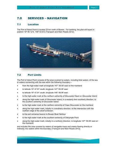
7.0 SERVICES – NAVIGATION<br />
7.1 Location<br />
The <strong>Port</strong> <strong>of</strong> <strong>Abbot</strong> <strong>Point</strong> is located 25 km north <strong>of</strong> Bowen. For berthing, the pilot will board in<br />
position 19º 48·12’S, 148º 03·6’E (Transport and Main Roads 2012).<br />
7.2 <strong>Port</strong> Limits<br />
The <strong>Port</strong> <strong>of</strong> <strong>Abbot</strong> <strong>Point</strong> consists <strong>of</strong> the area covered by waters, including tidal waters, <strong>of</strong> the sea<br />
or waters connecting with the sea within the following boundary—<br />
<br />
<br />
<br />
<br />
<br />
<br />
<br />
<br />
<br />
<br />
from the high-water mark at longitude 147° 59.06' east on the mainland<br />
to latitude 19° 47.91' south, longitude 147° 59.06' east<br />
to latitude 19° 47.91' south, longitude 148° 08.06' east<br />
to the high-water mark at the northern extremity <strong>of</strong> Gloucester Head on Gloucester Island<br />
along the high-water mark <strong>of</strong> Gloucester Island, in a westerly then southerly direction, to<br />
the southern extremity <strong>of</strong> Gloucester Island<br />
to the high-water mark at the northern extremity <strong>of</strong> Cape Gloucester on the mainland<br />
along the high-water mark, initially in a southerly direction, to the intersection with the<br />
northern edge <strong>of</strong> the wharf at Bowen<br />
to the port entrance beacon to Bowen Boat Harbour<br />
to the high-water mark at the southern extremity <strong>of</strong> Dalrymple <strong>Point</strong><br />
along the high-water mark, initially in a northerly direction, to longitude 147° 59.06' east on<br />
the mainland;<br />
and includes the area covered by waters <strong>of</strong> navigable rivers and creeks flowing directly or<br />
indirectly into waters within the boundary (Transport and Main Roads 2012).