Guideline - Department of Housing and Public Works - Queensland ...
Guideline - Department of Housing and Public Works - Queensland ...
Guideline - Department of Housing and Public Works - Queensland ...
You also want an ePaper? Increase the reach of your titles
YUMPU automatically turns print PDFs into web optimized ePapers that Google loves.
Step 4: Storm tide evacuation zones<br />
Map the storm tide evacuation zones for each <strong>of</strong> the six storm tide events.<br />
A property should be included in the evacuation zone when the storm tide event extends to the building on the<br />
property or the inundation isolates the property from the community.<br />
The storm tide event inundation levels shown on the map on the opposite page are essentially colour coded contour<br />
levels. Some properties are shown with two or more coloured zones. To avoid confusion the zones can be extended<br />
to the property boundary, so that a residential property is shown to be in a single zone. The exceptions are large<br />
properties with more than one residential building.<br />
The level <strong>of</strong> sea water inundation is neither uniform nor horizontal. The level will vary along the coastline depending<br />
upon the cyclone <strong>and</strong> its location along with the coastal bathymetry. On the east coast <strong>of</strong> Queensl<strong>and</strong> the storm tide is<br />
greatest south <strong>of</strong> the eye where the wind is blowing towards the shore. On the west coast <strong>of</strong> Cape York it is greatest to<br />
the north <strong>of</strong> the eye.<br />
In the beach front area, breaking ocean waves will run-up the beach <strong>and</strong> foreshore to levels above the predicted storm<br />
tide level. Waves will attack fore dunes or near shore structures <strong>and</strong> can cause considerable damage.<br />
Behind the beach front area, where the effect <strong>of</strong> ocean waves has decayed, the inundation level will depend upon:<br />
• the water depth<br />
• the duration <strong>of</strong> the peak storm tide<br />
• the obstruction to water flow by buildings, vegetation <strong>and</strong> topography.<br />
If there is sufficient time for the water to flow inl<strong>and</strong>, the inundation level inl<strong>and</strong> would eventually be the same as the<br />
water level at the coastline.<br />
Detailed engineering modelling can be used to determine the time-dependent inundation levels within the community<br />
for the various storm tide levels.<br />
Where such analysis has not been undertaken it is proposed that two evacuation levels are adopted for each storm<br />
tide event:<br />
• a level equal to the forecast storm tide height in the inl<strong>and</strong> area where the effect <strong>of</strong> ocean waves has decayed.<br />
• a higher level in the frontal area to allow for the effects <strong>of</strong> breaking ocean waves <strong>and</strong> run-up.<br />
The extent <strong>and</strong> increased level <strong>of</strong> the evacuation zone in the frontal area is dependent upon the storm tide event as<br />
the potential height <strong>of</strong> ocean waves depends on the water depth. Informed advice should be sought <strong>and</strong> realistic yet<br />
conservative estimates adopted for the width <strong>and</strong> increased level in the frontal area.<br />
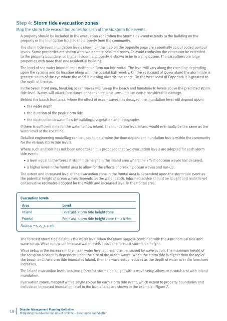
Evacuation levels<br />
Area<br />
Level<br />
Inl<strong>and</strong><br />
Forecast storm tide height zone<br />
Frontal Forecast storm tide height zone + n x 0.5m<br />
Note: n =1, 2, 3, 4 etc<br />
The forecast storm tide height is the water level when the storm surge is combined with the astronomical tide <strong>and</strong><br />
wave setup. Wave runup can increase water levels above the forecast storm tide height.<br />
Wave setup is the increase in the mean water level at the shoreline caused by wave action. The maximum height <strong>of</strong><br />
the setup on a beach is dependent upon the size <strong>of</strong> the ocean waves. When the storm tide is higher than the top <strong>of</strong><br />
the beach <strong>and</strong> the storm tide inundates inl<strong>and</strong>, then the wave setup reduces as the depth <strong>of</strong> water over the foreshore<br />
increases.<br />
The inl<strong>and</strong> evacuation levels assume a forecast storm tide height with a wave setup allowance consistent with inl<strong>and</strong><br />
inundation.<br />
Evacuation zones, mapped with a single colour for each storm tide event, which extent to property boundaries <strong>and</strong><br />
include an increased inundation level in the frontal area are shown in the example - Figure 7.<br />
18 |<br />
Disaster Management Planning <strong>Guideline</strong><br />
Mitigating the Adverse Impacts <strong>of</strong> Cyclone – Evacuation <strong>and</strong> Shelter


