updated planning report updated planning report - City of Guelph
updated planning report updated planning report - City of Guelph
updated planning report updated planning report - City of Guelph

You also want an ePaper? Increase the reach of your titles
YUMPU automatically turns print PDFs into web optimized ePapers that Google loves.
Updated Planning Report September 2008<br />
Proposed Lafarge/Silvercreek Development<br />
TABLE OF CONTENTS<br />
EXECUTIVE SUMMARY ................................................................................................... i<br />
1.0 INTRODUCTION and BACKGROUND ................................................................. 1<br />
2.0 SITE and REVISED PROPOSAL .......................................................................... 3<br />
2.1 The Subject Property ......................................................................................... 3<br />
2.2 Revised Redevelopment Concept ..................................................................... 3<br />
2.2.1 Original (2005) Scheme ............................................................................. 3<br />
2.2.2 Revised Scheme (November 2007) .......................................................... 4<br />
2.2.3 Refined Concept (2008) ............................................................................ 5<br />
3.0 UPDATED POLICY and REGULATORY CONTEXT ............................................ 7<br />
3.1 Provincial Policy Statement (2005) ................................................................... 7<br />
3.2 Growth Plan for Greater Golden Horseshoe (2006).......................................... 8<br />
3.3 <strong>City</strong> <strong>of</strong> <strong>Guelph</strong> Official Plan ............................................................................... 9<br />
3.3.1 Land Use Designations ............................................................................. 9<br />
3.3.2 Major Goals ............................................................................................... 9<br />
3.3.3 Community Form, Urban Form and Urban Design .................................... 9<br />
3.3.4 Development Staging .............................................................................. 11<br />
3.3.5 Community Improvement ........................................................................ 11<br />
3.3.6 Contaminated Properties ......................................................................... 12<br />
3.3.7 Natural Heritage and Environmental Impact ............................................ 12<br />
3.3.8 Central Business District ......................................................................... 12<br />
3.3.9 Commercial and Mixed Use .................................................................... 13<br />
3.3.10 Existing Site Designations ...................................................................... 18<br />
3.3.11 Official Plan Amendments ...................................................................... 18<br />
3.4 <strong>City</strong> <strong>of</strong> <strong>Guelph</strong> Zoning By-law .......................................................................... 19<br />
4.0 CITY STAFF RECOMMENDATIONS and CONCERNS ..................................... 21<br />
5.0 SYNOPSIS <strong>of</strong> UPDATED TECHNICAL STUDIES .............................................. 24<br />
5.1 Market Demand and Impact Analysis .............................................................. 24<br />
5.2 Traffic Impact Study ........................................................................................ 27<br />
5.3 Supplementary Stormwater Management Study ............................................. 29<br />
5.4 Environmental Impact Studies ......................................................................... 29<br />
5.4.1 EIS, October 2005 ................................................................................... 29<br />
5.4.2 Addendum I, May 2006 ........................................................................... 30<br />
5.4.3 Addendum II, Impacts <strong>of</strong> Revised Design and Tree Conservation Plan,<br />
November 2007 ....................................................................................... 31<br />
5.4.4 Addendum III, Response to <strong>Guelph</strong> EAC Comments April 9, 2008 ........ 32<br />
5.4.5 Addendum IV, Revised Impact Assessment Associated with Revised<br />
Storm Water Management Plan, August 2008 ........................................ 32<br />
5.5 Urban Design Guidelines ................................................................................ 33<br />
6.0 DISCUSSION and CONCLUSIONS .................................................................... 34<br />
6.1 Site Suitability .................................................................................................. 34<br />
6.2 Policy and Related Considerations ................................................................. 35<br />
6.2.1 Provincial Policy Statement (2005).......................................................... 35<br />
6.2.2 <strong>City</strong> Official Plan ...................................................................................... 37<br />
6.3 Remaining <strong>City</strong> Staff and Agency Concerns .................................................. 44<br />
6.4 Summary and Recommendations ................................................................... 46
Updated Planning Report September 2008<br />
Proposed Lafarge/Silvercreek Development<br />
List <strong>of</strong> Figures<br />
following page<br />
Figure 1 - Site Location 1<br />
Figure 2a - Revised Redevelopment Concept (2007) 4<br />
Figure 2b - Revised Redevelopment concept (2008) 5<br />
Figure 3 - <strong>Guelph</strong> Official Plan 9<br />
Schedule 1 – Land Use Plan<br />
Figure 4 - Existing Zoning 19
Updated Planning Report September 2008<br />
Proposed Lafarge/Silvercreek Development<br />
EXECUTIVE SUMMARY<br />
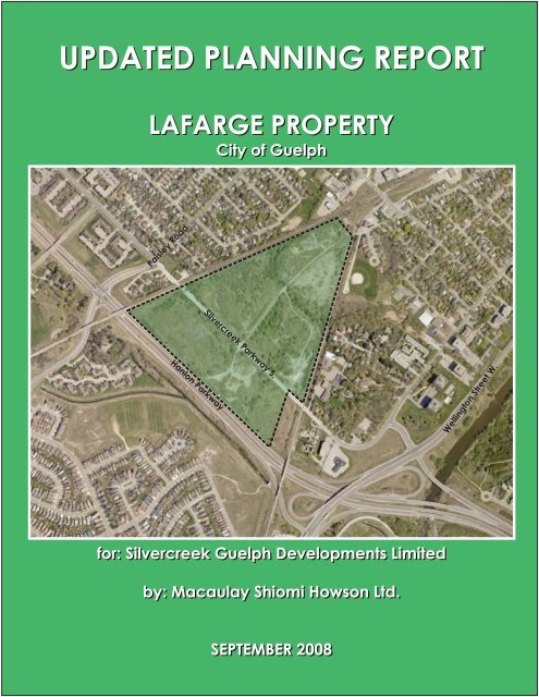
This <strong>planning</strong> <strong>report</strong> has been prepared by Macaulay Shiomi Howson Ltd., on behalf <strong>of</strong><br />
Silvercreek <strong>Guelph</strong> Developments Limited (“Silvercreek”.) Silvercreek is the prospective<br />
purchaser and prime proponent <strong>of</strong> a proposed mixed commercial redevelopment<br />
scheme on the 22 ha (54.4 ac.) vacant former Lafarge lands, located on the east side <strong>of</strong><br />
Hanlon Expressway, straddling Silvercreek Parkway south <strong>of</strong> Paisley Road, and known<br />
municipally as # 35 and 40 Silvercreek Parkway South.<br />
This <strong>report</strong> is intended to provide an <strong>updated</strong> review and analysis <strong>of</strong> the land use<br />
<strong>planning</strong> considerations relevant to a revised version <strong>of</strong> the originally-proposed mixed<br />
commercial redevelopment scheme on the subject lands. It has been prepared in the<br />
context <strong>of</strong> appeals to the Ontario Municipal Board <strong>of</strong> companion applications to the <strong>City</strong><br />
<strong>of</strong> <strong>Guelph</strong> for amendments to the Official Plan and Zoning By-law.<br />
By way <strong>of</strong> summary, the revised redevelopment concept is illustrated on Figure 2A –<br />
Revised Redevelopment Concept (2007) in the body <strong>of</strong> this <strong>report</strong>, and provides a<br />
range <strong>of</strong> commercial land uses reflective <strong>of</strong> the requested re-designation to “Mixed Use<br />
Node”, as part <strong>of</strong> the <strong>City</strong>’s revised planned commercial structure.<br />
Key components include a revised retail and service commercial node <strong>of</strong> 37,160 sq. m<br />
(400,00 sq. ft.) which includes two primary large-format retail outlets (home improvement<br />
centre/furniture store and warehouse membership club.) The prospective warehouse<br />
membership club (WMC) would serve as an anchor use for this commercial<br />
development, and would represent the first WMC facility in the <strong>Guelph</strong> context.<br />
Also proposed in the development would be a variety <strong>of</strong> other medium and smaller retail<br />
uses, arrayed around a central “village marketplace” straddling Silvercreek Parkway.<br />
The former proposal for a new public park east <strong>of</strong> Howitt Creek has been revised to a<br />
passive private open space accommodating substantially revised stormwater<br />
management facilities.<br />
This <strong>report</strong> addresses relevant policy considerations arising from the Provincial Policy<br />
Statement (PPS), 2005. The PPS “…supports a comprehensive, integrated and longterm<br />
approach to <strong>planning</strong>…[which]…recognizes linkages among policy areas.” In<br />
particular, it focuses on building strong communities, protecting the environment and<br />
resources, and supporting a strong economy. It contains policies which, among others,<br />
provide for the protection <strong>of</strong> employment areas and the long term health and<br />
competitiveness <strong>of</strong> the economic base.<br />
As set out in Section 3.1 <strong>of</strong> this <strong>report</strong>, the PPS speaks to promotion <strong>of</strong> efficient<br />
development and land use patterns, provision for an appropriate range and mix <strong>of</strong><br />
employment opportunities, encouragement <strong>of</strong> intensification and redevelopment to assist<br />
municipalities in meeting long-term needs, promotion <strong>of</strong> economic development and<br />
competitiveness, and supporting long-term economic prosperity. This <strong>planning</strong> <strong>report</strong><br />
concludes, as detailed in Section 6.2.1, that the revised Silvercreek proposal is<br />
consistent with all <strong>of</strong> these policy directions.<br />
In particular, the subject proposal will facilitate the viable redevelopment <strong>of</strong> derelict,<br />
serviceable industrial lands, which will constitute a productive re-use <strong>of</strong> this vacant,<br />
centrally-located parcel within <strong>Guelph</strong>’s existing urban context. It will also help to<br />
i
Updated Planning Report September 2008<br />
Proposed Lafarge/Silvercreek Development<br />
strengthen and diversify <strong>Guelph</strong>’s economic base, most notably through the introduction<br />
<strong>of</strong> a new regional retail operation (warehouse membership club) not currently in the<br />
<strong>Guelph</strong> market. Based on the findings <strong>of</strong> the <strong>updated</strong> market study, the proposal can be<br />
accommodated without detriment to the overall function or economic vitality <strong>of</strong> <strong>Guelph</strong>’s<br />
downtown. In addition, the subject property is a vacant brownfield site, now remediated<br />
and proposed for productive redevelopment and re-use.<br />
The PPS also addresses the issue <strong>of</strong> employment land conversion. For a number <strong>of</strong><br />
reasons which are also discussed in detail in Section 6.2.1 <strong>of</strong> this <strong>report</strong>, it is our view<br />
that the subject proposal does not represent “conversion” <strong>of</strong> employment lands to nonemployment<br />
uses, and thus does not require a comprehensive review as a prerequisite<br />
to its development.<br />
The <strong>City</strong>’s Official Plan contains a number <strong>of</strong> goals, principles, objectives and policies<br />
which are relevant to the subject site and proposal. These are canvassed at length in<br />
Sections 3.2 and 6.2.2 <strong>of</strong> this <strong>report</strong>. It is our overall conclusion that the revised<br />
Silvercreek proposal, together with the <strong>updated</strong> technical studies which support the<br />
requested re-designation and rezoning for the mixed commercial development concept<br />
described in this <strong>report</strong>, is consistent with the general principles and specific policy<br />
requirements <strong>of</strong> the <strong>City</strong> <strong>of</strong> <strong>Guelph</strong> Official Plan.<br />
In particular, it meets the Plan’s notable major goals <strong>of</strong> protecting and enhancing the<br />
natural environment, directing development where municipal infrastructure is most<br />
readily available, and maintains the downtown’s primary role within the <strong>City</strong>’s urban<br />
structure. Furthermore, it represents compatible intensification and redevelopment <strong>of</strong> a<br />
large, existing, under-utilized industrial parcel, and will facilitate the remediation <strong>of</strong> an<br />
existing contaminated brownfield parcel which is among those particularly targeted by<br />
the <strong>City</strong> for community improvement. Natural heritage and environmental impact<br />
considerations have been exhaustively documented and addressed. The geography<br />
and setting <strong>of</strong> the site will minimize potential land use conflicts, and serve to facilitate a<br />
distinct identity.<br />
Commercial policy requirements applicable to the requested “Mixed Use Node”<br />
designation have been addressed, both in this <strong>planning</strong> <strong>report</strong> and in the associated<br />
<strong>updated</strong> technical studies on market impact, urban design, traffic impact, stormwater<br />
management and environmental impact. In particular, the range <strong>of</strong> impact studies<br />
required to support the designation <strong>of</strong> a new (or expanded) Mixed Use Node has been<br />
appropriately addressed, in our view, and any related conditions or requirements have<br />
been identified in those studies or will be supplemented by the completion <strong>of</strong> ongoing<br />
technical agency review, as well as subsequent site plan approval requirements.<br />
In addition, substantial discussion is contained in Section 6.2.2 <strong>of</strong> this <strong>report</strong> on the<br />
Plan’s general criteria to be addressed for Official Plan amendments, and it is our overall<br />
conclusion that they are appropriately addressed. These criteria cover a range <strong>of</strong><br />
<strong>planning</strong> considerations, including: conformity to the Plan’s goals and objectives; site<br />
suitability and use compatibility; market feasibility <strong>of</strong> and need for the proposed use;<br />
availability <strong>of</strong> other designated areas; impacts on infrastructure and the natural<br />
environment; and, financial implications.<br />
Sections 4 <strong>of</strong> this <strong>report</strong> contains a summary <strong>of</strong> the remaining concerns held by <strong>City</strong> staff<br />
and interested agencies, and our detailed responses to those are found in Section 6.3, in<br />
ii
Updated Planning Report September 2008<br />
Proposed Lafarge/Silvercreek Development<br />
the context <strong>of</strong> the <strong>updated</strong> supporting technical studies, as well as the ongoing technical<br />
agency review.<br />
In summary, based on the analysis and conclusions <strong>of</strong> this <strong>updated</strong> <strong>planning</strong> <strong>report</strong>, and<br />
supported by the related technical studies, including the <strong>updated</strong> ones summarized<br />
herein, it is our pr<strong>of</strong>essional opinion that the revised development proposal and related<br />
applications for Official Plan amendment and rezoning warrant approval on appropriate<br />
and relevant land use <strong>planning</strong> grounds, subject to a number <strong>of</strong> appropriate<br />
implementation recommendations which are detailed in section 6.4 <strong>of</strong> this <strong>planning</strong><br />
<strong>report</strong>.<br />
iii
Updated Planning Report September 2008<br />
Proposed Lafarge/Silvercreek Development<br />
1.0 INTRODUCTION and BACKGROUND<br />
This <strong>planning</strong> <strong>report</strong> has been prepared by Macaulay Shiomi Howson Ltd., on behalf <strong>of</strong><br />
Silvercreek <strong>Guelph</strong> Developments Limited (“Silvercreek”.) Silvercreek is the prospective<br />
purchaser and prime proponent <strong>of</strong> a proposed mixed commercial redevelopment<br />
scheme on the 22 ha (54.4 ac.) vacant former Lafarge lands, located on the east side <strong>of</strong><br />
Hanlon Expressway, straddling Silvercreek Parkway south <strong>of</strong> Paisley Road, and known<br />
municipally as # 35 and 40 Silvercreek Parkway South.<br />
The location <strong>of</strong> the subject site is depicted on the accompanying map Figure 1 – Site<br />
Location.<br />
This <strong>report</strong> is intended to provide an <strong>updated</strong> review and analysis <strong>of</strong> the land use<br />
<strong>planning</strong> considerations relevant to a revised version <strong>of</strong> the originally-proposed mixed<br />
commercial redevelopment scheme on the subject lands. It has been prepared in the<br />
context <strong>of</strong> appeals to the Ontario Municipal Board <strong>of</strong> companion applications to the <strong>City</strong><br />
<strong>of</strong> <strong>Guelph</strong> for amendments to the Official Plan and Zoning By-law.<br />
This <strong>planning</strong> <strong>report</strong> is an <strong>updated</strong> successor to the original Planning Study (dated<br />
September 2005) on the subject applications prepared by Black, Shoemaker, Robinson<br />
& Donaldson Limited. That earlier <strong>report</strong> was part <strong>of</strong> a package <strong>of</strong> supporting materials<br />
which accompanied the original submission <strong>of</strong> the subject applications in November<br />
2005. Since that initial submission, these applications have been in process and under<br />
consideration by the <strong>City</strong> <strong>of</strong> <strong>Guelph</strong>.<br />
The applicant/proponent Silvercreek appealed to the OMB in July 2007, on the basis <strong>of</strong> a<br />
lack <strong>of</strong> decision by <strong>Guelph</strong> Council on the subject applications within the specified timeframes<br />
in the Planning Act. Nonetheless, processing by the <strong>City</strong> has continued,<br />
including agency review and comments, and further refinements to the development<br />
concept, in response to comments and concerns from interested agencies and the<br />
public.<br />
A formal re-submission, together with numerous supporting technical <strong>report</strong>s, took place<br />
in November 2007, and further discussions with agencies have ensued, leading to<br />
additional refinements <strong>of</strong> that November 2007 development concept.<br />
In the ensuing months since that formal re-submission, <strong>City</strong> staff’s processing <strong>of</strong> the<br />
applications has continued, primarily to facilitate a Council position in the context <strong>of</strong> the<br />
aforementioned OMB appeal proceedings. That staff process has included<br />
circulation/comments from technical agencies and additional public input opportunities.<br />
It culminated in a June 3, 2008 staff <strong>report</strong> in which staff recommended that Council not<br />
support the requested amendments as proposed, for reasons which are detailed later in<br />
this <strong>report</strong>.<br />
This <strong>planning</strong> <strong>report</strong> is focused upon the latest version <strong>of</strong> the late 2007 concept, as<br />
further refined based upon the additional technical work done in 2008 and summarized<br />
in a later section <strong>of</strong> this <strong>report</strong>. As noted above, it is intended to provide an <strong>updated</strong><br />
<strong>planning</strong> evaluation which reflects not only the revised development scheme, but also<br />
the changed Official Plan policy context since the original applications were submitted in<br />
2005.<br />
1
Updated Planning Report September 2008<br />
Proposed Lafarge/Silvercreek Development<br />
The key policy differences arise from the subsequent completion <strong>of</strong> the <strong>City</strong>’s<br />
Commercial Policy Review, and implementation <strong>of</strong> the resultant Official Plan changes<br />
through the adoption and approval <strong>of</strong> OPA # 29. Those changes are now incorporated<br />
in the latest consolidation <strong>of</strong> the <strong>Guelph</strong> Official Plan and are addressed in detail in this<br />
<strong>report</strong>.<br />
By way <strong>of</strong> summary, the revised redevelopment concept is illustrated on Figure 2A –<br />
Revised Redevelopment Concept (2007) in the body <strong>of</strong> this <strong>report</strong>, and provides a<br />
range <strong>of</strong> commercial land uses reflective <strong>of</strong> the requested re-designation to “Mixed Use<br />
Node”, as part <strong>of</strong> the <strong>City</strong>’s revised planned commercial structure.<br />
Key components include a revised retail and service commercial node <strong>of</strong> 37,160 sq. m<br />
(400,00 sq. ft.) which includes two primary large-format retail outlets (home improvement<br />
centre/furniture store and warehouse membership club.) The prospective warehouse<br />
membership club (WMC) would serve as an anchor use for this commercial<br />
development, and would represent the first WMC facility in the <strong>Guelph</strong> context.<br />
Also proposed in the development would be a variety <strong>of</strong> other medium and smaller retail<br />
uses, arrayed around a central “village marketplace” straddling Silvercreek Parkway.<br />
The former proposal for a new public park east <strong>of</strong> Howitt Creek has been revised to a<br />
passive private open space accommodating substantially revised stormwater<br />
management facilities. The revised concept also re-confirms the proponent’s deletion <strong>of</strong><br />
the original direct connection proposed to Hanlon Expressway, as the <strong>City</strong> had been<br />
advised in 2006. The alternative access scheme focuses on a grade-separated<br />
Silvercreek Parkway crossing <strong>of</strong> the main CNR rail line to the north <strong>of</strong> the site.<br />
The key matters addressed by this <strong>planning</strong> analysis include a description <strong>of</strong> the site and<br />
its physical context, the details <strong>of</strong> the revised proposal, and the <strong>updated</strong> policy and<br />
regulatory framework which apply. In addition, this <strong>report</strong> synthesizes the results <strong>of</strong><br />
supplementary or <strong>updated</strong> supporting technical studies (including retail market impact,<br />
traffic impact, stormwater management and environmental impact considerations), and<br />
analyses the land use <strong>planning</strong> implications and merits <strong>of</strong> the proposal.<br />
The balance <strong>of</strong> this <strong>planning</strong> <strong>report</strong> comprises the following sections:<br />
‣ Section 2: SITE and REVISED PROPOSAL<br />
‣ Section 3: UPDATED POLICY and REGULATORY CONTEXT<br />
‣ Section 4: CITY STAFF RECOMMENDATIONS/CONCERNS<br />
‣ Section 5: SYNOPSIS <strong>of</strong> UPDATED TECHNICAL STUDIES<br />
‣ Section 6: DISCUSSION and CONCLUSIONS<br />
2
Updated Planning Report September 2008<br />
Proposed Lafarge/Silvercreek Development<br />
2.0 SITE and REVISED PROPOSAL<br />
2.1 The Subject Property<br />
The site which is the subject <strong>of</strong> the applications under appeal remains the same as<br />
constituted at the time <strong>of</strong> the original 2005 application. It has a gross area <strong>of</strong> about 22<br />
ha (55.4 ac.), and is triangular in configuration.<br />
The subject property is located approximately two kms from <strong>Guelph</strong>’s downtown core,<br />
straddling Silvercreek Parkway, which is a two-lane north/south city street interrupted by<br />
the CNR line at the north edge <strong>of</strong> the site. The property directly abuts the east side <strong>of</strong><br />
Hanlon Expressway, a four-lane, limited-access divided highway which is also<br />
designated as Provincial Highway 6. The subject property is defined on its northeast<br />
and southeast sides by rail lines, the former being a main CNR line, and the latter being<br />
a secondary CNR line which is leased by the Goderich-Exeter Railway (GEXR.)<br />
The site was formerly owned and used by Lafarge Canada as a gravel quarry (until the<br />
mid-1970’s), and more recently, for a concrete block manufacturing operation, which<br />
ceased in 1994. Today the lands remain vacant, bisected by Howitt Creek, which flows<br />
from north to south in a relatively narrow and well-vegetated valley intended to be<br />
protected from development with an appropriate buffer zone; the creek itself is<br />
approximately 6 m (20 ft.) below the surrounding site elevation. Howitt Creek carries<br />
substantial stormwater flow from the Alma Drain storm sewer system north <strong>of</strong> the site,<br />
through the property and under the GEXR bridge culvert at the south edge <strong>of</strong> the site.<br />
Apart from the creek valley, the overall topography <strong>of</strong> the site is generally flat, and it sits<br />
lower than the adjacent rail lines and the neighbourhoods beyond, both to the north and<br />
the south. There are embankments at both railways which vary in height between 3 m<br />
(10 ft.) and 6 m (20 ft.), with trees along both embankments. Otherwise, site vegetation<br />
is generally non-native, pioneering, shrubby and successional in nature, with some<br />
specimen trees in evidence, including a large oak located immediately adjacent to<br />
Silvercreek Parkway .<br />
Adjacent uses to the north <strong>of</strong> the CNR main line are low density residential in nature,<br />
and include: single and semi-detached dwellings either side <strong>of</strong> the existing stub-end <strong>of</strong><br />
Silvercreek Parkway at the northwest corner <strong>of</strong> the site; and, Goldie Park, a small<br />
passive neighbourhood park which adjoins Paisley Road Public School to the northeast<br />
<strong>of</strong> the site. Existing uses to the south <strong>of</strong> the GEXR rail line comprise a mix <strong>of</strong> low density<br />
residential, Howitt Park (an active park with parking), the <strong>Guelph</strong> Bible Chapel and<br />
Conference Centre, a mid-rise (5-storey) apartment building and the Manor Hotel.<br />
2.2 Revised Redevelopment Concept<br />
2.2.1 Original (2005) Scheme<br />
As previously noted, the proposed redevelopment concept for the subject lands has<br />
evolved from its original 2005 form.<br />
That original scheme, as applied for in November 2005, revolved around a mixed<br />
community commercial “campus”, with a total retail and service commercial floor space<br />
3
Updated Planning Report September 2008<br />
Proposed Lafarge/Silvercreek Development<br />
<strong>of</strong> 41,800 sq. m (450,000 sq. ft.), including the potential for some <strong>of</strong>fice space. A<br />
“village” concept was proposed, mixing both neighbourhood-type facilities with larger<br />
format users not suited to a downtown setting. From an access perspective, this original<br />
concept was premised on a direct connection to/from the northbound side <strong>of</strong> Hanlon<br />
Expressway, with additional access to/from the south via a widened Silvercreek<br />
Parkway.<br />
The original concept also proposed the preservation <strong>of</strong> Howitt Creek and its associated<br />
valley, and included provision for a new public park on the portion <strong>of</strong> the site east <strong>of</strong> the<br />
creek, which totals about 4.4 ha (10.8 ac.) in area.<br />
Consistent with the then-prevailing Official Plan context, the initial application sought<br />
approval for an Official Plan amendment which would re-designate the site “Community<br />
Commercial” (with “Non-Core Greenlands Overlay” for the Howitt Creek) and “Open<br />
Space” (park land) to the east <strong>of</strong> the creek, with site-specific permission for a mixed<br />
commercial node <strong>of</strong> up to 41,800 sq. m (450,000 sq. ft.) in size.<br />
A parallel application for rezoning sought a “Community Commercial (CC)” Zone on the<br />
developable portion <strong>of</strong> the site, west <strong>of</strong> the creek, a “Floodplain Lands (FL)” Zone on<br />
Howitt Creek and its associated valleyland, and “Community Park (P.3)” Zone on the<br />
portion east <strong>of</strong> the creek. That rezoning would be on a special (site-specific) basis, to<br />
the maximum aggregate floor space proposed.<br />
The above-noted Official Plan land use designation originally requested at the time <strong>of</strong><br />
the 2005 application was modified by Silvercreek in conjunction with their appeals to the<br />
OMB, in July 2007. That modified designation request was driven by the changes in the<br />
underlying Official Plan policy framework which had resulted from the <strong>City</strong>’s completion<br />
<strong>of</strong> the Commercial Policy Review (CPR) and the adoption <strong>of</strong> OPA 29, subsequent to the<br />
original Silvercreek application.<br />
OPA 29 introduced comprehensive commercial structure changes into the <strong>Guelph</strong><br />
Official Plan, flowing from the results <strong>of</strong> the CPR process -- with respect to both<br />
governing policies and commercial land use designations. Since the originallyrequested<br />
“Community Commercial” land use designation had ceased to exist due to the<br />
approval <strong>of</strong> OPA 29, Silvercreek revised their request in July 2007 (in the context <strong>of</strong> their<br />
appeals) to the logical land use category under the new commercial policy regime --<br />
“Mixed Use Node.”<br />
2.2.2 Revised Scheme (November 2007)<br />
As noted, in November <strong>of</strong> 2007, a revised development concept was submitted to the<br />
<strong>City</strong>, supported by <strong>updated</strong> or additional supporting technical <strong>report</strong>s, in response to<br />
technical issues and public comments/concerns which had emerged through the<br />
application review process. This revised submission was also intended to foster<br />
continued dialogue between Silvercreek and the <strong>City</strong>, in the context <strong>of</strong> the OMB appeals<br />
which by then had been submitted, in the hope <strong>of</strong> narrowing or even eliminating the<br />
issues <strong>of</strong> concern.<br />
The November 2007 concept is illustrated on the accompanying Figure 2A – Revised<br />
Redevelopment Concept (2007), and differed from the original 2005 scheme in the<br />
following key ways:<br />
4
Updated Planning Report September 2008<br />
Proposed Lafarge/Silvercreek Development<br />
• based on a refined marketing concept which, in part, responded to the findings <strong>of</strong><br />
the <strong>City</strong>’s market peer reviewer, the overall scale <strong>of</strong> the retail/service commercial<br />
component was reduced to 37,160 sq. m (400,00 sq. ft.);<br />
• two principal large-format retail operators were now specifically proposed -- a<br />
warehouse membership club and a home improvement/furniture operation --<br />
adjacent to the respective abutting rail lines, together with a range <strong>of</strong> medium<br />
and small retail/service commercial uses;<br />
• in light <strong>of</strong> MTO’s prohibition on any access directly to/from Hanlon Expressway,<br />
site access was formally revised to focus on a widened and improved Silvercreek<br />
Parkway, most notably including a connection north and south <strong>of</strong> the CNR<br />
mainline via a grade separation; and,<br />
• the urban design concept was revised to reflect the following key characteristics:<br />
o focus the commercial development around an urban “village marketplace”<br />
straddling Silvercreek Parkway, based on smaller retail buildings with twostorey<br />
massing and associated outdoor amenity spaces defining a primary<br />
“gateway” intersection providing access to the development from Silvercreek<br />
Parkway;<br />
o locate the large-format retail structures on the least-visible parts <strong>of</strong> the site,<br />
and buffered with vegetation;<br />
o provision <strong>of</strong> an internal private roadway (grid/block) pattern intended to<br />
facilitate intensification over time;<br />
o primary pedestrian routes which converge on the village marketplace,<br />
including provision <strong>of</strong> an east/west greenway between Howitt Creek and the<br />
village marketplace; and,<br />
o connection <strong>of</strong> Silvercreek Parkway to the north (via a grade separation at the<br />
CNR) and enhancement with double rows <strong>of</strong> trees, transit, on-street parking,<br />
broad sidewalks and bike lanes.<br />
The November 2007 revised concept continued to protect the existing Howitt Creek and<br />
its associated valleylands, and carried forward the specific proposal for a new public<br />
park (“Junction Park”) on the lands east <strong>of</strong> the creek valley. A revised stormwater<br />
management concept was also put forward to manage <strong>of</strong>f-site, upstream storm flows in<br />
Howitt Creek during major storm events; this involved flood storage (temporary<br />
stormwater detention) within a portion <strong>of</strong> the proposed public park east <strong>of</strong> the Creek.<br />
2.2.3 Refined Concept (2008)<br />
The November 2007 scheme has been further refined as additional processing has<br />
occurred, and further technical work has been completed to address <strong>City</strong> and other<br />
agency concerns. A copy <strong>of</strong> that further refinement is shown overleaf, as Figure 2B --<br />
Revised Redevelopment Concept (2008).<br />
5
Updated Planning Report September 2008<br />
Proposed Lafarge/Silvercreek Development<br />
Of particular note in that regard is the additional stormwater management analysis which<br />
was necessitated by the technical questions and concerns <strong>of</strong> both the <strong>City</strong> and the<br />
GRCA, particularly with regard to upstream and downstream impacts. That additional<br />
stormwater analysis has led to the conclusion that most <strong>of</strong> the area <strong>of</strong> the proposed<br />
“Junction Park” east <strong>of</strong> Howitt Creek is required for storm detention during major (100-<br />
year) storm events, largely owing to a clearer understanding <strong>of</strong> the existing upstream<br />
(<strong>of</strong>f-site) flow entering the site from the existing storm drainage system serving the<br />
neighbourhoods to the north.<br />
Hence, given these revised stormwater conclusions, coupled with the <strong>City</strong>’s and CNR’s<br />
design concerns regarding public access and public safety for park users (given the<br />
park’s proximity to the rail lines), on balance, it would now appear that the proposed<br />
open space lands east <strong>of</strong> the creek, during major storm events, would not be acceptable<br />
to the <strong>City</strong> as a public park dedication. Although it is not their preference, Silvercreek<br />
will instead meet parkland requirements on a cash-in-lieu basis, in order to<br />
accommodate this preferred solution to the upstream stormwater management issue.<br />
Since this stormwater facility is essentially remedial in nature – that is, it is geared to<br />
resolving the existing storm drainage flow which arises wholly <strong>of</strong>f-site from the area to<br />
the north and is not intended to handle any <strong>of</strong> the storm flows generated by the<br />
proposed commercial development west <strong>of</strong> the creek -- it would be logical for this open<br />
space/stormwater management area east <strong>of</strong> the creek to be taken into the <strong>City</strong>’s<br />
ownership through conveyance. Under that scenario, the logical zoning category for the<br />
open space/stormwater management lands east <strong>of</strong> the creek would then be<br />
“Conservation Land (P.1) Zone”<br />
Also <strong>of</strong> note are the additional (<strong>updated</strong>) traffic impact and retail market analyses<br />
intended to address continued agency concerns. In particular, the <strong>updated</strong> market study<br />
now provides analyses and impact conclusions which are expressly directed to the<br />
policy “tests” contained in the <strong>City</strong>’s Official Plan as now consolidated to incorporate the<br />
results <strong>of</strong> the completed “Commercial Policy Review” (OPA 29.)<br />
A summary <strong>of</strong> all <strong>of</strong> the key findings from the foregoing <strong>updated</strong> technical studies is<br />
contained in a later section <strong>of</strong> this <strong>planning</strong> <strong>report</strong>.<br />
6
Updated Planning Report September 2008<br />
Proposed Lafarge/Silvercreek Development<br />
3.0 UPDATED POLICY and REGULATORY CONTEXT<br />
The subject site is affected by a number <strong>of</strong> existing land use policies and zoning<br />
provisions which are germane to a consideration <strong>of</strong> the revised subject applications. In<br />
order to provide an appropriate context in which to weigh the merits <strong>of</strong> the revised<br />
development applications, these pertinent provisions are set out in some detail in the<br />
following subsections. Their implications for the proposal are then analyzed and<br />
discussed in Section 6 <strong>of</strong> this <strong>updated</strong> <strong>planning</strong> <strong>report</strong>.<br />
3.1 Provincial Policy Statement (2005)<br />
The Provincial Policy Statement (PPS) provides policy direction on matters <strong>of</strong> provincial<br />
interest related to land use <strong>planning</strong> and development. All land use <strong>planning</strong> decisions<br />
must be consistent with the PPS, as dictated by the provisions in Section 3 <strong>of</strong> the<br />
Planning Act.<br />
The current version <strong>of</strong> the PPS came into force on March 1, 2005 and “…supports a<br />
comprehensive, integrated and long-term approach to <strong>planning</strong>…[which]…recognizes<br />
linkages among policy areas.” In particular, it focuses on building strong communities,<br />
protecting the environment and resources, and supporting a strong economy. It contains<br />
policies which, among others, provide for the protection <strong>of</strong> employment areas and the<br />
long term health and competitiveness <strong>of</strong> the economic base.<br />
The following specific policies are <strong>of</strong> some relevance to the subject proposal:<br />
1.1.1 Healthy, liveable and safe communities are sustained by:<br />
a) promoting efficient development and land use patterns which sustain the<br />
financial well-being <strong>of</strong> the Province and municipalities over the long term;<br />
b) accommodating an appropriate range and mix <strong>of</strong> residential, employment<br />
(including industrial, commercial and institutional uses), recreational and<br />
open space uses to meet long-term needs;<br />
c) avoiding development and land use patterns which may cause environmental<br />
or public health and safety concerns;<br />
1.1.2 Sufficient land shall be made available through intensification and redevelopment<br />
and, if necessary, designated growth areas, to accommodate an appropriate<br />
range and mix <strong>of</strong> employment opportunities, housing and other land uses to meet<br />
projected needs for a time horizon <strong>of</strong> up to 20 years….<br />
1.1.3.3 Planning authorities shall identify and promote opportunities for intensification<br />
and redevelopment where this can be accommodated taking into account<br />
existing building stock or areas, including brownfield sites, and the availability<br />
<strong>of</strong> suitable existing or planned infrastructure and public service facilities<br />
required to accommodate projected needs.<br />
1.3.1 Planning authorities shall promote economic development and<br />
competitiveness by:<br />
7
Updated Planning Report September 2008<br />
Proposed Lafarge/Silvercreek Development<br />
a) providing for an appropriate mix and range <strong>of</strong> employment (including<br />
industrial, commercial, and institutional uses) to meet long term needs;<br />
b) providing opportunities for a diversified economic base, including maintaining<br />
a range and choice <strong>of</strong> suitable sites for employment uses which support a<br />
wide range <strong>of</strong> economic activities and ancillary uses, and take into account<br />
the needs <strong>of</strong> existing and future businesses;<br />
c) <strong>planning</strong> for, protecting and preserving employment areas for current and<br />
future uses; and,<br />
d) ensuring the necessary infrastructure is provided to support current and<br />
projected needs.<br />
1.3.2 Planning authorities may permit conversions <strong>of</strong> lands within employment areas to<br />
non-employment uses through a comprehensive review, only where it has been<br />
demonstrated that the land is not required for employment purposes over the<br />
long term and that there is a need for the conversion.<br />
1.7.1 Long-term economic prosperity should be supported by:<br />
a) optimizing the long-term availability and use <strong>of</strong> land, resources, infrastructure<br />
and public service facilities;<br />
b) maintaining, and where possible, enhancing the vitality and viability <strong>of</strong><br />
downtowns and mainstreets;<br />
c) promoting the redevelopment <strong>of</strong> brownfield sites;<br />
The implementation provisions <strong>of</strong> the PPS (in section 4.0) acknowledge that Official<br />
Plans are ”…the most important vehicle for implementation <strong>of</strong> this Provincial Policy<br />
Statement.” As such, Official Plans “…shall identify provincial interests and set out<br />
appropriate land use designations and policies…[and]…provide clear, reasonable and<br />
attainable policies to protect provincial interests and direct development to suitable<br />
areas.”<br />
It is noted that the term “Employment Area” is used above in Policy 1.3.2, and is defined<br />
by the PPS as follows: “…means those areas designated in an <strong>of</strong>ficial plan for clusters <strong>of</strong><br />
business and economic activities including, but not limited to, manufacturing,<br />
warehousing, <strong>of</strong>fices and associated retail and ancillary facilities.” (emphasis added.)<br />
The applicability <strong>of</strong> 1.3.2 to major retail proposals on employment lands under the 2005<br />
PPS will be discussed in further detail in Section 6.2.1 <strong>of</strong> this <strong>report</strong>.<br />
3.2 Growth Plan for Greater Golden Horseshoe (2006)<br />
The Growth Plan for the Greater Golden Horseshoe (“Growth Plan”) is a major policy<br />
document approved by the Province in June 2006 under the Places to Grow Act. The<br />
Growth Plan represents another senior level policy that is <strong>of</strong> some significance for<br />
employment lands, for those development applications which fall under its purview.<br />
8
Updated Planning Report September 2008<br />
Proposed Lafarge/Silvercreek Development<br />
However, the Silvercreek application is not subject to the provisions <strong>of</strong> the Growth Plan,<br />
by virtue <strong>of</strong> the original application date in 2005 which pre-dated the in-force date <strong>of</strong> the<br />
Growth Plan, and the related transitional regulations which clearly indicate that prior<br />
applications are exempt from the Growth Plan’s provisions.<br />
3.3 <strong>City</strong> <strong>of</strong> <strong>Guelph</strong> Official Plan<br />
This discussion <strong>of</strong> the <strong>City</strong>’s Official Plan is based upon the latest consolidation<br />
available, dated November 2006, and incorporating the provisions <strong>of</strong> OPA 29, which<br />
reflected the outcome <strong>of</strong> the <strong>City</strong>’s Commercial Policy Review.<br />
3.3.1 Land Use Designations<br />
At a site-specific level, as shown on the accompanying Figure 3 -- Schedule 1 – Land<br />
Use Plan, the Plan’s land use designation on the site is “Industrial” on Schedule 1 –<br />
Land Use Plan, and it is superimposed with a “Non-Core Greenlands Overlay”,<br />
applicable to Howitt Creek and its related valley/floodplain which bisects the site in a<br />
north/south direction. The particulars <strong>of</strong> these designations are discussed later in this<br />
section <strong>of</strong> the <strong>report</strong>.<br />
3.3.2 Major Goals<br />
From a more general perspective, the Plan’s “Major Goals” are found under “Basis” in<br />
Section 2.3, among which the following are seen to be particularly germane in this<br />
instance:<br />
“2. Promote a compact and staged development pattern to maintain the distinct<br />
urban/rural physical separation and to avoid sprawl and premature development.”<br />
“4. Direct development to those areas where municipal services and related physical<br />
infrastructure are most readily or can be made available, considering existing<br />
land uses, natural heritage features, development constraints, development costs<br />
and related factors.”<br />
“11. Respect and encourage the protection and enhancement <strong>of</strong> the natural<br />
environment, other distinctive features <strong>of</strong> the landscape and the associated<br />
ecological functions to support a healthy and diverse ecosystem both within and<br />
beyond <strong>City</strong> limits.”<br />
“14. Develop an appropriate framework to facilitate the full range <strong>of</strong> commercial uses<br />
consistent with the needs <strong>of</strong> the <strong>City</strong>’s population and employment base and<br />
supportive <strong>of</strong> the <strong>City</strong>’s transportation objectives.”<br />
“15. Maintain and strengthen the role <strong>of</strong> the Central Business District (Downtown) as<br />
a major focal area for investment, employment and residential uses…”<br />
3.3.3 Community Form, Urban Form and Urban Design<br />
Section 3 <strong>of</strong> the Plan addresses “General Policies”, and in 3.2, includes a discussion <strong>of</strong><br />
“Community Form”, which includes the following relevant “General Development<br />
Objective”:<br />
9
Updated Planning Report September 2008<br />
Proposed Lafarge/Silvercreek Development<br />
“a)<br />
To guide the direction, location, scale and timing <strong>of</strong> growth in order to ensure<br />
compact, orderly and sustainable development and to minimize the cost <strong>of</strong><br />
municipal services and related infrastructure.”<br />
Section 3.3.1 on “Urban Form” policies includes the following <strong>of</strong> relevance intended to<br />
“…promote a compact urban form and gradual expansion <strong>of</strong> existing urban<br />
development…”:<br />
“a)<br />
“d)<br />
“e)<br />
“i)<br />
Encouraging intensification and redevelopment <strong>of</strong> existing urban areas in a<br />
manner that is compatible with existing built form;”<br />
Encouraging intensification <strong>of</strong> residential, commercial, industrial and institutional<br />
areas to maximize efficient use <strong>of</strong> municipal services;”<br />
Promoting mixed uses in appropriate locations throughout the <strong>City</strong> to provide<br />
residents opportunities to live, learn, work, shop, recreate, gather and worship in<br />
close proximity.”<br />
Promoting reuse, revitalization and redevelopment <strong>of</strong> commercial or industrial<br />
sites that are under-utilized or no longer in use;”<br />
The Plan’s discussion <strong>of</strong> “Urban Design” is found in Section 3.6, with the following<br />
“Objectives” <strong>of</strong> particular note:<br />
“c)<br />
“h)<br />
To practice environmentally sustainable urban development by adhering to urban<br />
design principles that respect the natural features, reinforce natural processes<br />
and conserve natural resources.”<br />
To encourage compatibility and quality in the built environment while allowing for<br />
a diverse expression <strong>of</strong> site design by establishing design principles and<br />
guidelines to encourage excellence in design.”<br />
The Plan’s “General Policies” on urban design acknowledge the helpful role that urban<br />
design guidelines can play in interpreting the Plan’s urban design directions, and set the<br />
stage for precinct-specific guidelines, as follows: “Detailed urban design guidelines may<br />
be prepared for the <strong>City</strong> as a whole or for specific areas.”<br />
Specific urban design policies focused on development in non-residential areas include,<br />
in Section 3.6.20, a number <strong>of</strong> specific design directives, including the following <strong>of</strong><br />
relevance to the proposed development concept :<br />
“2. Buildings should be oriented toward the street and provide direct user entrances<br />
from adjacent streets and walkways…”<br />
“3. Walkways should be provided directly from the public sidewalk and from parking<br />
areas to the main entrance(s) <strong>of</strong> the building(s). These walkways should be wellarticulated,<br />
safe and accessible and integrated with the overall network <strong>of</strong><br />
pedestrian linkages in the area.”<br />
Taking its cue from the urban design directions in the Official Plan, a revised design brief<br />
was prepared and submitted in support <strong>of</strong> the November 2007 revised concept. That<br />
10
Updated Planning Report September 2008<br />
Proposed Lafarge/Silvercreek Development<br />
document is titled “<strong>City</strong> <strong>of</strong> <strong>Guelph</strong> – Lafarge Site, Urban Design Guidelines & Concept<br />
Plan for Future Commercial and Mixed-Use Brownfield Development”, and was jointly<br />
prepared by Brook McIlroy and Michael Spaziani Architect. A synopsis is provided in<br />
Section 5.5 <strong>of</strong> this <strong>planning</strong> <strong>report</strong>.<br />
3.3.4 Development Staging<br />
The Plan’s provisions on “Staging <strong>of</strong> Development” are found in Section 4.2 and on<br />
Schedule 4, and categorize the subject site as “Stage 2 “. More specifically, the Plan<br />
states that “Priority for the extension <strong>of</strong> municipal trunk services shall be given to those<br />
lands designated as Stage 2 servicing areas”, where development proposals are to be<br />
considered as services become available.<br />
3.3.5 Community Improvement<br />
The Plan addresses “Community Improvement and Renewal” in Section 4.7. Among the<br />
stated objectives is the following intention:<br />
“b)<br />
To encourage the renewal, rehabilitation or redevelopment <strong>of</strong> private and public<br />
properties in order to maintain a safe and pleasant built environment within the<br />
community.”<br />
The accompanying policies indicate the <strong>City</strong>’s intent to designate “Community<br />
Improvement Areas”, based on a series <strong>of</strong> specific <strong>planning</strong> criteria, and as a precursor<br />
to the preparation <strong>of</strong> community improvement plans. Section 4.7.3 further expresses the<br />
specific intent to consider designating older established areas as shown on Schedule 5<br />
<strong>of</strong> the Plan. One <strong>of</strong> those identified is “The Junction Lands Area – Area 4”, which<br />
includes the subject site.<br />
Further, in the same Section 4.7.3, the Official Plan specifically acknowledges the <strong>City</strong>’s<br />
adoption <strong>of</strong> a “Brownfield Redevelopment Community Improvement Plan” (CIP) in March<br />
2004, which includes all Community Improvement Areas shown on Schedule 5 <strong>of</strong> the<br />
Official Plan. Again, the subject property is among the brownfields sites (shown on<br />
Figure 3 <strong>of</strong> the CIP) identified within the Community Improvement Project Area which is<br />
the subject <strong>of</strong> this CIP.<br />
The stated purpose <strong>of</strong> the CIP and related financing programs “…is to establish where<br />
the <strong>City</strong> envisions clean-up and redevelopment should take place, and to provide<br />
incentives that will support and encourage these kinds <strong>of</strong> community improvement<br />
activities.” The CIP also notes the key public benefits which flow from the<br />
redevelopment or reuse <strong>of</strong> brownfields, including the following;<br />
• “More effective use <strong>of</strong> existing municipal infrastructure;”<br />
• “Reduction in pressure for suburban expansion;”<br />
• “Clean-up <strong>of</strong> environmentally contaminated sites;”<br />
• “Increased tax revenue and job creation.”<br />
11
Updated Planning Report September 2008<br />
Proposed Lafarge/Silvercreek Development<br />
3.3.6 Contaminated Properties<br />
In a similar vein, Section 5.6 <strong>of</strong> the Official Plan addresses “Potentially Contaminated<br />
Properties”, with a policy focus which requires the clean-up <strong>of</strong> contaminated properties<br />
to a standard appropriate to the intended (re)use <strong>of</strong> a site proposed for (re)development.<br />
Among the policy requirements is the need for a development proponent to provide<br />
documentary pro<strong>of</strong> <strong>of</strong> appropriate clean-up <strong>of</strong> a known or suspected contaminated site,<br />
prior to any development approval being given by the <strong>City</strong>.<br />
In this instance, that evidence has been provided by the completion <strong>of</strong> Records <strong>of</strong> Site<br />
Condition (RSC’s) for both the east and west portions <strong>of</strong> the property. The easterly RSC<br />
has been received and acknowledged by the Ministry <strong>of</strong> the Environment (MOE), while<br />
the westerly one is in the final stages <strong>of</strong> MOE’s review process. The RSC’s were<br />
preceded by Phase I and II Environmental Site Assessments, which set the stage for<br />
appropriate remediation <strong>of</strong> identified contaminants, consistent with MOE requirements<br />
and standards.<br />
3.3.7 Natural Heritage and Environmental Impact<br />
In Section 6, the Plan addresses “Natural Heritage Features”, including a series <strong>of</strong><br />
objectives intended to identify and protect natural features and ecological functions.<br />
With specific reference to the subject site, both Schedule 1 – Land Use Plan and<br />
Schedule 2 – Natural Heritage Features and Development Constraints reflect the<br />
existence <strong>of</strong> Howitt Creek and its associated valley/floodplain, through the middle <strong>of</strong> the<br />
property.<br />
In Section 6.3, the Plan sets out requirements for “Environmental Impact Studies” (EIS)<br />
to be prepared, which are intended to “…examine the potential negative impacts that<br />
development proposals may have on natural heritage features”, and to set out<br />
monitoring and mitigation strategies.<br />
As will be discussed in detail later in this <strong>report</strong>, an EIS and several subsequent<br />
addenda (addressing agency comments/concerns and the revisions to the proposed<br />
development concept) have been submitted in support <strong>of</strong> the subject proposal.<br />
3.3.8 Central Business District<br />
The land use policies in Section 7 <strong>of</strong> the Plan include a discrete section separately<br />
devoted to the “Central Business District (Downtown)”, reflecting its historic and<br />
continuing primacy in <strong>Guelph</strong>’s urban structure, as the most significant “central place” in<br />
the <strong>City</strong>. In particular, the Plan’s objectives for the C.B.D. include the following succinct<br />
statement <strong>of</strong> its higher-order planned function, in Section 7.3 b):<br />
“To promote the development <strong>of</strong> the C.B.D. as a vibrant multiple use, multiple<br />
function district providing institutional, civic and public service uses, residential<br />
uses, recreational and cultural uses and a variety <strong>of</strong> commercial functions<br />
including <strong>of</strong>fice and other services, retail and entertainment uses serving both the<br />
wider city as well as the downtown area residential neighbourhoods.”<br />
12
Updated Planning Report September 2008<br />
Proposed Lafarge/Silvercreek Development<br />
In our view, it is important to acknowledge the relative importance and function <strong>of</strong> the<br />
C.B.D., in order to provide an appropriate context for any <strong>planning</strong> assessment <strong>of</strong> a<br />
major mixed commercial development such as is proposed here.<br />
3.3.9 Commercial and Mixed Use<br />
The land use policies <strong>of</strong> the Plan which are most germane to this development proposal<br />
are those governing commercial uses, as set out in Section 7.4, “Commercial and Mixed<br />
Use”. Several relevant objectives are articulated there, as follows:<br />
“a)<br />
“b)<br />
“c)<br />
“h)<br />
To ensure an adequate supply <strong>of</strong> commercial and mixed use land is provided to<br />
meet the variety <strong>of</strong> needs <strong>of</strong> residents and businesses and to disperse and<br />
distribute commercial uses throughout the <strong>City</strong> at appropriate locations.”<br />
To promote nodes forming major concentrations <strong>of</strong> commercial activity as mixed<br />
use areas providing commercial and complementary uses serving both nearby<br />
residential neighbourhoods and the wider community which are connected to<br />
each other via the <strong>City</strong>’s major transportation and transit networks.”<br />
To promote the continued economic viability, intensification and revitalization <strong>of</strong><br />
the Central Business District (Downtown) and other existing designated<br />
commercial and mixed use areas.”<br />
To promote a distinctive and high standard <strong>of</strong> building and landscape design for<br />
commercial and mixed use lands and to ensure that the development <strong>of</strong> these<br />
lands occurs in a cohesive, complementary and coordinated manner.”<br />
Section 7.4.1 refers to “…the location <strong>of</strong> the various designated commercial and mixed<br />
use areas expected to be required to meet the needs <strong>of</strong> the <strong>City</strong> during the <strong>planning</strong><br />
period in keeping with the <strong>City</strong>’s approved Commercial Policy Review Study.” Those<br />
locations are identified on Schedule 1 (Land Use Plan.)<br />
Section 7.4.2 is a pivotal policy especially pertinent to the subject proposal, because it<br />
addresses proposals for new or expanded commercial and mixed-use areas. That<br />
policy reads as follows:<br />
“Subject to the policies <strong>of</strong> Section 9.2, proposals to establish new commercial<br />
and mixed use areas or to expand the areas identified on Schedule 1 shall<br />
require an amendment to this Plan. Proposals to convert Industrial and<br />
Corporate Business Park designated land for commercial purposes shall only be<br />
considered in conjunction with applicable Provincial policies, plans and<br />
legislation.”<br />
The companion policy 7.4.3 regarding impact studies is also especially noteworthy in this<br />
instance, and reads as follows:<br />
“Impact studies meeting the requirements outlined in policy 7.4.49 to 7.4.52 shall<br />
be required to assess the impact on the <strong>City</strong>’s commercial policy structure when<br />
proposals are made to:<br />
13
Updated Planning Report September 2008<br />
Proposed Lafarge/Silvercreek Development<br />
• to establish or expand a ‘Mixed Use Node or ‘Intensification Node’’<br />
beyond the designation limit boundaries as shown on Schedule 1;<br />
• to exceed the retail floor area limitations within a ‘Mixed Use Node’<br />
established in policy 7.4.12 or the number <strong>of</strong> large retail uses in policy<br />
7.4.13;”<br />
3.3.9.1 Mixed Use Node<br />
Resulting from the commercial policy changes introduced through OPA 29 (CPR), the<br />
Plan now utilizes four separate land use designations to facilitate commercial and mixed<br />
use development. Of primary interest in this instance is the category “Mixed Use Node”,<br />
as that is the current designation sought by Silvercreek through its appeal <strong>of</strong> the subject<br />
applications.<br />
Key policy directions for the “Mixed Use Nodes” (as designated on Schedule 1 <strong>of</strong> the<br />
Plan) are as follows:<br />
• intended to serve both the wider <strong>City</strong> and residents’ needs in nearby<br />
neighbourhoods (7.4.5);<br />
• intended to create “…a well-defined focal point and to efficiently use the land<br />
base by grouping complementary uses in close proximity to one another<br />
providing the opportunity to satisfy several shopping and service needs in one<br />
location” (7.4.6);<br />
• delineated by boundaries intended to “…clearly distinguish the node as a distinct<br />
entity from adjacent land use designations”;<br />
• any expansion proposals beyond those boundaries, or to establish a new node,<br />
require an Official Plan amendment and supporting impact studies as per the<br />
requirements <strong>of</strong> policies 7.48 to 7.52 (7.4.8);<br />
• intended to provide a wide range <strong>of</strong> retail, service, entertainment and<br />
recreational commercial uses, and complementary uses (open space,<br />
institutional, cultural and educational, hotels, live-work studios), as well as<br />
medium and high density residential development (subject to applicable<br />
residential policies), and small-scale pr<strong>of</strong>essional and medical <strong>of</strong>fices (7.4.9);<br />
• building forms may include vertical or horizontal mixing <strong>of</strong> permitted uses within<br />
the same building or mall, or free-standing individual buildings; developments<br />
with a single-use building greater than 5,575 sq. m (60,000 sq. ft.) GLFA are<br />
required to provide the opportunity for “…smaller buildings amenable to the<br />
provision <strong>of</strong> local goods and services to be located near intersections and<br />
immediately adjacent to the street line near transit facilities”; at least 10% <strong>of</strong> the<br />
total GLFA in the overall development is to be comprised <strong>of</strong> such smaller<br />
buildings (7.4.10);<br />
• intended to require the “…aesthetic character <strong>of</strong> site and building design…be<br />
consistent with the <strong>City</strong>’s urban design objectives and guidelines…” (7.4.11)<br />
14
Updated Planning Report September 2008<br />
Proposed Lafarge/Silvercreek Development<br />
In addition, the Plan imposes scale restrictions on the designated Mixed Use Nodes<br />
through several related policies, as follows:<br />
“7.4.12 The Mixed Use Nodes incorporate land containing existing uses as well as<br />
vacant land required to meet the identified needs <strong>of</strong> the <strong>City</strong>. In order to<br />
promote a mixture <strong>of</strong> land uses within each ‘Mixed Use Node’ designation it<br />
is the intent <strong>of</strong> this Plan that new retail development will be limited to the<br />
following floor area cumulatively <strong>of</strong> all buildings within the node:<br />
• Woodlawn/Woolwich Street Node: 42,000 sq. m<br />
• Paisley/Imperial Node: 42,000 sq. m<br />
• Watson Parkway/Starwood Node: 28,000 sq. m<br />
• Gordon/Clair Node: 48,500 sq. m<br />
7.4.13 No individual ‘Mixed Use Node’ shall have more than four (4) freestanding<br />
individual retail uses exceeding 5,575 square metres (60,000 sq. ft.) <strong>of</strong> gross<br />
leasable floor area.<br />
7.4.14 in accordance with Section 9.2, any proposal to exceed the retail floor area<br />
limitations within a Mixed Use Node established in policy 7.4.12 or the<br />
number <strong>of</strong> large retail uses in policy 7.4.13 shall require impact studies as<br />
outlined in policies 7.4.48 to 7.4.52.”<br />
3.3.9.2 Urban Design – Commercial and Mixed Use Areas<br />
Sections 7.4.39 to 7.4.47 (inclusive) <strong>of</strong> the Plan articulate a series <strong>of</strong> urban design<br />
policies specifically focused on commercial and mixed use developments, and intended<br />
“…to create distinctive, functional and high quality commercial and mixed use areas.”<br />
The specific matters addressed include the following:<br />
• intersections – including building massing, orientation and placement, “gateway”<br />
and “signature” design treatment and landscaping, location <strong>of</strong> parking and<br />
loading<br />
• street edges – including landscape strips, building location to define streets,<br />
location and screening <strong>of</strong> service areas<br />
• pedestrian movement and comfort – including decorative pavement and<br />
landscaping treatment, interconnection with existing trail systems and transit<br />
stops, barrier-free design, weather protection at main building entrances,<br />
provision <strong>of</strong> “rest areas” in large developments, transit transfer terminal facilities<br />
in large developments in specified nodes<br />
• large buildings – articulation <strong>of</strong> long facades, screening <strong>of</strong> ro<strong>of</strong>-top equipment,<br />
reinforcement <strong>of</strong> heritage character, integration <strong>of</strong> outdoor display areas<br />
• adjacent development – design strategies for development in proximity to<br />
residential and institutional uses, to address compatibility issues(massing, noise,<br />
screening, perimeter landscape buffering, etc.)<br />
15
Updated Planning Report September 2008<br />
Proposed Lafarge/Silvercreek Development<br />
• environmental design – design to support energy efficiency and water<br />
conservation (storm water infiltration, “green” building designs, alternative<br />
energy, etc.)<br />
• implementation – incorporate measures in the Zoning By-law and site plan<br />
approval process to meet the <strong>City</strong>’s urban design objectives<br />
3.3.9.3 Impact Studies<br />
Section 7.4.48 re-iterates the circumstances under which impact studies (on market,<br />
<strong>planning</strong> and infrastructure impact) are required to be submitted and approved by<br />
Council; the subject proposal is subject to these impact study requirements by virtue <strong>of</strong><br />
its intent to establish a new Mixed Use Node.<br />
The specific policy ”tests” to be met by an appropriate market impact study are<br />
addressed in Section 7.4.49. The required market impact study must demonstrate that:<br />
• “the proposal can be justified without detriment to the overall function or<br />
economic vitality <strong>of</strong> the ‘Central Business District’ or the key component functions<br />
that contribute to the C.B.D.’s overall vitality;<br />
• the achievement <strong>of</strong> the <strong>City</strong>’s major Goals, the Urban Form policies or the<br />
Commercial and Mixed Use policy objectives <strong>of</strong> the Official Plan will not be<br />
compromised; and,<br />
• the ability <strong>of</strong> existing designated commercial or mixed use lands to achieve their<br />
planned function will not be compromised.”<br />
The Plan further sets out, in Section 7.4.50, the required scope <strong>of</strong> a market impact study,<br />
including the following:<br />
• an assessment <strong>of</strong> the current market situation and future potential for retail<br />
expansion (based on growth projections);<br />
• an evaluation <strong>of</strong> the proposal’s economic feasibility (based on current market<br />
demand);<br />
• the scale <strong>of</strong> any adverse effects on the economic viability <strong>of</strong> the C.B.D. and on<br />
existing or planned (designated) commercial or mixed use lands; and,<br />
• an assessment <strong>of</strong> the proposal’s implications relative to the approved CPR Study<br />
and the Plan’s objectives and implementing policies.<br />
The above market study tests and components have been addressed in a<br />
comprehensive <strong>updated</strong> (June 2008) market demand and impact analysis, the key<br />
findings <strong>of</strong> which are discussed in Section 5.1 <strong>of</strong> this <strong>planning</strong> <strong>report</strong>.<br />
Section 7.4.51 addresses the scope <strong>of</strong> an appropriate <strong>planning</strong> study, which is to include<br />
“…site and building design concepts at sufficient detail to demonstrate, among other<br />
matters:”<br />
16
Updated Planning Report September 2008<br />
Proposed Lafarge/Silvercreek Development<br />
• compatibility <strong>of</strong> the proposal with adjacent planned land uses;<br />
• mitigation <strong>of</strong> potential development impacts (noise, activity, lighting, visual) on<br />
existing and future land uses in the area;<br />
• potential development impacts on the physical environment and natural features<br />
<strong>of</strong> the property and area, and related mitigation; and,<br />
• development <strong>of</strong> the proposal in a functional and aesthetically acceptable manner,<br />
consistent with urban design policies and any urban design guidelines.<br />
These <strong>planning</strong> considerations have been addressed either in this <strong>updated</strong> <strong>planning</strong><br />
<strong>report</strong> or in the November 2007 urban design brief previously submitted to the <strong>City</strong> in<br />
support <strong>of</strong> the November 2007 revised concept.<br />
Lastly, Section 7.4.52 calls for an appropriate infrastructure study to address the<br />
following:<br />
• the adequacy <strong>of</strong> road and intersection capacity to accommodate the proposal’s<br />
anticipated traffic<br />
• the adequacy <strong>of</strong> hard servicing capacity and stormwater management systems to<br />
accommodate the proposal; and,<br />
• the availability <strong>of</strong> adequate on-site parking, loading, pedestrian and vehicular<br />
circulation systems.<br />
These key infrastructure matters have been addressed in the original (2005) <strong>planning</strong><br />
<strong>report</strong> (based upon analysis provided by the servicing consultant), the <strong>updated</strong> urban<br />
design analysis (2007) and development concept, the <strong>updated</strong> (2008) traffic impact<br />
study, and the <strong>updated</strong> (2008) stormwater management <strong>report</strong>. The key findings from<br />
the latter two technical <strong>report</strong>s are canvassed in Section 5.0 <strong>of</strong> this <strong>updated</strong> <strong>planning</strong><br />
<strong>report</strong>. Additional, more detailed design on parking, loading and circulation (vehicular<br />
and pedestrian) matters will be addressed at the site plan approval stage.<br />
3.3.9.4 Intensification Areas<br />
Given the nature <strong>of</strong> the subject proposal, the other key commercial land use category<br />
among the Plan’s four commercial land use designations is “Intensification Area”.<br />
Although different than Silvercreek’s requested “Mixed Use Node” designation,<br />
“Intensification Areas” (IA’s) form part <strong>of</strong> <strong>City</strong>’s planned commercial structure, and are to<br />
be addressed by any required market impact study. Thus, some understanding <strong>of</strong> the<br />
planned function and key governing policies in IA’s (from Sections 7.4.15 to 7.4.21 <strong>of</strong> the<br />
Plan) is also appropriate, in the context <strong>of</strong> both this <strong>planning</strong> <strong>report</strong> and the <strong>updated</strong><br />
market impact study discussed later in this <strong>report</strong>.<br />
IA’s are “…comprised <strong>of</strong> one or several individual developments on one or more<br />
properties within a “node”…. Similar to Mixed Use Nodes, IA’s are to serve both the<br />
wider <strong>City</strong> and nearby residents, and the Plan intends the IA designation “…to promote<br />
the intensification and revitalization <strong>of</strong> existing well defined commercial nodes… Also<br />
17
Updated Planning Report September 2008<br />
Proposed Lafarge/Silvercreek Development<br />
similar is the wide scope <strong>of</strong> permitted uses intended for IA’s by the Plan, including<br />
commercial (retail, service, <strong>of</strong>fice, entertainment, recreational), complementary open<br />
space, institutional, cultural and educational uses, and medium and high density<br />
residential.<br />
3.3.10 Existing Site Designations<br />
As previously summarized, the subject lands are designated “Industrial” on Schedule 1,<br />
and subject to the policies <strong>of</strong> Section 7.7, which state several objectives that include the<br />
following <strong>of</strong> note:<br />
“a)<br />
“b)<br />
To ensure sufficient serviced industrial land to attract a diversified range <strong>of</strong><br />
industrial activities.”<br />
To ensure efficient utilization <strong>of</strong> existing industrial land and promote<br />
redevelopment <strong>of</strong> under-utilized or obsolete sites.”<br />
The permitted uses in the “Industrial” designation include a wide variety <strong>of</strong> industrial and<br />
related uses (such as warehousing, processing, repair and servicing, transportation<br />
terminals, contractors’ yards), plus various complementary uses which do not detract<br />
from the primary industrial activity. Commercial uses are not generally permitted, except<br />
for factory sales outlets related to manufacturing activities on the same site.<br />
As a general principle, the Plan expresses (in Section 7.7.6) the <strong>City</strong>’s intent to<br />
“…ensure an adequate supply and variety <strong>of</strong> serviced industrial land to meet the<br />
requirements <strong>of</strong> industrial development.”<br />
There is also an “overlay” designation on Schedule 1 applicable to the central portion <strong>of</strong><br />
the site occupied by Howitt Creek and its associated valley/floodplain. That designation<br />
is “Non-Core Greenlands overlay”. The related policies in Section 7.13.5 <strong>of</strong> the Plan<br />
indicate that this overlay is typically applied to lands which “…may contain natural<br />
heritage features, natural feature adjacent lands and natural hazard lands that should be<br />
afforded protection from development.”<br />
Any development <strong>of</strong> such lands is subject to the policies <strong>of</strong> the underlying land use<br />
designation and those <strong>of</strong> Section 6 where a natural heritage feature is involved, as is the<br />
case here. In addition, an environmental impact study is required, and has been<br />
undertaken (with several addenda), as previously noted. The Plan further expresses the<br />
intent, in Section 7.13.7, “…that the natural heritage features associated with the Non-<br />
Core Greenlands overlay are to be protected for their ecological value and function.”<br />
In addition, it should be noted that Section 8.2.33 b) <strong>of</strong> the Plan, related to “Railways”,<br />
lists the Silvercreek Parkway and CNR crossing (as part <strong>of</strong> the Silvercreek connection to<br />
paisley Road), as one <strong>of</strong> the <strong>City</strong>’s desired grade separations “…to minimize road/rail<br />
conflict.”<br />
3.3.11 Official Plan Amendments<br />
Section 9.3 <strong>of</strong> the Plan details a series <strong>of</strong> matters to be considered in relation to a<br />
proposed amendment to the Official Plan. In brief, those matters are as follows:<br />
18
Updated Planning Report September 2008<br />
Proposed Lafarge/Silvercreek Development<br />
• conformity <strong>of</strong> proposal to Plan’s goals and objectives;<br />
• site suitability for proposed use, especially in relation to other sites;<br />
• compatibility <strong>of</strong> proposed use with adjacent designations;<br />
• need for proposed use (given population and employment projections);<br />
• market feasibility;<br />
• extent <strong>of</strong> development/availability <strong>of</strong> other areas designated for proposed use;<br />
• impact <strong>of</strong> proposal on infrastructure (sewage, water, waste management,<br />
system, transportation), community facilities, and natural environment; and,<br />
• financial implications <strong>of</strong> proposed development.<br />
These <strong>planning</strong> considerations are addressed in Section 6.2.2 <strong>of</strong> this <strong>report</strong>.<br />
3.4 <strong>City</strong> <strong>of</strong> <strong>Guelph</strong> Zoning By-law<br />
As shown on the accompanying Figure 4 -- Existing Zoning, the <strong>City</strong>’s comprehensive<br />
Zoning By-law No.(1995) -14864 zones the subject site as “Industrial B.4 Zone”.<br />
There is also an “overlay” shading applicable to the portion <strong>of</strong> the site occupied by Howitt<br />
Creek and its associated floodplain/valleylands, which overlay identifies that part <strong>of</strong> the<br />
site as “Lands with one <strong>of</strong> the following: locally significant wetlands, significant wood lots,<br />
natural corridor, or linkage (see Section 13.4)”<br />
The provisions <strong>of</strong> the referenced Section 13.4 in the text simply reinforce the Official<br />
Plan requirement for an environmental impact study whenever such lands are the<br />
subject <strong>of</strong> applications for an Official Plan amendment, zoning amendment, a draft plan<br />
<strong>of</strong> subdivision or a consent.<br />
The underlying “B.4” zone provisions permit a range <strong>of</strong> uses which includes catering<br />
service, cleaning establishment, contractor’s yard, manufacturing, repair service, towing<br />
establishment, tradesperson’s shop, trucking operation, veterinary service, warehouse,<br />
accessory uses (such as <strong>of</strong>fice, factory sales outlet.)<br />
Also permitted in the B.4 Zone are industrial malls containing any <strong>of</strong> the above uses, as<br />
well as one or more <strong>of</strong> the following:<br />
• commercial recreation<br />
• computer establishment<br />
• display and retail sales <strong>of</strong> appliances, furniture and other household furnishings,<br />
hardware, and home improvement materials<br />
• financial establishment<br />
• industrial or construction equipment rental or sales firm<br />
• <strong>of</strong>fice<br />
• <strong>of</strong>fice supply<br />
• personal service establishment<br />
19
Updated Planning Report September 2008<br />
Proposed Lafarge/Silvercreek Development<br />
• phot<strong>of</strong>inishing place<br />
• print shop<br />
• research establishment<br />
• restaurant<br />
• vehicle specialty repair<br />
Given the range <strong>of</strong> permitted uses set out above, several <strong>of</strong> the uses requested through<br />
the Silvercreek zoning application/appeal are already permitted by the existing B.4 Zone<br />
which applies to the site – including financial establishment, <strong>of</strong>fice, personal service<br />
establishment, restaurant, commercial school and veterinary service. Nonetheless, the<br />
supporting studies have analyzed the entire 400,000 sq. ft. proposed as a “new<br />
development.”<br />
Most components <strong>of</strong> the subject development proposal, aside from those uses<br />
specifically noted above, do require a rezoning to permit them, as was originally applied<br />
for and has been appealed to the Ontario Municipal Board. The zoning category being<br />
sought is site-specific, being a Specialized Community Shopping Centre (CC) Zone, with<br />
provisions tailored to suit the subject proposal.<br />
20
Updated Planning Report September 2008<br />
Proposed Lafarge/Silvercreek Development<br />
4.0 CITY STAFF RECOMMENDATIONS and CONCERNS<br />
In the context <strong>of</strong> the OMB appeals filed by Silvercreek, as already noted, the <strong>City</strong> has<br />
continued processing <strong>of</strong> the applications to facilitate a Council position for those Board<br />
proceedings. The resulting June 3, 2008 Planning staff <strong>report</strong> contained<br />
recommendations for a Council position going forward through the rest <strong>of</strong> the prehearing<br />
process, and a detailed technical discussion <strong>of</strong> the policy issues and remaining<br />
technical concerns related to the revised development concept.<br />
In summary, staff’s key recommendation was that Council pass a five-fold resolution,<br />
covering the following matters:<br />
• that Council not support the requested OP amendment and rezoning as<br />
proposed, because:<br />
‣ the general OP amendment tests and the specific amendment tests for<br />
establishment <strong>of</strong> a new mixed use node, as set out in the Official Plan,<br />
haven’t been adequately addressed; and,<br />
‣ the outstanding environmental, engineering and other technical issues must<br />
be adequately addressed prior to consideration <strong>of</strong> the proposed amendments<br />
for approval;<br />
• that Council authorize staff and advisors to participate in and <strong>report</strong> back on<br />
further discussions and/or mediations (if any) among the OMB parties, to<br />
consider any modifications to the proposed development and <strong>planning</strong><br />
documents, including additional technical information, which must address<br />
outstanding concerns (as per this staff <strong>report</strong>);<br />
• if the OMB finds the amendments (in current or modified form) should be<br />
approved, that a holding provision should be imposed on the zoning to ensure<br />
the development is appropriately serviced and developed;<br />
• that the <strong>City</strong> will not be able to make specific recommendations regarding<br />
appropriate holding provisions until remaining environmental, engineering and<br />
other technical issues (as per this staff <strong>report</strong>) have been adequately addressed;<br />
and,<br />
• that Council authorizes and directs legal counsel and staff to attend the OMB<br />
proceedings in support <strong>of</strong> its position as set out in this resolution.<br />
The balance <strong>of</strong> this lengthy and comprehensive staff <strong>report</strong> then provides an overview <strong>of</strong><br />
the project history and the requested amendments, and the key staff and agency issues<br />
and concerns are then canvassed at length.<br />
The following is an overview <strong>of</strong> those issues and concerns:<br />
• the appropriateness <strong>of</strong> the change in planned use from industrial to retail<br />
commercial, and the related implications;<br />
21
Updated Planning Report September 2008<br />
Proposed Lafarge/Silvercreek Development<br />
• the proposed amendment does not satisfy the policy tests in the Official Plan for<br />
an amendment to establish a new mixed use node, or the general tests for an<br />
amendment, particularly in the following respects:<br />
‣ the need to demonstrate that the proposed new node won’t compromise the<br />
capacity <strong>of</strong> the existing and designated commercial or mixed use lands to<br />
achieve their planned function;<br />
‣ the submitted market study didn’t properly address any adverse effects on<br />
the economic viability <strong>of</strong> existing or planned designated commercial or mixed<br />
use lands, or look at the implications <strong>of</strong> the proposal relative to the CPR or<br />
the Plan’s commercial objectives and policies; and,<br />
‣ the Clayton peer review (related to the initial 2005 TER market study<br />
submitted with the Silvercreek application) raised concerns about likely<br />
undesirable consequences for the future retailing function <strong>of</strong> the West Hills<br />
mixed use node and the Willow West Mall (and area) intensification area<br />
(NOTE: these have been addressed in the 2008 TER <strong>updated</strong> market <strong>report</strong><br />
discussed in section 5.1 <strong>of</strong> this <strong>planning</strong> <strong>report</strong>);<br />
• there are outstanding technical issues, including the following:<br />
‣ the acceptability <strong>of</strong> BA Group’s proposed modifications to the existing road<br />
system recommended in their traffic impact study;<br />
‣ the unresolved issues related to the proposed Silvercreek underpass <strong>of</strong> the<br />
CNR (including road grades, access for some properties, need for sidewalks<br />
and bike lanes) -- staff view this underpass connection as an absolute<br />
requirement for the proposed development;<br />
‣ <strong>updated</strong> comments from MTO (still to be received at the June 3 rd date <strong>of</strong> the<br />
staff <strong>report</strong>), regarding their position on the proposal, the underpass,<br />
intersection improvements and any relevant conditions; and,<br />
‣ outstanding issues with the environmental impact study and stormwater<br />
management study, with EIS addendum SWM modifications expected,<br />
including further evaluation <strong>of</strong> downstream impacts, impacts <strong>of</strong> constructing<br />
inlet and outlet facilities to storm ponds, and details <strong>of</strong> construction limit<br />
adjacent to creek;<br />
• the <strong>City</strong> has concerns about accepting the proposed parkland dedication,<br />
including the following:<br />
‣ public access and liability;<br />
‣ the role <strong>of</strong> that easterly area <strong>of</strong> the site, as part <strong>of</strong> the stormwater<br />
management solution for the development, which has led staff to conclude it<br />
should remain in private ownership and be appropriately fenced adjacent to<br />
the railway tracks; and,<br />
22
Updated Planning Report September 2008<br />
Proposed Lafarge/Silvercreek Development<br />
‣ given the strong neighbourhood desire for a public park east <strong>of</strong> the creek<br />
continue access discussions, including consideration <strong>of</strong> a new public street<br />
providing appropriate park frontage and exclusive parking.<br />
<strong>City</strong> staff also set out a number <strong>of</strong> recommended conditions, in the event <strong>of</strong> development<br />
approval by Council or the OMB, based on then-existing information, and subject to<br />
additional requirements once additional technical information is provided and reviewed.<br />
Those items and conditions are summarized as follows:<br />
• cost <strong>of</strong> all road improvements (including underpass) to be developer’s responsibility;<br />
• Schedule B Environmental Assessment required for proposed underpass;<br />
• GRCA confirmation that permits required for inlet and outlet construction, and that<br />
they must approve SWM solution for development;<br />
• zoning modifications to reflect development limits and any revised floodlines;<br />
• SWM pond east <strong>of</strong> creek to be in place prior to development (to address current<br />
overland flows to west during larger storm events);<br />
• all servicing costs to be developer’s responsibility, and several conditions (eg. noise<br />
and lighting) appropriate for site plan approval;<br />
• if Council supports proposed park dedication, appropriate conditions re site<br />
preparation work (grading, landscaping, fencing) at developer’s expense.<br />
Staff note that final comments from the key agencies (based on further technical<br />
analysis/information) are expected to generate additional approval conditions, thus<br />
staff’s current list cannot yet be considered comprehensive, in the context <strong>of</strong> a potential<br />
Council or OMB approval.<br />
Staff further recommended that necessary conditions on any development approval be<br />
secured through the use <strong>of</strong> an “H” (holding) provision on the implementing zoning, with<br />
several potential triggers, including: the approval <strong>of</strong> the Schedule B Environmental<br />
Assessment; awarding a contract for the construction commencement <strong>of</strong> the underpass;<br />
and, execution/registration <strong>of</strong> a site plan agreement with relevant approval conditions.<br />
Staff also recommended that Council be open to the consideration <strong>of</strong> modifications to<br />
the proposal and the related <strong>planning</strong> documents by the applicant (and/or other parties)<br />
to address the various concerns in the staff <strong>report</strong>.<br />
The foregoing outstanding concerns and technical issues warrant re-visiting in the more<br />
current context <strong>of</strong> the <strong>updated</strong> technical studies summarized in Section 5 below. These<br />
matters will be further addressed in the <strong>planning</strong> discussion found in Section 6 <strong>of</strong> this<br />
<strong>planning</strong> <strong>report</strong>.<br />
23
Updated Planning Report September 2008<br />
Proposed Lafarge/Silvercreek Development<br />
5.0 SYNOPSIS <strong>of</strong> UPDATED TECHNICAL STUDIES<br />
In response to various technical issues and public concerns which have arisen during<br />
the processing <strong>of</strong> the subject applications, and related changes in the proposed<br />
development concept, several <strong>of</strong> the key supporting studies have been <strong>updated</strong> or<br />
supplemented. These studies are quite germane to the suitability and <strong>planning</strong><br />
appropriateness <strong>of</strong> the subject proposal. They are discussed in summary fashion in the<br />
following subsection, and have been submitted to the <strong>City</strong> under separate cover.<br />
5.1 Market Demand and Impact Analysis<br />
Silvercreek’s retail market consultant, Tate Economic Research (“TER”), produced an<br />
<strong>updated</strong> analysis <strong>of</strong> retail market demand and impact, dated June 2008. This <strong>updated</strong><br />
<strong>report</strong> replaced the earlier one from 2005, relating to the initial development proposal as<br />
originally submitted.<br />
Three key factors prompting this update include the changes to the proposed<br />
development concept, the comments and concerns <strong>of</strong> the <strong>City</strong>’s market peer reviewer<br />
(Clayton Research) related to the original (2005) TER <strong>report</strong>, and the changed market<br />
“tests” and related new commercial policy regime introduced into the Official Plan by<br />
OPA 29, following the <strong>City</strong>’s Commercial Policy Review.<br />
Within the context <strong>of</strong> a reduced total development scale <strong>of</strong> 37,160 sq. m (400,000 sq.<br />
ft.), TER’s market analysis in this <strong>updated</strong> <strong>report</strong> was based upon two alternative<br />
development scenarios. The first would be anchored by both a warehouse membership<br />
club (WMC) and a home improvement centre, while the second would be anchored only<br />
by a WMC, with the balance <strong>of</strong> the proposed floor space accounted for by a larger<br />
complement <strong>of</strong> ancillary retail uses.<br />
TER’s study approach included the expected scope appropriate to this sort <strong>of</strong> market<br />
study, including primary research, consumer surveys, field inspections and a detailed<br />
demand and impact analysis. The <strong>report</strong> set the stage for that analysis by providing an<br />
overview <strong>of</strong> the <strong>City</strong>’s Commercial Policy Review (CPR), including the background,<br />
market approach and findings, staff recommendations and Council actions culminating in<br />
the adoption <strong>of</strong> OPA 29.<br />
Among TER’s comments and observations about the CPR are the following <strong>of</strong> note:<br />
• The associated market analysis by Robin Dee & Associates was conducted on a<br />
pure “residual” basis, “…which studies only future demand for retail space, over<br />
the existing levels <strong>of</strong> retail/commercial space in the <strong>City</strong> <strong>of</strong> <strong>Guelph</strong>.” Thus, “…it<br />
does not take into account demand due to transfers <strong>of</strong> sales from existing<br />
retailers”, but rather, relies purely on projected population growth. Dee’s pure<br />
residual analysis is thus deemed to be “…a conservative approach to <strong>planning</strong><br />
for commercial space and does not reflect the actual operations <strong>of</strong> the<br />
competitive marketplace.” Accordingly, TER further notes that “…there is<br />
potential for additional retail over and above the 2.2 million square feet warranted<br />
in the CPR.”<br />
24
Updated Planning Report September 2008<br />
Proposed Lafarge/Silvercreek Development<br />
• Dee’s residual analysis to the year 2021 indicated significant demand for retail<br />
and service space in <strong>Guelph</strong>, ranging between 1,926,000 sq. ft. in the “Reference<br />
Growth” scenario and 2,225,000 sq. ft. in the “High Growth” scenario.<br />
• The implementing OPA 29 allocated the majority <strong>of</strong> the projected space to the<br />
four designated commercial nodes, but omitted the specific component <strong>of</strong> floor<br />
space that had been recommended through the CPR process for intensification.<br />
• TER quoted Clayton’s peer review <strong>of</strong> TER’s 2005 market study as stating that<br />
“…a dynamic viable retail market will likely result in sales transfers from existing<br />
stores at various times, with up to 7.5-10 percent <strong>of</strong> existing sales being an<br />
acceptable range <strong>of</strong> impact.” TER equated that to an additional 470,000 to<br />
630,000 sq, ft <strong>of</strong> retail/service space, based on <strong>Guelph</strong>’s existing space<br />
inventory.<br />
• TER notes the following germane observation made by the <strong>City</strong>’s CPR consultant<br />
(Meridian) in the context <strong>of</strong> their recommended CPR approach:<br />
“The Lafarge site is currently the subject <strong>of</strong> a separate <strong>planning</strong> process and the<br />
final recommendation will result, in part, from the conclusion <strong>of</strong> that process. It<br />
may <strong>of</strong>fer an opportunity for a second location for large format retail uses, closer<br />
to the existing population base and closer to the Downtown, potentially<br />
minimizing impacts.”<br />
• TER also quotes the following comment specific to the subject site, from the late<br />
June 2005 <strong>City</strong> staff <strong>report</strong> # 05-83:<br />
“While the lands are currently designated for industrial use, it is highly likely that<br />
they will transition to some other form <strong>of</strong> land use given the location. In recent<br />
years a number <strong>of</strong> alternative ideas have been proposed including commercial<br />
use <strong>of</strong> the land. It is premature to establish an alternative principle <strong>of</strong> land use<br />
for these lands -- including commercial use, given the important technical<br />
considerations to be addressed…The current development proponents are<br />
investigating these matters and are initiating neighbourhood consultation. If and<br />
when applications are made for these lands, they will need to be considered on<br />
their own merits…”<br />
The following is a summary <strong>of</strong> the key findings and conclusions which resulted from<br />
TER’s <strong>updated</strong> market demand and impact analysis:<br />
• The subject site is seen to be “…an excellent ‘brownfield’ redevelopment<br />
opportunity…” for the <strong>City</strong>, because it has sat vacant since the 1994 closure <strong>of</strong><br />
the former Lafarge operation, and because the subject proposal reflects a<br />
redevelopment opportunity which is consistent with <strong>Guelph</strong>’s <strong>planning</strong> objectives.<br />
• The site is well-located to serve both <strong>Guelph</strong> residents and those beyond, given<br />
the following factors:<br />
o<br />
its central location in the <strong>City</strong> (about 2 kms west <strong>of</strong> C.B.D.);<br />
25
Updated Planning Report September 2008<br />
Proposed Lafarge/Silvercreek Development<br />
o its proximity to Hanlon Expressway/Highway 6 and Wellington<br />
Street/Highway 7, thus affording access to entire <strong>City</strong> and surrounding<br />
communities; and,<br />
o it would be the preferred central <strong>Guelph</strong> location for a WMC, from a<br />
market demand perspective.<br />
• The C.B.D. represents the largest node <strong>of</strong> retail and service space (25.8% <strong>of</strong> the<br />
<strong>City</strong>’s total <strong>of</strong> 6.3 million sq. ft.). The <strong>City</strong>-wide commercial space vacancy rate is<br />
4.8%, while the C.B.D. has a vacancy rate <strong>of</strong> 4.5%. Vacancy rates below 5%<br />
“…are <strong>of</strong>ten indicative <strong>of</strong> a market that is underserved.”<br />
• The site is seen to be complementary to the Mixed Use Nodes, which are<br />
dispersed through the <strong>City</strong>, given its central location, its superior overall<br />
accessibility due to proximity to a highway interchange (unique among <strong>Guelph</strong>’s<br />
commercial nodes), and its closer proximity to the C.B.D. than the designated<br />
mixed use nodes, which <strong>of</strong>fers cross-shopping opportunities.<br />
• Although not included in the CPR, the site potential for redevelopment as a retail<br />
commercial centre was recognized.<br />
• The CPR’s indicated demand for 2.2 million sq. ft. <strong>of</strong> additional retail and service<br />
space by the year 2021 may be understated, based on several considerations:<br />
o because the underlying CPR population growth assumption was 157,000 by<br />
2027, while <strong>City</strong> staff’s subsequent recommendation was 165,000 by the year<br />
2031, and <strong>Guelph</strong>’s population target under Places to Grow is actually<br />
183,000 by the year 2031;<br />
[NOTE: the <strong>City</strong>’s Growth Management Strategy targets a population <strong>of</strong> 169,000<br />
by 2031, although it is not known whether the Province has approved that<br />
alternative to the above-noted Places to grow target.]<br />
o the basis <strong>of</strong> the space demand calculated in the CPR was the residual<br />
approach (assuming no impact on existing retailers), which does not reflect<br />
the actual operation <strong>of</strong> the competitive marketplace; and,<br />
o the Clayton peer review <strong>of</strong> TER’s 2005 market study acknowledged sales<br />
transfers <strong>of</strong> up to 7.5 to 10 percent as being “…an acceptable range <strong>of</strong><br />
impact”, which TER equates to a further 470,000 to 630,000 sq. ft. <strong>of</strong><br />
warranted retail and service space.<br />
• The subject commercial development, at 400,000 sq. ft., is warranted on the<br />
basis <strong>of</strong> market demand, given <strong>Guelph</strong>’s continued growth, and TER’s related<br />
future population estimates.<br />
• The subject proposal will not produce significant impacts on existing or proposed<br />
designated commercial centres or mixed use nodes, on the following basis:<br />
26
Updated Planning Report September 2008<br />
Proposed Lafarge/Silvercreek Development<br />
o TER’s analysis accounted for the full retail build-out <strong>of</strong> the four designated<br />
mixed use nodes, and any active retail applications, including the proposed<br />
redevelopment <strong>of</strong> Willow West Mall (calculated by TER to represent a net<br />
floor space increase <strong>of</strong> 46,600 sq. ft. <strong>of</strong> non food-oriented retail space);<br />
Willow West Mall represents an important component <strong>of</strong> the designated<br />
“Intensification Area” in the northwest part <strong>of</strong> the <strong>City</strong> (closest to the site) at<br />
Silvercreek Parkway and Willow Road;<br />
o in the opinion <strong>of</strong> TER, the components <strong>of</strong> the proposal “…can be justified<br />
without detriment to the overall function or economic vitality <strong>of</strong> the C.B.D.”;<br />
and,<br />
o in TER’s view, the proposal will not compromise the Official Plan’s policy<br />
objectives for Commercial and Mixed Use development, nor will it<br />
“…compromise the ability <strong>of</strong> existing designated commercial or mixed use<br />
lands, including Intensification Areas, to achieve their planned function.”<br />
5.2 Traffic Impact Study<br />
The proponent’s traffic consultant, BA Consulting Group, produced an <strong>updated</strong> traffic<br />
impact assessment, with a revision date <strong>of</strong> May 2008. This update relates to the<br />
evolution <strong>of</strong> the proposed redevelopment since its 2005 origins, and also reflects<br />
continuing dialogue with the public agencies regarding technical traffic issues arising<br />
from the redevelopment scheme.<br />
This <strong>updated</strong> <strong>report</strong> specifically addresses the revised concept, on the basis <strong>of</strong> a scale <strong>of</strong><br />
38,000 sq. m (409,030 sq. ft.) <strong>of</strong> retail and service commercial space.<br />
The key study parameters were as follows:<br />
• traffic forecasts related to <strong>planning</strong> horizons <strong>of</strong> five and ten years, starting from the<br />
original base year <strong>of</strong> 2005;<br />
• peak hours <strong>of</strong> weekday afternoons (street) and Saturday afternoon (site);<br />
• a study area which included the following intersections:<br />
- Silvercreek Parkway intersections between Paisley Road on the north and<br />
Wellington Street on the south;<br />
- Wellington Street intersections between Imperial Road on the west and<br />
Edinburgh Road on the east;<br />
- Waterloo Avenue intersections between Silvercreek Parkway on the west and<br />
Edinburgh Road on the east; and,<br />
- Paisley Road intersection between Hanlon Expressway and Silvercreek<br />
Parkway.<br />
27
Updated Planning Report September 2008<br />
Proposed Lafarge/Silvercreek Development<br />
• vehicular access to the subject site from Silvercreek Parkway, and the extension <strong>of</strong><br />
Silvercreek Parkway north to Paisley Road, via a new underpass at the CNR main<br />
line which runs immediately north <strong>of</strong> the site.<br />
The key findings <strong>of</strong> the study are summarized below:<br />
• The proposed commercial floor space will generate about 1,215 (weekday PM peak)<br />
and 1,675 (Saturday PM peak) net new two-way trips to the road network; the former<br />
is approximately 19% higher than an assumed “as-<strong>of</strong>-right” industrial development on<br />
the site at 1,200,000 sq. ft.<br />
• Existing intersections in the study area (except Paisley Road/Hanlon Expressway)<br />
currently function at good to acceptable levels (LOS ‘C’ or better) during peak hours,<br />
with sufficient additional capacity in individual movements to support future area<br />
growth. The Paisley/Hanlon intersection operates at LOS ‘D’ or better.<br />
• Future background traffic volumes will have modest impacts on overall<br />
volume/capacity ratios under 2015 background traffic conditions. Intersections in the<br />
study area will continue to function at LOS ‘C’ and LOS ‘D’ or better, in 2010 and<br />
2015, respectively. Certain specific road improvements are recommended to<br />
accommodate future background traffic at the Paisley Road/Hanlon Expressway<br />
intersection.<br />
• Traffic volumes forecast for the proposed site development can be accommodated at<br />
all key study area intersections, with the northerly extension <strong>of</strong> Silvercreek Parkway<br />
and the related grade separation at the CNR main line.<br />
• Under future total traffic conditions in 2015 (background + background growth + site<br />
development), all <strong>City</strong> intersections will continue to operate with LOS ‘C’ or better,<br />
except Paisley/Hanlon, which will continue at LOS ‘D’ or better.<br />
The BA <strong>report</strong> findings culminate with a list <strong>of</strong> specific, recommended road<br />
improvements for the subject development, including the following <strong>of</strong> particular note:<br />
• connecting Silvercreek Parkway north to Paisley Road, by way <strong>of</strong> an underpass at<br />
the CNR main line;<br />
• re-align/extend Silvercreek Parkway to Wellington Street, and terminate Waterloo<br />
Avenue at Silvercreek, controlled by a new signal;<br />
• widen Silvercreek Parkway between Waterloo Avenue and Wellington Street, to<br />
provide an additional southbound right turn lane; and,<br />
• certain lane widenings at key intersections, including Wellington/Silvercreek<br />
Parkway, Waterloo/Edinburgh, Paisley/Silvercreek, and Paisley/Hanlon.<br />
The <strong>report</strong> finishes with the overall conclusion that “…the proposed development traffic<br />
can be supported on the existing/improved road network without undue impact.<br />
Implementation <strong>of</strong> the foregoing improvements should ensure maintenance <strong>of</strong><br />
appropriate levels <strong>of</strong> accessibility to the proposed commercial development.”<br />
28
Updated Planning Report September 2008<br />
Proposed Lafarge/Silvercreek Development<br />
5.3 Supplementary Stormwater Management Study<br />
As previously noted, a supplementary analysis <strong>of</strong> stormwater management (SWM)<br />
requirements was necessitated by the technical questions and concerns <strong>of</strong> both the <strong>City</strong><br />
and the GRCA regarding the initial stormwater work and proposed facility, particularly in<br />
relation to upstream and downstream flows and impacts on Howitt Creek, and the<br />
related adequacy <strong>of</strong> the proposed pond.<br />
As a result, Silvercreek retained TSH to independently determine design flows for Howitt<br />
Creek from the upstream lands (via the Alma Street Relief Sewer), and to provide a<br />
preliminary design <strong>of</strong> a stormwater management facility to control those flows to the<br />
capacity <strong>of</strong> the downstream system.<br />
The result <strong>of</strong> this additional analysis show that substantially higher flows enter Howitt<br />
Creek from the Alma Street Relief Sewer than has been calculated under previous<br />
analyses. Accordingly, TSH concludes that a larger stormwater detention facility is<br />
required (compared to previous studies) in the area east <strong>of</strong> the creek, in order to “…limit<br />
the Howitt Creek flows to suit the capacity <strong>of</strong> the Waterloo Avenue culvert…” which is on<br />
Howitt Creek downstream <strong>of</strong> the site. Under major (100-year) storm conditions, the<br />
proposed SWM pond would occupy the majority <strong>of</strong> the subject site east <strong>of</strong> the creek.<br />
A separate stormwater management <strong>report</strong> (dated August 2008) has been prepared by<br />
TSH to document the above supplementary analysis and resultant recommended SWM<br />
facility. That <strong>report</strong> was submitted to the <strong>City</strong> and the GRCA under separate cover, as<br />
this <strong>planning</strong> <strong>report</strong> was being written.<br />
5.4 Environmental Impact Studies<br />
The original application submission in 2005 was supported, among other <strong>report</strong>s, by an<br />
Environmental Impact Study (EIS) prepared by North-South Environmental (NSE). It<br />
has subsequently been augmented by a series <strong>of</strong> addenda <strong>report</strong>s, intended to address<br />
both the revised development concept and various technical issues and agency<br />
comments arising during the application review process. Because the addenda,<br />
including the latest (# IV, very recently submitted to the <strong>City</strong> and agencies) mostly<br />
supplement rather than replace the original 2005 EIS, this synopsis provides a brief<br />
overview <strong>of</strong> all <strong>of</strong> these EIS <strong>report</strong>s.<br />
5.4.1 EIS, October 2005<br />
This initial “base” EIS document provided the original comprehensive environmental<br />
assessment <strong>of</strong> the site and original development proposal, in response to terms <strong>of</strong><br />
reference which were jointly developed with the concerned agencies, most notably the<br />
<strong>City</strong> and GRCA.<br />
The objectives <strong>of</strong> this study were stated as follows:<br />
• collect background information on environmental features;<br />
• map and classify vegetation community boundaries;<br />
• map the location <strong>of</strong> significant species and other features;<br />
• identify impacts and mitigation; and,<br />
29
Updated Planning Report September 2008<br />
Proposed Lafarge/Silvercreek Development<br />
• recommend future monitoring.<br />
The key conclusions from this initial EIS were as follows:<br />
• There are no “…regionally or provincially significant vegetation communities on the<br />
site”, and similarly, “…no provincially significant plant or animal species on the site.”<br />
Although some habitat will be removed for two regionally significant wildlife species,<br />
the <strong>report</strong> notes that habitat (for those species) is available on other parts <strong>of</strong> the site.<br />
• All functions associated with Howitt Creek will be preserved, including aquatic<br />
habitat, surface water balance and the associated riparian corridor. Potential<br />
construction impacts can be mitigated by a suitable construction erosion and<br />
sediment control plan.<br />
• Only minor impacts will result from the loss <strong>of</strong> successional vegetation, as that<br />
vegetation is primarily non-native, and only the western portion <strong>of</strong> the site is<br />
proposed for development. The <strong>report</strong> recommends enhancement <strong>of</strong> the easterly<br />
(undeveloped) portion <strong>of</strong> the site, “…to preserve the greatest function possible for the<br />
site.”<br />
• A series <strong>of</strong> mitigation measures for potential impacts is recommended, focused on<br />
careful control <strong>of</strong> construction activities, and enhancement <strong>of</strong> the eastern open space<br />
area on the site.<br />
The <strong>report</strong> further concludes that with the recommended mitigation measures, “…net<br />
impacts <strong>of</strong> the development on Howitt Creek and on regionally significant species are<br />
expected to be low.” The <strong>report</strong> also notes (somewhat prophetically) that further<br />
environmental studies should be required if the ultimate development varies substantially<br />
from the development concept addressed in this EIS, “…particularly with respect to the<br />
stormwater management strategy.”<br />
Monitoring recommendations are also provided, including short-term monitoring<br />
throughout the construction period to ensure silt controls are effective and appropriate<br />
vegetation buffers are being retained. Future long-term monitoring is recommended<br />
after major rain events (greater than 100-year storm) allowing flows from the<br />
development to enter Howitt Creek.<br />
5.4.2 Addendum I, May 2006<br />
This initial addendum was prompted by March 2006 circulation comments from the<br />
GRCA, and primarily addressed the restoration <strong>of</strong> vegetation (trees, shrubs and<br />
herbaceous species) to the creek corridor, to enhance aquatic and terrestrial habitat. A<br />
number <strong>of</strong> related technical matters and recommendations were covered, including the<br />
following:<br />
• slope stability, including the delineation <strong>of</strong> steep slope hazard or floodplain,<br />
secondary and tertiary top <strong>of</strong> bank, and seepage areas;<br />
• the floodplain, including identification <strong>of</strong> storm flow routes, culvert<br />
improvements/modeling, and upstream overland flow;<br />
30
Updated Planning Report September 2008<br />
Proposed Lafarge/Silvercreek Development<br />
• fisheries, including the thermal regime <strong>of</strong> Howitt Creek, maintaining ecological<br />
function, and improvements to enhance the stream corridor, including riparian<br />
(vegetation) buffer zones;<br />
• stormwater management, including enhanced quality control, and pre-development<br />
infiltration levels; and,<br />
• provision <strong>of</strong> a detailed landscape (riparian restoration) plan.<br />
5.4.3 Addendum II, Impacts <strong>of</strong> Revised Design and Tree Conservation Plan,<br />
November 2007<br />
This further addendum, arose from the <strong>City</strong>’s request for an <strong>updated</strong> EIS to address the<br />
November 2007 revised development concept, to provide a tree conservation plan, and<br />
to address the floodline <strong>of</strong> the creek raised by GRCA.<br />
Key findings and recommendations include the following:<br />
• Since the prior <strong>report</strong>s (EIS and Addendum I) were submitted, one provincially<br />
significant plant species was noted during tree surveys, prompting a corresponding<br />
recommendation to relocate it to the then-proposed park east <strong>of</strong> Howitt Creek.<br />
• The revised commercial development concept was seen to have similar impacts to<br />
the original 2005 scheme, with one exception – the necessity for removal <strong>of</strong> trees<br />
along the railway embankments west <strong>of</strong> the creek, for which the recommended<br />
mitigation is the re-planting <strong>of</strong> trees along those embankments.<br />
• The revised stormwater management design is documented, in terms <strong>of</strong> its<br />
environmental implications, including the elimination <strong>of</strong> existing flooding west <strong>of</strong> the<br />
creek, and the creation <strong>of</strong> a post-development flood storage area east <strong>of</strong> the creek.<br />
• The impacts and mitigation related to the proposed “Junction Park” east <strong>of</strong> Howitt<br />
Creek are described.<br />
• The details <strong>of</strong> the tree survey and tree conservation plan are set out, focused on the<br />
west (commercial development) portion <strong>of</strong> the site. Key conclusions are as follows:<br />
‣ tree-saving opportunities on the site are rare, and NSE thus concludes that “…for<br />
the most part, it would be more effective to replace the trees lost with higherquality<br />
native species”;<br />
‣ the proposed commercial development will require removal <strong>of</strong> 423 native trees;<br />
however, proposed compensation is the planting <strong>of</strong> 2,600 trees along the creek<br />
and on the east side <strong>of</strong> the site, plus some new tree and shrub restoration along<br />
the northern edge <strong>of</strong> the development, plus additional trees in the landscaping<br />
around the commercial buildings in the parking lots, along the drainage channel,<br />
and along Hanlon Expressway.<br />
31
Updated Planning Report September 2008<br />
Proposed Lafarge/Silvercreek Development<br />
5.4.4 Addendum III, Response to <strong>Guelph</strong> EAC Comments April 9, 2008<br />
This further addendum focuses on technical responses to the various issues raised by<br />
<strong>Guelph</strong> EAC on April 9, 2008. Among the matters addressed are the following:<br />
• the overlaying <strong>of</strong> certain features on the grading plan, including the creek, setbacks<br />
from the creek banks, location <strong>of</strong> the stable top <strong>of</strong> bank, the setback from steep<br />
slopes, development limits, revised pre- and post-development floodplains, setback<br />
from the watercourse, and location and setbacks to the drainage swale;<br />
• reiteration <strong>of</strong> the 2005 locally significant bird species on the revised development<br />
plan overlay, with similar impacts;<br />
• discussion <strong>of</strong> some <strong>of</strong> the design details <strong>of</strong> the proposed community park;<br />
• the previous hazard lands boundary for both sides <strong>of</strong> Howitt Creek is<br />
superimposed on the revised development concept, and the rationale for<br />
recommended stream setbacks (development limits) is discussed, based on<br />
“…bankfull channel width...”, resulting in average stream buffer widths <strong>of</strong> 18.9m on<br />
the west side <strong>of</strong> the creek, and more than 30m on the east side;<br />
• tree conservation and preservation measures;<br />
• the location and design <strong>of</strong> the stormwater management facility in proximity to the<br />
creek, in relation to the revised development concept;<br />
• a list <strong>of</strong> impacts to be addressed in greater detail in a subsequent “Environmental<br />
Implementation Report”, as development design is refined; and,<br />
• a summary <strong>of</strong> details related to mitigation and compensation.<br />
5.4.5 Addendum IV, Revised Impact Assessment Associated with Revised Storm<br />
Water Management Plan, August 2008<br />
This is the most recent addendum, specifically arising from the altered SWM approach<br />
and details summarized in Section 5.3 <strong>of</strong> this <strong>planning</strong> <strong>report</strong>.<br />
The <strong>report</strong> concludes that the revised stormwater detention facility is intended to reduce<br />
existing flows in Howitt Creek, and thus “…is not expected to affect channel morphology,<br />
and will likely reduce erosion rates downstream <strong>of</strong> the subject property.” Companion<br />
technical recommendations are provided to address existing erosion and avoid<br />
exacerbating it.<br />
From a fisheries perspective, the <strong>report</strong> concludes that the new SWM plan “…will<br />
improve fish habitat in Howitt Creek by buffering flash flows and removing a barrier to<br />
fish passage.” It also notes that standard mitigation methods can be used to avoid fish<br />
habitat impacts in most cases, with compensation options available on this site to<br />
enhance fish habitat where impacts can’t be avoided.<br />
32
Updated Planning Report September 2008<br />
Proposed Lafarge/Silvercreek Development<br />
The <strong>report</strong> addresses the terrestrial and aquatic impacts from riparian vegetation<br />
removal required for construction <strong>of</strong> the proposed SWM facilities, with recommended<br />
mitigation measures focusing on effective restoration <strong>of</strong> the vegetation in affected areas.<br />
The <strong>report</strong> also makes detailed recommendations for types <strong>of</strong> plantings within the<br />
proposed stormwater detention facility itself.<br />
5.5 Urban Design Guidelines<br />
The revised redevelopment concept (2007) was also supported by revised, detailed,<br />
site-specific urban design principles and guidelines, prepared jointly on behalf <strong>of</strong><br />
Silvercreek by Brook McIlroy and Michael Spaziani Architect.<br />
The related <strong>report</strong> establishes design directions for the proposed development generally<br />
consistent with the range <strong>of</strong> design matters covered in Official Plan policy directions –<br />
including “general design principles” addressing matters which include pedestrian<br />
access, urban street edge treatments, the distinct “sense <strong>of</strong> place”, dual frontages and<br />
multiple entrances, and the block fabric intended to facilitate future “infill and<br />
intensification. Also covered in the <strong>report</strong> is an extensive range <strong>of</strong> “structuring elements”<br />
for the revised development concept, and a detailed set <strong>of</strong> urban design principles,<br />
addressing parking areas, built form and setbacks, open space and landscaping, site<br />
access, and amenity areas, all <strong>of</strong> which are supplemented by annotated illustrations.<br />
The last section <strong>of</strong> the <strong>report</strong> concludes with the actual recommended urban design<br />
guidelines proposed, including a wide-ranging series <strong>of</strong> site design criteria and built form<br />
guidelines.<br />
33
Updated Planning Report September 2008<br />
Proposed Lafarge/Silvercreek Development<br />
6.0 DISCUSSION and CONCLUSIONS<br />
This final section <strong>of</strong> the <strong>report</strong> addresses the merits <strong>of</strong> the proposed mixed commercial<br />
development from a land use <strong>planning</strong> perspective, with due regard for the evolution <strong>of</strong><br />
the development concept and the various related agency technical issues and concerns.<br />
The various relevant <strong>planning</strong> factors are canvassed under three broad headings – site<br />
suitability, policy considerations, and remaining <strong>City</strong> staff concerns.<br />
6.1 Site Suitability<br />
In our opinion, a review <strong>of</strong> the site characteristics and the surrounding context supports<br />
the conclusion that the subject lands are well-suited to the type, nature and scale <strong>of</strong> the<br />
development proposed.<br />
The substantial size and workable configuration <strong>of</strong> the site will facilitate a feasible<br />
development concept layout which can accommodate the requirements <strong>of</strong> the proposed<br />
uses, including the mix <strong>of</strong> two large-format retail outlets with a variety <strong>of</strong> medium and<br />
smaller retail and service commercial units, and a distinctive “market square” focal point<br />
straddling Silvercreek Parkway in the centre <strong>of</strong> the site.<br />
Suitable site access can be provided, subject to the recommended road improvements<br />
and the key connection <strong>of</strong> Silvercreek Parkway north <strong>of</strong> the CNR main line (to Paisley<br />
Road), by way <strong>of</strong> an underpass which the <strong>City</strong>’s Official Plan seeks to put in place.<br />
Internal circulation can be provided in a safe and efficient manner, including provision for<br />
a grid <strong>of</strong> private roadways which have future intensification potential.<br />
The site enjoys good locational attributes, in terms <strong>of</strong> regional accessibility and exposure<br />
-- including its proximity to Hanlon Expressway (Highway 6) and to the Wellington Street<br />
(Highway 7)/Hanlon interchange -- which are well-suited to the mix <strong>of</strong> commercial uses<br />
proposed, and the regional “destination” nature <strong>of</strong> the two large-format facilities. One <strong>of</strong><br />
those is intended to accommodate a warehouse membership club, a singular type <strong>of</strong><br />
regional retail facility which will be a new retail <strong>of</strong>fering not presently in the <strong>Guelph</strong><br />
market.<br />
There are no physical, environmental or servicing constraints on the site which would<br />
meaningfully impinge on the feasibility <strong>of</strong> the subject redevelopment, subject to<br />
appropriate environmental mitigation (as required) and site plan design considerations.<br />
In essence, this is a derelict brownfield parcel which was substantially disturbed and<br />
altered by its past history <strong>of</strong> extractive and related industrial activities, and which is<br />
centrally-located yet has remained undeveloped since the prior industrial activities<br />
ceased in the mid-1990’s.<br />
The supporting technical studies and review, and in particular, the <strong>updated</strong> studies<br />
summarized in Section 5 <strong>of</strong> this <strong>report</strong>, have demonstrated the following:<br />
• The existing municipal servicing infrastructure is adequate to service the proposed<br />
development concept.<br />
• Stormwater management requirements can be feasibly and appropriately met<br />
34
Updated Planning Report September 2008<br />
Proposed Lafarge/Silvercreek Development<br />
through on-site detention within the undeveloped area east <strong>of</strong> Howitt Creek to<br />
attenuate <strong>of</strong>f-site storm drainage flows related to the creek, and on-site detention<br />
within the commercial development site west <strong>of</strong> the creek, without compromising the<br />
feasibility <strong>of</strong> the uses and the layout proposed.<br />
• Environmental impacts have been exhaustively analyzed, and documented, and<br />
where required, appropriate mitigation measures have been advanced. The key<br />
natural heritage feature on the subject lands, namely Howitt Creek and its associated<br />
valleyland/floodplain, will be substantially protected and enhanced, and as required,<br />
construction impacts related to the proposed SWM detention facilities suitably<br />
mitigated.<br />
• The <strong>updated</strong> traffic impact study indicates that the proposed development can be<br />
accommodated without undue impact to the surrounding pubic road network, subject<br />
to appropriate road improvements, including the recommended vital extension <strong>of</strong><br />
Silvercreek Parkway to Paisley Road through a new underpass at the CNR.<br />
The layout <strong>of</strong> the proposed development concept can readily accommodate appropriate<br />
redevelopment phasing, as end-user commitments are secured over time, in relation to<br />
the usual market, economic and infrastructure considerations.<br />
The surrounding land use context does not give rise to any meaningful or legitimate<br />
concerns about land use compatibility. The site is effectively isolated on all sides by<br />
major transportation infrastructure, including main and secondary rail lines to the north<br />
and south respectively, and Hanlon Expressway to the west. In addition, the topography<br />
<strong>of</strong> the site is such that it sits lower than neighbouring lands to the north and south, with<br />
the resultant embankments <strong>of</strong> the abutting railways providing substantial screening <strong>of</strong><br />
the uses proposed. All <strong>of</strong> the above factors effectively mitigate any meaningful potential<br />
for land use conflict, subject to appropriate site plan design and implementation<br />
requirements. Accordingly, in our opinion, the proposed concept can readily co-exist<br />
with the existing uses to the north and south, without any undue adverse impacts.<br />
In summary, all <strong>of</strong> the above site suitability factors support a <strong>planning</strong> conclusion<br />
that the subject lands are well-suited to the prospective mix and layout <strong>of</strong><br />
proposed uses on the subject lands.<br />
6.2 Policy and Related Considerations<br />
Section 4 <strong>of</strong> this <strong>planning</strong> <strong>report</strong> set out in some detail the various land use policy<br />
considerations <strong>of</strong> relevance to the proposed development, including the Provincial Policy<br />
Statement, and in particular, the <strong>City</strong> <strong>of</strong> <strong>Guelph</strong> Official Plan. This subsection will<br />
address the suitability <strong>of</strong> the subject proposal in the context <strong>of</strong> those key policy<br />
considerations.<br />
6.2.1 Provincial Policy Statement (2005)<br />
As set out in Section 3.1 <strong>of</strong> this <strong>report</strong>, the PPS provides a number <strong>of</strong> relevant policy<br />
considerations, and it is our conclusion that this mixed development proposal is<br />
consistent with those PPS matters.<br />
35
Updated Planning Report September 2008<br />
Proposed Lafarge/Silvercreek Development<br />
The objective to promote efficient development and land use patterns (thus sustaining<br />
the long-term financial well-being <strong>of</strong> the Province and the local municipality) is served by<br />
this proposal, given that it seeks approval for the productive re-use <strong>of</strong> derelict,<br />
serviceable industrial lands, by way <strong>of</strong> a compatible and substantial mixed commercial<br />
redevelopment.<br />
Accommodation <strong>of</strong> an appropriate range and mix <strong>of</strong> employment opportunities, through<br />
the provision <strong>of</strong> sufficient land, is also furthered by this proposal. Not only will it provide a<br />
substantial new addition <strong>of</strong> employment opportunities, but at the same time, it will<br />
enhance the availability <strong>of</strong> employment-oriented commercial services in the wider<br />
precinct and will also broaden the choice <strong>of</strong> large-format shopping opportunities in<br />
<strong>Guelph</strong>, with the noteworthy addition <strong>of</strong> a warehouse membership club.<br />
The PPS supports intensification and redevelopment to assist municipalities in meeting<br />
land requirements for a range and mix <strong>of</strong> employment opportunities, housing and other<br />
land uses. This objective will also be served by the subject proposal, given this vacant,<br />
disused property which enjoys a relatively central and convenient location within<br />
<strong>Guelph</strong>’s existing urban context. Further, the promotion in the PPS <strong>of</strong> opportunities for<br />
intensification and redevelopment makes particular mention <strong>of</strong> brownfield sites among<br />
candidate locations for such to be accommodated.<br />
The promotion <strong>of</strong> economic development and competitiveness, through a mix and range<br />
<strong>of</strong> employment uses to meet long-term needs, will be advanced by the introduction <strong>of</strong> a<br />
contemporary new regional retail operation (WMC) into the <strong>Guelph</strong> market, along with<br />
the mix <strong>of</strong> other retail and service commercial facilities proposed, in a variety <strong>of</strong> sizes.<br />
This will also serve to further diversify the <strong>City</strong>’s economic base, and contribute toward a<br />
wider range <strong>of</strong> economic activities.<br />
Regarding the PPS policies on the issue <strong>of</strong> employment land conversion, as discussed<br />
below, in our view and on balance, the subject proposal does not represent “conversion”<br />
<strong>of</strong> employment land to non-employment uses, and thus, would not require a<br />
comprehensive review <strong>of</strong> employment lands as a prerequisite to its development. This<br />
view is shared with <strong>City</strong> staff, and is based on a number <strong>of</strong> considerations:<br />
• There is some ambiguity in the wording <strong>of</strong> the applicable PPS language, relative to<br />
what actually constitutes “employment uses”. More specifically, as discussed in<br />
Section 3.1 <strong>of</strong> this <strong>report</strong>, the definition <strong>of</strong> “employment area” speaks rather broadly<br />
and generically to “…clusters <strong>of</strong> business and economic activities…” which should<br />
arguably include retail and service commercial uses. Furthermore, this same<br />
definition goes on to list a series <strong>of</strong> specific use types; although that list does not<br />
include stand-alone or major retail activities, the list is preceded by a qualifier in the<br />
definition, namely the words “…but not limited to…”, which clearly indicates that list is<br />
not intended to be exclusive and leaves room for interpretation as to what other uses<br />
might also fit under that umbrella.<br />
• In addition, under Policy 1.3.1 <strong>of</strong> the PPS dealing with “Employment Areas”, the<br />
promotion <strong>of</strong> an appropriate mix and range <strong>of</strong> employment “…(including industrial,<br />
commercial and institutional uses)…” (emphasis added) further supports the notion<br />
that retail activities would arguably fit under that generic “commercial” use category.<br />
36
Updated Planning Report September 2008<br />
Proposed Lafarge/Silvercreek Development<br />
• There also appears to be similar interpretive latitude provided by the new Bill 51<br />
(Planning Act) definition <strong>of</strong> “area <strong>of</strong> employment” (similar to the PPS definition <strong>of</strong><br />
“employment area”), by way <strong>of</strong> reference again to “…clusters <strong>of</strong> business and<br />
economic uses…” and by the use <strong>of</strong> a similar qualification on the listed uses<br />
“…without limitation…” (analogous to “…but not limited to…” in the PPS.) We<br />
understand that the foregoing qualifiers in both the PPS and the new Bill 51 definition<br />
are intended to provide municipalities with some policy discretion to respond to local<br />
circumstances (presumably through their Official Plans) by permitting additional uses<br />
within “employment areas” beyond those specifically listed in the respective PPS and<br />
Bill 51 definitions noted above.<br />
• Further lending some credence to the notion that stand-alone or major retail uses are<br />
not considered to be “non-employment uses” are three relatively recent Ontario<br />
Municipal Board decisions, in Barrie, Peterborough, and Toronto, respectively (see<br />
OMB files PL050527, PL060427 and PL070485.) The Board concluded, in those<br />
cases, that the retail uses proposed did not constitute the conversion (within an<br />
employment area) to non-employment uses, for the purposes <strong>of</strong> the 2005 PPS.<br />
The PPS also speaks <strong>of</strong> supporting long-term economic prosperity, by optimizing use <strong>of</strong><br />
land and infrastructure, safeguarding the vitality and viability <strong>of</strong> downtowns, and by<br />
promoting the redevelopment <strong>of</strong> brownfield sites.<br />
Our previous comments above addressed the “urban efficiency” objective. The <strong>updated</strong><br />
market study summarized in Section 5.1 <strong>of</strong> this <strong>report</strong> included related findings that the<br />
<strong>Guelph</strong> C.B.D. has a very modest vacancy rate (which can suggest an under-stored<br />
market), and that the subject proposal will not be detrimental to the overall function or<br />
economic vitality <strong>of</strong> the C.B.D. Further, the subject property is a vacant brownfield site,<br />
proposed for productive redevelopment and re-use, consistent with this PPS objective.<br />
From a more generic perspective, the PPS itself acknowledges that Official Plan policies<br />
are the most important vehicle for the implementation <strong>of</strong> provincial intentions and<br />
protection <strong>of</strong> provincial interests. If a proposal is seen to conform with a municipality’s<br />
Official Plan policies and principles, then it augers well for consistency with the PPS<br />
itself.<br />
6.2.2 <strong>City</strong> Official Plan<br />
The Plan’s relevant major goals previously quoted in Section 3.3.2 <strong>of</strong> this <strong>report</strong> include<br />
the following key concepts:<br />
• compact development to avoid sprawl and premature development;<br />
• direct development where municipal services/infrastructure are most readily<br />
available, relative to several factors;<br />
• protect and enhance the natural environment;<br />
• facilitate a full range <strong>of</strong> commercial uses to meet population and employment needs;<br />
and,<br />
• maintain/strengthen C.B.D.’s role as a major focal area for investment, employment<br />
and residential uses.<br />
37
Updated Planning Report September 2008<br />
Proposed Lafarge/Silvercreek Development<br />
In our opinion, all <strong>of</strong> the foregoing goals are served to varying degrees by the subject<br />
proposal and the subject site. This proposal entails the productive re-use <strong>of</strong> vacant<br />
lands which enjoy a relatively central location in the <strong>City</strong>’s urban area, and have sat in a<br />
derelict state for well more than a decade. Services are available, and infrastructure can<br />
be upgraded to meet functional requirements.<br />
Further, the key natural feature on the site, Howitt Creek and its associated valleylands,<br />
is being recognized, protected and recommended for enhancement through the<br />
redevelopment process. The subject development concept includes a mix <strong>of</strong> retail and<br />
service commercial uses to meet a variety <strong>of</strong> needs, including both large-format retail –<br />
most notably a warehouse membership club, which is a new <strong>of</strong>fering in this market --<br />
and a “village square” complex intended to help re-urbanize this area <strong>of</strong> the <strong>City</strong>. Lastly,<br />
the proposal will not, in our opinion, represent any threat to the primacy <strong>of</strong> the C.B.D., in<br />
terms <strong>of</strong> its focal role in the <strong>City</strong>’s urban structure.<br />
The Plan’s relevant objectives and policies related to community form and urban design<br />
are quoted in Section 3.3.3 <strong>of</strong> this <strong>report</strong>, and reflect the following key principles:<br />
• ensure compact, orderly and sustainable development;<br />
• encourage compatible intensification and redevelopment to optimize efficient use <strong>of</strong><br />
municipal services;<br />
• promote mixed uses in appropriate locations;<br />
• promote re-use/revitalization/redevelopment <strong>of</strong> under-utilized or disused commercial<br />
and industrial sites; and,<br />
• adhere to urban design principles which respect natural features/processes, and<br />
which encourage excellence in design through guidelines.<br />
Again, the subject proposal is generally a positive gesture toward these urban form<br />
principles, particularly given the current disused, neglected state <strong>of</strong> the site, and the<br />
clear and desirable opportunity to achieve practicable redevelopment which makes<br />
better use <strong>of</strong> both municipal servicing infrastructure and urban land.<br />
As discussed in greater detail later in this section, the proponent commissioned a design<br />
brief <strong>of</strong> the revised development concept which takes its cue from the Plan’s urban<br />
design directions. In addition, the “mixed” aspect <strong>of</strong> the current concept is limited to a<br />
range <strong>of</strong> retail and service commercial uses <strong>of</strong> various sizes; nevertheless, in our view,<br />
the market square component and the neighbouring grid pattern <strong>of</strong> private roadways<br />
does, subject to economic/market factors, <strong>of</strong>fer the potential for <strong>of</strong>fices as a second floor<br />
use in the near-term, and longer-term potential for intensification with other uses in the<br />
blocks adjacent to the market square -- including medium density residential in mid-rise<br />
buildings with underground parking, if the <strong>City</strong>’s comprehensive review provides a basis<br />
to support conversion.<br />
From a development staging perspective, the site is located within the Plan’s “Stage 2”<br />
area, which anticipates development as soon as services are available, as is the case<br />
with the subject site.<br />
In the Plan’s policy regime on community improvement (as summarized in Section 3.3.5<br />
<strong>of</strong> this <strong>report</strong>), and in the related “Brownfield Redevelopment Community Improvement<br />
Plan”, there is clear <strong>planning</strong> recognition that the subject “Junction” precinct (including<br />
38
Updated Planning Report September 2008<br />
Proposed Lafarge/Silvercreek Development<br />
the site) is one <strong>of</strong> the <strong>City</strong>’s priority areas for community improvement. The related<br />
Community Improvement Plan is intended to focus attention on environmental clean-up<br />
and redevelopment <strong>of</strong> brownfield sites, one <strong>of</strong> which is the subject property. Beyond the<br />
<strong>City</strong> Official Plan, that encouragement <strong>of</strong> brownfield redevelopment also finds policy<br />
support in the PPS, based upon a series <strong>of</strong> economic, environmental and social public<br />
benefits.<br />
In a related vein, the Plan directs policy attention to contaminated properties, as<br />
discussed in Section 3.3.6 <strong>of</strong> this <strong>report</strong>. These policies, among other things, require<br />
documentary pro<strong>of</strong> <strong>of</strong> site clean-up, prior to any development approvals. In the subject<br />
case, that clean-up has occurred, and Records <strong>of</strong> Site Condition have been filed with the<br />
MOE for both the east and west portions <strong>of</strong> the property.<br />
The Plan’s policies on natural heritage and environmental impact and the accompanying<br />
Schedule 2 (discussed in Section 3.3.7 <strong>of</strong> this <strong>report</strong>) identify Howitt Creek as a “Natural<br />
Heritage Feature”. The related requirement for environmental impact studies for<br />
development proposals potentially affecting natural heritage features has been<br />
addressed by a comprehensive EIS, supplemented by a series <strong>of</strong> addenda addressing<br />
the revised development concept and particular agency comments and concerns as they<br />
have arisen in the application review process.<br />
The primacy <strong>of</strong> the Central Business District in <strong>Guelph</strong>’s urban structure is reflected in<br />
the Plan’s description <strong>of</strong> the C.B.D.’s higher-order planned function, “…as a vibrant<br />
multiple use, multiple function district…” accommodating a full range <strong>of</strong> urban uses,<br />
including a variety <strong>of</strong> commercial facilities. Based in part on the conclusion <strong>of</strong> the<br />
<strong>updated</strong> market study that the subject proposal will not be detrimental to the C.B.D.’s<br />
planned function or economic vitality, it is our opinion that the Plan’s intent to foster the<br />
continued, multi-functional primacy <strong>of</strong> the C.B.D. will not be threatened in any way by the<br />
proposed mixed commercial development.<br />
The Plan’s policies on commercial and mixed use areas are particularly germane, given<br />
the requested land use designation <strong>of</strong> the site as a Mixed Use Node, and are discussed<br />
in detail in Section 3.3.9 <strong>of</strong> this <strong>report</strong>. The key objectives which govern the Plan’s<br />
commercial policy structure include the following:<br />
• ensure an adequate commercial/mixed use land supply to meet needs and to<br />
distribute commercial uses at appropriate locations;<br />
• promote nodes (as mixed use areas) forming major concentrations <strong>of</strong> commercial<br />
activity;<br />
• promote continued economic viability, intensification and revitalization <strong>of</strong> the CBD<br />
and other designated commercial/mixed use areas; and,<br />
• promote a high standard <strong>of</strong> design, and cohesive development.<br />
<strong>Guelph</strong>’s planned commercial structure resulted from the findings and recommendations<br />
<strong>of</strong> the approved Commercial Policy Review, implemented through OPA 29. The key<br />
components are as identified on Schedule 1 – Land Use Plan, which is replicated on<br />
Figure 3 included in this <strong>report</strong>. The companion policies clearly require that any<br />
proposal for a new (or expanded) commercial or mixed use area requires an Official<br />
Plan amendment, and related impact studies meeting the stated requirements <strong>of</strong> the<br />
Plan.<br />
39
Updated Planning Report September 2008<br />
Proposed Lafarge/Silvercreek Development<br />
In the current case, <strong>of</strong> course, an Official Plan amendment has been applied for and<br />
requested by the proponent Silvercreek, and the full range <strong>of</strong> required impact studies to<br />
support the request for a new Mixed Use Node has been provided, including the key<br />
<strong>updated</strong> retail market impact analysis. The implications <strong>of</strong> these studies will be<br />
discussed further in a subsequent section below.<br />
As a subset <strong>of</strong> the commercial and mixed use policies, the Plan specifically addresses<br />
Mixed Use Nodes as one <strong>of</strong> the four commercial land use designations which now<br />
comprise the <strong>City</strong>’s commercial policy structure.<br />
The key policy intentions for Mixed Use Nodes are summarized in point-form below, as<br />
follows:<br />
• are to serve both local and wider <strong>City</strong> needs;<br />
• are to be a well-defined focal point, with complementary uses in close proximity;<br />
• are to be delineated as a distinct entity from adjacent designations;<br />
• are to provide a wide range <strong>of</strong> commercial (retail, service, entertainment,<br />
recreational) and complementary uses, and possibly also include medium and high<br />
density residential uses and small-scale pr<strong>of</strong>essional/medical <strong>of</strong>fices;<br />
• permit a variety <strong>of</strong> mixed and free-standing building forms, subject to certain <strong>of</strong>fsetting<br />
restrictions to ensure developments with large-format buildings also include a<br />
minimum proportion <strong>of</strong> smaller buildings; and,<br />
• site and building design are to be consistent with urban design objectives and<br />
guidelines.<br />
This proposal can be viewed positively in relation to all <strong>of</strong> the Plan’s above intentions for<br />
Mixed Use Nodes, in our opinion. In terms <strong>of</strong> both overall scale and the mix <strong>of</strong> largeformat<br />
and “village square” components, it can address both neighbourhood and broader<br />
retail and service commercial demands. Also, as previously noted, the grid layout <strong>of</strong> the<br />
proposed concept provides the potential for future intensification which could introduce<br />
both a modest local pr<strong>of</strong>essional <strong>of</strong>fice component, as well as some multiple residential<br />
opportunities. Further, both the geography <strong>of</strong> the site setting (largely defined by<br />
significant transportation infrastructure) and its physical characteristics clearly help to<br />
differentiate it from adjacent and neighbouring uses and would facilitate a distinct<br />
identity. Lastly, as noted previously and discussed below, a site-specific set <strong>of</strong> proposed<br />
urban design guidelines has been produced and submitted in support <strong>of</strong> the revised<br />
development concept (2007) which cover the Plan’s key design objectives, in the context<br />
<strong>of</strong> that revised scheme.<br />
Based on the general approach and results <strong>of</strong> the <strong>City</strong>’s Commercial Policy Review, in<br />
Section 7.4.12 the Plan provides scale restrictions for the designated Mixed Use Nodes,<br />
by way <strong>of</strong> an allocated total retail commercial floor space in each case. [Note: as <strong>City</strong><br />
staff observed in their June 2008 staff <strong>report</strong>, OPA 29 left a portion <strong>of</strong> the CPR’s total<br />
2021 commercial space forecast unallocated, as a floor space “reserve” for general<br />
commercial intensification and redevelopment outside the designated Mixed Use<br />
Nodes.] These nodal allocations were based on the Dee market analysis which was an<br />
integral component <strong>of</strong> the CPR exercise. The Plan also imposes a maximum limit within<br />
each designated Node <strong>of</strong> four (4) large-scale (free-standing) uses <strong>of</strong> greater than 5,575<br />
sq. m (60,000 sq. ft.)<br />
40
Updated Planning Report September 2008<br />
Proposed Lafarge/Silvercreek Development<br />
As Tate Economic Research (TER) has stated in their <strong>updated</strong> market study, Dee’s<br />
“pure residual” retail space demand approach for the CPR was a conservative method <strong>of</strong><br />
<strong>planning</strong> for future commercial needs, which is not in tune with the real operation <strong>of</strong> the<br />
marketplace, given its competitive effects among retailers, and resultant sales transfers,<br />
as part <strong>of</strong> a healthy and dynamic retail market. Accordingly, it is TER’s (and Clayton’s)<br />
view that there is actually additional retail market potential in <strong>Guelph</strong> beyond the CPR’s<br />
projected total <strong>of</strong> 2.2 million square feet by the year 2021.<br />
It also warrants repeating that the lack <strong>of</strong> designation <strong>of</strong> the Silvercreek site as an<br />
additional Mixed Use Node in the CPR (and OPA 29) was largely an acknowledgment <strong>of</strong><br />
the separate <strong>planning</strong> approach considered to be more appropriate for the<br />
redevelopment <strong>of</strong> Lafarge (Silvercreek) lands, based on <strong>City</strong> staff’s acknowledgment <strong>of</strong> a<br />
likely transition away from its current industrial land use designation. Any such<br />
redevelopment proposal was to be considered on its own merits, and properly supported<br />
by appropriate studies, rather than the principle <strong>of</strong> an alternative land use (such as<br />
commercial) being prematurely designated on a “speculative” basis through the CPR<br />
process, without the rigour <strong>of</strong> the sort <strong>of</strong> site-specific consideration and scrutiny which<br />
has subsequently ensued through the Silvercreek application process.<br />
We would also observe that the two large-format uses proposed in the revised<br />
development concept complies with the Plan’s above-noted maximum <strong>of</strong> four large-scale<br />
free-standing retail uses in each mixed-use node.<br />
Under the general commercial policy umbrella, the Plan also expresses a series <strong>of</strong><br />
specific policies on urban design for commercial & mixed use. An overview <strong>of</strong> these is<br />
provided in this <strong>report</strong> at Section 3.3.9.2, and they won’t be detailed again here. Suffice<br />
it to say that a range <strong>of</strong> urban design matters is addressed which is, at the same time,<br />
both expansive and detailed.<br />
As previously noted, the revised redevelopment concept (2007) has been supported by<br />
revised, detailed, site-specific urban design principles and guidelines (prepared jointly on<br />
behalf <strong>of</strong> Silvercreek by Brook McIlroy and Michael Spaziani Architect.) The related<br />
<strong>report</strong> establishes design directions for the proposed development generally consistent<br />
with the range <strong>of</strong> design matters covered in those Official Plan policy directions –<br />
including “General Design Principles”, an extensive range <strong>of</strong> “structuring elements” for<br />
the revised development concept, and a detailed set <strong>of</strong> urban design principles,<br />
supplemented by annotated illustrations. The last section <strong>of</strong> the <strong>report</strong> concludes with<br />
the actual recommended guidelines proposed, including a wide-ranging series <strong>of</strong> site<br />
design criteria and built form guidelines. As evidenced by their comments on page 22 <strong>of</strong><br />
their June 3, 2008 staff <strong>report</strong>, <strong>City</strong> staff are satisfied that the Silvercreek urban design<br />
document “…meets or exceeds the <strong>City</strong>’s policies for commercial sites and buildings in<br />
the Official Plan.”<br />
Silvercreek’s request to establish a new Mixed Use Node brings into play the various<br />
required impact studies described in Section 3.3.9.3 <strong>of</strong> this <strong>report</strong>. These comprise the<br />
following:<br />
• market impact, including the required scope <strong>of</strong> such a study, and clear statements <strong>of</strong><br />
the policy “tests” to be addressed, with a particular focus on avoiding detriment to the<br />
planned functions <strong>of</strong> the C.B.D. and existing designated commercial/mixed use<br />
lands;<br />
41
Updated Planning Report September 2008<br />
Proposed Lafarge/Silvercreek Development<br />
• the required scope <strong>of</strong> an appropriate <strong>planning</strong> study, including development design<br />
concepts detailed enough to demonstrate land use compatibility, mitigation <strong>of</strong><br />
potential development impacts on existing/future area land uses and the site’s<br />
physical environment; and,<br />
• the required scope <strong>of</strong> an appropriate infrastructure study, including road capacity to<br />
handle the projected traffic, the adequacy <strong>of</strong> hard servicing capacity and proposed<br />
stormwater management systems, and the adequacy <strong>of</strong> on-site parking, loading,<br />
pedestrian and vehicular circulation systems.<br />
In our view, all <strong>of</strong> the above impact study requirements have been or will be met with the<br />
provision <strong>of</strong> original and <strong>updated</strong>/supplementary market, traffic, <strong>planning</strong>, urban design,<br />
environmental impact and stormwater management studies. The findings <strong>of</strong> these<br />
studies are (where applicable) accompanied by appropriate conditions/requirements<br />
resulting from the studies themselves, and will be supplemented by the completion <strong>of</strong><br />
final technical agency review, which is currently well-advanced. In addition, some <strong>of</strong> the<br />
above detailed requirements are matters which can most appropriately be addressed<br />
through the subsequent site plan approval process.<br />
As listed in Section 3.3.11 <strong>of</strong> this <strong>report</strong>, Section 9.3 <strong>of</strong> the Plan also contains general<br />
criteria for Official Plan amendments, which address a range <strong>of</strong> <strong>planning</strong> considerations,<br />
including: conformity to the Plan’s goals and objectives; site suitability and use<br />
compatibility; market feasibility <strong>of</strong> and need for the proposed use; availability <strong>of</strong> other<br />
designated areas; impacts on infrastructure and the natural environment; and, financial<br />
implications.<br />
Firstly, in our view, the redevelopment proposal does represent an appropriate response<br />
to the goals and objectives <strong>of</strong> the Plan, particularly as follows:<br />
• As already noted, the subject site <strong>of</strong>fers a prime opportunity for productive re-use <strong>of</strong><br />
a substantial, derelict brownfield (former industrial) parcel which is well within the<br />
<strong>City</strong>’s existing urban envelope and readily accessible to municipal servicing<br />
infrastructure. All <strong>of</strong> those considerations accord with the Plan, in terms <strong>of</strong> fostering<br />
intensification and redevelopment and the related greater efficiency in the use <strong>of</strong><br />
urban land and infrastructure, and thus, lessening longer-term demand for<br />
“greenfield” development and potential urban sprawl on the periphery <strong>of</strong> the existing<br />
urban area.<br />
• The proposed development safeguards the natural heritage feature on the site<br />
(Howitt Creek and associated lands) and its related ecological functions.<br />
• The mixed commercial development proposal will enhance the range <strong>of</strong> retail and<br />
service commercial <strong>of</strong>ferings available locally in <strong>Guelph</strong>, including the proposed<br />
introduction <strong>of</strong> a warehouse membership club – a new large-format, “destination”<br />
retail facility not currently in the <strong>Guelph</strong> market – without detracting from the higherorder,<br />
multi-functional “central place” role <strong>of</strong> the C.B.D.<br />
Secondly, the locational attributes <strong>of</strong> the site for the proposed mix <strong>of</strong> commercial uses<br />
were discussed in Section 6.1 <strong>of</strong> this <strong>report</strong>, particularly in terms <strong>of</strong> exposure and<br />
42
Updated Planning Report September 2008<br />
Proposed Lafarge/Silvercreek Development<br />
accessibility. We concur with <strong>City</strong> staff’s view that the proposed connection <strong>of</strong><br />
Silvercreek Parkway north to Paisley Road via a new underpass <strong>of</strong> the CNR main line is<br />
essential to the viable redevelopment <strong>of</strong> the site for the proposed mixed commercial<br />
concept. Indeed, that same conclusion would be applicable for any viable<br />
redevelopment <strong>of</strong> the subject lands, in our opinion, and has very likely acted as a<br />
substantial deterrent to any such redevelopment -- in terms <strong>of</strong> both the development<br />
economics involved, and the requirements and timing <strong>of</strong> the approval process (including<br />
the need for an environmental assessment.)<br />
Thirdly, in our opinion, the compatibility <strong>of</strong> the proposed use with adjacent uses and<br />
designations is not a concern, as previously indicated, subject to appropriate site<br />
<strong>planning</strong> techniques and approval conditions. This finding stems from the effective<br />
isolation <strong>of</strong> the site by major transportation infrastructure and the visual screening for<br />
existing residential uses to the north and south <strong>of</strong>fered by the lower-lying nature <strong>of</strong> the<br />
site, between the adjacent railway embankments.<br />
Fourthly, the key related criteria <strong>of</strong> market feasibility and need for the proposed<br />
commercial uses (from population and employment standpoints), and the extent <strong>of</strong><br />
availability <strong>of</strong> other designated areas for such uses, have all been at least implicitly<br />
addressed in TER’s <strong>updated</strong> market study discussed in Section 5.1 <strong>of</strong> this <strong>planning</strong><br />
<strong>report</strong>. In our opinion, from a <strong>planning</strong> perspective, the following market study findings<br />
are particular relevance in satisfying the above-noted criteria:<br />
• The site is well-located to serve <strong>Guelph</strong> residents and those in areas beyond, given<br />
its central location in the <strong>City</strong>, especially in light <strong>of</strong> its proximity to Hanlon<br />
Expressway (Highway 6) and Wellington Street (Highway 7.) TER thus concludes<br />
that this site would be the preferred central <strong>Guelph</strong> location for a warehouse<br />
membership club; by implication, both TER and the CPR suggest that only one WMC<br />
can be anticipated in the <strong>Guelph</strong> market for the foreseeable future.<br />
• The site is seen to be complementary to the dispersed pattern <strong>of</strong> designated Mixed<br />
Use Nodes, owing to its more central location, superior overall accessibility, and<br />
closer proximity to the C.B.D., which <strong>of</strong>fers potential opportunities for crossshopping.<br />
• TER concluded that the subject proposal is warranted from a market demand<br />
perspective, in light <strong>of</strong> the <strong>City</strong>’s continued growth and TER’s future population<br />
estimates. TER makes the related suggestion that the projected year 2021 demand<br />
for additional retail space underlying the CPR may be understated given several<br />
factors, including the conservative “pure residual” market approach <strong>of</strong> the CPR<br />
(which assumes no impact on existing retailers), and the <strong>City</strong>’s own market peer<br />
reviewer’s acknowledgment that a modest level <strong>of</strong> sales transfers (up to 7.5 to 10<br />
percent) would result in acceptable market impacts, and in TER’s calculations,<br />
equate to a substantial additional increment <strong>of</strong> warranted retail space.<br />
• TER also concluded that there be no significant impact on existing or proposed<br />
commercial centres or mixed use nodes, based in part on accounting for the full retail<br />
build-out <strong>of</strong> the four designated Mixed Use Nodes and any active retail applications,<br />
including the proposed redevelopment <strong>of</strong> the Willow West Mall, which is the closest<br />
designated “Intensification Area” to the subject site. In a similar vein, TER further<br />
43
Updated Planning Report September 2008<br />
Proposed Lafarge/Silvercreek Development<br />
concluded that the subject proposal will not “…compromise the ability <strong>of</strong> existing<br />
designated commercial or mixed use lands, including Intensification Areas, to<br />
achieve their planned function.” Both <strong>of</strong> these conclusions reflect TER’s intent, in<br />
their <strong>updated</strong> (2008) analysis, to specifically address the previous concerns raised by<br />
the <strong>City</strong>’s market peer reviewer in connection with the original (2005) TER market<br />
study, and to address the new market tests introduced into the Official Plan through<br />
the CPR process.<br />
In addition, we would note that the brownfield redevelopment aspect <strong>of</strong> the subject<br />
proposal is unique compared to the other designated Mixed Use Nodes in the Plan. In<br />
our view, that consideration, together with the long time period which has passed since<br />
the cessation <strong>of</strong> the former industrial activities on the site -- without the apparent<br />
emergence <strong>of</strong> any other viable redevelopment propositions for this large, derelict<br />
property – both lend further credence to the merits <strong>of</strong> this mixed commercial<br />
development scheme and the related request for commercial re-designation to a Mixed<br />
Use Node.<br />
Fifthly, the supporting technical studies on piped servicing capacity (water and sewer),<br />
stormwater management, traffic impact and environmental impact have all endorsed the<br />
practicability <strong>of</strong> the revised development concept, subject to recommended appropriate<br />
improvements or mitigation measures, as are applicable in each case. At the time this<br />
<strong>planning</strong> <strong>report</strong> was being prepared, agency consideration and dialogue was still<br />
ongoing relative to the detailed findings and recommendations <strong>of</strong> the <strong>updated</strong> traffic<br />
impact, stormwater and environmental impact studies.<br />
Lastly, on the issue <strong>of</strong> financial implications, the long-standing and continuing derelict<br />
state <strong>of</strong> the site clearly contributes very little to the fiscal health and economic base <strong>of</strong><br />
the <strong>City</strong>. As implied by <strong>City</strong> staff in their June 3, 2008 staff <strong>report</strong>, the site represents a<br />
challenging redevelopment opportunity, both physically and in terms <strong>of</strong> development<br />
economics. The implementation <strong>of</strong> the subject proposal would clearly produce<br />
substantial economic and employment benefits compared to the existing situation.<br />
In summary, it is our opinion that the subject proposal, together with the <strong>updated</strong><br />
technical studies which support the requested re-designation and rezoning for the<br />
mixed commercial development concept described in this <strong>report</strong>, is consistent<br />
with the general principles and specific policy requirements <strong>of</strong> the <strong>City</strong> <strong>of</strong> <strong>Guelph</strong><br />
Official Plan.<br />
6.3 Remaining <strong>City</strong> Staff and Agency Concerns<br />
Section 4 <strong>of</strong> this <strong>updated</strong> <strong>planning</strong> <strong>report</strong> provided a summary <strong>of</strong> <strong>City</strong> staff’s<br />
recommendations on the revised (November 2007) Silvercreek proposal, as contained in<br />
their June 3, 2008 staff <strong>report</strong>. Also in that <strong>report</strong> is a lengthy discussion <strong>of</strong> remaining<br />
<strong>City</strong> staff and agency concerns.<br />
Although many <strong>of</strong> those matters have already been addressed in other sections <strong>of</strong> this<br />
<strong>updated</strong> <strong>planning</strong> <strong>report</strong>, the purpose <strong>of</strong> this section is to provide a summary <strong>of</strong> our<br />
responses to those issues.<br />
The key policy issue <strong>of</strong> the appropriateness and implications <strong>of</strong> the change in planned<br />
land use (from industrial to commercial) has been addressed in the previous <strong>planning</strong><br />
44
Updated Planning Report September 2008<br />
Proposed Lafarge/Silvercreek Development<br />
commentary in this <strong>report</strong> on the applicable Official Plan requirements, particularly in<br />
relation to the findings <strong>of</strong> the <strong>updated</strong> market study.<br />
In brief, we would reiterate that the <strong>updated</strong> market study clearly concluded that<br />
additional commercial space is warranted, on several grounds, without significant impact<br />
on existing and planned (designated) commercial centres and mixed use nodes, and<br />
without any compromise to the planned functions <strong>of</strong> the C.B.D or other existing<br />
designated commercial or mixed use lands.<br />
Furthermore, although this requested new Mixed Use Node would be additional to the<br />
designated elements <strong>of</strong> the <strong>City</strong>’s planned structure approved through the CPR process<br />
and OPA 29, in our opinion, that is balanced by the following mitigating considerations:<br />
• the potential for a major commercial redevelopment <strong>of</strong> the site was put on the record<br />
by the landowners during the CPR process, and acknowledged by the CPR<br />
consultant and the <strong>City</strong>, but the site was not designated on a “speculative” basis in<br />
order that any such proposal could be considered on its own merits, properly<br />
supported by appropriate technical studies;<br />
• the approved policies resulting from the completion <strong>of</strong> the CPR and approval <strong>of</strong> OPA<br />
29, now comprising the <strong>updated</strong> commercial policy structure <strong>of</strong> the <strong>Guelph</strong> Official<br />
Plan, clearly contemplate the possibility <strong>of</strong> commercial development proposals<br />
arising for either expansion <strong>of</strong> existing designated Mixed Use Nodes, or the creation<br />
<strong>of</strong> a new node, as is the case in this instance; accordingly, those policies establish<br />
study requirements and policy “tests” to be addressed in support <strong>of</strong> any such<br />
proposals.<br />
In addition, the <strong>City</strong> very recently completed and released the results <strong>of</strong> Phase 1 <strong>of</strong> its<br />
ongoing “Employment Lands Strategy” (ELS.) The findings from that initial study phase<br />
suggest that the subject lands are not required as part <strong>of</strong> a secure long-term<br />
employment land supply to meet the <strong>City</strong>’s projected employment needs. In fact, the<br />
ELS projections suggest that the <strong>City</strong> may actually end up in a surplus land situation<br />
relative to long-term employment land needs. As clearly expressed in policies 1.1.1 and<br />
1.1.2, the focus <strong>of</strong> the PPS is on ensuring the adequacy <strong>of</strong> land supplies to meet longterm<br />
needs.<br />
We note that the Phase 1 ELS <strong>report</strong> also found that <strong>Guelph</strong>’s short-term supply <strong>of</strong><br />
serviced/marketable employment lands is limited. Nonetheless, the isolation <strong>of</strong> the<br />
subject precinct from other employment uses and districts, coupled with the apparent<br />
longer-term lack <strong>of</strong> marketability <strong>of</strong> the subject lands for alternative<br />
industrial/employment purposes, for well more than a decade, and despite its large size<br />
and relatively central location, suggest that the site holds little prospect <strong>of</strong> assisting the<br />
<strong>City</strong> through whatever short-term serviced and marketable employment land supply<br />
constraints currently prevail. Additional industrial redevelopment challenges arise from<br />
the existing accessibility constraints, owing to the discontinuous nature <strong>of</strong> Silvercreek<br />
Parkway, and in turn, the substantial cost <strong>of</strong> constructing the required CNR underpass.<br />
Staff also expressed a key concern in the June 2008 staff <strong>report</strong> that the proposed<br />
amendment doesn’t address all <strong>of</strong> the requisite policy tests in the Official Plan, specific<br />
to an amendment request to enable a new mixed use node, and the Plan’s more general<br />
tests applicable to all amendment requests. Of particular note were staff’s specific<br />
45
Updated Planning Report September 2008<br />
Proposed Lafarge/Silvercreek Development<br />
market-related concerns about implications for the planned functions and economic<br />
viability <strong>of</strong> existing and designated commercial and mixed use lands, and the Clayton<br />
peer review concerns about consequences for the West Hills mixed use node and the<br />
Willow West Mall (and vicinity) intensification area.<br />
In our opinion, all <strong>of</strong> those matters and related policy tests have now been appropriately<br />
addressed and satisfactorily answered, both in the subsequent <strong>updated</strong> market study by<br />
TER, and in this <strong>updated</strong> <strong>planning</strong> <strong>report</strong>. As previously noted, the scope <strong>of</strong> the <strong>updated</strong><br />
market analysis was driven, in part, by an expressed intent to address the original<br />
Clayton market peer review concerns.<br />
The outstanding technical concerns listed by staff at the time <strong>of</strong> their June staff <strong>report</strong><br />
included the following: the acceptability <strong>of</strong> BA Group’s recommended road<br />
improvements; unresolved issues related to the proposed Silvercreek/CNR underpass;<br />
the need for <strong>updated</strong> comments from MTO, and lingering issues with the EIS and<br />
stormwater management study.<br />
All <strong>of</strong> the foregoing subject matters have been the subject <strong>of</strong> subsequent technical<br />
updates/submissions by respective members <strong>of</strong> the Silvercreek project team, and in all<br />
cases, that further technical information remains under consideration and/or in<br />
discussions with the respective agencies with the intent <strong>of</strong> seeking a mutuallysatisfactory<br />
resolution <strong>of</strong> any remaining issues, and the identification <strong>of</strong> any appropriate<br />
resulting conditions.<br />
Staff’s June <strong>report</strong> also made particular mention <strong>of</strong> the <strong>City</strong>’s reluctance to accept the<br />
proposed public parkland dedication <strong>of</strong> the lands east <strong>of</strong> Howitt Creek, for a variety <strong>of</strong><br />
reasons including public access and liability, and the stormwater detention role played<br />
by a portion <strong>of</strong> that easterly site area.<br />
As documented in this <strong>updated</strong> <strong>planning</strong> <strong>report</strong>, Silvercreek’s previous intention to<br />
dedicate those lands east <strong>of</strong> the creek for public park purposes has now been essentially<br />
abandoned, in anticipation that the <strong>City</strong> will ultimately find that proposed parkland<br />
dedication unacceptable. That expectation stems from the <strong>updated</strong> stormwater<br />
management analysis and related changes to the SWM detention concept, coupled with<br />
the site constraints in providing functional and safe public access for this prospective<br />
park from adjacent neighbourhoods to the north and south – and related concerns<br />
expressed by both <strong>City</strong> staff and the CNR in these latter regards.<br />
Accordingly, that previous park dedication proposal is no longer a component <strong>of</strong> the<br />
refined (2008) development concept now proposed.<br />
In summary, it is our opinion that all <strong>of</strong> the key concerns and outstanding<br />
technical issues discussed in <strong>City</strong> staff’s June 3, 2008 staff <strong>report</strong> have either<br />
been satisfactorily addressed by subsequent <strong>updated</strong> <strong>report</strong>s and technical<br />
submissions by the Silvercreek project team, or remain under active review and<br />
discussions with the respective affected agencies.<br />
6.4 Summary and Recommendations<br />
In summary, based on the analysis and conclusions <strong>of</strong> this <strong>updated</strong> <strong>planning</strong> <strong>report</strong>, and<br />
supported by the related technical studies, including the <strong>updated</strong> ones summarized<br />
46
Updated Planning Report September 2008<br />
Proposed Lafarge/Silvercreek Development<br />
herein, it is our pr<strong>of</strong>essional opinion that the revised development proposal and related<br />
applications for Official Plan amendment and rezoning warrant approval on appropriate<br />
and relevant land use <strong>planning</strong> grounds, subject to a number <strong>of</strong> appropriate<br />
implementation recommendations.<br />
Those recommendations are as follows:<br />
• that any implementing amendments to the Official Plan and Zoning By-law<br />
incorporate the following policy and regulatory provisions:<br />
‣ limit the number <strong>of</strong> large-format (“big-box”) retail uses permitted on the subject<br />
lands to a maximum <strong>of</strong> two (2); and,<br />
‣ restrict the maximum aggregate retail and service commercial gross floor area on<br />
the subject site to 37,200 sq. m (400,000 sq. ft.);<br />
• that the implementing Official Plan amendment also include the following policy<br />
provisions:<br />
‣ Council’s specific endorsement <strong>of</strong> the central “village square” concept as a key<br />
component <strong>of</strong> this commercial development, and related policy direction to<br />
reinforce that through appropriate implementing zoning provisions to be<br />
discussed with <strong>City</strong> staff;<br />
‣ Council’s strong encouragement that one <strong>of</strong> the two permitted “big-box” retail<br />
uses on this site be a warehouse membership club;<br />
‣ site-specific policy recognition <strong>of</strong> the importance <strong>of</strong> the Silvercreek Parkway<br />
connection to Paisley Road via a new underpass <strong>of</strong> the CNR main rail line north<br />
<strong>of</strong> the site, and the consequent policy direction that the holding provisions under<br />
the Planning Act be used to ensure that no development can be approved on the<br />
site until that vital underpass is approved and committed;<br />
‣ site-specific policy direction that, at the site plan approval stage, the key internal<br />
roadways, both in the vicinity <strong>of</strong> the “village square” and the overall on-site<br />
roadway “grid” be identified and designed to an acceptable minimum width and<br />
standard which would facilitate their future dedication as public streets, at the<br />
<strong>City</strong>’s future discretion;<br />
• that we concur with <strong>City</strong> staff’s provisional list <strong>of</strong> suggested conditions which should<br />
apply to any approval by Council or the OMB <strong>of</strong> the subject development; those<br />
suggested conditions are found on page 9-10 <strong>of</strong> staff’s June 3, 2008 staff <strong>report</strong>, and<br />
are considered “provisional” because they are based on existing information (as <strong>of</strong><br />
the preparation <strong>of</strong> that early June staff <strong>report</strong>), and will be supplemented as<br />
appropriate, upon completion <strong>of</strong> the remaining agency review <strong>of</strong> supplementary<br />
technical <strong>report</strong>s/information submitted by Silvercreek since early June;<br />
• that we support <strong>City</strong> staff’s recommendation that holding (“H”) powers be used in<br />
concert with the implementing zoning amendment, with an appropriate range <strong>of</strong><br />
potential triggers for lifting the “H”, including the following:<br />
47
Updated Planning Report September 2008<br />
Proposed Lafarge/Silvercreek Development<br />
‣ the approval <strong>of</strong> the Schedule B Environmental Assessment for the Silvercreek<br />
Parkway underpass on the CNR;<br />
‣ the awarding <strong>of</strong> the contract to commence construction <strong>of</strong> that underpass;<br />
‣ implementation <strong>of</strong> the other recommended traffic/road improvements from the<br />
<strong>updated</strong> BA traffic impact study;<br />
‣ execution and registration <strong>of</strong> the requisite site plan agreement; and,<br />
‣ any other appropriate conditions and requirements which emerge from the final<br />
resolution <strong>of</strong> the outstanding technical issues still under active review/discussion<br />
at the time <strong>of</strong> this <strong>report</strong>.<br />
48