How Do Disaster Paths Affect People's Lives? - Mission Geography
How Do Disaster Paths Affect People's Lives? - Mission Geography
How Do Disaster Paths Affect People's Lives? - Mission Geography

Create successful ePaper yourself
Turn your PDF publications into a flip-book with our unique Google optimized e-Paper software.
Module 4 Educator’s Guide Investigation 4<br />
Developing the Investigation<br />
2. Tell students that they will see pathways that can<br />
best be seen from above Earth. Talk about ways to<br />
view natural disasters from different levels and the<br />
advantages and disadvantages of each (airplane,<br />
Space Shuttle, satellites). (Refer back to the list of<br />
natural disasters and talk about why it is important<br />
to see the disasters from above:<br />
• helps to see how large an area the disaster is<br />
affecting.<br />
• helps to predict the direction of the disaster or<br />
the pathway that it is taking.<br />
• helps to warn people before the disaster<br />
reaches them.)<br />
3. Talk about NASA’s mission in studying natural<br />
disasters. (See Background.)<br />
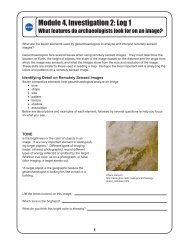
4. Share with students that they will see four images<br />
of disaster pathways. Project transparencies of<br />
Figures 1-4 (or distribute copies) and ask students<br />
to try to identify what they are seeing. Spend time<br />
on the images; talk about possible locations for the<br />
images, any outstanding features in the landscape<br />
that they see, and any other observations that<br />
students want to share.<br />
5. Tell students that they will read letters from imaginary<br />
students in other parts of the world who have<br />
experienced a natural disaster that was shown in<br />
one of the images. Tell students that the imaginary<br />
letter writers would like to have a response from<br />
students in this class.<br />
6. Have the students work in groups and give each<br />
group a page from Log 1 (letter) and a copy of the<br />
image that goes with their letter, and an atlas (or<br />
use a wall map). In a small class, this can be done<br />
with four groups of students, each group with a<br />
different image and letter. A larger class would<br />
require eight groups, with two groups receiving the<br />
same pen pal letter and image. Ask students to<br />
read their letters and to use both the image and<br />
their atlases (or a wall map) to respond to their pen<br />
pal with one letter from the group (or individual<br />
letters from the groups’ members). Encourage<br />
students to be sure that each member of the group<br />
contributes to the project.<br />
Concluding the Activity<br />
7. Bring the class back together and have each group<br />
• read the original pen pal letter,<br />
• show their image,<br />
• trace the pathway on the image and point out<br />
any important features,<br />
• locate the disaster event on the world map,<br />
and<br />
• read the letter or letters they are sending to<br />
their pen pals.<br />
8. Project Figure 3: Hurricane Georges and talk<br />
about possible paths that could be used for evacuation.<br />
Look at the other images and have students<br />
talk about possible ways to escape the disaster. If<br />
students are in a geographic area that experiences<br />
natural disasters, locate regional maps showing<br />
pathways for evacuation purposes.<br />
9. Review how images from space can help people<br />
deal with natural disasters.<br />
Background<br />
Natural hazards are inevitable manifestations of Earth<br />
processes but need not be inevitable disasters. Images<br />
from space can assist society in reducing social<br />
and economic disruptions from future natural disasters<br />
by contributing to the scientific understanding of Earth<br />
processes and conditions that lead to natural disasters.<br />
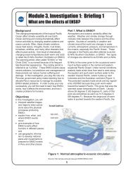
Figure 1: Hawaii In this radar<br />
image, produced by a sensor on the Space Shuttle,<br />
the city of Hilo is seen at the top. Different types of<br />
lava flows around the crater Pu’u O’o are evident.<br />
Ash deposits which erupted in 1790 from the<br />
summit of Kilauea volcano show up as dark in this<br />
image, and fine details associated with lava flows<br />
which erupted in 1919 and 1974 can be seen to the<br />
south of the summit in an area called the Ka’u<br />
Desert. In addition, the other historic lava flows<br />
created in 1881 and 1984 from Mauna Loa volcano<br />
(out of view to the left of this image) can be easily<br />
seen despite the fact that the surrounding area is<br />
covered by forest. This information is used to map<br />
the extent of the lava flows which can pose a<br />
hazard to the subdivisions of Hilo. Highway 11 is<br />
the linear feature running from Hilo to the Kilauea<br />
volcano. The Kilauea volcano has been almost<br />
continuously active for more than 11 years. Field<br />
teams that were on the ground specifically to<br />
support these radar observations report that there<br />
was vigorous surface activity about 400 meters<br />
inland from the coast. A moving lava flow about<br />
200 meters in length was observed at the time of<br />
the shuttle overflight, raising the possibility that<br />
subsequent images will show changes in the<br />
landscape.<br />
2