Section 4 Part 2 - Umgeni Water
Section 4 Part 2 - Umgeni Water
Section 4 Part 2 - Umgeni Water

Create successful ePaper yourself
Turn your PDF publications into a flip-book with our unique Google optimized e-Paper software.
Surface <strong>Water</strong><br />
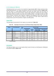
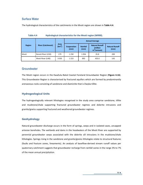
The hydrological characteristics of the catchments in the Mvoti region are shown in Table 4.4.<br />
Table 4.4<br />
Hydrological characteristics for the Mvoti region (WR90).<br />
Annual Average<br />
Region<br />
River (Catchment)<br />
Area<br />
(km 2 )<br />
Evaporation<br />
(mm)<br />
Rainfall<br />
(mm)<br />
Natural Runoff<br />
(million<br />
m 3 /annum)<br />
Natural Runoff<br />
(mm)<br />
Mvoti Nonoti River (U50) 179 1 250 1 056 35.8 200<br />
Mvoti River (U40) 3 035 1 223 892 435.0 143<br />
Groundwater<br />
The Mvoti region occurs in the KwaZulu-Natal Coastal Foreland Groundwater Region (Figure 4.16).<br />
This Groundwater Region is characterised by fractured aquifers which are formed by predominantly<br />
arenaceous rocks consisting of sandstone and diamictite that is Dwyka tillite.<br />
Hydrogeological Units<br />
The hydrogeologically relevant lithologies recognised in the study area comprise sandstone, tillite<br />
and mudstone/shale supporting fractured groundwater regimes and dolerite intrusions and<br />
granite/gneiss supporting fractured and weathered groundwater regimes.<br />
Geohydrology<br />
Natural groundwater discharge occurs in the form of springs, seeps and in isolated cases, uncapped<br />
artesian boreholes. The wetlands and dams in the headwaters of the Mvoti River are supported by<br />
perennial groundwater seeps associated with the dolerite sill intrusions in the mudstone/shale<br />
lithologies. Springs rising in the sandstone and granite/gneiss lithologies relate to structural features<br />
(faults and fracture zones, lineaments). An analysis of baseflow-derived stream runoff values per<br />
quaternary catchment suggests that groundwater recharge from rainfall varies in the range 3% to 7%<br />
of the mean annual precipitation.<br />
93