Deltona Urban Design Master Plan 08/26/2008 - City of Deltona ...
Deltona Urban Design Master Plan 08/26/2008 - City of Deltona ...
Deltona Urban Design Master Plan 08/26/2008 - City of Deltona ...

Create successful ePaper yourself
Turn your PDF publications into a flip-book with our unique Google optimized e-Paper software.
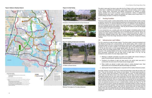
Figure 8: <strong>Deltona</strong>’s Roadway Network<br />
6<br />
Figure 9: On-Site Parking<br />
Intersection <strong>of</strong> Normandy Boulevard and Saxon Boulevard<br />
<strong>Deltona</strong> Boulevard<br />
Figure 10: Existing Infrastructure and Utilities<br />
Lift Station at Graves Avenue<br />
Retention Pond adjacent to Providence Boulevard<br />
<strong>City</strong> <strong>of</strong> <strong>Deltona</strong> <strong>Urban</strong> <strong>Design</strong> <strong>Master</strong> <strong>Plan</strong><br />
The ability to travel easily from place to place within the <strong>City</strong> <strong>of</strong> <strong>Deltona</strong>, and to and from destinations is<br />
a critical factor in establishing and maintaining a good quality <strong>of</strong> life and creating a sense <strong>of</strong> place.<br />
Further roadway studies, improvements and aesthetic enhancements are necessary to maintain<br />
roadway operations and to meet the demand <strong>of</strong> future developments. Section 4.0 Implementation<br />
Strategies provides action steps to address the aesthetics and roadway issues through Section 4.1.2<br />
Cohesive <strong>Design</strong> and Section 4.3 Roads and Transportation.<br />
2.7 Parking Facilities<br />
There are currently no public or private parking facilities in the <strong>City</strong>. Each development, public or private,<br />
is required to meet the <strong>City</strong>’s minimum parking requirements for that particular land use (see Figure 9).<br />
Consequently, there are no perceived deficiencies that need to be addressed. Future developments,<br />
such as the proposed Activity Center located in the southeast quadrant <strong>of</strong> I-4 and Howland Boulevard<br />
will require substantial parking accommodations. There may also be locations for park and ride garages<br />
as part <strong>of</strong> updates to the region’s transit program.<br />
As new developments occur, providing public park and ride garages, consolidating parking lots and<br />
cross-access easements, and limiting parking in front <strong>of</strong> businesses will reduce vehicular travel on the<br />
roadways and create pedestrian-friendly streets that are not dominated by parking lots. Section 4.0<br />
Implementation Strategies provides action steps to address parking facilities through Section 4.1.2<br />
Cohesive <strong>Design</strong> (Private <strong>Urban</strong> <strong>Design</strong> Standards) and Section 4.3 Roads and Transportation (Parking<br />
Facilities).<br />
2.8 Infrastructure and Utilities<br />
The <strong>City</strong> is served by two water and sewer systems. The primary system is owned and operated by the<br />
<strong>City</strong> following its purchase from a private provider, and the second system, which is located in the<br />
northwestern section <strong>of</strong> the <strong>City</strong>, is owned and operated by Volusia County. Water is generally available<br />
throughout the <strong>City</strong>, but sewer is available in only selected areas. Much <strong>of</strong> the residential development<br />
in the <strong>City</strong> was done using an on-site sewage disposal system with about 80% <strong>of</strong> the <strong>City</strong>’s homes<br />
currently using on-site sewage disposal system. The <strong>City</strong>’s comprehensive plan contains a complete<br />
discussion <strong>of</strong> the operating statistics for the water and sewer services and the potential for concern<br />
about groundwater contamination from the large volume <strong>of</strong> septic tanks in the <strong>City</strong>. The key<br />
development issues related to the urban design program include:<br />
• Obtaining an adequate consumptive use permit for the potable water services necessary to<br />
support the planned growth, especially within the Activity Center area<br />
• Providing for the extension <strong>of</strong> water and sewer service to the activity center area which is<br />
currently within the service area <strong>of</strong> the Volusia County managed system<br />
• Where retr<strong>of</strong>its are planned to extend sewer service to existing developed areas, these<br />
improvements can be coordinated with planned street design improvements<br />
• Upsizing water lines and installing sewers in conjunction with the roadway infrastructure projects<br />
Stormwater drainage in the <strong>City</strong> falls into one <strong>of</strong> three land-locked basins named after key lakes in the<br />
basin. These are Lake McGarity, Lake Theresa and Lake Gleason. The natural systems generally do<br />
not have outfalls causing wide fluctuations in lake levels within the basins. The lakes typically have<br />
gentle slopes and wide littoral zones in their natural setting, and the lakes and newer stormwater<br />
management facilities tend to dry out for rather long periods <strong>of</strong> time when rainfall is below normal levels.<br />
The original development plans called for the interconnection <strong>of</strong> the lake systems with the addition <strong>of</strong> a<br />
positive outfall to Lake Monroe. Only one <strong>of</strong> these outfalls was constructed with the initial development.<br />
<strong>Urban</strong> construction was allowed to occur in the flood plain areas <strong>of</strong> the lakes and consequently severe<br />
storms and extended wet periods can result in localized flooding conditions (see Figure 10). The CIP<br />
does not include any funds for renewal and replacement <strong>of</strong> stormwater facilities, but does include over<br />
$13,000,000 in stormwater upgrades. Proper landscaping <strong>of</strong> existing larger ponds should be considered<br />
to create community amenities. However, large scale wet retention ponds within the State Road 472<br />
Activity Center may not be appropriate due to the existing topographic terrain. It may be necessary to<br />
distribute stormwater retention into small facilities with individual developments that will have a smaller<br />
visual impact.