Integrated Assessment Halaco Engineering Company ... - Archives
Integrated Assessment Halaco Engineering Company ... - Archives
Integrated Assessment Halaco Engineering Company ... - Archives

Create successful ePaper yourself
Turn your PDF publications into a flip-book with our unique Google optimized e-Paper software.
<strong>Halaco</strong> <strong>Engineering</strong> Co. IA<br />
CAD009688052<br />
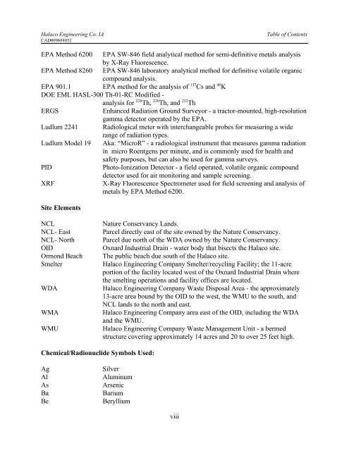
Table of Contents<br />
EPA Method 6200 EPA SW-846 field analytical method for semi-definitive metals analysis<br />
by X-Ray Fluorescence.<br />
EPA Method 8260 EPA SW-846 laboratory analytical method for definitive volatile organic<br />
compound analysis.<br />
EPA 901.1 EPA method for the analysis of 137 Cs and 40 K<br />
DOE EML HASL-300 Th-01-RC Modified -<br />
analysis for 228 Th, 230 Th, and 232 Th<br />
ERGS<br />
Enhanced Radiation Ground Surveyor - a tractor-mounted, high-resolution<br />
gamma detector operated by the EPA.<br />
Ludlum 2241 Radiological meter with interchangeable probes for measuring a wide<br />
range of radiation types.<br />
Ludlum Model 19 Aka: “MicroR” - a radiological instrument that measures gamma radiation<br />
in micro Roentgens per minute, and is commonly used for health and<br />
safety purposes, but can also be used for gamma surveys.<br />
PID<br />
Photo-Ionization Detector - a field operated, volatile organic compound<br />
detector used for air monitoring and sample screening.<br />
XRF<br />
X-Ray Fluorescence Spectrometer used for field screening and analysis of<br />
metals by EPA Method 6200.<br />
Site Elements<br />
NCL<br />
NCL- East<br />
NCL- North<br />
OID<br />
Ormond Beach<br />
Smelter<br />
WDA<br />
WMA<br />
WMU<br />
Nature Conservancy Lands.<br />
Parcel directly east of the site owned by the Nature Conservancy.<br />
Parcel due north of the WDA owned by the Nature Conservancy.<br />
Oxnard Industrial Drain - water body that bisects the <strong>Halaco</strong> site.<br />
The public beach due south of the <strong>Halaco</strong> site.<br />
<strong>Halaco</strong> <strong>Engineering</strong> <strong>Company</strong> Smelter/recycling Facility; the 11-acre<br />
portion of the facility located west of the Oxnard Industrial Drain where<br />
the smelting operations and facility offices are located.<br />
<strong>Halaco</strong> <strong>Engineering</strong> <strong>Company</strong> Waste Disposal Area - the approximately<br />
13-acre area bound by the OID to the west, the WMU to the south, and<br />
NCL lands to the north and east.<br />
<strong>Halaco</strong> <strong>Engineering</strong> <strong>Company</strong> area east of the OID, including the WDA<br />
and the WMU.<br />
<strong>Halaco</strong> <strong>Engineering</strong> <strong>Company</strong> Waste Management Unit - a bermed<br />
structure covering approximately 14 acres and 20 to over 25 feet high.<br />
Chemical/Radionuclide Symbols Used:<br />
Ag<br />
Al<br />
As<br />
Ba<br />
Be<br />
Silver<br />
Aluminum<br />
Arsenic<br />
Barium<br />
Beryllium<br />
viii