reclamation of lands disturbed by mining - Government of British ...
reclamation of lands disturbed by mining - Government of British ...
reclamation of lands disturbed by mining - Government of British ...

Create successful ePaper yourself
Turn your PDF publications into a flip-book with our unique Google optimized e-Paper software.
Province <strong>of</strong> <strong>British</strong> Columbia<br />
Ministry <strong>of</strong> Mines and Petroleum Resources<br />
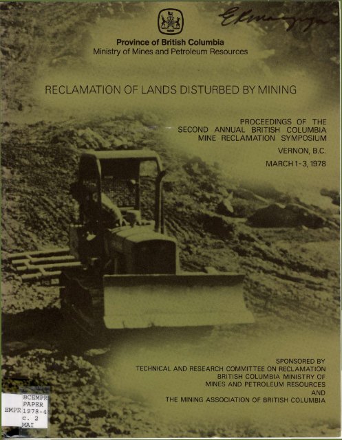
RECLAMATION OF LANDS DISTURBED BY MINING<br />
PROCEEDINGS OF THE<br />
SECOND ANNUAL BRITISH COLUMBIA<br />
MINE RECLAMATION SYMPOSIUM<br />
VERNON, B.C.<br />
MARCH 1-3.1978<br />
BCEMPR<br />
PAPER<br />
SPONSORED BY<br />
TECHNICAL AND RESEARCH COMMITTEE ON RECLAMATION<br />
BRITISH COLUMBIA MINISTRY OF<br />
MINES AND PETROLEUM RESOURCES<br />
AND<br />
THE MINING ASSOCIATION OF BRITISH COLUMBIA<br />
EMPRi978_ 4<br />
c. 2<br />
a
Canadian Cataloguing in Publication Data<br />
<strong>British</strong> Columbia Mine Reclamation Symposium, 2d,<br />
Vernon, B.C., 1978.<br />
Reclamation <strong>of</strong> <strong>lands</strong> <strong>disturbed</strong> <strong>by</strong> <strong>mining</strong>.<br />
Conference held March 1-, 1978.<br />
"Sponsored <strong>by</strong> Technical and Research Committee<br />
on Reclamation, <strong>British</strong> Columbia Ministry <strong>of</strong><br />
Mines and Petroleum Resources and the Mining<br />
Association <strong>of</strong> <strong>British</strong> Columbia."<br />
ISBN 0-7719-8056-6<br />
1. Reclamation <strong>of</strong> land - <strong>British</strong> Columbia -<br />
Congresses. 2. Mineral industries - Environmental<br />
aspects - <strong>British</strong> Columbia - Congresses.<br />
3. Strip <strong>mining</strong> - Environmental aspects -<br />
<strong>British</strong> Columbia - Congresses, II. <strong>British</strong><br />
Columbia. Ministry <strong>of</strong> Mines and Petroleum<br />
Resources. Technical and Research Committee on<br />
Reclamation. II. Mining Association <strong>of</strong><br />
<strong>British</strong> Columbia. III. Title.<br />
S621.5-S8B7 1978 622.31'09711 C78-016004-5
•<br />
0005063677<br />
RECLAMATION OF LANDS DISTURBED BY MINING<br />
PROCEEDINGS<br />
<strong>of</strong> the<br />
SECOND ANNUAL BRITISH<br />
COLUMBIA<br />
MINE RECLAMATION<br />
SYMPOSIUM<br />
Convened at<br />
Vernon<br />
Lodge<br />
Vernon, <strong>British</strong> Columbia<br />
on<br />
March 1, 2, and 3, 1978<br />
Sponsored <strong>by</strong><br />
Technical and Research Committee on Reclamation<br />
<strong>British</strong> Columbia Ministry <strong>of</strong> Mines and Petroleum Resources<br />
and the<br />
Mining Association <strong>of</strong> <strong>British</strong> Columbia
PREFACE<br />
The Ministry <strong>of</strong> Mines and Petroleum Resources is pleased to have<br />
played an active role in sponsoring the Second Annual Mine<br />
Reclamation<br />
Symposium^<br />
This year the program was directed towards attracting a larger<br />
representation from industry. It is gratifying to see how many<br />
participants are in attendance to express the <strong>mining</strong> industry's<br />
point <strong>of</strong> view.<br />
I am certain that greater industry commitment and participation<br />
in a l l aspects <strong>of</strong> <strong>reclamation</strong> w i l l result in the continued<br />
development <strong>of</strong> rational programs <strong>of</strong> environmental protection<br />
and <strong>reclamation</strong> in <strong>British</strong> Columbia.<br />
Honourable Jame^R. J^rabot
TABLE OF CONTENTS<br />
Page No.<br />
EDITOR'S NOTE 9<br />
OPENING REMARKS BY SYMPOSIUM CHAIRMAN -<br />
R.T. Gardiner 11<br />
ANSWERS TO "If you could do one thing to improve <strong>reclamation</strong><br />
in B.C., what would i t be" 15<br />
MINISTRY OF MINES AND PETROLEUM RESOURCES' RECLAMATION<br />
POLICY AND ACTIVITIES<br />
Chairman - E. Macgregor, Associate Deputy Minister, Ministry<br />
<strong>of</strong> Mines and Petroleum Resources 27<br />
AIR PHOTOS AND COAL EXPLORATION PROCEDURE -<br />
D.M. Galbraith, Reclamation Inspector, Ministry<br />
<strong>of</strong> Mines and Petroleum Resources 29<br />
EVALUATION OF CURRENT REVEGETATION TECHNIQUES<br />
IN B.C. - J.C. Errington, Reclamation Inspector<br />
Ministry <strong>of</strong> Mines and Petroleum Resources 51<br />
BRITISH COLUMBIA MINISTRY OF MINES AND PETROLEUM<br />
RESOURCES' RECLAMATION POLICY - J.D. McDonald,<br />
Senior Reclamation Inspector, Ministry <strong>of</strong> Mines<br />
and Petroleum Resources 67<br />
KEYNOTE ADDRESS<br />
Tony Petrina, Vice-President <strong>of</strong> Mining Operations, Placer<br />
Development 81<br />
RECLAMATION PLANNING AS A PART OF MINE PLANNING<br />
Chairman - J.D. Graham, Chief Engineer, Lornex Mining<br />
Corporation 95<br />
FORDING RIVER DIVERSION<br />
J.A. Wood, Vice-President, Kerr Wood Leidal<br />
Associates Ltd 97<br />
RECLAMATION PLANNING AT HAT CREEK, B.C.<br />
F.G. Hathorn, Project Environmental Engineer,<br />
B.C. Hydro and Power Authority and D.K. McQueen,<br />
Soil Scientist, Acres Consulting Ltd 109
TABLE OF CONTENTS<br />
(Continued)<br />
Page<br />
No.<br />
RECLAMATION PLANNING FOR THE LINE CREEK<br />
PROJECT - R.H. Crouse, Vice-President -<br />
Mining, Crows Nest Industries Ltd 133<br />
WORKSHOP SUMMARIES - RECLAMATION POLICY AND<br />
PLANNING 145<br />
SITE PREPARATION - Chairman - R.T. Marshall, Project<br />
Manager, Fording Coal Ltd 157<br />
SITE PREPARATION METHODS EMPLOYED AT<br />
COLEMAN COLLIERIES LTD. - J. Lant,<br />
Reclamation Officer and Forester, Coleman<br />
Collieries Ltd 159<br />
SPOIL DUMP RESLOPING AT FORDING RIVER<br />
OPERATIONS - J. Popowich, Superintendent<br />
Mine Engineering, Fording Coal Ltd 167<br />
WASTE DUMPS - DESIGN, CONTOURING AND VEGETATION<br />
AT KAISER RESOURCES LTD. OPERATIONS<br />
A.W. Milligan, Reclamation Officer and R.J. Berdusco,<br />
Assistant Reclamation Officer, Kaiser Resources<br />
Ltd 185<br />
PRESENTATION OF SECOND ANNUAL RECLAMATION AWARD - Thursday,<br />
March 2, - Evening Banquet 197<br />
RESOURCE PROBLEMS AND SOLUTIONS - Chairman - Dr. J. O'Riordan,<br />
Assistant Director Special Projects, ELUC<br />
Secretariat 205<br />
HABITAT PROTECTION AND ENHANCEMENT FOR WILDLIFE<br />
Dave R. Hurn, Asst. Director Habitat Protection,<br />
Ministry <strong>of</strong> Recreation and Conservation 207<br />
MINING AND ARCHAEOLOGICAL RESOURCES: CONFLICTS<br />
AND MITIGATION PROCEDURES - Bjorn 0. Simonsen,<br />
Provincial Archaeologist, Ministry <strong>of</strong> Recreation<br />
and Conservation 217
TABLE OF CONTENTS<br />
(Continued)<br />
Page No.<br />
RECLAMATION IS MORE THAN KEEPING B.C. GREEN<br />
B.P. Churchill, Biologist, Ministry <strong>of</strong><br />
Recreation and Conservation 225<br />
FEDERAL FISHERIES ACT AMENDMENTS AND THE<br />
MINING INDUSTRY - B.A. Heskin, Manager,<br />
Pollution Abatement Branch, Environmental<br />
Protection Service, Pacific Region and<br />
F.C. Boyd, Chief, Habitat Protection Unit,<br />
Environment Canada 235<br />
WORKSHOP SUMMARIES - RESOURCE PROBLEMS AND<br />
SOLUTIONS 247<br />
RECOMMENDATIONS ON THE FORMAT AND CONTENT OF FUTURE<br />
SYMPOSIA 253<br />
APPENDICES<br />
Appendix A - Poster Show Participants 257<br />
Appendix B - Symposium Program <strong>of</strong> Events... 259<br />
Appendix C - List <strong>of</strong> Symposium Registrants<br />
and Students . . . 263
9<br />
EDITOR'S NOTE<br />
These proceedings present the Symposium events in chronological<br />
order. Presented papers have received minor editing and have<br />
been typed. Time constraints prohibited final text pro<strong>of</strong>reading<br />
<strong>by</strong> individual authors, consequently, the editorial staff accept<br />
responsibility for any<br />
errors.<br />
Question and answer periods were tape recorded. Transcripts<br />
<strong>of</strong> these discussions are given at the end <strong>of</strong> each presented<br />
paper within the proceedings. Severe editing <strong>of</strong> the transcripts<br />
was sometimes necessary to curtail the length <strong>of</strong> the question<br />
and answer dialogue. We apologize for any unwitting alterations<br />
in<br />
meaning.<br />
Comments made during the two round-table workshop sessions have also<br />
been noted and transcribed. Findings which achieved consensus at<br />
the individual tables were read out at the conclusion <strong>of</strong> each<br />
session. There was a considerable variety <strong>of</strong> opinions expressed<br />
and, within the proceedings, an attempt has been made to include<br />
a l l points <strong>of</strong> view. The opinions most <strong>of</strong>ten expressed are listed<br />
f i r s t .
11<br />
OPENING REMARKS<br />
<strong>by</strong> the<br />
SYMPOSIUM CHAIRMAN<br />
R.T.<br />
Gardiner<br />
Chairman<br />
Technical and Research<br />
Committee
12<br />
As the Chairman <strong>of</strong> the Technical and Research Committee I am pleased<br />
to welcome you to this Mine Reclamation Symposium. This is the<br />
second consecutive year our Committee has organized and sponsored<br />
a symposium and I must admit that there was considerable debate<br />
among Committee members concerning the desirability <strong>of</strong> having a<br />
symposium again this year. The reasoning behind the Committee's<br />
decision to convene a second annual symposium may require some<br />
explanation.<br />
The primary purpose for the symposium is to promote communication<br />
and conversation among industry, government, academics, consultants<br />
and other groups or individuals concerned about the impact<br />
<strong>of</strong> <strong>mining</strong> on land and related resources. The Committee felt that<br />
communication<br />
and interchange <strong>of</strong> information are necessary to<br />
improve<br />
our knowledge and understanding <strong>of</strong> the impacts <strong>of</strong> <strong>mining</strong>,<br />
and that discussion among concerned peoples is essential for the<br />
development <strong>of</strong> effective policies, guidelines and technologies<br />
which w i l l minimize any adverse impacts and restore <strong>disturbed</strong><br />
areas to a stable and useful state. The "round table" workshop<br />
sessions, which followed each series <strong>of</strong> lectures during the f i r s t<br />
symposium,will be employed again this year to facilitate these<br />
important<br />
discussions.<br />
There are many inter-related aspects to mined-land <strong>reclamation</strong>,<br />
more than can be adequately discussed within the time limitations<br />
<strong>of</strong> a symposium <strong>of</strong> this type. The Committee felt, therefore, that<br />
i t was possible to organize a program which would be both interesting<br />
and informative without being repetitive. Judging <strong>by</strong> the<br />
large number <strong>of</strong> delegates registered, the Committee has been<br />
successful in choosing topics which are both timely and <strong>of</strong> broad<br />
interest.
13<br />
And finally, i t was considered important to organize a symposium<br />
which would attract a larger representation <strong>of</strong> mine management<br />
personnel than attended the first symposium.<br />
Participation <strong>by</strong> <strong>mining</strong> industry representatives responsible for<br />
formulating and implementing mine <strong>reclamation</strong> policy for the<br />
<strong>mining</strong> companies is essential i f these symposia are to achieve<br />
the purpose for which they are intended.<br />
A highlight <strong>of</strong> the symposium again this year w i l l be the presentation<br />
<strong>of</strong> the Reclamation Award in recognition <strong>of</strong> outstanding<br />
achievement in mined-land <strong>reclamation</strong> and two Citations for merit<br />
in mined-land <strong>reclamation</strong>. We shall be honoured <strong>by</strong> the attendance<br />
<strong>of</strong> the Honourable James Chabot, Minister <strong>of</strong> Mines and Petroleum<br />
Resources, who w i l l present the awards during the banquet on<br />
Thursday<br />
evening.<br />
In conclusion, I would like to take this opportunity to thank the<br />
Committee members, in particular John Errington, symposium convenor,<br />
for their contribution in making this symposium a reality. I would<br />
also like to welcome the large contingent <strong>of</strong> students who are<br />
assisting us again this year in the presentation <strong>of</strong> the symposium.<br />
And last, but <strong>by</strong> no means least, I would like to extend the<br />
appreciation <strong>of</strong> the Committee to those delegates who accepted our<br />
invitations to present papers or to act as session chairpersons.
15<br />
"IF YOU COULD DO ONE THING TO<br />
IMPROVE RECLAMATION IN BRITISH<br />
COLUMBIA, WHAT WOULD IT BE"<br />
The symposium participants were asked to consider the above<br />
fundamental question and provide a written answer on the back <strong>of</strong><br />
the Wednesday night banquet ticket.<br />
The participant's answers, some <strong>of</strong> them meaningful evaluations<br />
<strong>of</strong> the question and others succinctly humorous, are presented<br />
under the classification grouping <strong>of</strong> respondent occupation.<br />
No<br />
attempt has been made to identify individual answer and respondent,<br />
although minor editing has been done to ensure clarity and<br />
good taste, where necessary.
17<br />
ACADEMIC<br />
Increase public awareness <strong>of</strong> the importance <strong>of</strong> <strong>mining</strong> to the economy<br />
<strong>of</strong> <strong>British</strong> Columbia, and ensure that with cooperation and communication<br />
the <strong>mining</strong> industry w i l l carry forth a responsible <strong>reclamation</strong><br />
programme as a part <strong>of</strong> mine planning.<br />
Hire me.'<br />
Do not grant licences until a proper <strong>reclamation</strong> plan has been filed.<br />
Emphasize <strong>reclamation</strong> in the university system to provide new ideas.<br />
Have a l l <strong>reclamation</strong> projects sculptured (in the image <strong>of</strong> Mt. Rushmore,<br />
etc.).<br />
Insist that a l l specs for <strong>reclamation</strong> complete with budget allocation<br />
be submitted prior to any development, plus a commitment on the<br />
part <strong>of</strong> the company that i t w i l l spend that budget on <strong>reclamation</strong>.<br />
Establish a method <strong>of</strong> communication between a l l the different groups<br />
that are working on <strong>reclamation</strong> related problems (i.e., share the<br />
knowledge and research).<br />
Educate the people actually involved in the field on the necessity<br />
<strong>of</strong> preserving the environment as much as possible during the <strong>mining</strong><br />
operation.<br />
Reslope.<br />
Improve the methods <strong>of</strong> disposal and placement <strong>of</strong> spoil piles with<br />
respect to <strong>reclamation</strong>, sloping and revegetation.
18<br />
CONSULTANTS<br />
Increase the number <strong>of</strong> revegetation trials funded <strong>by</strong> <strong>Government</strong> and<br />
industry cooperatively.<br />
Formulate unilateral <strong>reclamation</strong> legislation and create a controlling<br />
body covering a l l resource uses which disturb land. (Not blind<br />
opposition to development - just opposition to blind development).<br />
Provide a "primer" explaining <strong>reclamation</strong> concepts for the "Mining<br />
Industry", "Consultants" and <strong>Government</strong> agencies. Introduce<br />
<strong>reclamation</strong> seminars at <strong>mining</strong> and engineering colleges, etc.<br />
Correlate exploration and core sampling with the <strong>reclamation</strong><br />
programme.<br />
Improve storm water management on a l l mines. No other improvement<br />
would enhance the environment more.<br />
Hire a good<br />
consultant.<br />
Plant more timber trees.<br />
Provide tax incentives to industry for high quality scientific<br />
evaluation <strong>of</strong> their <strong>reclamation</strong> programmes. Evaluations should<br />
include: yield and quality <strong>of</strong> vegetation; species performance;<br />
evaluation <strong>of</strong> fertilization programme; overburden and soil quality.<br />
(Test water quality <strong>of</strong> the stream running through this hotel.')<br />
"Love"<br />
Plant native grass.<br />
Common<br />
sense.<br />
Instil the concept <strong>of</strong> <strong>reclamation</strong> planning as a primary and inseparable<br />
part <strong>of</strong> mine development planning; there<strong>by</strong> avoiding or at<br />
least realizing the problems to be encountered in the final <strong>reclamation</strong><br />
effort. (Prepare an outline <strong>of</strong> general goals and factors influencing<br />
the end results).<br />
Collate, to a central data bank, a l l <strong>reclamation</strong> results (good or bad)<br />
and permit access <strong>by</strong> a l l interested parties.
19<br />
Need some material selection (e.g. rock type, soil type). Material<br />
should be differentiated and assessed to assure maximum success <strong>of</strong><br />
revegetation.<br />
"Hydroseed with<br />
Algenol"<br />
Investigate Federal research on seed and plants for use in <strong>reclamation</strong>.<br />
On good growth media start with agronomic species, then as they die<br />
out introduce native trees, shrubs, and deciduous trees. Finally,<br />
e<br />
introduce the climax species <strong>of</strong> the area. «g., reproduce natural<br />
succession with <strong>reclamation</strong>.<br />
Be reasonable and realistic in terms <strong>of</strong> <strong>reclamation</strong> scale and costs.<br />
Plan earlier to reduce water problems and costs.<br />
To meet the coming <strong>reclamation</strong> need, press for a realistic budget<br />
for the Ministry <strong>of</strong> Mines and Petroleum Resources so that both<br />
internally and through sponsored research, they can provide a<br />
'commercial' supply <strong>of</strong> native seeds (grasses and legumes) for alpine<br />
revegetation.<br />
Use native species for high elevation areas for self-sustaining cover.<br />
Do more trials using native ecotypes.
20<br />
GOVERNMENT<br />
More mines gives more practice (Learn from the experience <strong>of</strong> others).<br />
I would suggest that <strong>reclamation</strong> be laid out and higher bonding be<br />
made mandatory from day one, as far as gravel pits are concerned.<br />
Employ more people in the Ministry to study and administer the<br />
<strong>reclamation</strong> programme in the Province <strong>of</strong> <strong>British</strong> Columbia.<br />
Control Mother<br />
Nature.<br />
Encourage <strong>Government</strong> to take responsibility for abandoned<br />
<strong>reclamation</strong> sites and let industry be responsible for existing<br />
operations.<br />
God, that's a good question.'<br />
Divide the Provincial Inspection Branch into (1) a Mine Safety<br />
Branch, and (2) an Operations Planning Branch. The latter should<br />
be responsible for integrating resource management on land being<br />
used for <strong>mining</strong> purposes. It should also be regionalized to the<br />
same degree that the safety component is currently regionalized<br />
(i.e. need more staff).<br />
Establish strict funding <strong>of</strong> <strong>reclamation</strong> sections <strong>by</strong> <strong>mining</strong> companies<br />
(i.e. a per cent <strong>of</strong> gross income).<br />
Promote the following attitudes: reclaim or maintain (<strong>mining</strong> industry<br />
maximum success or a reasonable alternative (<strong>Government</strong> agencies).<br />
Give the Provincial Mines Reclamation section more staff.'<br />
Incorporate land capability into final design.<br />
Make the <strong>mining</strong> company post a bond or security to cover 50 per cent<br />
<strong>of</strong> the present cost <strong>of</strong> <strong>reclamation</strong> as a requirement to obtain a<br />
<strong>mining</strong> licence.<br />
Train the staff <strong>of</strong> the <strong>mining</strong> companies in the s k i l l <strong>of</strong> <strong>reclamation</strong><br />
(if I knew these s k i l l s ) .<br />
Consider <strong>reclamation</strong> <strong>of</strong> tailings <strong>by</strong> applying topsoil.<br />
Improve tailings disposal methods.<br />
Have your environmentalists work in extractive industry for a while.<br />
Proper mine planning is essential for short-term and long-range<br />
<strong>reclamation</strong>.
21<br />
Discard overburden and tailings into Alberta - they have a slush<br />
fund for this.<br />
Increase the number <strong>of</strong> <strong>reclamation</strong> symposiums.<br />
More <strong>reclamation</strong> pre-planning to control the end result. It is<br />
easier to reclaim with a goal in mind.<br />
Request <strong>reclamation</strong> plans prior to mine opening.<br />
Put more teeth in the Mines Regulation Act to ensure "pre-planning"<br />
and follow through.<br />
Reclamation should be an ongoing process during a <strong>mining</strong> program.<br />
This is particularly applicable to exploratory work where cat roads<br />
are very susceptable to excessive erosion.<br />
Fire a l l the exploration party chiefs who say they w i l l do the cleanup<br />
later.<br />
Improve <strong>mining</strong> management's and engineer's sensitivity with regards<br />
to the beauty <strong>of</strong> nature's <strong>lands</strong>capes and vegetation. In that way,<br />
these people would have increased enthusiasm for <strong>reclamation</strong>, in<br />
the hope <strong>of</strong> emulating nature's beauty.<br />
Achieve a concensus <strong>of</strong> the parties involved in order to speed up and<br />
simplify the <strong>reclamation</strong> review and approval processes.<br />
Utilize domestic sewage sludge to provide organic material and<br />
nutrients for regrowth (i.e. recycle).
22<br />
INDUSTRY<br />
Get a l l people to agree on what <strong>reclamation</strong> really means.<br />
The do-gooders have had their day. The message has been heard. Now<br />
a reasonable approach must be made. The cost to the environment must<br />
be measured against the benefits to the public at large.<br />
Time w i l l cure everything - i t has made the vegetation the way i t is -<br />
i t w i l l cure everything i f given the time. Sun, wind, and time w i l l<br />
definitely do i t again. Meanwhile, the human being can live.<br />
Increase the incentives towards <strong>reclamation</strong> - making i t economically<br />
favourable towards industry. After a l l , industry is economics.<br />
Early planning <strong>of</strong> <strong>reclamation</strong> projects.<br />
Policing the operations <strong>of</strong> the Department <strong>of</strong> Highways (in the northeast<br />
coal areas to be specific).<br />
Bring into political perspective the work <strong>of</strong> nature <strong>of</strong> which man is<br />
only a small part and <strong>mining</strong> an insignificant part.<br />
Continuity <strong>of</strong> <strong>reclamation</strong> (revegetation, recontouring, etc.) in<br />
accordance with exploration and development.<br />
A continuation <strong>of</strong> cooperation between <strong>Government</strong> and Industry along with<br />
more publicity about this cooperation and things done or being done<br />
to the general public.<br />
Relocate Province to Hawaii.<br />
Clean up the Elk valley at Natal there<strong>by</strong> removing an <strong>of</strong>t observed bad<br />
image <strong>of</strong> the coal industry. Action to include relocation <strong>of</strong> people<br />
living on strip, modernization or removal <strong>of</strong> coking plant and<br />
<strong>reclamation</strong> <strong>of</strong> spoil (or refer the problem to Department <strong>of</strong> Highways<br />
and move the scenic route to another valley).<br />
Convince everyone that <strong>reclamation</strong> is a legitimate and desirable part<br />
<strong>of</strong> a <strong>mining</strong> plan and operation.<br />
Incorporate <strong>reclamation</strong> planning at the feasibility stage, provided<br />
that guidelines relative to <strong>reclamation</strong> are clearly spelled out and/<br />
or known at mine planning stage.<br />
Development <strong>of</strong> commercial seed supplies <strong>of</strong> native shrub species.<br />
Legislate that a l l <strong>reclamation</strong> w i l l be done <strong>by</strong> the <strong>Government</strong> out<br />
<strong>of</strong> taxation funds derived from the mines that have to be reclaimed.
23<br />
The emphasis <strong>by</strong> Mr. McDonald on de-regulation rather than over<br />
regulation is a very favorable attitude to continue in industry and<br />
<strong>Government</strong> relations.<br />
Other industries (i.e. forestry) should reclaim their <strong>disturbed</strong><br />
areas to the same degree as <strong>mining</strong> companies. You cannot have two<br />
completely different rules for two different industries that<br />
disturb land in the same areas.<br />
Effectively reduce <strong>mining</strong> taxation, federally and provincially, on<br />
condition that at least 50 per cent <strong>of</strong> the net reduced taxes are<br />
spent on additional improved technical stewardship and implementation<br />
<strong>of</strong> land restoration.<br />
Attend the mine <strong>reclamation</strong> symposium regularly.<br />
Let industry know what the <strong>reclamation</strong> rules are.<br />
Do more research into viable long lasting ground cover.<br />
Take the theoretical approach and apply i t on a practical basis.<br />
Increase cooperation between <strong>Government</strong> and industry in <strong>reclamation</strong><br />
planning.<br />
Develop methods for maintaining vegetation on low phosphorus growth<br />
media.<br />
Reclamation must be practiced, not just preached.<br />
My f i r s t response would be to suggest that logging <strong>reclamation</strong> be<br />
improved considering that logging disturbs vast areas. However, your<br />
question is directed to <strong>mining</strong> I am sure. I would increase the tax<br />
write-<strong>of</strong>f value <strong>of</strong> every dollar spent on <strong>reclamation</strong>.<br />
Reduce Federal, Provincial income taxes and eliminate B.C. sales tax<br />
so that mines operate over a greater l i f e span, there<strong>by</strong> reducing the<br />
<strong>reclamation</strong> dollars/ton extracted.<br />
Quit blaming <strong>mining</strong> for a l l the problems <strong>of</strong> pollution and lack <strong>of</strong><br />
<strong>reclamation</strong>. Much can be done <strong>by</strong> <strong>mining</strong> but costs and benefits must<br />
be balanced. The real (not imagined) damage is minimal.<br />
Land should be reclaimed to a useful state.<br />
Reclamation planning should be advanced into the second or third<br />
stage <strong>of</strong> exploration drilling (i.e. i t should not be left until<br />
the mine feasibility studies have started).<br />
Need to optimize the handling <strong>of</strong> materials. The <strong>reclamation</strong><br />
program must be fully integrated with the mine plan, in cases where<br />
i t is not already being done.
24<br />
Emphasis on the economical utilization <strong>of</strong> proposed sites (i.e. stay<br />
away from "clear cutting" sites and preserve is<strong>lands</strong> <strong>of</strong> natural<br />
growth within an area). This would be <strong>of</strong> significant assistance in<br />
ultimate site restoration especially with gravel borrow pit<br />
operators (e.g. Dept. <strong>of</strong> Highways).<br />
Develop a grass/legume cross which would grow under a l l environmental,<br />
physical and climatic conditions.<br />
Promote a close but not restrictive liaison between industry and<br />
government.<br />
Establish bioregional native species seed collection and a d i s t r i <br />
bution centre.<br />
Re-define the definition <strong>of</strong> <strong>reclamation</strong>.<br />
Change attitudes and expectancies - nature can only be pushed so fast.<br />
Better co-operation between government and industry.<br />
Reinforce Mr. McDonald's pragmatic approach to site specific problems.<br />
Make <strong>reclamation</strong> an integral and automatic part <strong>of</strong> the design, planning<br />
and production functions in a l l mines.<br />
Further educational seminars <strong>of</strong> this nature w i l l increase <strong>reclamation</strong><br />
knowledge and bring about improvement.<br />
Include a course at B.C. I.T., preferably in the evening, dealing<br />
specifically with <strong>reclamation</strong>.<br />
Improve "front line" communication.<br />
Dr. Errington mentioned that topsoil replacement showed good result.<br />
Perhaps more research should be conducted to determine optimum and<br />
minimum depths <strong>of</strong> regolithic material to be replaced over mine spoil<br />
in each climatic zone.<br />
Put stricter regulations on the logging industry and B.C. Ministry <strong>of</strong><br />
Highways. Symposiums such as this one help to provide better communication<br />
between industry, government and consultants.
25<br />
UNCLASSIFIED<br />
Need greater communication between industry and government. Also<br />
should know what the effects <strong>of</strong> not reclaiming are to the environment.<br />
Educate the public to appreciate the environment and learn how to expect<br />
and get more from the <strong>mining</strong> industry in this regard.<br />
Increase the use <strong>of</strong> available technologies through greater increase<br />
in available funds for implementation <strong>of</strong> techniques.<br />
Provide more funds for serious <strong>reclamation</strong> research.<br />
Improve communication between the <strong>mining</strong> companies and other agencies<br />
who are currently gaining experience in <strong>reclamation</strong>, so that a l l<br />
knowledge becomes common knowledge and can be applied wherever<br />
appropriate.<br />
Increase f u l l time job opportunities in the field <strong>of</strong> <strong>reclamation</strong>. From<br />
a practical point <strong>of</strong> view, decreasing government tax levels on mines<br />
may promote availability <strong>of</strong> monies for <strong>reclamation</strong> as required.<br />
Improve upon the acquisition <strong>of</strong> native species for revegetation <strong>of</strong><br />
<strong>disturbed</strong> areas rather than strictly utilizing agriculturally<br />
employed species.<br />
Let "Mother Nature" show the way - and then give her every possible aid.<br />
Explore use <strong>of</strong> native species in replanting and mine <strong>reclamation</strong>.<br />
Investigate the use <strong>of</strong> weathering acceleration agents on bare rock<br />
wastes.<br />
The cost <strong>of</strong> <strong>reclamation</strong> should be <strong>of</strong>fset as a credit against the royalty,<br />
Encourage <strong>reclamation</strong> planning at the earliest possible stages <strong>of</strong><br />
mineral development.<br />
Determine a method <strong>of</strong> removing heavy minerals from run<strong>of</strong>f and<br />
groundwater from a mine tailing (before and after vegetation <strong>reclamation</strong>).
27<br />
MINISTRY OF MINES AND PETROLEUM RESOURCES*<br />
RECLAMATION POLICY AND<br />
ACTIVITIES<br />
Chairman <strong>of</strong> the Afternoon<br />
Session<br />
Wednesday, March 1, 1978<br />
E. Macgregor,<br />
Associate Deputy Minister,<br />
B.C. Ministry<br />
<strong>of</strong> Mines and Petroleum Resources,<br />
Victoria,<br />
B.C.
29<br />
AIRPHOTOS AND COAL EXPLORATION PROCEDURE<br />
Paper<br />
Presented<br />
<strong>by</strong>:<br />
D.M.<br />
Galbraith<br />
Reclamation<br />
Inspector<br />
C. Ministry <strong>of</strong> Mines and Petroleum Resources<br />
Victoria,<br />
B.C.
31<br />
AIR PHOTOS AND<br />
COAL EXPLORATION PROCEDURE<br />
INTRODUCTION<br />
In the last few years, aerial photography has seen increasing use<br />
in the <strong>mining</strong> industry. Air photos have been used in both exploration<br />
and development for planning and documenting work and<br />
access and in making topographic maps. Air photos clearly show top<br />
graphy, vegetation patterns, and ground detail as opposed to the<br />
topographic map which only indicates general topography. As such<br />
the air photo shows considerable promise with respect to environmental<br />
planning and government approvals.<br />
Legislation states that industry shall submit plans <strong>of</strong> work which<br />
protect the environment and that bonding be set to cover the extent<br />
<strong>of</strong> disturbance created. Air photos are the best means <strong>of</strong> documenting<br />
these disturbances as i t is possible to calculate from<br />
them directly the extent <strong>of</strong> a <strong>disturbed</strong> area. Another advantage<br />
with air photos is that other Ministries must be consulted in<br />
the approval <strong>of</strong> an exploration programme, and the air photo base<br />
is a format from which an appreciation <strong>of</strong> an area can be rapidly<br />
obtained.
32<br />
MINISTRY<br />
OF MINES & PETROLEUM RESOURCES AIR PHOTO INVENTORY SYSTEM<br />
The two major coal areas <strong>of</strong> B.C. are the Northeast Coal Block and<br />
the Southeast Coal Block (Figure 1). Both areas are mountainous<br />
with the Northeast having extensive alpine terrain. Coal licences<br />
<strong>of</strong> the Northeast are shown in Figure 2.<br />
The objective <strong>of</strong> the 1977 Northeast project was to produce air photo<br />
mosaics <strong>of</strong> the major coal properties and document the exploration<br />
disturbances to date. The total mosaic coverage is shown in<br />
Figure 3. The photography and mosaics came from a number <strong>of</strong><br />
sources. Black and white photography <strong>of</strong> Carbon Creek and East<br />
Mount Gething was provided <strong>by</strong> Utah Mines Ltd. and the mosaics with<br />
the licence boundaries were prepared <strong>by</strong> T.M. Thompson and<br />
Associates. Black and white mosaics with the licence boundaries<br />
for the Sukunka-Bullmoose, Bullmoose West Fork and Mt. Spieker<br />
properties were provided <strong>by</strong> Teck Corporation. Denison Mines Ltd.<br />
provided color mosaics with licence boundaries for the Quintette<br />
properties.<br />
Completed mosaics showing coal licence boundaries were photographed<br />
and chronaflexes produced that were suitable for making blueprints.<br />
Mosaics were uncontrolled and the boundaries <strong>of</strong> the individual<br />
licences were therefore distorted. Controlled mosaics (orthophotography)<br />
are costly and time consuming and the extra expense was<br />
not justifiable for this project.<br />
Disturbances within the licence areas were interpreted and indexed<br />
on the chronaflex (Figure 4). The area <strong>of</strong> each specific disturbance<br />
was measured using a digitized planimeter and the results were<br />
summarized according to coal licence number (Figure 5).
34<br />
122' 121° FIGURE 2<br />
120 1<br />
PEACE RIVER<br />
COAL PROPERTIES LOCATION MAP<br />
Miles 5 0 5 TO 15 20 Miie%<br />
III I I I I<br />
Kilometres 5 0 10 20 30 Kilometres<br />
N<br />
COAL<br />
LICENCES<br />
UTAH MINES LTD.<br />
CINNABAR PEAK MINES LTD.<br />
BOW RIVER RESOURCES LTD. AND RAINIER ENERGY<br />
RESOURCES INC.<br />
PAN OCEAN OIL LTD.<br />
BRAMEDA RESOURCES LTD.<br />
MASTER EXPLORATIONS LTD.<br />
(NATIONAL TRUST COMPANY LTD J NOW BP COAL<br />
BRAMEDA RESOURCES LTD. AND TECK CORPORATION LTD.<br />
9 (DENWORLD MINING LTD.) NOW QUINTETTE COAL LTD.<br />
10 QUINTETTE COAL LTD.<br />
MclNTRYE MINES LTD. AND CANADIAN SUPERIOR EXPLOR<br />
ATION LTD.<br />
BELCOURT COAL LTD<br />
SAXON COAL LTD.<br />
4<br />
56°-<br />
55°-<br />
ALIENATED COAL RIGHTS<br />
13<br />
120 1
35<br />
122< !21 ( FIGURE 3<br />
120°<br />
PEACH RIVER<br />
COAL PROPERTIES LOCATION MAP<br />
SHOWING MOSAIC COVERAGE ||j|H<br />
Mites 5 0 5 10 15 20 Miles<br />
Kilometres 30 Kilometres<br />
N<br />
COAL<br />
LICENCES<br />
1<br />
2<br />
3<br />
4<br />
S<br />
6<br />
7<br />
8<br />
9<br />
10<br />
11<br />
UTAH MINES LTD.<br />
CINNABAR PEAK MINES LTD.<br />
BOW RIVfiR RESOURCES LTD. AND RAINIER ENERGY<br />
RESOURCES INC<br />
PAN OCEAN OIL LTD.<br />
BRAMEDA RESOURCES LTD.<br />
MASTER EXPLORATIONS LTD.<br />
(NATIONAL TRUST COMPANY LTD.) NOW B.R COAL LTD.<br />
BRAMEDA RESOURCES LTD. AND TECK CORPORATION LTD.<br />
(DENWORLD MINING LTD.) NOW QUINTETTE COAL LTD.<br />
QUINTETTE COAL LTD.<br />
IWclNTRYE MINES LTD. AND CANADIAN SUPERIOR EXPLOR<br />
ATION LTD.<br />
BELCOURT COAL LTD<br />
SAXON COAL LTD.<br />
56°-<br />
55°-<br />
AREAS UNDERLAIN BY<br />
BEARING STRATA<br />
COAL<br />
ALIENATED COAL RIGHTS<br />
COAL<br />
LICENCE<br />
-13<br />
122<br />
1<br />
12V<br />
120'
36<br />
FIGURE 4<br />
SAMPLE PHOTOMAP OF<br />
COAL LICENCE L 326<br />
SCALE: APPROX. 1:10,000<br />
DATE OF PHOTOGRAPHY: SEPT. 1976 DATE OF INVENTORY: APRIL/MAY 1977
37<br />
FIGURE 5<br />
SAMPLE FORM USED TO RECORD EXTENT OF<br />
DISTURBANCE ON EACH COAL LICENCE<br />
COAL LICENCE NO. Lot 326<br />
Photomap based For stereo coverage<br />
u s e<br />
on airphoto McElhannev L4: 95<br />
Photos n r r g <br />
Types and acreages <strong>of</strong> <strong>disturbed</strong><br />
areas<br />
(Mining)<br />
ROADS<br />
Length Width<br />
Sec. m m<br />
Area<br />
m2<br />
DRILL SITES<br />
ADITS<br />
TRENCHES<br />
Area<br />
Area<br />
Area<br />
Sec. m 2 Sec.<br />
m2 „2<br />
Sec.<br />
OTHER<br />
Area<br />
Sec.<br />
1<br />
2<br />
3<br />
4<br />
5<br />
6<br />
7<br />
8<br />
9<br />
10<br />
11<br />
380<br />
1,270<br />
2,120<br />
230<br />
560<br />
840<br />
130<br />
1,360<br />
460<br />
250<br />
150<br />
8<br />
4<br />
8<br />
4<br />
4<br />
5<br />
3<br />
6<br />
11<br />
3<br />
3<br />
2,900<br />
5,010<br />
16,810<br />
920<br />
2,230<br />
4,120<br />
410<br />
8,260<br />
5,470<br />
770<br />
460<br />
1,850 14,730<br />
8,730<br />
Total<br />
46,860 1,850 23,460<br />
Grand<br />
total<br />
72,170<br />
7.2 ha<br />
Disturbances caused <strong>by</strong> other operations<br />
Sec. Area Remarks<br />
m 2
38<br />
The cost <strong>of</strong> the program was $10,800. It was done under contract <strong>by</strong><br />
T.M. Thompson & Associates <strong>of</strong> Victoria. Some <strong>of</strong> the details and<br />
results <strong>of</strong> the program are as follows:<br />
Number <strong>of</strong> licences in the Northeast Coal Block = 721<br />
Number <strong>of</strong> licences reviewed = 212 which included<br />
most <strong>of</strong> the activity.<br />
Number <strong>of</strong> licences with exploration work done = 129 (out <strong>of</strong> 212)<br />
Total disturbance measured = 408.7 ha (There may be another 100 ha<br />
outside the areas surveyed)<br />
Disturbance per worked licence = 3.2 ha average<br />
Non-mine related disturbance = 1.2 ha average per licence<br />
(seismic, forestry)<br />
These figures summarize only disturbances within the actual coal<br />
licences and not those which l i e outside. The areas <strong>of</strong> disturbance<br />
calculated <strong>by</strong> this program were found to be similar to those submitted<br />
<strong>by</strong> the companies.
39<br />
REVISED PROCEDURE FOR DOCUMENTATION OF COAL EXPLORATION<br />
Permit procedure requires that a "Notice <strong>of</strong> Work on a Coal Licence"<br />
must be submitted prior to the actual starting <strong>of</strong> field work, preferably<br />
one month in advance, in any calendar year. As well, a<br />
"Programme for Protection and Reclamation" (to be available in 1978<br />
but presently called "Application for a Reclamation Permit"), must<br />
also be submitted where the employment <strong>of</strong> mechanical equipment is<br />
likely to disturb the surface <strong>of</strong> the land. Currently 12 copies<br />
<strong>of</strong> 1:50,000 topographic maps are requested to accompany these<br />
forms. After the summer <strong>of</strong> 1978, the "Programme for Protection<br />
and Reclamation" w i l l be required to be documented on 2 copies <strong>of</strong> a<br />
1:10,000 air photo base as well as the 12 copies <strong>of</strong> a 1:50,000<br />
topographic<br />
map.<br />
Permit procedure also requires that a "Notice <strong>of</strong> Work on a Coal<br />
Licence" be submitted within one month <strong>of</strong> completion <strong>of</strong> work. A<br />
1:50,000 topographic map documenting the year's activities must<br />
accompany the Notice <strong>of</strong> Work. A "Reclamation Report" which<br />
describes <strong>reclamation</strong> work which has been completed for the calendar<br />
year must be submitted subsequent to cessation <strong>of</strong> exploration<br />
activities. A 1:10,000 air photo base documenting <strong>reclamation</strong><br />
activities must accompany two copies <strong>of</strong> the Reclamation Report.<br />
Formerly, a 1:50,000 topographic map was required.<br />
The above requirements were recently reviewed in conjunction with<br />
the Geology, Titles and Economics sections- <strong>of</strong> the Ministry which<br />
also make requests for information to industry. A common form <strong>of</strong><br />
work reporting is being aimed at which w i l l satisfy the legislative<br />
requirements <strong>of</strong> both the Coal Act and the Coal Mines Regulation Act.<br />
The objective is to have a single submission reporting on work after<br />
i t is completed. The air photo base appears to be the key to<br />
integrating reporting <strong>of</strong> surface work as i t allows for a reduction in the<br />
required text, maps and drawings.
40<br />
The Reclamation Section <strong>of</strong> the B.C. Ministry <strong>of</strong> Mines and Petroleum<br />
Resources is optimistic<br />
that much <strong>of</strong> the currently available air<br />
photo coverage can be utilized <strong>by</strong> operators who are engaged in mine<br />
exploration or production. The Airphoto Services <strong>of</strong> the Ministry<br />
<strong>of</strong> the Environment have extended their co-operation, and both color<br />
and black and white photography <strong>of</strong> twenty mine sites should be<br />
completed <strong>by</strong> the summer and be available <strong>by</strong> late fall, 1978.<br />
Included at the end <strong>of</strong> this paper is an Information Bulletin that<br />
outlines the procedure to be used to select and obtain available<br />
aerial photography.<br />
Further experience with air photos subsequent to the Vernon Symposium<br />
suggests a considerable improvement is possible to the use <strong>of</strong> mosaics.<br />
This involves obtaining original photography at scales <strong>of</strong> 1:25,000<br />
or larger (thus covering several licences simultaneously) and<br />
blowing up to produce prints at a scale <strong>of</strong> 1:10,000. This procedure<br />
has been discussed with several companies in the Northeast Coal<br />
Block, who will use it in 1978 reporting <strong>of</strong> work and <strong>reclamation</strong><br />
done. Results will be discussed at the 1979 symposium.
41<br />
INFORMATION<br />
BULLETIN<br />
GENERAL INFORMATION<br />
The federal and provincial governments are the major sources <strong>of</strong> air<br />
photography in <strong>British</strong> Columbia. General keys to indexes <strong>of</strong> B.C.<br />
photography are available in a publication <strong>by</strong> the Surveys and Mapping<br />
Branch <strong>of</strong> the B.C. Ministry <strong>of</strong> the Environment entitled "Map and<br />
Air<br />
Photo Catalogue".<br />
In cooperation with the National Air Photo Library, Ottawa, micr<strong>of</strong>ilm<br />
<strong>of</strong> federal air photography with the relevant air photo indexes and<br />
catalogues for <strong>British</strong> Columbia, Yukon, and Northwest Territories,<br />
is available for viewing at the Provincial Air Photo Library,<br />
533 Superior Street, Victoria. These indexes are retained on<br />
1:500,000 map scale. Air photographs shown on them can be ordered<br />
from<br />
Ottawa <strong>by</strong> writing to:<br />
National Air Photo<br />
Library,<br />
Dept. <strong>of</strong> Energy, Mines and Resources,<br />
615 Booth Street,<br />
Ottawa, Ontario. KlA 0E9<br />
Tel. (613) 998-9900 - Telex 053-4328<br />
Provincial air photographs are indexed under block photography and<br />
special projects. The bulk <strong>of</strong> photography is contained in the block<br />
system and is available in a number <strong>of</strong> scales. These scales are<br />
1:10000, 1:15840, 1:20000, 1:31680, 1:40000, 1:50000 and 1:63360.<br />
The special projects index is a guide to special air photography<br />
comprising several hundred projects <strong>of</strong> varying scales. Each special<br />
project has an individual<br />
index.<br />
Two types <strong>of</strong> photography are available: colour and black and white.<br />
Most <strong>of</strong> the available photography is black and white. Colour photographs<br />
have been flown only over certain special projects; there is<br />
no general colour photography in <strong>British</strong> Columbia, and i t is not
42<br />
possible to obtain a colour print from a conventional black and white<br />
photograph. Colour is very useful for obtaining ground detail and<br />
vegetation<br />
patterns.<br />
Mosaics can be made from colour or black and white photographs. Colour<br />
mosaics are a one-oi-a-kind production as currently<br />
copies <strong>of</strong> mosaics<br />
can be made only in black and white. A great deal <strong>of</strong> detail and<br />
clarity is lost in duplicating colour mosaics.<br />
Enlargements <strong>of</strong> the standard 23 cm x 23 cm air photograph are available<br />
from the B.C. Provincial Surveys and Mapping Branch. The<br />
largest blow-up for a complete photograph is a 4X enlargement measuring<br />
92 cm x 92 cm.<br />
Portions <strong>of</strong> a standard air photo can be blown up<br />
to 6X enlargements. Air photograph qualities begin to decrease<br />
with<br />
blow-ups 4 times and greater.<br />
Air photo mosaics are available for portions <strong>of</strong> B.C. The Map and<br />
Air Photo Catalogue previously mentioned has a key showing the areas<br />
covered <strong>by</strong> these mosaics. A more detailed key showing the location<br />
<strong>of</strong> available mosaics can be obtained <strong>by</strong> stating the exact geographical<br />
reference <strong>of</strong> your area and writing to:-<br />
Director,<br />
Surveys and Mapping Branch,<br />
Ministry <strong>of</strong> the Environment,<br />
Parliament Buildings,<br />
Victoria, B.C. V8V 1X5<br />
Attention: Map & Air Photo Sales Office<br />
SELECTION OF AIR PHOTOS<br />
The following series <strong>of</strong> steps should be followed to obtain air<br />
photographs:<br />
Sea ).e<br />
Before<br />
ordering any air photos, i t is necessary to determine what<br />
sca^e is best suited to your requirements. Mine exploration and
43<br />
development usually require large scale photography to plan and document<br />
<strong>reclamation</strong> activities. For use in making 1:10,000 mosaics, 1:20,000<br />
photography is best as it only requires 2X enlargement.<br />
Date <strong>of</strong> Photography<br />
The most recent photography is usually desirable.<br />
Flight<br />
Lines and Photo Numbers<br />
Block and special project photography are shown on index maps available<br />
at $1.00 each from the B.C. Provincial Map and Air Photo Sales<br />
Office.<br />
These index maps are also mounted on sets <strong>of</strong> aperture cards. Aperture<br />
card<br />
indexes and readers are available at the following locations:<br />
Map and Air Photo Sales<br />
553 Superior Street,<br />
Victoria, B.C.<br />
Office,<br />
Geological Survey <strong>of</strong> Canada<br />
100 W. Pender Street,<br />
Vancouver, B.C.<br />
V6B 1R8<br />
Simon Fraser University,<br />
Geography Department Library,<br />
Vancouver, B.C.<br />
University <strong>of</strong> <strong>British</strong> Columbia,<br />
Geography Department Library,<br />
Vancouver, B.C.<br />
If one <strong>of</strong> these locations is readily accessible then the following<br />
procedure should be used to find<br />
air photographs:<br />
1. Locate area <strong>of</strong> concern in the appropriate air photo key in the<br />
Map and Air Photograph Catalogue. The choice <strong>of</strong> key depends<br />
upon the scale <strong>of</strong> photography.<br />
2. Determine the geographical reference from the map.<br />
3. Aperture cards are indexed according to scale and geographical<br />
reference. Use the geographical index for the area <strong>of</strong> concern<br />
to select the appropriate aperture card.
44<br />
4. View the card in the reader. Locate exactly the desired<br />
area and record the flight lines and photo numbers that<br />
cover the area. Air photos along a flight line are plotted<br />
with approximately every 10th photo centre numbered. To<br />
determine the photo which covers an area between numbered<br />
centres, it is necessary to interpolate along the line<br />
between those centres.<br />
5. Order air photos following the procedure outlined under<br />
ORDERING AIR PHOTOS.<br />
If these index and reader locations are not readily accessible then<br />
photos may be Obtained<br />
through the Map and Air Photo Sales Office in<br />
Victoria. Phone the <strong>of</strong>fice (Telephone (604) 387-3174 or 3175) and<br />
describe to them where the area is and what type <strong>of</strong> photographs are<br />
desired. They will send <strong>by</strong> mail a photo copy <strong>of</strong> the relevant index<br />
for the scale <strong>of</strong> photography required. Because several indices may<br />
cover an area, to get the correct<br />
index the area must be located<br />
<strong>by</strong> geographic place name or <strong>by</strong> the District Lot numbers within a 15'<br />
latitude/longitude square, based on the National Topographic<br />
Numbering<br />
System.<br />
The necessary flight lines and photo numbers can be read from the<br />
index sent <strong>by</strong> the sales<br />
<strong>of</strong>fice.<br />
ORDERING AIR PHOTOS<br />
Orders for air photos<br />
should be in writing and addressed to:<br />
Director,<br />
Surveys and Mapping Branch,<br />
Ministry <strong>of</strong> the Environment,<br />
Parliament Buildings,<br />
Victoria, B.C. V8V 1X5<br />
Attention: Map and Air Photo Sales Office
45<br />
Appendix I* shows the form to be f i l l e d out when ordering air photos.<br />
The flight numbers and air photo numbers must be included. If<br />
stereoscopic cover is not required, i t is only necessary to order<br />
alternate photos along a flight line. Appendix II l i s t s the prices<br />
on materials. Air photographs are printed to order and have NO<br />
RETURNABLE VALUE. Prepayment is required and 5% sales tax is<br />
applicable for orders within <strong>British</strong> Columbia. Cheques or money<br />
orders should be made payable to the Minister <strong>of</strong> Finance.<br />
Portion enlargements are possible for squares <strong>of</strong>f a photo as listed<br />
in Appendix II. To obtain a partial enlargement, mark the area<br />
required on a xerox copy <strong>of</strong> the air photo, in black, to be sent in<br />
with the order. The marked square must be parallel to the edges <strong>of</strong><br />
the<br />
photograph.<br />
It is also possible to get a blow-up to exact scale, provided the<br />
total blow-up does not exceed 4X. To do this a bar scale on a piece<br />
<strong>of</strong> mylar film <strong>of</strong> two known points on the air photo is needed, with<br />
another bar scale below i t to show the desired final scale <strong>of</strong> these<br />
two<br />
points.<br />
Diapositives <strong>of</strong> photographs are also available. Their main use is in<br />
photogrammetric mapping but they can also be used in overhead projectors<br />
to illustrate on screens, or diazo-printed to provide cheap multiple<br />
copies. For information on diapositives contact the Map and Air Photo<br />
Sales Office in Victoria.<br />
*The Appendices referred to are presented at the end <strong>of</strong> this seminar<br />
paper.
APPENDIX I<br />
ORDER FORM FOR MAPS AND AIR PHOTOGRAPHS<br />
ORDER FORM FOR MAPS AND AIR PHOTOGRAPHS<br />
Your Name Date Your Name Date..<br />
Address<br />
Address<br />
Please send me the following maps and or air photographs<br />
Please send me the following maps and or air photographs<br />
Quantity<br />
Index<br />
No.<br />
Map No./Flight No.<br />
Map Name/Photo Nos.<br />
Unit<br />
Price<br />
Amount<br />
Quantity<br />
lodex<br />
No.<br />
Map No./Flight No.<br />
Map Name/Photo Nos.<br />
Unit<br />
Price<br />
Amount<br />
Add $ 1.00 if maps desired rolled<br />
Add $1.00 if maps desired rolled<br />
For orders delivered in B.C. add 5 per cent sales tax<br />
For orders delivered in B.C. add 5 per cent sales tax<br />
total remittance enclosed<br />
total remittance enclosed<br />
Second Order<br />
Address orders to:<br />
Director, Surveys and Mapping Branch,<br />
<strong>British</strong> Columbia Lands Service,<br />
Victoria, <strong>British</strong> Columbia.<br />
V8V1X5<br />
Attention: Map & Air Photo Sales Office.<br />
Address orders to:<br />
Director, Surveys and Mapping Branch,<br />
<strong>British</strong> Columbia Lands Service,<br />
8 Victoria, <strong>British</strong> Columbia.<br />
J<br />
V8V1X5<br />
Jo First Order Attention: Map & Air Photo Sales Office
47<br />
APPENDIX II<br />
Prices <strong>of</strong> Reprints:<br />
Black and white paper 23 cm X 23cm Price per Print $1.25<br />
Black and white film positive 23cm x 23cm Price per Print $3.00<br />
Colour paper 23cm X 23cm Price per Print $3.00<br />
Prices <strong>of</strong> Enlargements:<br />
Black and white paper 23cm X 23cm Price per Print $3.00<br />
Black and white paper 46cm X 46cm Price per Print $5.00<br />
Black and white paper 68cm X 68cm Price per Print $10.00<br />
Black and white paper 92 cm X 92cm Price per Print $15.00<br />
Black and white film positive 23cm X 23cm Price per Print $5.00<br />
(clear or matte)<br />
Black and white clear or matte 46cm X 46cm Price per Print $10.00<br />
Black and white clear or matte 68cm X 68cm Price per Print $15.00<br />
Black and white clear or matte 92cm X 92cm Price per Print $20.00<br />
Examples <strong>of</strong> Prices <strong>of</strong> Partial Englargements:<br />
Finished<br />
Size<br />
Cost<br />
3X <strong>of</strong> a 7.7 cm square 23cm x 23cm<br />
6X <strong>of</strong> a 7.7 cm square 46cm x 46cm<br />
2X <strong>of</strong> a 11.5 cm square 23cm x 23cm<br />
4X <strong>of</strong> a 11.5 cm square 46cm x 46cm<br />
6X <strong>of</strong> a 11.5 cm square 69cm x 69cm<br />
$3.00<br />
$5.00 *<br />
$3.00<br />
$5.00<br />
$10.00*<br />
* only possible when the centre <strong>of</strong> the photograph falls within the<br />
boundary <strong>of</strong> the marked<br />
square.
48<br />
DISCUSSION RELATED TO D.M. GALBRAITH'S PAPER<br />
Hubert Maxwell - O.K. Syndicate. Do you have an approximate cost <strong>of</strong> the<br />
program born <strong>by</strong> the government <strong>of</strong> B.C., the cost <strong>of</strong> photography and <strong>of</strong><br />
making this information available<br />
ANS. Yes. We have accurate figures for the N. E. Coal Block. It was<br />
done on contract for $10,800.00. For this sum, the photography was<br />
assembled, two mosaics and chron<strong>of</strong>lexes were made, and the <strong>disturbed</strong><br />
area was identified and then measured using an electronic planimeter.<br />
The Ministry <strong>of</strong> the Environment undertakes photographic assignments<br />
for other government departments. In the future, I think that this<br />
photographic capability w i l l see increased use. We are certainly<br />
going to press for i t . Provincial aerial photography already has<br />
a variety <strong>of</strong> uses such as forestry and agriculture, and I think i t<br />
is time we made a case for photographic coverage <strong>by</strong> the provincial<br />
government <strong>of</strong> <strong>mining</strong> and exploration areas.<br />
The cost to us <strong>of</strong> photography, as far as the Ministry is concerned,<br />
is merely the cost <strong>of</strong> the film. To photograph a mine site through<br />
a contracting service the cost may be in the neighbourhood <strong>of</strong> $5,000.00.<br />
It varies with the site. You can't compare the cost for a mine site<br />
that requires one photo to an exploration area that covers 100 square<br />
miles. The cost <strong>of</strong> the film, the prints and everything else is very<br />
minor compared to the cost <strong>of</strong> aircraft and aircrew rental. I can't<br />
foresee many mines paying more than two to three thousand dollars<br />
for a complete flight and print development programme.<br />
The Ministry has a program that includes 20 major operating mines and<br />
this w i l l be made available to industry for use in reporting <strong>reclamation</strong><br />
activity.<br />
At the moment we are feeling our way, but i t appears that i f we are<br />
going to coordinate the reporting <strong>of</strong> work, <strong>reclamation</strong> and other<br />
activities <strong>of</strong> concern to the Ministry, then the airphoto base is the<br />
optimum approach.<br />
James Meier - Byron Creek Collieries. How <strong>of</strong>ten are you going to fly<br />
ANS, We have no plans other than the 20 mine sites that we have requested<br />
so far. If companies are contracting out their own photography, the<br />
frequency <strong>of</strong> flying w i l l depend upon their rate <strong>of</strong> activity. For example,<br />
i f a given coal exploration programme covers 40 licences (40 square<br />
miles), i t may be that the activity is covered in only two square<br />
miles. In this case, the i n i t i a l flying <strong>of</strong> the exploration area for<br />
the base mosaic w i l l be the major cost. Updating <strong>of</strong> photographic data<br />
w i l l thent only require flying over the area where activity has taken<br />
place.
49<br />
For an operating mine, flying every second year would be adequate,<br />
although some fly annually for their own purposes.<br />
Ralph McGinn - O.K. Syndicate. For these 20 mine sites you are going<br />
to fly, w i l l you be establishing survey targets on the ground<br />
ANS. No. For our purposes, an uncontrolled mosaic is suitable. If<br />
you want a geometrically exact mosaic, you have to go to an expensive<br />
process that is called orthophotography where you have to establish<br />
ground control. However, what we are after is a documentation <strong>of</strong><br />
what is on the ground, and whether or not i t is geometrically<br />
accurate, is beside the point. You can get ten uncontrolled<br />
mosaics for the price <strong>of</strong> a controlled one.<br />
Martin Bik - Elco Mining Ltd. Do you have to repeat the flying and<br />
prepare a mosaic annually<br />
ANS. No. Photography every second year in the average case would<br />
be quite adequate for documenting a <strong>reclamation</strong> programme.<br />
Marv Mitchell - Ranger Oil. What degree <strong>of</strong> correlation did you<br />
actually get between the aerial photography and what you found on<br />
the ground when you went in to check<br />
ANS. I don't know because we never checked i t . However, we found<br />
that the <strong>disturbed</strong> areas as submitted, in total, were in the same<br />
"ballpark" as that measured from the maps.
51<br />
EVALUATION OF CURRENT<br />
REVEGETATION TECHNIQUES<br />
USED IN B.C.<br />
Paper<br />
Presented<br />
<strong>by</strong>:<br />
J. C. Errington<br />
Reclamation<br />
Inspector<br />
B.C. Ministry <strong>of</strong> Mines and Petroleum Resources<br />
Victoria,<br />
B.C.
53<br />
EVALUATION OF CURRENT REVEGETATION<br />
TECHNIQUES USED IN B.C.<br />
INTRODUCTION<br />
The Ministry <strong>of</strong> Mines and Petroleum Resources, during the summer <strong>of</strong><br />
1977, began a program to evaluate current revegetation techniques<br />
in several regions <strong>of</strong> <strong>British</strong> Columbia.<br />
The regions, characterized <strong>by</strong> a common climate as well as similar<br />
<strong>mining</strong> operations, were Crowsnest Coalfield, Peace River Coalfield,<br />
and metal mines in the southern interior.<br />
This paper discusses two <strong>of</strong> these regions:- the Peace River coalfield<br />
and the metal mines in the southern interior.
54<br />
REGIONAL ASSESSMENT OF RECLAMATION IN THE PEACE RIVER<br />
COALFIELD<br />
The Peace River coalfield is located in the foothills on the eastern<br />
slopes <strong>of</strong> the Rocky Mountains. There are no active mines in this<br />
area but exploration activity has intensified in recent years and,<br />
should the economics <strong>of</strong> coking coal improve, there is promise <strong>of</strong><br />
several major coal developments proceeding in the near future.<br />
In terms <strong>of</strong> revegetation the climate presents a considerable<br />
challenge. The treeline occurs at elevations <strong>of</strong> 5,000 feet (1,500 m)<br />
in the Peace River coalfield compared to 7,000 feet (2,133 m) in<br />
the<br />
southeast.<br />
The Peace River coalfield lies in a remote wilderness which has<br />
limited access. However, with incursions <strong>by</strong> coal interests, seismic<br />
activity and petroleum drilling as well as forestry industries,<br />
the character <strong>of</strong> the region is rapidly altering.<br />
Most <strong>of</strong> the coal licences f a l l within the Engelmann spruce-subalpine<br />
f i r zone at lower elevations and the Alpine tundra zone at higher<br />
elevations. In terms <strong>of</strong> <strong>reclamation</strong>, areas <strong>of</strong> both Alpine tundra<br />
and the area <strong>of</strong> stunted trees between the alpine and true forest<br />
(termed krummholz vegetation) have similar restrictions to successful<br />
revegetation.<br />
Often the areas are combined and referred to as<br />
"areas<br />
above treeline".
55<br />
FACTORS DETERMINING REVEGETATION<br />
Experience in revegetation <strong>of</strong> disturbances in the Peace River coalfield<br />
has been gained through <strong>reclamation</strong> during exploration programs<br />
and from several field trials set out <strong>by</strong> <strong>mining</strong> companies, their<br />
consultants, and the Ministry <strong>of</strong> Mines and Petroleum<br />
Resources.<br />
The major problems associated with revegetating disturbances caused<br />
<strong>by</strong> exploration occur above the treeline. Here the climate is severe<br />
and plant growth and survival is limited <strong>by</strong> an extremely short<br />
growing season, high wind velocities, and low nutrient levels.<br />
The extreme climatic conditions above the treeline severely restrict<br />
the number <strong>of</strong> species available for use in <strong>reclamation</strong> programs.<br />
Although there are several grass species that perform adequately in<br />
the short term, no legume species have survived longer than one year.<br />
As<br />
sites are generally low in nitrogen and phosphorus, and nutrients<br />
cannot be supplied <strong>by</strong> legume growth, f e r t i l i z e r additions are<br />
necessary for successful revegetation using grass species alone.<br />
In areas below treeline, revegetation <strong>of</strong> exploration disturbance<br />
presents no major problems. Many species <strong>of</strong> grass and legume grow<br />
successfully and are available for <strong>reclamation</strong> programs. Generally,<br />
sites have low nitrogen availability and rely on legume growth for<br />
several years in order to inject enough available nitrogen into the<br />
system to allow grass survival. Low soil moisture on coarse textured<br />
sites, occasionally limits legume growth which affects the growth <strong>of</strong><br />
the entire grass legume mixture. These areas require applications <strong>of</strong><br />
f e r t i l i z e r for successful establishment <strong>of</strong> a grass sward.
56<br />
REVEGETATION PROCEDURES<br />
Three broad types <strong>of</strong> seeding techniques have been tried in the<br />
Peace River coalfield. These are broadcast seeding, harrowing<br />
after broadcast seeding, and hydroseeding.<br />
Broadcast seeding is the most common method used, consisting <strong>of</strong><br />
scattering<br />
seed on the surface <strong>of</strong> the ground.<br />
Broadcast seeding without f e r t i l i z e r applications has resulted in<br />
satisfactory growth at most sites below the treeline. Above treeline,<br />
this method <strong>of</strong> seed application has generally resulted in<br />
poor growth, but this failure may be attributed to lack <strong>of</strong> f e r t i l i z e r<br />
rather than seeding technique. Results <strong>of</strong> pi<strong>of</strong>c trials above treeline<br />
indicate that f e r t i l i z e r applications must accompany seeding for<br />
successful growth and germination, and that, given adequate ferti<br />
l i z e r , most <strong>of</strong> the grass species used in seeding programs w i l l<br />
grow<br />
well.<br />
Harrowing and f e r t i l i z i n g a l l <strong>disturbed</strong> areas above treeline has<br />
been recommended <strong>by</strong> the Ministry <strong>of</strong> Mines and Petroleum Resources since<br />
1976. It is too early to see i f methods involving harrowing have been<br />
successful, however, preliminary observations indicate that seed catch<br />
w i l l be largely improved over former broadcasting techniques.<br />
Hydroseeding<br />
was used in an experimental way in the alpine areas <strong>of</strong><br />
Bullmoose/Chamberlain. I n i t i a l results indicate favourable growth<br />
over the f i r s t summer and good survival is anticipated next year.
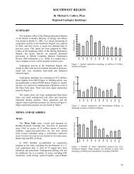
57<br />
ASSESSMENT OF SPECIES PERFORMANCE<br />
In the Peace River Coal Block a total <strong>of</strong> 34 species (or varieties)<br />
consisting <strong>of</strong> 21 grasses and 13 legumes has been seeded at various<br />
times. At the present time i t is not possible to assess the<br />
performance <strong>of</strong> more than half <strong>of</strong> these species with any degree <strong>of</strong><br />
certainty as data on overwintering success is unavailable (Table 1).<br />
Above treeline^ grass species performance was excellent for meadow<br />
foxtail, good for creeping red fescue and timothy, and moderate<br />
for meadow fescue, Canada bluegrass, slender wheatgrass, and<br />
bromegrass. Red top grows well the f i r s t season but has a poor<br />
ability to overwinter. Legume growth was very poor above treeline.<br />
The only two legume species which grew at a l l were<br />
alsike clover and red clover and these grew only in sheltered<br />
moist<br />
pockets.<br />
Below treeline, growth <strong>of</strong> grass and legume species was generally<br />
good for the majority <strong>of</strong> species tested. Growth was excellent for<br />
creeping red fescue and red top; good for Canada bluegrass, slender<br />
wheatgrass, and timothy; and moderate for meadow fescue, bromegrass<br />
and meadow foxtail. Legume growth was excellent for alfalfa, alsike<br />
clover, red clover, sweet clover, and white clover. Birdsfoot<br />
trefoil and sainfoin grew poorly.
58<br />
Table 1<br />
Preliminary evaluation <strong>of</strong> species performance in the Peace River Coal Block, 1977<br />
Above treeline Below treeline<br />
Excel- Un- Excel- Unlent<br />
Good Mod. Poor Dead Known lent Good Mod. Poor Dead Known<br />
Creeping red fescue * *<br />
Meadow fescue * *<br />
Hard fescue * *<br />
Chewing fescue<br />
Kentucky bluegrass<br />
* *<br />
Canada bluegrass *<br />
Perennial ryegrass<br />
*<br />
Annual ryegrass<br />
Tracenta bentgrass *<br />
Colonial bentgrass<br />
*<br />
Crested wheatgrass<br />
Pubescent wheatgrass<br />
* *<br />
Intermediate<br />
wheatgrass * *<br />
Slender wheatgrass * *<br />
Streambank<br />
wheatgrass * *<br />
Bromegrass * *<br />
Orchard grass * *<br />
Red top * *<br />
Reed canary grass * *<br />
Russian wild ryegrass<br />
* *<br />
Timothy * *<br />
Meadow foxtail * *<br />
Alfalfa - beaver * *<br />
Alfalfa - rambler * *<br />
Alfalfa - ceres * *<br />
Alfalfa - drylander * *<br />
Alfalfa * *<br />
Alsike clover * *<br />
Red clover * *<br />
Birdsfoot trefoil * *<br />
Sweet clover * *<br />
White clover * *<br />
Cicer milk vetch * *<br />
Crown vetch * *<br />
Sainfoin * *
59<br />
The Ministry <strong>of</strong> Mines and Petroleum Resources also established plots<br />
to test seeding rates. In the past, the Ministry has recommended<br />
a minimum application rate <strong>of</strong> 50 lb/acre (56 kg/ha) for use in<br />
alpine areas. A rate <strong>of</strong> 25 lb/acre (28 kg/ha) has been recommended<br />
for forested areas. These rates are approximations and, depending<br />
upon a number <strong>of</strong> factors, should be increased and decreased<br />
accordingly.<br />
The forested rate <strong>of</strong> 25 lb/acre does not allow for any harrowing,<br />
therefore seed should not be lost <strong>by</strong> burying too deep. However,<br />
there is l i t t l e margin for the uneven spread <strong>of</strong> seed; consequently,<br />
i f seeding is done without due care and attention, the seeding<br />
rate should be increased to 40 lb/acre (45 kg/ha). The results<br />
<strong>of</strong> these trials should confirm whether these recommendations are val<br />
A second set <strong>of</strong> tests plots was established last f a l l to see i f seed<br />
coated with micronutrients would outperform normal uncoated seed.
60<br />
REGIONAL ASSESSMENT OF RECLAMATION ON METAL MINES IN THE SOUTHERN<br />
INTERIOR OF BRITISH COLUMBIA<br />
INTRODUCTION<br />
Copper <strong>mining</strong> occurs throughout the southern interior <strong>of</strong> <strong>British</strong><br />
Columbia. These mines are generally involved in extraction <strong>of</strong> low<br />
grades <strong>of</strong> copper through open pit operations. A total <strong>of</strong> eight<br />
properties were visited; Bethlehem, Brenda, Craigmont, Lornex,<br />
Newmont, O.K.<br />
Syndicate, Phoenix and Placid Oil.<br />
These mine sites generally occur in dry climates with vegetation<br />
ranging from the Ponderosa pine bunch-grass zone to the interior<br />
Douglas f i r zone to the Engelmann<br />
spruce and subalpine f i r zone.<br />
Precipitation ranges from a low <strong>of</strong> 18 cm/yr. at Craigmont to<br />
around 90 cm/yr. at Phoenix.<br />
Summers are hot and dry.<br />
Last summer's work involved a field assessment <strong>of</strong> the results <strong>of</strong><br />
revegetation<br />
programs.<br />
At the present time, the data have not been analysed in detail<br />
and only preliminary impressions are presented. This discussion<br />
w i l l be limited to waste dump materials; the discussion <strong>of</strong> tailings<br />
w i l l be left until another time.
61<br />
FACTORS DETERMINING REVEGETATION<br />
There are three major factors apparently inhibiting growth on metal<br />
mine wastes: low soil moisture, low soil nutrient levels and steep<br />
unstable<br />
slopes.<br />
Low levels <strong>of</strong> soil moisture are one <strong>of</strong> the major barriers to successful<br />
plant growth. This appears to be a general phenomenon and there have<br />
been a number <strong>of</strong> seeding failures at most mine sites. Many areas that<br />
had growth failures were re-seeded and growth became satisfactory.<br />
In general, once growth has been established i t appears that i t can<br />
be<br />
uaintained.<br />
The data are currently being analyzed to document those conditions<br />
that lessened or hastened drought related failures.<br />
Deficiency symptoms caused <strong>by</strong> low soil nutrient levels contributed<br />
to slow plant growth and establishment at about half the mines visited.<br />
There tends to be a reluctance to add f e r t i l i z e r at the i n i t i a l rates<br />
suggested and then apply maintenance applications as well. Consequently,<br />
many <strong>of</strong> the reclaimed areas are returning to uniform stands <strong>of</strong><br />
creeping red fescue^ and species that are more demanding <strong>of</strong> nutrients<br />
are dying out.<br />
Steep slopes, especially those that lack surface stability, are<br />
also a barrier to plant growth.<br />
The importance <strong>of</strong> waste material type in the ultimate <strong>reclamation</strong> <strong>of</strong> a<br />
mine site should be emphasized. In our surveys, plant growth success<br />
or failure could be <strong>of</strong>ten related to the kind <strong>of</strong> material left on the<br />
surface. Many open pit operations have had to remove considerable<br />
quantities <strong>of</strong> unconsolidated surficial materials which are very
62<br />
<strong>of</strong>ten the best medium for plant growth. This material was frequently<br />
dumped in one location or was lost <strong>by</strong> burial beneath waste rock. Many<br />
<strong>of</strong> the dumps visited had configurations established long before mine<br />
<strong>reclamation</strong> legislation was enacted. For currently operating mines<br />
we recommend that greater attention should be paid to materials<br />
aspects.<br />
Some examples <strong>of</strong> instances where differences in waste material types<br />
have made a significant difference to growth patterns include:<br />
excellent growth <strong>of</strong> coniferous species on the "topsoil" covering <strong>of</strong><br />
waste rock at Phoenix; excellent growth <strong>of</strong> grass and legumes on the<br />
" t i l l " dump at Phoenix and Craigmont; and excellent growth <strong>of</strong> alfalfa<br />
on volcanic waste rock at Craigmont, even on steep slopes. This waste<br />
rock type weathers rapidly and provides a much better growth<br />
medium.
63<br />
REVEGETATION PROCEDURES<br />
In the mines visited there was quite a variety <strong>of</strong> techniques employed<br />
to establish vegetation. Seed has been applied generally <strong>by</strong> broadcast<br />
and hydroseeding.<br />
The merits <strong>of</strong> each method are difficult to<br />
assess as the methods themselves have rarely been tested. There<br />
are as many success stories for each method as there are failures.<br />
No one method should be used exclusively at any mine site.<br />
There should be a maximum degree <strong>of</strong> site preparation before seeding<br />
and, unfortunately, methods <strong>of</strong> seeding have been <strong>of</strong>ten employed<br />
to omit this phase <strong>of</strong> the operation.<br />
For flat surfaces on dumps the compaction should be lessened <strong>by</strong><br />
harrowing. If this is done then any form <strong>of</strong> seeding can be employed<br />
successfully.<br />
Irrigation has been used to establish growth at Newmont and<br />
Craigmont. There was concern expressed a few years ago that this<br />
method was supporting species that would not persist when irrigation<br />
ceased. At Newmont however irrigation <strong>of</strong> several areas stopped<br />
two years ago and plant growth has continued.<br />
ASSESSMENT OF SPECIES PERFORMANCE<br />
A preliminary evaluation <strong>of</strong> species performance on dry mine waste<br />
material has been made (Table 2). The best grass species appear<br />
to be crested wheatgrass and creeping red fescue.<br />
Alfalfa was <strong>by</strong><br />
far the best <strong>of</strong> the legume species. Tall fescue, smooth brome and<br />
timothy a l l grow well under certain conditions. The only wheatgrasses<br />
other than crested wheatgrass to perform adequately were Intermediate<br />
and Pubescent wheatgrass.<br />
Invasion <strong>of</strong> native<br />
species was relatively non-significant.
TABLE 2<br />
PRELIMINARY EVALUATION OF SPECIES PERFORMANCE AT EIGHT METAL MINES IN<br />
THE<br />
SOUTHERN INTERIOR OF BRITISH COLUMBIA,<br />
1977<br />
TYPE OF WASTE<br />
SPECIES<br />
RATING<br />
WASTE ROCK<br />
OVERBURDEN<br />
4J<br />
c
65<br />
DISCUSSION RELATED TO J.C. ERRINGTON'S PAPER<br />
Dave Headdon - University <strong>of</strong> Calgary. You mentioned alfalfa and sainfoin<br />
but not cicer milkvetch. I worry about bloat with alfalfa. Why would<br />
you use alfalfa instead <strong>of</strong> cicer milkvetch for <strong>reclamation</strong> in general<br />
ANS. Cicer milkvetch has been tried but i t hasn't shown to be that<br />
successful. I'm not recommending these particular species. I'm<br />
just saying what has and what has not worked.<br />
Stan Weston - Wesago Consulting. At Craigmont the program was pretty<br />
well cut <strong>of</strong>f about three to four years ago and without the adequate<br />
nutrients you are not going to get growth. Also, with legumes, i t<br />
looks as i f at the start <strong>of</strong> a seeding program you w i l l get certain<br />
species, some <strong>of</strong> which you mentioned. These w i l l degenerate until<br />
you get the desirable deeper rooting permanent ones. It takes about<br />
five years to get the final species. There is also a variation in<br />
growth due to the season as species which are present when you visit<br />
an area may not show at other times. Your presentation is excellent,<br />
but I think that a follow-up should be made on your program and i t<br />
could be subject to some variation.<br />
ANS. We plan to follow up and revisit these areas the year after<br />
next to see what changes have occurred. I agree with your comments<br />
about Craigmont where f e r t i l i z e r had not been applied for a number<br />
<strong>of</strong> years. In fact, that situation occurred at about half the mine<br />
sites. Mining companies are reluctant to keep applying f e r t i l i z e r<br />
for a number <strong>of</strong> years. Nevertheless, Craigmont is a good example<br />
<strong>of</strong> an area that has persisted fairly well for four years without<br />
maintenance fertilizer and to me i t looks quite promising.<br />
Don Graham - Lornex Mining Corporation. I know your group visited<br />
Lornex where we are very much in an experimental stage. We look<br />
forward to seeing the results <strong>of</strong> your work and are a l i t t l e disappointed<br />
that they are not yet available. Perhaps you could t e l l<br />
us when they w i l l be available. We also noticed that i t is definitely<br />
advantageous to plant on glacial t i l l rather than rock. As you<br />
pointed out, the nature <strong>of</strong> the <strong>mining</strong> operation precludes this in a<br />
lot <strong>of</strong> cases. For example, with t i l l on top you take i t <strong>of</strong>f f i r s t<br />
then put i t on the bottom, so that when the rock comes <strong>of</strong>f next i t<br />
is placed on top <strong>of</strong> the t i l l . In many cases with a large operation<br />
considerable distances are involved i f stockpiling material is<br />
considered for later use. Often there are difficulties in finding<br />
sites to stockpile which can represent appreciable increases in<br />
transportation costs.<br />
ANS. A draft <strong>of</strong> the report w i l l be sent to you <strong>by</strong> the end <strong>of</strong> May 1978.<br />
It w i l l not be ready for general circulation in May, but we feel i t<br />
should be sent to the mines we visited for feedback. We are in the
66<br />
process <strong>of</strong> computerizing a l l the data now and i t is that process<br />
which has held us up.<br />
With regards to the waste material types, I appreciate Lornex's problems<br />
handling their material; however, as long as people are familiar<br />
with the response in growth using different materials, that is a<br />
large step in the right direction.<br />
Herman Vaartnou - Vaartnou and Sons. Did you evaluate the<br />
diseases in these plants You mentioned 25 agronomic species,<br />
perhaps you meant varieties.<br />
ANS. No we didn't evaluate the diseases. And yes, I meant varieties.<br />
There w i l l be a l i s t <strong>of</strong> the species tested (Tables 1 and 2) included<br />
in my paper in the symposium proceedings.<br />
Duane Johnson - R. M. Hardy and Associates. Was the aerial seeding<br />
done <strong>by</strong> helicopter or fixed wing Have you compared the relative<br />
success <strong>of</strong> each method<br />
ANS. Aerial seeding was done <strong>by</strong> fixed wing. Success<br />
rates have not been compared.
67<br />
BRITISH COLUMBIA MINISTRY OF<br />
MINES AND PETROLEUM<br />
RESOURCES<br />
RECLAMATION POLICY<br />
Paper<br />
Presented<br />
<strong>by</strong>:<br />
J.D.<br />
McDonald<br />
Senior Reclamation Inspector<br />
B. C. Ministry <strong>of</strong> Mines and Petroleum Resources<br />
Victoria,<br />
B.C.
69<br />
BRITISH COLUMBIA MINISTRY OF MINES<br />
AND<br />
PETROLEUM RESOURCES<br />
RECLAMATION POLICY<br />
INTRODUCTION<br />
Legislation governing mine <strong>reclamation</strong> was introduced in 1969 and is<br />
covered under Section 8, Coal Mines Regulation Act, and Section 11,<br />
Mines Regulation Act. Any land <strong>disturbed</strong> <strong>by</strong> <strong>mining</strong> prior to April 1969<br />
is exempt from the legislation.<br />
Since legislation was introduced, <strong>reclamation</strong> has been dealt with<br />
on a site-specific basis. It is the purpose <strong>of</strong> this presentation to<br />
outline certain guidelines which w i l l be more specific and w i l l allow<br />
industry to deal with those specifics relating to <strong>reclamation</strong> and<br />
abandonment <strong>of</strong> a mine.<br />
Reclamation in <strong>British</strong> Columbia cannot be defined <strong>by</strong> a set <strong>of</strong><br />
regulations or legislation, because <strong>of</strong> the extreme variances <strong>of</strong> physiography,<br />
biogeoclimatic zones and elevations. We have mines in the dry<br />
belt <strong>of</strong> the Okanagan, the rain belt <strong>of</strong> the coast having 240 inches <strong>of</strong><br />
rainfall a year, elevations <strong>of</strong> up to 7,000 feet and in nearly a l l cases,<br />
l i t t l e or no topsoil. It is in this realization that we have dealt<br />
with site specifics with l i t t l e input from industry or government in<br />
the i n i t i a l years. We have now arrived at a point in time where there<br />
is a considerable amount <strong>of</strong> information available, from industry,<br />
government and universities. One <strong>of</strong> the purposes <strong>of</strong> this symposium is<br />
to establish a forum for exchange <strong>of</strong> this information.<br />
One <strong>of</strong> the directives <strong>of</strong> "The Technical & Research Committee on<br />
Reclamation" is to determine where research should be directed <strong>by</strong><br />
industry and government in conjunction with the universities. It is<br />
established that the key areas in <strong>reclamation</strong> research are tailings
70<br />
ponds, waste dumps and drainage. The Ministry <strong>of</strong> Mines and Petroleum<br />
Resources has supported a research program on tailings ponds both<br />
from long-term impact and revegetation techniques.<br />
<strong>British</strong> Columbia <strong>mining</strong> companies have responded to the challenge <strong>of</strong><br />
<strong>reclamation</strong>. Cominco <strong>reclamation</strong> department has conducted an outstanding<br />
research program. Placer Development Ltd. at Salmo and Bull<br />
River Mine <strong>of</strong> Placid Oil Ltd. have both reclaimed mine areas on<br />
completion <strong>of</strong> <strong>mining</strong> to a high degree <strong>of</strong> excellence. During the<br />
past two to three years, Kaiser Resources Ltd. and, lately,<br />
Fording Coal Ltd. have advanced <strong>reclamation</strong> technology in mountainous<br />
areas to a point where they are recognized <strong>by</strong> the coal <strong>mining</strong><br />
industry in North America as leaders in this field <strong>of</strong> <strong>reclamation</strong><br />
in this difficult terrain.<br />
The Ministry <strong>of</strong> Mines and Petroleum Resources has taken the pragmatic<br />
approach to <strong>reclamation</strong> because <strong>of</strong> the many variables associated<br />
with mines in <strong>British</strong> Columbia. This type <strong>of</strong> approach is superior to<br />
specific legislation and regulations which <strong>of</strong>ten cannot be enforced<br />
because they don't f i t the conditions <strong>of</strong> a mine. The presence<br />
<strong>of</strong> so many people from government and industry at this symposium<br />
indicates we are seriously working toward a common goal.<br />
The main emphasis on <strong>reclamation</strong> during the past three years appears<br />
to have been directed towards coal mines. The many proposed coal<br />
projects have necessitated a strong emphasis being placed on coal<br />
mine <strong>reclamation</strong>. Considerable progress has been made in this area.<br />
It is the opinion <strong>of</strong> the Ministry <strong>of</strong> Mines and Petroleum Resources<br />
that metal <strong>mining</strong> companies have not placed the emphasis on <strong>reclamation</strong><br />
to the degree that the coal industry has done.<br />
Mine <strong>reclamation</strong> is an essential part <strong>of</strong> mine planning and i t is<br />
necessary that mine engineering be an integrated part <strong>of</strong> <strong>reclamation</strong>.
71<br />
The largest single cost <strong>of</strong> mine <strong>reclamation</strong> is in site preparation and,<br />
i f this is done at the least cost because <strong>of</strong> good mine planning,<br />
then the total cost <strong>of</strong> <strong>reclamation</strong> is considerably reduced. Engineers,<br />
agrologists and foresters must work as a team.
72<br />
TERMS OF RECLAMATION PERMITS<br />
It has been proposed (and now approved <strong>by</strong> the Minister <strong>of</strong> Mines and<br />
Petroleum Resources) that <strong>reclamation</strong> permits be issued for the l i f e <strong>of</strong><br />
the mine instead <strong>of</strong> the present one-to-three year period. Administration<br />
and control <strong>of</strong> the permit system would be improved. Presently we<br />
have permits which run out <strong>of</strong> their three-year time limit and to renew<br />
requires a process <strong>of</strong> obtaining the recommendation <strong>of</strong> the Advisory<br />
Committee on Reclamation, approval <strong>of</strong> the Minister <strong>of</strong> Mines, and an<br />
Order-in-Counci1. In some cases, this can take two to three months.<br />
In issuing a permit on a permanent basis there would be no loss <strong>of</strong><br />
control <strong>of</strong> any <strong>mining</strong> operation as the present legislation ensures<br />
that the Ministry <strong>of</strong> Mines and Petroleum Resources can enforce<br />
strong penalties on an operation i f the terms and conditions are not<br />
complied with. Control <strong>of</strong> <strong>reclamation</strong> activities and additional<br />
development which disturbs land is reviewed on a yearly basis. Annual<br />
reports are submitted each year. The reports include a breakdown<br />
<strong>of</strong> <strong>disturbed</strong> land, future <strong>disturbed</strong> land, present and future <strong>reclamation</strong><br />
activities, <strong>reclamation</strong> research and other related fields. With an<br />
increase in staff in the Reclamation Section <strong>of</strong> the Ministry <strong>of</strong> Mines<br />
and Petroleum Resources, an improvement in on-site inspection has<br />
been possible. Increases in the security deposit can be recommended<br />
on the basis <strong>of</strong> the annual report. Performance and increase in <strong>disturbed</strong><br />
areas would be considered.
73<br />
EXPLORATION GUIDELINES<br />
For metal and coal exploration the Ministry <strong>of</strong> Mines and Petroleum<br />
Resources has issued "Guidelines for Coal and Mineral Exploration"<br />
which governs <strong>reclamation</strong> and protection <strong>of</strong> the environment. The<br />
only recent addition to these guidelines is that companies must now<br />
reclaim within one year <strong>of</strong> the disturbance a l l exploration areas<br />
except those areas that w i l l be used during exploration the following<br />
year.<br />
GUIDELINES FOR MINE RECLAMATION<br />
The guidelines that follow are preliminary. I would like to have<br />
input from industry and government agencies before they are finalized<br />
and your representations at this meeting or in the immediate future<br />
would be<br />
appreciated.<br />
MINE ABANDONMENT<br />
(A) When a mine is shutdown and the entire plant is left on the<br />
property i t shall be considered a temporary shutdown. Reclamation <strong>of</strong><br />
the <strong>disturbed</strong> areas shall be done on the basis determined <strong>by</strong> the<br />
Reclamation Section <strong>of</strong> the Ministry <strong>of</strong> Mines and Petroleum Resources.<br />
(B) Where a mine is shutdown and the mine plant removed the following<br />
shall be done:<br />
General<br />
(1) The <strong>mining</strong> company shall submit to the Senior Reclamation Inspector<br />
a plan <strong>of</strong> total <strong>reclamation</strong> prior to shutdown.<br />
(2) A l l buildings, machinery, mobile equipment shall be removed.<br />
A l l scrap material shall be burned or buried. Open holes shall<br />
be f i l l e d in and revegetated.
74<br />
(3) Concrete foundations and slabs shall be left intact and covered<br />
<strong>by</strong> overburden and revegetated where<br />
possible.<br />
(4) All provisions <strong>of</strong> either the Mines Regulation Act or Coal Mines<br />
Regulation Act shall be complied with to the satisfaction<br />
<strong>of</strong> the<br />
District Inspector or Resident Engineer.<br />
Tailings ponds<br />
(1) A plan shall be submitted showing the proposed drainage<br />
controls for the tailings pond and surrounding<br />
drainage<br />
area.<br />
(2) Where necessary a permanent spillway is required on or<br />
adjacent to the tailings dam to provide for excessive<br />
run-<strong>of</strong>f <strong>of</strong> water. Details and design shall be submitted to<br />
the Chief Inspector <strong>of</strong> Mines and Petroleum<br />
Resources and the<br />
District<br />
Inspector for approval.<br />
(3) The tailings pond shall be contoured where necessary to<br />
control run-<strong>of</strong>f.<br />
(4) The tailings pond shall be revegetated to a condition<br />
approved <strong>by</strong> the Reclamation<br />
Section <strong>of</strong> the Ministry <strong>of</strong><br />
Mines and Petroleum. Resources.<br />
Vegetation must be established<br />
to a point where no maintenance <strong>of</strong> the vegetation<br />
is<br />
required and there is no dangerous accumulation <strong>of</strong> toxic<br />
constituents.<br />
A minimum <strong>of</strong> three years experience is<br />
necessary to determine the quality <strong>of</strong> vegetation.<br />
(5) Ultimate land use <strong>of</strong> the <strong>disturbed</strong> areas shall be specified.<br />
The reclaimed land shall be equal to or better than the<br />
original<br />
area which was <strong>disturbed</strong>.<br />
Waste Dumps - Metal<br />
(1) Where possible waste dumps should be sloped to an angle where<br />
vegetation can be maintained.<br />
If overburden is available,
75<br />
flat areas <strong>of</strong> the dumps shall be covered to a depth <strong>of</strong><br />
three to six inches <strong>of</strong> overburden or top<br />
soil.<br />
(2) A l l flat areas on the dumps shall be revegetated and<br />
vegetation<br />
shall be established to a point where no<br />
maintenance is required. A minimum <strong>of</strong> three years experience<br />
is necessary to determine the quality <strong>of</strong> vegetation.<br />
(3) A plan <strong>of</strong> the drainage area surrounding the dumps shall be<br />
submitted to the Senior Reclamation Inspector. Where<br />
possible a l l drainage should be directed away from the dumps.<br />
(4) Ultimate land use <strong>of</strong> the <strong>disturbed</strong> dump area shall be<br />
specified.<br />
Waste Dumps -<br />
Coal<br />
(1) Final slope <strong>of</strong> coal waste dumps shall be 26 degrees or at<br />
an angle where the dump is physically stable and vegetation<br />
can be maintained<br />
on the slope <strong>of</strong> the dumps.<br />
(2) A l l coal waste dumps shall be revegetated to a point where<br />
vegetation is free <strong>of</strong> maintenance.<br />
(3) A plan <strong>of</strong> the drainage area surrounding the dump area shall<br />
be submitted to the Senior Reclamation Inspector. Where<br />
possible a l l drainage should be directed away from the dumps.<br />
(4) Ultimate land use <strong>of</strong> the reclaimed dumps shall be specified.<br />
(5) A minimum <strong>of</strong> three years is necessary to determine the<br />
quality<br />
and the permanence <strong>of</strong> the established vegetation.<br />
Pit<br />
Area<br />
(1) Pits shall be backfilled whenever possible.<br />
(2) A plan shall be submitted to the Senior Reclamation Inspector<br />
showing how the pit area shall be left after completion <strong>of</strong><br />
<strong>mining</strong>.
76<br />
Where the pit area is going to be designated as a lake, a<br />
report shall be submitted to the Senior Reclamation Inspector<br />
outlining source <strong>of</strong> water, drainage area, maximum level<br />
<strong>of</strong> water, water quality, access to lake, plans for stocking<br />
<strong>of</strong> the lake.<br />
Where the pit floor w i l l be free from water, where possible<br />
overburden shall be used to provide sufficient cover to<br />
establish<br />
vegetation.<br />
Pit walls shall be left in a safe manner to the satisfaction<br />
<strong>of</strong> the District Inspector <strong>of</strong> Mines.
77<br />
DISCUSSION RELATED TO J.D. MCDONALD'S PAPER<br />
Hubert Maxwell - O.K. Syndicate. How do we go about evaluating the<br />
cost <strong>of</strong> <strong>reclamation</strong> over an undetermined period until the <strong>reclamation</strong><br />
w i l l support itself<br />
ANS. You evaluate the cost through the <strong>mining</strong> plan. You must<br />
consider where you place the waste material. If you place the<br />
material properly, you don't have to come back to recontour the<br />
whole dump before covering with stockpiled topsoil. Consideration<br />
must be given as to what type <strong>of</strong> materials are available for<br />
surface dressing the top <strong>of</strong> the dump. For example, Afton did a<br />
survey which showed that the f i r s t 10 feet <strong>of</strong> t i l l and overburden<br />
should be buried because i t has a very high pH and a high salt<br />
content. So, in their case they couldn't stockpile. This shows<br />
the value in following planning procedures such as soil testing.<br />
The cost can vary anywhere from $500/acre up to $10,000/acre.<br />
The coal companies are looking at a cost in the neighbourhood <strong>of</strong><br />
$5000/acre. In other areas where there is lower relief, i t w i l l<br />
be considerably less.<br />
Hubert Maxwell - O.K. Syndicate. In the project evaluation you<br />
can go the high road and do the impact studies and the whole bit<br />
and i f you are looking at $125,000 a mile for a power line, that's<br />
a figure. These are things which must be determined whether you<br />
have a project or not. My impression is that you have to look<br />
after <strong>reclamation</strong> to eternity. I know some places where there<br />
were steep sided waste dumps which have been there for 30 years and<br />
now i t is hard to find them. Over a period <strong>of</strong> time they w i l l<br />
restore themselves to some effect. And now you are talking about<br />
posting bonds before you start production to look after <strong>reclamation</strong><br />
for X number <strong>of</strong> years, and that's an unknown quantity.<br />
ANS. Well, I'm not talking about anything new. This has already<br />
been done. We have examples in the province today where companies<br />
have posted bonds, done their <strong>reclamation</strong> and closed down. Some<br />
<strong>of</strong> them have done a very fine job.<br />
Hubert Maxwell - O.K. Syndicate. I realize that and I'm not against<br />
<strong>reclamation</strong>, I'm a l l for i t . In my particular endeavour we are<br />
looking at bringing an old mine into production. I don't have enough<br />
money left in my operations after paying 57% in taxes to look after<br />
<strong>reclamation</strong> after cessation <strong>of</strong> operations for an undetermined period<br />
until the vegetation becomes self sustaining.<br />
Are we reaching a point in our evaluation where we should have an<br />
impact study f i r s t before we go out looking for minerals
78<br />
ANS, Well, this is almost the way coal mines do i t in B.C. today. In<br />
their feasibility studies they look at what has to be done to meet<br />
the requirements. My proposals set forth a pragmatic approach<br />
which has been gained from experience and used in the past. We like<br />
to maintain our approach as a set <strong>of</strong> guidelines so we have room to<br />
maneuver and deal with things on a site-specific basis.<br />
Afton Mines, for example, has done an impact study and we feel that<br />
they have come up with a good scheme. They have taken <strong>reclamation</strong><br />
into consideration in their <strong>mining</strong> plan and have stored material -<br />
some topsoil and some overburden - for future use. They are also<br />
in the cattle ranching business. Their proposed dump and tailings<br />
sites comprise a large area which could be reclaimed and used for<br />
grazing purposes. Also with some irrigation they could establish<br />
very good hay crops. What I am trying to say is that a l i t t l e<br />
i n i t i a l planning can go a long way and save a lot <strong>of</strong> money later on.<br />
Pat Mahoney - Montreal Engineering Co. Ltd. Who decides what the<br />
land use should be<br />
ANS, The land use depends upon where the mine is located. If i t<br />
is in a forest area then i t should be re-established as a forest<br />
area. The same applies i f i t is in wildlife habitat. We haven't<br />
really dealt with agriculture here in B.C. because very l i t t l e<br />
<strong>of</strong> our <strong>mining</strong> is done in agricultural areas. Most <strong>of</strong> our <strong>mining</strong><br />
is done on mountain tops where there is very l i t t l e vegetation.<br />
Where we can improve the previous use <strong>of</strong> land, we do. For example,<br />
i t has been demonstrated in the East Kootenay that reclaimed areas<br />
are more productive as wildlife habitat than they were previous<br />
to <strong>mining</strong>.<br />
Pat Mahoney - Montreal Engineering Co. Ltd. You are saying that<br />
better is an improved version<br />
ANS, Yes, when compared to what was there before. We don't necessarily<br />
return to previous use especially i f i t can be put to a better use.<br />
Alberta has different problems in their particular areas, because<br />
they have a lot <strong>of</strong> agricultural land and i t is essential that they<br />
return the land to as good or better state than before they strip<br />
mine i t . They are dealing with a set <strong>of</strong> specifics that we have<br />
not encountered yet in B.C.<br />
Pat Mahoney - Montreal Engineering Co. Ltd. If a company decides on<br />
an alternative land use, who evaluates and decides the merit <strong>of</strong> the<br />
alternative proposal<br />
ANS, I had better be specific about this. In coal <strong>mining</strong> there is a<br />
set <strong>of</strong> guidelines for coal development in B.C. which is under the<br />
authority <strong>of</strong> the Environmental Land Use Committee. These guide-
79<br />
lines outline the process that you go through for a coal development.<br />
It is in the Stage I and Stage II reports where land use after<br />
<strong>mining</strong> is proposed. The Coal Development Steering Committee<br />
examines these reports and sends copies to a l l concerned agencies<br />
for comments. If you propose a better land use then I'm sure<br />
the committee w i l l go along with i t .<br />
In metal <strong>mining</strong>, the decision on land use is basically up to the<br />
Reclamation Section <strong>of</strong> the Ministry <strong>of</strong> Mines and Petroleum Resources<br />
who receive input from other agencies through the Reclamation<br />
Advisory Committee.<br />
J. Johnson - Craigmont Mines Ltd. Will your guidelines be published<br />
shortly<br />
ANS. Yes. They should be issued in six weeks to two months<br />
providing industry doesn't object strongly.
81<br />
KEYNOTE ADDRESS<br />
<strong>of</strong> the<br />
SECOND ANNUAL<br />
MINE RECLAMATION<br />
SYMPOSIUM<br />
March 1, 1978<br />
Given <strong>by</strong>:<br />
Mr. Tony Petrina<br />
Vice-President <strong>of</strong> Mining<br />
Operations<br />
Placer<br />
Development<br />
Vancouver, B.C.
83<br />
Mr. Chairman, Ladies and Gentleman, and Learned Experts in the field<br />
<strong>of</strong> <strong>reclamation</strong>, I must admit to not being an expert on <strong>reclamation</strong>.<br />
In fact, <strong>of</strong> a l l the people in this room, I am undoubtedly one <strong>of</strong> the<br />
least knowledgeable on <strong>reclamation</strong>. A l l <strong>of</strong> which naturally raises<br />
the question, why am I, instead <strong>of</strong> any <strong>of</strong> the formidable number <strong>of</strong><br />
authorities on <strong>reclamation</strong>, speaking to this group tonight The<br />
answer is really quite simple. About ten days ago, while I was in<br />
Toronto, my good friend, Jake McDonald, phoned my boss, looking for<br />
a speaker. My boss, long renowned for his magnanimity in such<br />
matters, very kindly volunteered my services in absentia.<br />
Nevertheless, in spite <strong>of</strong> my lack <strong>of</strong> expertise, I want i t clearly<br />
understood that I am in favour <strong>of</strong> <strong>reclamation</strong>--whatever that means.<br />
I am also in favour <strong>of</strong> motherhood, nuclear disarmament, peace in<br />
our time, and numerous other issues.<br />
My problems in preparing a speech for you were, f i r s t , my lack <strong>of</strong><br />
knowledge <strong>of</strong> the subject, and second, the lack <strong>of</strong> time for preparation.<br />
After going through a pile <strong>of</strong> technical papers about two<br />
feet high on the weekend, I asked myself what can I possibly t e l l<br />
these experts that they don't already know, or has not already been<br />
said "Ad Infinitum"<br />
While I was trying to outline this talk on Sunday, my wife asked me<br />
what "Reclamation" meant — and you know, I really couldn't give<br />
her a straightforward answer. So I thought this is at least a<br />
good start for a speech — I w i l l define "Reclamation" for the<br />
experts! Easier said than done.'<br />
After pouring over the technical literature for m$ny hours, I<br />
didn't come up with a definition to end a l l definitions -- but<br />
I sure learned some good buzz-words. How about:<br />
Biogeoclimatic<br />
Ungulate
84<br />
Early Serai<br />
Bayonet Blade Technique<br />
Limnological.<br />
In desperation, I finally turned to my trusty Oxford Universal<br />
Dictionary, which gives several definitions for <strong>reclamation</strong>:<br />
"The action <strong>of</strong> protesting" - Well, that seems to f i t , as far as i t<br />
goes.<br />
"The action <strong>of</strong> calling or bringing back from wrongdoing - The action<br />
<strong>of</strong> reclaiming from barbarism." Unfortunately, there are too many<br />
people who would accept that definition.<br />
"The making <strong>of</strong> land f i t for cultivation" - That might f i t somewhere,<br />
but certainly not in Northern B.C. or the Yukon, where very l i t t l e<br />
<strong>of</strong> the land occupied <strong>by</strong> mines was f i t for cultivation in the f i r s t<br />
place.<br />
None <strong>of</strong> these definitions really seemed to describe <strong>reclamation</strong> as<br />
i t applies to mines in <strong>British</strong> Columbia; clearly, I had to seek the<br />
answer elsewhere. I would ask people who were involved in <strong>reclamation</strong><br />
in<br />
some way or other.<br />
I ASKED THE MANAGER OF A MINE: He said, "Reclamation is when I<br />
spend $500 an acre to turn land that was originally worth $25<br />
an acre into land that w i l l be worth $25 an acre."<br />
I ASKED A GOVERNMENT M.L»A; He said, "Reclamation — That's<br />
how you s e l l B.C. Hydro bonds."<br />
I ASKED A TRADE UNION OFFICIAL: He said, "Reclamation is something<br />
the company should spend a lot more money on — unless they're<br />
willing<br />
to pay higher wages!"<br />
I ASKED A RESIDENT OF A SMALL REMOTE NORTHERN MINING COMMUNITY: He<br />
said, "Reclamation — That's what the mine does to keep the tourists<br />
from the Lower Mainland from complaining."<br />
I ASKED AN AGRONOMIST Who occasionally does consulting work for<br />
<strong>mining</strong> companies: He said, "Reclamation: That's how you make<br />
$500 a day selling grass seed."
85<br />
Obviously, <strong>reclamation</strong> means different things to different people.<br />
It reminds me <strong>of</strong> that familiar old expression —"Reclamation is<br />
in the eye <strong>of</strong> the beholder."<br />
Anyway, since I have failed to define i t for you, let me at least<br />
make some observations on various attitudes towards <strong>reclamation</strong>,<br />
and indeed towards <strong>mining</strong> itself.<br />
A few years ago, not long after the <strong>reclamation</strong> amendments were<br />
added to the Mines Regulation Act, I was operating a mine in the<br />
Southern Interior, and we had recently gone to some trouble and<br />
expense to get a pretty fair growth <strong>of</strong> Alfalfa on the downstream<br />
slope <strong>of</strong> our tailing dam. I was rather proud <strong>of</strong> this feat (although<br />
my own contribution was negligible) because in my<br />
opinion, we had<br />
actually improved upon the original land. The neighbouring rancher<br />
liked i t too, because he was continually cutting our fence to let<br />
his cattle graze on i t . At any rate, a young man employed <strong>by</strong> the<br />
Department <strong>of</strong> Mines dropped in one day to see this biological marvel,<br />
and I personally escorted him through the waist high verdure,<br />
taking care to avoid the numerous cow-flaps. Bursting with pride<br />
I said, "Well, what do you think about that" He replied in a<br />
deprecatory manner, "Well — It's O.K. — as far as i t goes. I<br />
mean, it's green a l l right, but it's only cosmetic <strong>reclamation</strong>."<br />
Completely shattered, I asked what that meant. If I understood<br />
correctly, his view was that the land should be returned as nearly<br />
as possible to its original state — not improved upon.'<br />
A constant source <strong>of</strong> amazement to me is the difference in attitudes<br />
held <strong>by</strong> many people concerning land alienated <strong>by</strong>.Highways, and land<br />
used <strong>by</strong> Mining. In Canada there is about two hundred times as much<br />
land occupied <strong>by</strong> Highways, in perpetuity, as is temporarily occupied<br />
<strong>by</strong> mines. Not much <strong>mining</strong> is done on arable land; much <strong>of</strong> our
86<br />
Highways System, especially in B.C., is on prime agricultural land.<br />
The <strong>Government</strong> seeks accolades for its plan to alienate forever,<br />
thousands <strong>of</strong> acres in the construction <strong>of</strong> the Coquihalla Highway.<br />
Another way <strong>of</strong> looking at i t is that a postage stamp on the floor<br />
<strong>of</strong> a large living room would represent the proportion <strong>of</strong> Canada<br />
occupied <strong>by</strong> <strong>mining</strong>; in B.C. there is probably not more than 80<br />
square miles <strong>disturbed</strong> <strong>by</strong> <strong>mining</strong>. For those who claim that <strong>mining</strong><br />
has a significant impact on wildlife because <strong>of</strong> its removal <strong>of</strong><br />
wildlife habitat, compared to other forms <strong>of</strong> land use, I say that<br />
you are stretching your credibility well beyond the breaking point.<br />
I read recently about a <strong>mining</strong> operation being built on remote<br />
mountainous terrain in the United States, the power lines to the<br />
mine were installed in a zig-zag pattern to hide them from view;<br />
u t i l i t y poles were painted green to match the scenery in this remote<br />
area; horses rather than bulldozers were used where trees had to<br />
be felled. Naturally, these activities added to the cost <strong>of</strong> the<br />
venture and were borne <strong>by</strong> the <strong>mining</strong> company. When I read this,<br />
I thought <strong>of</strong> the great hydro transmission lines so artfully<br />
concealed from view in the Fraser Canyon.<br />
In 1972, just prior to that Provincial election in which the<br />
electorate <strong>of</strong> B.C. decided to sample for a time the hitherto<br />
forbidden fruits <strong>of</strong> Socialism, I had the interesting experience <strong>of</strong><br />
attending in Kamloops, a public hearing at which a consortium <strong>of</strong><br />
three <strong>mining</strong> companies presented, and defended, a proposal to erect<br />
a copper smelter at Clinton, B.C. The only people who spoke in<br />
favour <strong>of</strong> the proposal were the spokesman for the <strong>mining</strong> companies<br />
and some residents <strong>of</strong> Clinton. The people who spoke against i t ,<br />
and there were many, were mainly residents <strong>of</strong> the Lower Mainland;<br />
they spoke passionately and with conviction against the construction<br />
<strong>of</strong> a smelter in Clinton or anywhere else in B.C.<br />
Was their eloquence prompted <strong>by</strong> concern for the people <strong>of</strong> Clinton,<br />
or <strong>by</strong> a desire to keep the interior <strong>of</strong> the Province a perpetual
87<br />
Psfrkland for the occasional use <strong>of</strong> the city - dwellers from the South<br />
The application for the construction <strong>of</strong> the smelter was never acknowledged<br />
<strong>by</strong> the newly elected <strong>Government</strong>, and <strong>of</strong> course i t was<br />
not built. I don't really know whether the people <strong>of</strong> B.C. wanted<br />
a smelter at that time, or not, but certainly the very vocal, very<br />
articulate group <strong>of</strong> Vancouverites parachuted into that hearing did<br />
not want one.<br />
In pursuing my career in the B.C. <strong>mining</strong> industry over the last 18<br />
years, I have had occasion to see a lot <strong>of</strong> the Province<br />
from the<br />
windows <strong>of</strong> airplanes.<br />
If one directs his attention to man-made<br />
disturbances <strong>of</strong> the surface, one reaches a few inescapable conclusions<br />
FIRST: Agriculture and grazing land occupy quite a lot <strong>of</strong> area.<br />
SECOND: So do towns and cities. Highways, roads and rights <strong>of</strong> way<br />
are also highly visible.<br />
THIRD: The things I've mentioned so far occupy land that is usually<br />
well suited for agriculture and i s , in many cases, prime<br />
bottom<br />
land.<br />
FOURTH: As you might expect, forest operations and the roads<br />
associated with them are very much in evidence.<br />
FIFTH: Something else that catches your eye, is the impressive<br />
power distribution system — huge metal towers stretching<br />
in straight lines as far as the eye can see, through<br />
denuded aisles in the forests; lots <strong>of</strong> land used up, but<br />
you can't get along without electricity — any more than<br />
you can get along without the products <strong>of</strong> mines — metals.<br />
There is a pretty good likelihood that you would see a l l <strong>of</strong><br />
the things I've mentioned. However, you more than likely<br />
would not see a mine — because there aren't many around,<br />
and those that are, don't occupy much space. Less than<br />
2/100% <strong>of</strong> the province's land areas as a matter <strong>of</strong> fact.'
88<br />
Why does <strong>mining</strong>, with its comparatively miniscule use <strong>of</strong> land deserve<br />
the intense scrutiny that i t receives<br />
It should be apparent to you that <strong>mining</strong> companies are subject to<br />
different rules while performing the same functions as other<br />
endeavours.<br />
Do you recall a few years ago, many <strong>mining</strong> companies were enjoying,<br />
for a time, unusually good pr<strong>of</strong>its — referred to <strong>by</strong> some as<br />
"Windfall" or "Rip-Off" pr<strong>of</strong>its —r although I cannot fathom how<br />
searching diligently for something, at great expense, for many years,<br />
can be called a "Windfall" when you find i t — that's like saying<br />
Sir Edmund Hillary had a windfall when he reached the top <strong>of</strong><br />
Everest. Well, when those pr<strong>of</strong>its were being made, quite a large<br />
element in our society wanted to nationalize the mines; others wanted<br />
to, and did confiscate much <strong>of</strong> the pr<strong>of</strong>its; some mines eventually<br />
were<br />
nationalized.<br />
Yet, a few short years later, when <strong>mining</strong> is not so good — many<br />
mines are closing with resultant lay-<strong>of</strong>fs — pr<strong>of</strong>its are down and<br />
in some cases there are losses — guess what Those same bards <strong>of</strong><br />
economic wisdom again say — We must nationalize the mines.' No<br />
other industry that I know <strong>of</strong> is subjected to this form <strong>of</strong> idiocy.'<br />
Even now, mines are the most highly taxed form <strong>of</strong> industry. There<br />
are other examples <strong>of</strong> the preferential — or should I say, discriminatory,<br />
treatment received <strong>by</strong> the <strong>mining</strong> industry.<br />
Who reclaims forest fires<br />
Have you ever seen the Hope slide Do you think i t is pretty Why<br />
doesn't someone reclaim it<br />
Where do you think the tons <strong>of</strong> chemical fertilizers used <strong>by</strong> farmers<br />
in B.C. end up A large portion ends up in the watershed as the
89<br />
annual bloom <strong>of</strong> some <strong>of</strong> our lakes.<br />
Do you think municipalities are required to deal with domestic sewage<br />
in the same way the mines are<br />
Are the same <strong>reclamation</strong> standards applied to the forest industry<br />
as to the <strong>mining</strong> industry<br />
I am not the slightest bit ashamed <strong>of</strong> the record <strong>of</strong> the <strong>mining</strong><br />
industry in this Province with regard to <strong>reclamation</strong>, pollution, or<br />
conservation. I began to work here in 1960 when the Craigmont mine<br />
was being constructed; that was 10 years before the Pollution Control<br />
Board or regulations on tailing dams. When the Legislation was<br />
introduced, not one change was required in our waste<br />
treatment<br />
system at Craigmont.<br />
To quote a good friend <strong>of</strong> mine: "The B.C. Interior was f i r s t opened<br />
up <strong>by</strong> placer miners during the 19th century. They prospected every<br />
river and stream in the Province and they worked every gravel<br />
deposit that showed a colour <strong>of</strong> gold. In the process, they dirtied<br />
the water, consumed forests, built towns and roads, and in the f i r s t<br />
70 years produced $700,000,000 <strong>of</strong> new mineral wealth."<br />
Today, scarcely 100 years later, there is barely a sign that they<br />
passed through history. This is evidence that nature, i f left<br />
alone, w i l l in time heal the scars <strong>of</strong> man's occupation. Reclamation<br />
<strong>of</strong> <strong>disturbed</strong> land surfaces should be directed toward accelerating<br />
the natural healing process <strong>of</strong> nature." End <strong>of</strong> quote.<br />
Incidentally, I actually did find a definition <strong>of</strong> <strong>reclamation</strong> that<br />
seems to be appropriate to <strong>British</strong> Columbia. I found i t in a short<br />
article in the April, 1977 Western Miner, entitled "Reclamation <strong>of</strong><br />
Surface Coal Mines". I commend the article to your attention.
90<br />
Here's the<br />
definition<br />
"Surface <strong>mining</strong> can affect the environment <strong>by</strong> interfering with the<br />
quality <strong>of</strong> air, land and water, and through these, animal and plant<br />
life. Reclamation is considered to comprise those remedial<br />
measures necessary to alleviate or eliminate conditions arising from<br />
surface <strong>mining</strong>. Rehabilitation is the next stage, comprising<br />
land development for specialized<br />
and more productive uses contributing<br />
to the economic or social improvement <strong>of</strong> an area."<br />
Reclamation is a "Motherhood" issue. It is impossible to argue<br />
against it, nor do I want to. <strong>British</strong> Columbia can have any degree<br />
<strong>of</strong> <strong>reclamation</strong> it wants — for a price. You can have Butchart<br />
Gardens, if you want, in abandoned pits — for a price. You can<br />
take <strong>reclamation</strong> standards that are applied in populated agricultural<br />
areas in the U.S. and apply them to B.C. mountain tops — for a price.<br />
The industry will pay the price in the short run, but will the people<br />
<strong>of</strong> the Province benefit in the long run<br />
Most <strong>of</strong> the people attending this conference have a vested interest in<br />
<strong>reclamation</strong>. By that I mean you earn your living from it — the more<br />
<strong>reclamation</strong><br />
is required, the more money you make, <strong>of</strong> the more<br />
important you become. But let me remind you <strong>of</strong> the law <strong>of</strong><br />
diminishing returns — if <strong>reclamation</strong>, and other regulatory constraints<br />
become increasingly onerous — if clearing permit requirements for<br />
<strong>mining</strong> projects through the bureaucratic maze takes longer and<br />
longer — up to two years as is now the case — then <strong>reclamation</strong> will<br />
cease to be a concern — there will be nothing to reclaim.<br />
Do you remember not too long ago, Bryce MacKasey, Federal Minister<br />
<strong>of</strong> Labour, boasting that Canada had just introduced the most generous<br />
unemployment scheme in the world
91<br />
Well, there is a tendency for the makers <strong>of</strong> rules in various jurisdictions<br />
to try to outdo each other in the toughness <strong>of</strong> their rules —<br />
(<strong>by</strong> that I mean toughness to industry). I remember a Provincial c i v i l<br />
servant in B.C., who shall remain unnamed, when referring to a certain<br />
section <strong>of</strong> the mines regulation act boasting, "We have the most<br />
stringent regulations in North America."<br />
I suggest to the makers <strong>of</strong> rules that you should strive to have,<br />
not the most stringent rules in North America, but the most sensible<br />
— bearing in mind what the country can afford, and what its<br />
citizens are willing to sacrifice for. I refer you to a headline in<br />
the Vancouver Sun, on the 21st <strong>of</strong> February — "Put Jobs Above<br />
Environment". The lead paragraph said, "With almost one million<br />
workers unemployed, i t would be an act <strong>of</strong> criminal irresponsibility<br />
to place jobs at risk, even for serious environmental considerations,<br />
the Canadian Labour Congress said." This is an extreme veiw, but I<br />
suspect i t is held <strong>by</strong> more people than you think.<br />
The rules that govern our industry should be appropriate to <strong>British</strong><br />
Columbia, and to the times in which we live, but they should not<br />
single out <strong>mining</strong> for greater punitive action than other disturbances<br />
to the environment.<br />
Reclamation <strong>of</strong> <strong>disturbed</strong> land surfaces should be directed toward<br />
accelerating the natural healing process <strong>of</strong> nature — and the degree<br />
<strong>of</strong> acceleration should depend on the location <strong>of</strong> the disturbance.<br />
In closing tonight, I ask you to interpret my remarks, not as a<br />
criticism <strong>of</strong> what has been done in regulating the <strong>reclamation</strong> <strong>of</strong><br />
<strong>mining</strong> land in B.C., on the contrary but as a caution to the makers -<br />
<strong>of</strong> rules to resist the pressures <strong>of</strong> certain minorities, whether they<br />
are sincerely well-meaning, or are motivated <strong>by</strong> self-interest, to<br />
regulate our industry out <strong>of</strong> existence.
92<br />
Finally, I would like to read to you a short parable I clipped out<br />
<strong>of</strong> a magazine quite some time ago. I'm sure many <strong>of</strong> you have read<br />
i t , but please bear with me for the sake <strong>of</strong> those who haven't.<br />
In the beginning god created heaven and<br />
earth.<br />
He was then faced with a class action lawsuit for failing to f i l e an<br />
environmental impact statement with HEPA (Heavenly Environmental<br />
Protection Agency), an angelically staffed agency dedicated to<br />
keeping the universe pollution<br />
free.<br />
God was granted a temporary permit for the heavenly portion<br />
<strong>of</strong> the project, but was issued a cease and desist order on the<br />
earthly part, pending further investigation <strong>by</strong> HEPA.<br />
Upon completion <strong>of</strong> the construction permit application and environmental<br />
impact statement, God appeared before the HEPA council<br />
to answer questions.<br />
When asked why he began these projects in the f i r s t place, he simply<br />
replied that he liked to be creative.<br />
This was not considered an adequate reason and he would be required<br />
to substantiate this further.<br />
HEPA was unable to see any practical use for earth<br />
since "The<br />
earth was<br />
void and empty and darkness was upon the face <strong>of</strong> the earth.'<br />
Then God said, "Let there be light."<br />
He should never have brought up this point since one member <strong>of</strong> the<br />
council who was active in the Sierrangel Club asked "How was the<br />
light to be made Would there be strip <strong>mining</strong> What about<br />
thermal pollution Air pollution" God explained the light would
93<br />
come from a huge ball <strong>of</strong> fire in the sky.<br />
Nobody on the Council really understood this, but i t was provisionally<br />
accepted assuming (1) there would be no smog or smoke resulting from<br />
the ball <strong>of</strong> fire, (2) a separate burning permit would be required,<br />
and (3) since continuous light would be a waste <strong>of</strong> energy i t should<br />
be dark at least one-half <strong>of</strong> the time.<br />
So God agreed to divide light and darkness and he would c a l l light day<br />
and the darkness night. (The Council expressed no interest with<br />
in-house semantics).<br />
When asked how the earth would be covered, God said, "Let there<br />
be firmament made amidst the waters; and let i t divide the waters<br />
from the waters."<br />
One ecologically radical Council member accused him <strong>of</strong> double<br />
talk, but the Council tabled action since God would be required<br />
f i r s t to f i l e for a permit from the ABLM (Angelic Bureau <strong>of</strong> Land<br />
Management) and further would be required to obtain water permits<br />
from appropriate agencies involved.<br />
The Council asked i f there would be only water and firmament and<br />
God said, "Let earth bring forth the green herb, and such as may<br />
seed."<br />
The Council agreed, as long as native seed would be used.<br />
About future development God also said, "Let the waters bring forth<br />
the creeping creature having l i f e , and the fowl that may fly over the<br />
earth."<br />
Here again, the Council took no formal action since this would<br />
require approval <strong>of</strong> the Fish & Game Commission coordinated with Heaven
94<br />
Wildlife Federation and Audobongelic<br />
Society.<br />
It appeared everything was in order until God stated he wanted to<br />
complete the project in six days.<br />
At<br />
this time he was advised <strong>by</strong> the Council that his timing was<br />
completely out <strong>of</strong> the question...HEPA<br />
would require a minimum <strong>of</strong><br />
180 days to review the application and environmental impact statement,<br />
then there would be the public hearings.<br />
It would take 10 to 12 months before a permit could be granted.<br />
God said, "To hell with it. 1 "
95<br />
RECLAMATION PLANNING AS A PART OF MINE PLANNING<br />
Chairman <strong>of</strong> the Morning Session<br />
Thursday, March 2, 1978<br />
J.D.<br />
Chief<br />
Graham,<br />
Engineer,<br />
Lornex Mining<br />
Corporation<br />
Logan Lake, B.C.
97<br />
FORDING RIVER<br />
DIVERSION<br />
Paper<br />
Presented<br />
<strong>by</strong>:<br />
Vice<br />
J.A.<br />
Wood<br />
President<br />
Kerr Wood Leidal Associates Ltd.<br />
North<br />
Vancouver, B.C.
99<br />
FORDING RIVER DIVERSION<br />
INTRODUCTION<br />
The Fording Coal Limited minesite and processing f a c i l i t i e s began<br />
production in 1972. By late 1976 i t was estimated that approximately<br />
1.5 years storage capacity remained in the existing tailing<br />
pond. Fording Coal therefore initiated a development program to<br />
construct a new tailing pond, tails disposal line, and clarified<br />
water return system downstream from the existing coal processing<br />
complex. The deadline for having these f a c i l i t i e s operational<br />
was the Fall <strong>of</strong> 1978.<br />
SELECTION OF<br />
SITE<br />
The Fording Coal minesite is situated in the southeast corner <strong>of</strong><br />
<strong>British</strong> Columbia, approximately 18 miles north <strong>of</strong> Elkford. The<br />
coal process and maintenance complex is located on the east bank<br />
<strong>of</strong> the Fording River at about El. 5400.<br />
The existing open-pit mine operation extending on both sides <strong>of</strong><br />
the Fording River presently covers an area <strong>of</strong> about 1250 acres.<br />
Exploration work is ongoing in other near<strong>by</strong> areas totalling about<br />
1000 acres.<br />
The Fording River Valley and tributary areas have extensive<br />
populations <strong>of</strong> wildlife, and the Fording River has abundant<br />
stocks <strong>of</strong> cutthroat trout. Since the mines opened in 1972, improved<br />
access to many areas <strong>of</strong> the river have resulted in increased<br />
hunting and sport fishing. Thus, any construction<br />
activity proposed for the valley must consider the wildlife<br />
and recreational aspects <strong>of</strong> the area.
100<br />
Some <strong>of</strong> the considerations in choosing the site for the new tailing<br />
pond have been summarized below:<br />
(1) proximity to the coal process facilities for conveyance<br />
<strong>of</strong> tailings and return <strong>of</strong> the clarified water, (Due to<br />
the large quantities <strong>of</strong> water used in the coal process,<br />
all water is reclaimed from the tailing pond.)<br />
(2) favourable topography to minimize the construction <strong>of</strong><br />
dikes for the impoundment <strong>of</strong> tailings,<br />
(3) proximity to the railway for future reclaim <strong>of</strong> the<br />
tailings as either thermal coal or possibly for the<br />
extraction<br />
<strong>of</strong> aluminum,<br />
(4) minimum disturbance to the environment.<br />
The site immediately downstream <strong>of</strong> the process facilities was ideal<br />
for the tailing pond as the area only required one major dike to<br />
be constructed at the south end <strong>of</strong> the pond. A low dike was also<br />
required on the west side <strong>of</strong> the pond and the other two sides were<br />
formed <strong>by</strong> the natural topography <strong>of</strong> the valley. However this site<br />
necessitated diverting the Fording River for approximately 4000 feet.<br />
Five other tailing disposal options were also investigated but<br />
were not economically feasible due to limited storage life, or<br />
because the construction <strong>of</strong> the dikes required extensive quantities<br />
<strong>of</strong> imported material. The f i l l required for the impervious zone<br />
<strong>of</strong> the dikes was located in relatively thin layers in isolated<br />
locations along the west bank <strong>of</strong> the Fording River. Any major<br />
earth quantities obtained from borrow would require large areas<br />
<strong>of</strong> land to be stripped and reclaimed at a later date.<br />
The site immediately downstream <strong>of</strong> the mine was finally chosen<br />
and an extensive geotechnical program indicated the proposed river
101<br />
diversion would produce approximately 80 percent <strong>of</strong> the f i l l materials<br />
required for the dikes. The balance <strong>of</strong> the material which consisted<br />
primarily <strong>of</strong> pervious (gravel) borrow could be obtained from the<br />
basin <strong>of</strong> the tailing pond. Other than the area required for the<br />
tailing pond and the river diversion, no other land would be<br />
disrupted.<br />
RIVER DIVERSION - DROP STRUCTURES<br />
The slope <strong>of</strong> the Fording River averages about one percent for a<br />
distance <strong>of</strong> approximately four miles through the mine area. In<br />
some sections, the river has natural grades <strong>of</strong> two to three<br />
percent for short distances. The portion <strong>of</strong> the river cut<strong>of</strong>f<br />
<strong>by</strong> the diversion generally was around 0.8 to 1.2 percent slope.<br />
This latter section <strong>of</strong> the river also had three or four large<br />
natural pools which were rearing and holding areas for cutthroat<br />
trout as well as good "fishing holes" for the angler.<br />
Because the diversion was shorter than the portion <strong>of</strong> the river<br />
<strong>by</strong>passed, nine drop structures were required to maintain the<br />
average slope <strong>of</strong> 1 percent. The criteria for design <strong>of</strong> the<br />
drop structures was basically as follows: the drop structures<br />
must not pose a barrier to migrating trout at any flow and maintenance<br />
must be minimized, or preferably<br />
eliminated.<br />
The writer has completed a number <strong>of</strong> river diversions throughout<br />
the Province, the majority <strong>of</strong> which were completed for the<br />
Federal Department <strong>of</strong> Fisheries in connection with their various<br />
salmon enhancement programs. Over the years many materials were<br />
used for both drop structures and channel lining. These materials<br />
included cast in place concrete, timber, quarry rock, reinforced<br />
shotcrete, precast concrete sections, and combination <strong>of</strong> reinforced<br />
concrete and structural steel. The most successful <strong>of</strong>
102<br />
these materials was custom quarry rock carefully selected or<br />
broken into a reasonably uniform shape.<br />
In northern <strong>British</strong> Columbia i t was found that reinforced concrete<br />
structures, when used for channel invert controls and<br />
similar water control structures, suffered ice damage as early<br />
as two or three years after being put into operation. Steel<br />
structures aggravated any frazzle ice problems and, in some cases,<br />
caused blockages <strong>of</strong> an entire river channel. On the other hand,<br />
rock structures including rock linings have operated successfully<br />
and required no maintenance after 14 years <strong>of</strong> operation.<br />
For the Fording river diversion dense sandstone blocks were<br />
selected and stockpiled over a three month period and were used<br />
to form the drop structures and "rock is<strong>lands</strong>" in the Fording<br />
river diversion. Samples <strong>of</strong> the rock were laboratory tested<br />
for durability and resistance to hydraulic erosion and were<br />
found to be ideal for the proposed application.<br />
The sandstone boulders were obtained from the open pit overburden<br />
waste and, because <strong>of</strong> the predominance <strong>of</strong> waste shale,<br />
the selection process was carried out on a periodic basis over<br />
a three month period in order to obtain the type and shape <strong>of</strong><br />
stone when i t became<br />
available.<br />
The drop structures were constructed generally as shown on<br />
Figure 1. The overall drop across each structure was 2'9",<br />
generally in two equal steps. At very high flows the drop<br />
structures w i l l simply form a relatively uniform bump in the<br />
water pr<strong>of</strong>ile which fish w i l l swim through. At low flows the<br />
irregularities in the rocks form a combination weir and slot type<br />
fishway which most fish w i l l swim through at the point <strong>of</strong>
12 "MINUS WELL<br />
GRADED RIVER GRAVEL<br />
DROP STRUG<br />
ROCK 6* TO 8<br />
•<br />
WELL GRADED ANGUL<br />
QUARRY ROCK TO<br />
MAXIMUM SIZE OF 24'<br />
TYPICAL DROP STRUCTURE<br />
FIGURE 1
104<br />
concentrated flow. However, i t was noted a few hours after the<br />
river was diverted that some cutthroat trout jumped the drop<br />
structures similar to a pool and weir fishway.<br />
The rocks used to form the drop structure weirs are large, eight - t<<br />
tons, and must be placed with a large loader. It takes a skilled<br />
operator about one and one-half to two days to construct each weir<br />
including the rip rap slope protection at each bank. The drop<br />
structures and associated rip rap bank protection are designed<br />
for the 100-year flood <strong>of</strong> approximately 2000 cfs.<br />
RIVER DIVERSION<br />
- ROCK ISLANDS<br />
In conjunction with the drop structures, approximately 60 large<br />
rock is<strong>lands</strong> were installed along the length <strong>of</strong> the channel,<br />
roughly in the center half <strong>of</strong> the diversion. These is<strong>lands</strong> create<br />
areas <strong>of</strong> concentrated flow and back eddies resulting in a nonuniform<br />
regime which results in gravel-bar formation and river<br />
sections <strong>of</strong> varying depth. It has been found with other diversions<br />
that a relatively large pool w i l l form immediately downstream <strong>of</strong> the<br />
rock island after the first freshet, generally as shown on Figure 2.<br />
This area becomes a feeding and holding area for trout. The<br />
turbulent section below the pool results in cover for the fish and<br />
generally coincides with a higher velocity r i f f l e area. Generally<br />
the fish w i l l feed in this area and then hold in the actual<br />
pool behind the rock where the velocity is lower and <strong>of</strong>ten reverse<br />
to the normal direction <strong>of</strong> flow.<br />
In time these rock is<strong>lands</strong> w i l l become favourite fishing holes<br />
for the angler. The pools formed w i l l <strong>of</strong>fset the loss <strong>of</strong> the<br />
pool area in the section <strong>of</strong> river that was abandoned. In the<br />
spring, Fording Coal's Environmental Division w i l l seed the
TURBULENCE CREATES<br />
COVER FOR REARING TROUT<br />
•<br />
PLAN<br />
POOL PROVIDES COVER<br />
AND SHADE FOR TROUT<br />
10-20 TON<br />
ROCK ISLAND<br />
^<br />
RIFFLE AREA DOWNSTREAM 5<br />
OF POOL (FEEDING AREA<br />
FOR TROUT)<br />
ELEVATION<br />
NATURALLY FORMED POOL<br />
TYPICAL ROCK ISLAND FIGURE 2
106<br />
area with grass and plant approximately 30,000 trees along the<br />
banks <strong>of</strong> the river diversion and adjacent slopes. This w i l l<br />
stabilize the slopes and prevent deleterious run-<strong>of</strong>f from, entering<br />
the river.<br />
REVIEW OF OTHER DIVERSIONS<br />
Since the Fording River was only diverted six months ago a biological<br />
assessment <strong>of</strong> the diversion cannot be finalized. However,<br />
four diversions completed in 1961 in connection with a Federal<br />
Salmon Enhancement project were reviewed. These diversions<br />
involved the same simple techniques as described earlier and<br />
now after 17 years, except for the rock drop structures and is<strong>lands</strong>,<br />
it's difficult to t e l l the diverted river from the natural channel.<br />
Because this project has resident biological staff, the diversions<br />
have been monitored<br />
over the years and results indicate the river<br />
diversions to be the most productive sections <strong>of</strong> the river.<br />
TROUT SALVAGE OPERATIONS<br />
Immediately after the Fording River was diverted a trout salvage<br />
operation was initiated in the pools <strong>of</strong> the abandoned river<br />
channel.<br />
Under the supervision <strong>of</strong> Fording's Environmental Division, and with<br />
assistance from numerous volunteers, approximately 10,000 cutthroat<br />
trout were carefully seined from the abandoned pools and trucked<br />
to other areas <strong>of</strong> the river. Indirectly the Fording river diversion<br />
resulted in the f i r s t numerical assessment, on a large scale, <strong>of</strong><br />
the cutthroat population <strong>of</strong> a section <strong>of</strong> the Fording River.<br />
CONCLUSIONS<br />
With the use <strong>of</strong> carefully placed quarry rock or large particles<br />
<strong>of</strong> dense mine overburden waste, a river diversion can be care-
107<br />
fully stabilized with a minimum <strong>of</strong> maintenance. The addition<br />
large rock is<strong>lands</strong> w i l l create rearing and holding areas for<br />
resident trout as well as provide cover and shade. With some<br />
assistance from Man the river diversion can be returned to a<br />
natural<br />
state.
108<br />
DISCUSSION RELATED TO J.A. WOOD'S PAPER<br />
Lionel Jackson - Institute <strong>of</strong> Sedimentary and Petroleum Geology.<br />
How was the actual diversion carried out<br />
ANS. Thac's a good question. We did i t at night for aesthetic<br />
reasons. There are a tremendous number <strong>of</strong> sportsmen on the river<br />
fishing and hunting, and when you divert a river you can't avoid<br />
silting the water. In a diversion <strong>of</strong> that size, the water would<br />
be coloured for two to three hours.<br />
At the start only half <strong>of</strong> the river flow was channelled through<br />
the diversion. Then the old channel was slowly cut <strong>of</strong>f. This<br />
allowed the fish to move into the large pools in the original<br />
river. Ray Speer from Fording then went in and pumped the pools<br />
down and removed a l l the cutthroat trout. There was an enormous<br />
number <strong>of</strong> trout. I was surprised that they took 10,000 fish out<br />
<strong>of</strong> roughly four pools.<br />
Lionel Jackson - Institute <strong>of</strong> Sedimentary and Petroleum Geology.<br />
At what point, with streams the size <strong>of</strong> the Elk or Fording rivers,<br />
would you anticipate significant downstream aggravation <strong>of</strong> flooding<br />
<strong>by</strong> channel straightening I'm thinking more <strong>of</strong> the potential<br />
diversion that may be carried out in the Elk Valley <strong>by</strong> the Elco<br />
Mining operations.<br />
ANS. That can be assessed. It did happen on Vancouver Island when<br />
they straightened out the Cowichan River. They straightened the<br />
river towards a bridge abutment and i t took the abutment out. But<br />
you can assess this.<br />
There won't be any downstream problems i f you look downstream and<br />
find out what you are actually going to create. We had to do that.<br />
The Ministry <strong>of</strong> Mines and Petroleum Resources asked us to review<br />
the downstream conditions as far as five miles both from the point<br />
<strong>of</strong> view <strong>of</strong> the stream diversion and also in case <strong>of</strong> a disaster<br />
with the tailings pond itself.<br />
Lionel Jackson - Institute <strong>of</strong> Sedimentary and Petroleum Geology.<br />
You didn't get any significant aggravation <strong>of</strong> high flows<br />
ANS. No, because we duplicated the velocities coming out <strong>of</strong> the<br />
channel so that we didn't change anything. We widened the lower<br />
end <strong>of</strong> the diversion channel to 160 feet, so as far as the river<br />
knows the diversion doesn't even exist.
109<br />
RECLAMATION PLANNING AT<br />
HAT CREEK, B.C.<br />
Paper Prepared Jointly<br />
<strong>by</strong>:<br />
F.G. Ha thorn<br />
Project Environmental Engineer<br />
B.C. Hydro and Power<br />
Authority<br />
Vancouver,<br />
B.C.<br />
and<br />
D.K.<br />
Soil<br />
McQueen<br />
Scientist<br />
Acres<br />
Consulting Services Ltd.<br />
Vancouver,<br />
B.C.
110<br />
RECLAMATION PLANNING AT HAT CREEK, B.C.<br />
ABSTRACT<br />
B.C. Hydro is presently investigating the possibility <strong>of</strong> developing the<br />
Hat Creek coal deposit in south central <strong>British</strong> Columbia to produce<br />
coal for a thermal electric power plant. As part <strong>of</strong> the <strong>reclamation</strong><br />
planning for this project, studies have been undertaken to examine<br />
the site specific factors likely to influence the future revegetation<br />
<strong>of</strong> waste piles. The rationale for this test program is<br />
described. Test plots have been constructed using a variety <strong>of</strong><br />
discrete waste materials excavated during a bulk coal sample<br />
excavation program undertaken during the summer <strong>of</strong> 1977. In addition,<br />
plots to test revegetation at various slopes have been<br />
developed. A wide variety <strong>of</strong> revegetation species, suitable for<br />
establishment<br />
<strong>of</strong> vegetation in the dry climate at Hat Creek were<br />
examined and twelve were selected for testing. Three seed mixes<br />
<strong>of</strong> four species each were prepared. Each material was tested<br />
for nutrients and appropriate f e r t i l i z e r was added during seeding.<br />
Material test plots were hand seeded with the three different seed<br />
mixes while plots to test revegetation at different slopes were<br />
hydroseeded using only one seed mix, a mulch and binder. A<br />
monitoring program w i l l be undertaken to determine emergence<br />
success and productivity <strong>of</strong> species under each field test condition.
I l l<br />
RECLAMATION PLANNING AT HAT CREEK, B.C.<br />
INTRODUCTION<br />
The Hat Creek Valley lies within the Interior Dry Belt <strong>of</strong> <strong>British</strong><br />
Columbia, approximately midway between the towns <strong>of</strong> Cache Creek<br />
and Lillooet (Figure 1). The floor <strong>of</strong> the upper valley ranges in<br />
elevation from 850 m (2800 feet) at the north end to about 1220 m<br />
(4000 feet) at the south end. The valley is approximately 26 km<br />
(16 miles) in length and 3-6 km (2-4 miles) in width.<br />
The area is typically warm and dry through the summer and cold<br />
and dry throughout the winter. The total precipitation is<br />
relatively low, mean annual precipitation being 32 cm (13 inches),<br />
about half <strong>of</strong> which falls during the growing season. Mean snowfall<br />
for the area is 133 cm (52 inches). The extreme minimum temperature<br />
in<br />
the winter is -40°C, and the extreme summer maximum is 34°C.<br />
Two major types <strong>of</strong> vegetation occur in Upper Hat Creek Valley. A<br />
steppe zone lying below the forest and occupying the valley floor,<br />
and a dry forest which comprises the lower zones <strong>of</strong> the montane<br />
forest,<br />
PROPOSED<br />
DEVELOPMENT<br />
There are two major coal deposits in the Upper Hat Creek Valley<br />
(Figure 2), the ikl deposit contains proven and probable reserves<br />
<strong>of</strong> 585 million tonnes (645 million short tons) whilst 8 km (5 miles)<br />
to the south the #2 deposit is estimated to contain approximately<br />
three times that amount. The coal is low grade but suitable for<br />
thermal use in coal fired electric power plants. The present
114<br />
proposal is to mine approximately 270 million tonnes (300 million)<br />
short tons), from deposit #1, over 35 years to supply a 2000 MW<br />
(net) powerplant located on the upper benches approximately 5 km<br />
(3 miles) to the east <strong>of</strong> the valley. As presently envisaged<br />
this proposed powerplant would be constructed in four stages with<br />
the f i r s t unit in operation in 1986.<br />
The mine w i l l be an open pit design extending down, in benches,<br />
215 m (700 feet) below the valley floor, with an approximate<br />
diameter at the surface <strong>of</strong> 3.0 km (9800 feet). A total loose<br />
3 3<br />
dumping volume <strong>of</strong> 765 million m (1000 million yd ) <strong>of</strong> wastes<br />
w i l l be required during the l i f e <strong>of</strong> the mine. Two major types<br />
<strong>of</strong> waste are expected:<br />
(i) surficial glacial deposits <strong>of</strong> t i l l , sand and gravel<br />
(ii) pit waste, comprised <strong>of</strong> very weak rocks ranging from<br />
clayey<br />
siltstone to conglomerate as well as weak waste<br />
material segregated from coal interbeds.<br />
Present plans indicate that much <strong>of</strong> the surficial glacial materials<br />
w i l l be utilized in the construction <strong>of</strong> compacted dump retaining<br />
embankments to be located at the entrance to two natural<br />
containment<br />
areas, Houth Meadows and Medicine Creek (Figure 2). The<br />
other waste materials would be placed in behind these enbankments.<br />
The dump surfaces would ultimately be broad expanses gently sloped<br />
at between 20:1 (3°) and 10:1 (6°).<br />
With an assumed in-service date for the f i r s t power plant unit <strong>of</strong><br />
1986, the <strong>mining</strong> operation would commence approximately four years<br />
earlier with the stripping <strong>of</strong> surficial materials. Revegetation<br />
would commence as soon as possible on waste embankments,<br />
areas<br />
<strong>disturbed</strong> during construction and other possible retaining structures<br />
associated with the development as a whole.
115<br />
OBJECTIVES OF RECLAMATION<br />
In devising this aspect <strong>of</strong> the <strong>reclamation</strong> program B.C. Hydro has<br />
considered both long and short term objectives.<br />
The rapid establishment <strong>of</strong> vegetation on the <strong>disturbed</strong> area- is the<br />
primary short term goal. This is required to improve surface<br />
stability, <strong>by</strong> preventing wind or water-borne erosion and to enhance<br />
the aesthetics <strong>of</strong> the waste piles. In the long term, vegetation<br />
should be self sustaining and not require continued additions <strong>of</strong><br />
fertilizer or water (irrigation).<br />
An essential aspect <strong>of</strong> <strong>reclamation</strong> planning is the determination <strong>of</strong><br />
the ultimate land use <strong>of</strong> the <strong>disturbed</strong> areas following <strong>reclamation</strong>.<br />
In general terms, the potential land use should not be less than that<br />
prior<br />
to disturbance.<br />
The present land use in the Hat Creek Valley is primarily directed<br />
towards cattle ranching. There are 13 independent ranching operations<br />
in the valley <strong>of</strong> which six would be directly affected. In total,<br />
approximately 3300 hectares (8300 acres) would be <strong>disturbed</strong> <strong>by</strong><br />
the mine and associated waste dumps <strong>of</strong> which the vast<br />
majority is<br />
presently unimproved range land. Long term use or exploitation<br />
<strong>of</strong> the revegetated waste dumps has been examined. Several alternatives<br />
have been considered; for example, wildlife habitat,<br />
recreation, agriculture (ranching) and forestry. At present B.C.<br />
Hydro favours a mixed agriculture (ranching) and wildlife habitat<br />
alternative since these activities constitute the primary land use in<br />
the area <strong>of</strong> development.<br />
RECLAMATION FOR THE HAT CREEK PROJECT<br />
In June 1976, B.C. Hydro retained Acres Consulting Services Ltd. to
116<br />
examine the waste materials to be generated from deposit number<br />
one and to study the characteristics <strong>of</strong> these materials and their<br />
potential for revegetation.<br />
At that 3arly stage only laboratory scale studies were undertaken.<br />
However, during the summer <strong>of</strong> 1977, a bulk sample <strong>of</strong> coal was mined<br />
in order to examine its combustion characteristics, in an existing<br />
large scale power plant. Three trenches were excavated, two to<br />
extract coal and a third to test slope stabilities in weak (clay)<br />
material. In total 27,000 cubic meters <strong>of</strong> waste materials were<br />
generated. This program afforded an ideal opportunity for exa<strong>mining</strong><br />
in greater detail the different waste materials likely<br />
to be encountered in the full-scale operation.<br />
PLANNING<br />
A number <strong>of</strong> years are required before definite trends in revegetation<br />
success can be evaluated, especially in an environment<br />
such as that found at Hat Creek. For this reason field revegetation<br />
tests have been undertaken at this early stage in conjunction<br />
with the Bulk Sample Program. These early investigations w i l l form<br />
the basis <strong>of</strong> future <strong>reclamation</strong> planning and w i l l be used in the<br />
development <strong>of</strong> the optimum site specific methods there<strong>by</strong> reducing the<br />
future costs, both economic and environmental, <strong>of</strong> <strong>reclamation</strong>.<br />
Two specific test programs have been undertaken at Hat Creek. One<br />
is designed to test the revegetation potential <strong>of</strong> slopes <strong>of</strong> different<br />
steepness. The second study is intended to examine the many waste<br />
materials likely to be generated and to determine their characteristics<br />
as growth media.<br />
From drilling data there are known to be a wide variety <strong>of</strong> waste<br />
materials which would be exposed during the l i f e <strong>of</strong> this mine.
117<br />
Each <strong>of</strong> these materials would be expected to display different characteristics<br />
as growth media. B.C. Hydro considers i t important to<br />
examine these characteristics so that these data may be used in<br />
designing the waste pile construction sequence and mine excavation<br />
plans.<br />
Embankment<br />
Plots<br />
The bulk <strong>of</strong> the waste at each dump w i l l be stored behind a competent<br />
retaining embankment constructed in stages (Figure 3). The preliminary<br />
design indicates a vertical rise <strong>of</strong> 16 m (50 feet) and a<br />
bench width <strong>of</strong> 8 m (25 feet) common to each l i f t . With such an<br />
arrangement i t is expected that <strong>reclamation</strong> <strong>of</strong> the embankment faces<br />
may be carried out as the dump is constructed. The types <strong>of</strong> materials<br />
selected for these embankments have been identified as glacial<br />
t i l l at Medicine Creek, and recent gravels at Houth Meadows. These<br />
material selections were made on the basis <strong>of</strong> their availability,<br />
geotechnical properties and location with respect to the mine and<br />
waste<br />
dumps.<br />
Preliminary embankment design indicates a slope between benches <strong>of</strong><br />
2:1(26°) for each l i f t stage, this being the recommended guideline<br />
from the B.C. Department <strong>of</strong> Mines and Petroleum Resources.<br />
This slope, based on <strong>reclamation</strong> studies in the Kootenay Coal fields,<br />
is recommended as that at which vegetation can readily establish and<br />
at which slope stability may be assured. Geotechnical consultants<br />
for B.C. Hydro have examined the materials proposed for embankment<br />
construction and have indicated their stable angle <strong>of</strong> repose to be<br />
approximately 35°.<br />
The design slope angles <strong>of</strong> the embankment faces are under consideration<br />
for two practical reasons. First, the economics <strong>of</strong> this plan<br />
indicate that <strong>by</strong> using a steeper slope between l i f t s , less overall
MATERIAL<br />
iN LAYERS<br />
COMPACTED<br />
S C H E M A T I C O F A S E C T I O N<br />
T H R O U G H A R E T A I N I N G E M B A N K M E N T<br />
FIGURE 3.
119<br />
material and time would be required and therefore the cost <strong>of</strong> the<br />
embankment would be less. Second, i f less construction material<br />
were required, a greater f l e x i b i l i t y would be provided to the<br />
<strong>mining</strong> operation; separate excavations for suitable embankment<br />
material may thus be reduced or avoided entirely.<br />
B.C. Hydro has therefore undertaken the construction <strong>of</strong> test plots<br />
to examine the potential for revegetation embankment materials at<br />
slopes <strong>of</strong> 22°, 26°, and 30° under Hat Creek climatic conditions.<br />
Locations for these test areas have been carefully selected to<br />
simulate as closely as possible, conditions to be encountered <strong>by</strong><br />
the embankments proper, e.g. aspect, elevation.<br />
Waste Material<br />
Plots<br />
It is apparent that there w i l l be a number <strong>of</strong> different waste<br />
materials generated at this mine. It is as yet uncertain which<br />
materials w i l l be present, or desirable, on the waste dump surfaces<br />
at the completion <strong>of</strong> the project.<br />
The Bulk Sample Program provided the opportunity to obtain suitable<br />
quantities <strong>of</strong> waste sufficient for field plots. The field plots<br />
were designed to test the potential <strong>of</strong> the various media to support<br />
plant growth and to determine optimum vegetation species/waste<br />
material combinations. The results <strong>of</strong> this work would be used in<br />
the selection <strong>of</strong> materials for surfacing the waste dumps.<br />
PROGRAM<br />
Waste<br />
Materials<br />
Preliminary<br />
Evaluation<br />
Prior to the commencement <strong>of</strong> excavation for the Bulk Sample Program<br />
a preliminary soil survey was undertaken with the assistance <strong>of</strong>
120<br />
Mr. A. Dawson and Mr. R. Kline <strong>of</strong> the B.C. Ministry <strong>of</strong> Agriculture.<br />
Soil parent materials likely to be encountered during the trenching<br />
program were examined. Tests on selected samples were carried out<br />
at the Ministry <strong>of</strong> Agriculture's Soil Testing Laboratory in Kelowna.<br />
The results indicated that these soils were generally alkaline with<br />
the presence <strong>of</strong> free carbonates at 20 cm or deeper and that nitrogen<br />
and phosphorus were the common limiting micronutrients. Extreme<br />
variability was noted both vertically and spatially between the soil<br />
pr<strong>of</strong>iles sampled. In addition the topsoil thickness for stripping<br />
purposes was<br />
identified.<br />
The soil survey in combination with the information obtained from<br />
the d r i l l core and d r i l l core logs was used in selecting, for<br />
stockpiling, individual waste materials from the trenches during<br />
excavation.<br />
Detailed Material Selection<br />
Seven different materials were selected from the excavation <strong>of</strong> the<br />
three bulk sample trenches, and approximately 300 cubic metres <strong>of</strong><br />
each type were separated and stockpiled for further testing.<br />
Material selection was based on such gross soil characteristics<br />
as colour, preliminary textural data, pH, electrical conductivity<br />
and carbonate presence. This information was generated on site<br />
at a small field laboratory.<br />
The following seven waste materials were selected: bentonitic<br />
clay, baked clay, colluvium, carbonaceous shale, coal waste, (reject),<br />
glacial gravels and a gritstone/siltstone mix. In addition to<br />
these wastes, a large sample <strong>of</strong> fly ash produced from coal<br />
combustion tests was returned to the valley and included in the<br />
waste material test program.
121<br />
Materials to be utilized in the construction <strong>of</strong> waste embankments<br />
were located and characterized in a similar manner as above.<br />
A l l these materials were subsequently analyzed in greater detail at<br />
the Ministry <strong>of</strong> the Environment and the Ministry <strong>of</strong> Agriculture<br />
laboratories in Kelowna. Table 1 indicates some <strong>of</strong> the properties<br />
<strong>of</strong> these materials and the recommended fertilizer application<br />
rates.
TABLE 1<br />
ANALYSIS OF SUBSURFACE SOIL MATERIALS<br />
AVAILABLE PLANT NUTRIENTS<br />
NUTRIENTS TO BE APPLIED<br />
FOR A GRASS-LEGUME CROP<br />
DESCRIPTION<br />
ORGANIC<br />
MATTER<br />
%<br />
pH<br />
(H20)<br />
SALTS<br />
mmho/cm<br />
kg/ha<br />
ppm<br />
NUTRIENT RECOMMENDED<br />
kg/ha<br />
N P K Ca Mg S N P K<br />
Aleece Lake<br />
Colluvium 0.6 8.7 6.00 35 8 242 11127 1120+ 30+ 22-34 135 67<br />
Carbonaceous shale 30.4 4.5 3.00 108 18 263 6686 1120+ 30+ 22-34 112 56<br />
Bentonitic clay 0.9 7.9 8.60 6 11 1100 10154 1120+ 30+ 22-34 135 0<br />
Baked clay 0.8 7.8 3.30 2 36 898 10503 1120+ 30+ 22-34 67 0<br />
Glacial gravels 1.7 8.0 0.48 6 12 423 10005 1120+ 30+ 22-34 135 0-45<br />
Coal Waste 30+ 5.0 3.20 18 19 662 4968 1120+ 30+ 22-34 112 0<br />
Gritstone 0.5 8.4 3.00 1 25 608 4027 1120+ 30+ 22-34 90 0<br />
Fly Ash 2.8 7.7 2.95 62 63 185 3690 253 N.A. 22-34 78 90<br />
Topsoil 7 .0 7.4 0.60 17 45 1053 11200+ 1120+ 30+ 22-34 45 0<br />
Houth Meadows<br />
Recent gravels 0.9 8.1 0.24 4 19 219 5990 734 10.6 22-34 112 78<br />
Topsoil 3.9 7.7 0.40 40 33 553 10979 1120+ 13.4 22-34 78 0<br />
Medicine Creek<br />
Till 1.2 8.2 0.32 2 11 388 9215 1120+ 19.4 22-34 135 0-45<br />
N.A. - not analyzed
123<br />
Material<br />
Characterization<br />
A l i s t <strong>of</strong> the parameters chosen to assist in characterizing the<br />
waste materials is presented in Table 2.<br />
TABLE 2<br />
SELECTED SOIL PARAMETERS FOR WASTE CHARACTERIZATION<br />
- pH<br />
- electrical conductivity<br />
- macronutrients<br />
- cation exchange capacity<br />
- exchangable cations<br />
- selected trace element<br />
- boron<br />
analysis<br />
(available)<br />
- organic matter<br />
- texture<br />
- soluble salts<br />
- carbonate presence<br />
- colour<br />
Generally the waste materials exhibit alkaline soil reaction;<br />
coal waste and carbonaceous shale are exceptions and are<br />
acidic. The favoured pH for soil supporting most types <strong>of</strong> vegetative<br />
cover is near neutral. Values ranging between 6.0 and<br />
8.0 have been reported as the range preferred <strong>by</strong> most grass species.<br />
The electrical conductivity <strong>of</strong> the majority <strong>of</strong> the waste materials<br />
is moderate to high. Soil conductivity is a measure <strong>of</strong> the<br />
concentration <strong>of</strong> soluble salts in the soil solution. High salt<br />
contents cause adverse soil conditions and result in poor establishment<br />
<strong>of</strong> vegetation. The limiting value for suitable soil conductivity,<br />
depending on the vegetative species grown, is from 2 mmhos/cm to<br />
8 mmhos/cm.<br />
Deficiencies in soil nitrogren and phosphorous are common to a l l the<br />
waste materials tested. Applications <strong>of</strong> potassium are required for<br />
optimum plant growth on a number <strong>of</strong> the materials. Other macronutrients,<br />
calcium, magnesium and sulphur are available in adequate<br />
amounts.
124<br />
The organic matter content <strong>of</strong> the coal waste material and the<br />
carbonaceous shale is very high, approximately 30%. The majority<br />
<strong>of</strong> the waste materials, however, contain very l i t t l e organic matter,<br />
in the order <strong>of</strong> 1% or less. Organic matter has a high cation exchange<br />
capacity and therefore has the ability to hold plant<br />
nutrients in the soil. It is also composed <strong>of</strong> potential nutrients<br />
required for plant growth. Depending on the degree <strong>of</strong> decomposition,<br />
i t can act to provide some surface protection and stabilization<br />
<strong>of</strong> the soil structure.<br />
The wide range <strong>of</strong> colours exhibited <strong>by</strong> the waste materials at Hat<br />
Creek is striking. The colour <strong>of</strong> the waste materials directly<br />
affects the heat absorption <strong>of</strong> the material. Under hot, dry conditions<br />
the waste materials exhibiting very dark colours (low colour<br />
values) may be limiting in the establishment <strong>of</strong> vegetation due to<br />
excessive temperature stress.<br />
A diversity <strong>of</strong> soil textures is common to the waste materials tested.<br />
The texture <strong>of</strong> the soil material plays a major role in the storage <strong>of</strong><br />
available water as well as being a major parameter in deter<strong>mining</strong><br />
the erosion characteristic <strong>of</strong> a material.<br />
Vegetation<br />
In preparation for seed selection for the revegetation test plots, a<br />
survey <strong>of</strong> existing vegetation in the Hat Creek Valley was undertaken<br />
with the assistance <strong>of</strong> Messrs. A. Bawtree and J. Ryder <strong>of</strong> the B.C.<br />
Ministry <strong>of</strong> Agriculture in Kamloops. A wide variety <strong>of</strong> herbs, forbs<br />
and shrubs typical for this area's climate and soils were identified.<br />
Follow up discussions were held and proved invaluable in the evaluation<br />
and selection <strong>of</strong> candidate species for revegetation tests.
125<br />
The selection <strong>of</strong> vegetation species was based on the following<br />
considerations: Species had to be suitable for the long cold winters<br />
and hot dry summers prevalent in the Hat Creek Valley. Species<br />
under consideration were reviewed taking into account the properties<br />
<strong>of</strong> the waste materials to be encountered. In addition,<br />
seed had to be available in sufficient<br />
quantities and in a<br />
viable state; agronomic species were therefore chosen rather<br />
than native species.<br />
Seed was applied in mixes <strong>of</strong> four species each. Whilst a diversity<br />
<strong>of</strong> rooting systems would aid in the stabilizing <strong>of</strong> a surface,<br />
care was exercised when making up seed mixes, to ensure<br />
that the<br />
various species were compatible in terms <strong>of</strong> rooting competition.<br />
Each seed mix contained at least one perennial legume and one grass<br />
species which made up approximately 25% and 40% <strong>of</strong> the mix, <strong>by</strong><br />
number <strong>of</strong> seeds, respectively. The remaining 35% <strong>of</strong> the mix was<br />
made up with species that may establish quickly or be suitable under<br />
a variety <strong>of</strong> soil conditions. It was reasoned that the annual<br />
species would die out after the f i r s t year <strong>by</strong> which time the<br />
perennials would be sufficiently established to take their place.<br />
Legumes were included with grasses in the seed mix since they have<br />
the ability to fix atmospheric nitrogen and would be most useful<br />
in the nitrogen deficient soils, typical <strong>of</strong> Hat Creek. The seed<br />
mixes utilized at Hat Creek are presented in Table 3.<br />
The total seed application rate <strong>of</strong> approximately 2,150 seeds per<br />
square metre (200 seeds per square foot) was arbitrarily established.<br />
Assuming an 80% germination rate the number <strong>of</strong> seedlings per square<br />
metre would be 1,720 (160 seedlings per square foot). This rate<br />
should be adequate to supply sufficient ground cover and yet avoid<br />
excessive competition between plants for the limited available<br />
moisture and nutrients. The suitability <strong>of</strong> this application rate<br />
w i l l be further evaluated when results from field trials are obtained.
126<br />
TABLE 3<br />
EXPERIMENTAL SEED MIXES<br />
GRASS OP LEGUME (VARIETY) % BY NUMBER OF SEED<br />
SEED MIX I<br />
CRESTED WHEATGRASS (NORDAN) 41<br />
CANADA BLUEGRASS 29<br />
ALFALFA (DRYLANDER) 26<br />
FALL RYE 4<br />
APPLICATION RATE<br />
57 KG/HA<br />
SEED MIX II<br />
RUSSIAN WILD RYE GRASS 39<br />
SLENDER WHEATGRASS 18<br />
SAINFOIN (MELROSE) 25<br />
SWEET CLOVER 18<br />
APPLICATION RATE<br />
108 KG/HA<br />
SEED MIX III<br />
SMOOTH BROMEGRASS (MANCHAR) 19<br />
STREAMBRANK WHEATGRASS 39<br />
CANADA BLUEGRASS (RUBENS) 14<br />
DOUBLE CUT RED CLOVER 28<br />
APPLICATION RATE<br />
48 KG/HA
127<br />
The test plots were a l l seeded in the f a l l in order that maximum<br />
use could be made <strong>of</strong> moisture accumulated over the winter months,<br />
for early growth in the spring.
128<br />
Test Plot Design and Construction<br />
Slope Test Plots<br />
General Considerations The test plots were designed to simulate, as<br />
closely as possible, an expanse <strong>of</strong> waste embankment. As previously<br />
mentioned preliminary design <strong>of</strong> these structures calls for construction<br />
<strong>of</strong> 16 m (50 feet) l i f t s . Therefore the test plots have common<br />
16 m vertical rises with the slope lengths differing depending on<br />
gradient.<br />
Three different slopes, 22°, 26° and 30° were selected to provide<br />
a wide range. The 22° slope was included in order to avoid a bias<br />
toward steeper slope. Plot widths were restricted to 16 m (50 feet)<br />
per slope. This was chosen arbitrarily as a sufficient width to<br />
prevent any edge effects from distorting the results. Slope lengths<br />
were as follows:<br />
Slope Slope Length (m) (ft)<br />
22° 40.5 133<br />
26° 34.7 114<br />
30° 30.5 100<br />
A l l sloped areas were hydroseeded. One seed mix was used on a l l<br />
plots to avoid excessively complicating the experiment. Seed mix<br />
I, mulch (2242 kg/ha Silva Fibre), chemical binder (Dowell J197<br />
13.5 kg/ha) and f e r t i l i z e r (Table 1) were "hydro" spread in one<br />
application.<br />
Test plots were fenced to ensure that grazing livestock did not<br />
interfere with the experiments.<br />
Houth Meadows The plots are located immediately to the north <strong>of</strong> the<br />
proposed embankment location, elevation, 900 m, and aspect, ESE,<br />
are therefore duplicated. These areas were prepared <strong>by</strong> clearing and<br />
recontouring an expanse <strong>of</strong> hillside and trucking in sufficient
129<br />
gravel from Trench B, to provide approximately a i m deep layer.<br />
Each 16 m wide plot was divided into two halves, one half being<br />
treated with a thin layer (5 cm) <strong>of</strong> topsoil.<br />
Most <strong>of</strong> the lower "bench" area was also hydroseeded. Again<br />
seed, f e r t i l i z e r and mulch were spread in one application,<br />
however, the mulch rate was reduced to 1350 kg/ha (1200 lb/acre)<br />
and the binder was omitted.<br />
Medicine Creek The Medicine Creek Valley is located on the east<br />
side <strong>of</strong> Hat Creek Valley. The proposed embankment would therefore<br />
face almost due west. It was considered that an embankment with<br />
such an aspect would be warmer and therefore drier. Consequently<br />
i t may be more difficult for vegetation to establish. An area<br />
<strong>of</strong> similar elevation, 1035 m, and aspect close to the location <strong>of</strong><br />
the proposed waste embankment was selected. The surficial material<br />
in this location is glacial t i l l , and since this would be the material<br />
<strong>of</strong> which the embankment would be constructed, there was no need to<br />
import material for the test plots. The vegetated area was already<br />
quite steep, 22°-26°. Topsoil was stripped from the area and, followii<br />
ripping to a depth <strong>of</strong> about 0.7 m (2 feet), the slope was recontoured<br />
to the required dimensions. As a result <strong>of</strong> the difficulty in<br />
delivering topsoil, this treatment was omitted from the Medicine Creek<br />
test<br />
plots.<br />
The entire area was hydroseeded as before. Again the lower "bench"<br />
areas received a smaller mulch application and no binder.<br />
Waste Material Test Plots<br />
Growth tests <strong>of</strong> vegetation on a wide variety <strong>of</strong> waste materials is<br />
being conducted at a site near Aleece Lake. This location was
130<br />
selected for the following reasons:<br />
(a) i t has an elevation approximately equal to that <strong>of</strong> the<br />
final stages <strong>of</strong> the waste piles.<br />
(b) i t is located in a relatively flat and open area to expose<br />
i t more reasonably to the prevailing elements.<br />
(c) i t is a location unlikely to be <strong>disturbed</strong> <strong>by</strong> the proposed<br />
<strong>mining</strong> operation for several years.<br />
The Aleece Lake site is to the west <strong>of</strong> the proposed mine. The area<br />
has an elevation <strong>of</strong> 1067 m (3500 feet) and is presently located on<br />
the ultimate boundary <strong>of</strong> the open pit. The area around the plots<br />
was fenced to prevent damage <strong>by</strong> cattle.<br />
The plots were designed to have dimensions <strong>of</strong> approximately<br />
16 m x 16 m x 1 m. Topsoil was spread over half the surface area<br />
to a depth <strong>of</strong> 5 cm. In order to test each seed mix independently<br />
the plots were further divided into three subplots. Thus each seed<br />
mix was applied to an area <strong>of</strong> 16 m x 5 m, half <strong>of</strong> which was dressed<br />
with topsoil. Plots were seeded and fertilized using a hand held<br />
cyclone seeder. To prevent cross contamination, adjoining test<br />
strips on each plot were overlain with plastic sheets.<br />
Monitoring<br />
and Evaluation<br />
A program is being established to monitor vegetation progress at<br />
the various test areas. This program w i l l be designed to obtain<br />
information on the success <strong>of</strong> seedling emergence, <strong>by</strong> late spring,<br />
and to estimate the productivity <strong>of</strong> these soil materials <strong>by</strong><br />
deter<strong>mining</strong> the aerial biomass production at the end <strong>of</strong> the growing<br />
season.<br />
Studies to determine vegetation quality are being devised. Analysis<br />
<strong>of</strong> the major constituent and selected trace elements in plant
131<br />
tissue<br />
are being considered in order to evaluate the uptake <strong>of</strong><br />
elements <strong>by</strong> vegetation from the waste materials.<br />
DISCUSSION RELATED TO F.G. MATHORN AND D.K. McQUEEN'S PAPER<br />
There was no discussion about this paper.
133<br />
RECLAMATION PLANNING FOR THE LINE<br />
CREEK PROJECT<br />
Paper<br />
Presented<br />
<strong>by</strong>:<br />
R.H.<br />
Grouse<br />
Vice<br />
President-Mining<br />
Crows Nest<br />
Industries Ltd.<br />
Fernie,<br />
B.C.
135<br />
RECLAMATION PLANNING FOR THE LINE CREEK PROJECT<br />
The proposed Thomas F. Gleed Mine, part <strong>of</strong> the Line Creek Coal Project,<br />
w i l l be located on Line Creek Ridge in the Crowsnest Pass area <strong>of</strong><br />
southeastern B.C. It is approximately 12 miles northeast <strong>of</strong> Sparwood<br />
and 9 miles southeast <strong>of</strong> Elkford, and lies at an elevation, at its<br />
highest point, <strong>of</strong> 6800 feet. The planned wash plant w i l l be adjacent<br />
to the CP. Rail Fording Spur in Elk Valley at an elevation <strong>of</strong> 4200<br />
feet, near the confluence <strong>of</strong> Fording and Elk Rivers, 5-|- miles downstream<br />
from the mine site.<br />
Crows Nest Industries, a recently acquired wholly-owned subsidiary<br />
<strong>of</strong> Shell Canada Resources, holds fee <strong>lands</strong> and coal licences in<br />
this area. A total <strong>of</strong> 18,650 acres <strong>of</strong> coal licences are dedicated<br />
to the Line Creek Coal Project, <strong>of</strong> which approximately 350 acres<br />
w i l l<br />
actually be mined.<br />
In 1976 C.N.I, signed an Option Agreement with Mitsui Trading<br />
Company <strong>of</strong> Tokyo, Japan to jointly undertake a feasibility study<br />
<strong>of</strong> the proposed plan. This study was completed in October 1977,<br />
and Mitsui has recently exercised their option to acquire up to<br />
49 percent equity interest in the Line Creek Project.<br />
Considerable effort and expense has gone into exploration and<br />
evaluation <strong>of</strong> the Line Creek Project over several years, and i t<br />
now stands at a point where i t has received government approval<br />
<strong>of</strong> the Stage II Environmental Study which was completed <strong>by</strong><br />
B.C. Research. Stage III <strong>of</strong> the Coal Development Assessment<br />
Procedure is now being prepared. A comment w i l l be made on the<br />
Coal Guidelines procedure later in this presentation.<br />
Reclamation planning has been a major part <strong>of</strong> the total develop-
136<br />
ment effort for this project. Mine design has included regularly<br />
scheduled <strong>reclamation</strong> activities to keep temporary negative<br />
environmental changes to a minimum. In other words, <strong>reclamation</strong><br />
was included from the original concept rather than i t being an<br />
afterthought.<br />
The <strong>mining</strong> method w i l l be a conventional shovel-truck operation<br />
for removing waste materials. Coal w i l l be recovered with<br />
hydraulic excavators and truck hauled to an in-pit breaker<br />
station that w i l l discharge onto a belt conveying system for<br />
transporting coal from Line Ridge to a series <strong>of</strong> bins located<br />
in the upper valley <strong>of</strong> Line Creek. Product w i l l be reclaimed<br />
from these bins with a 17-yard front-end loader into 70-ton<br />
bottom dump trailers hooked two in tandem per truck, and hauled<br />
over a 40-foot wide, paved road, a distance <strong>of</strong> 5.5 miles to the<br />
wash plant. Approximately 40 million raw metric tons <strong>of</strong> coal w i l l<br />
be mined over the 20-year l i f e <strong>of</strong> the project.<br />
Mine design calls for removing 240 million bank yards <strong>of</strong> waste<br />
from mine pits into an area we have labelled West Line Creek<br />
Canyon, on the west side <strong>of</strong> Line Ridge. The existing small<br />
stream in the dump canyon w i l l be diverted into a stageconstructed<br />
1-| mile channel to keep the stream and run<strong>of</strong>f water<br />
from eroding dumps. Final discharge <strong>of</strong> this diversion channel<br />
w i l l be designed after experience has been gained from previous<br />
stages.<br />
In order to minimize solids input, a series <strong>of</strong> settling ponds<br />
w i l l intercept drainages from the west side <strong>of</strong> Line Creek in the<br />
area <strong>of</strong> <strong>mining</strong> activity. These ponds w i l l be constructed f i r s t<br />
in the development. Water draining from the dump and pit areas w i l l<br />
pass through a system <strong>of</strong> settling ponds prior to entering Line Creek.<br />
Alum w i l l be added when necessary at the inflow to appropriate<br />
ponds to accelerate<br />
settling <strong>of</strong> suspended material.
137<br />
A major effort has gone into designing waste dumps to obtain stability<br />
minimize erosion potential, and establish early restoration <strong>of</strong><br />
wildlife habitat. I n i t i a l waste disposal w i l l be directly <strong>of</strong>f the<br />
ridge to the west <strong>of</strong> the mine, but as working room is developed,<br />
the dump w i l l be worked northward to the head end <strong>of</strong> West Line<br />
Creek. When the northernmost extent <strong>of</strong> the dump is reached,<br />
its face w i l l be turned to the south, which direction i t w i l l<br />
follow for the remaining l i f e <strong>of</strong> the project. This design makes<br />
the dump somewhat unique in that three sides w i l l be contained <strong>by</strong><br />
existing un<strong>disturbed</strong> terrain with only the south advancing face<br />
left unsupported. Movement monitors w i l l be installed along the<br />
active south face to predict potential areas <strong>of</strong> weakness. Dump<br />
sites may be closed temporarily to allow for improved stability.<br />
A porous toe dam w i l l be constructed in the mouth <strong>of</strong> West<br />
Line<br />
Creek to contain any slides that may occur in the dump face and<br />
yet allow for flow <strong>of</strong> water into the last setting pond. The<br />
pervious section w i l l be constructed from selected sandstone<br />
excavated<br />
during prestripping.<br />
The <strong>reclamation</strong> plan includes progressively replanting each section<br />
<strong>of</strong> the dump during spring and summer as the dump becomes dormant.<br />
Although true topsoil is scarce in the area, those surface soils<br />
which are now supporting vegetation w i l l be spread over the<br />
finished waste dump to encourage regrowth. This material w i l l be<br />
stockpiled as i t is encountered during the normal sequence <strong>of</strong><br />
<strong>mining</strong>.<br />
To provide a root zone with decomposable material, for future<br />
soil development, a two-foot blanket <strong>of</strong> Kootenay shale and decomposed<br />
common overburden material w i l l be spread over the finished<br />
disposal site prior to spreading topsoil. These materials have been
138<br />
extensively tested in B.C. Research's lab and supported good growth<br />
characteristics <strong>of</strong> plant species assessed. There are about<br />
39,000,000 bank yards <strong>of</strong> this waste available from total overburden<br />
yardage. Approximately 400 acres <strong>of</strong> dump surface and slopes<br />
w i l l be replanted during the l i f e <strong>of</strong> the project. A detailed<br />
schedule has been prepared which shows where decomposable material<br />
w i l l originate each year, showing distance to be hauled and amount<br />
<strong>of</strong> material to be used. A portion <strong>of</strong> the dump surfaces w i l l be<br />
replanted each year, the location and area <strong>of</strong> which is detailed in the<br />
<strong>reclamation</strong><br />
schedule.<br />
A l l finished slope sections w i l l be dressed to an angle <strong>of</strong> 26 degrees.<br />
A l l top surface dump areas w i l l be sloped at a | percent downgrade<br />
to the west where a collection ditch is located. These<br />
ditches w i l l place run<strong>of</strong>f water from the dump surfaces into the<br />
diverted West Line Creek diversion canal at appropriate intervals.<br />
A monitoring program w i l l be maintained to assure that revegetation<br />
w i l l promote wildlife habitat as soon as possible after the dump<br />
areas become dormant. This program w i l l also take into consideration<br />
changes that may have to be made in the original plan.<br />
Since 1973, C.N.I, has been actively engaged in conducting<br />
<strong>reclamation</strong> trials. I n i t i a l programs included <strong>reclamation</strong> <strong>of</strong> two<br />
test pits and some exploration roads. Further studies have included<br />
a detailed assessment <strong>of</strong> soils, potential waste materials,<br />
natural revegetation, candidate <strong>reclamation</strong> native species survey,<br />
native seed collection and testing. Extensive native and agronomic<br />
species test plots have been established in the subalpine zone.<br />
This w i l l be augmented with further native species tests which<br />
w i l l also include shrubs. Continuous long-term site specific<br />
studies have been formulated to develop <strong>reclamation</strong> techniques<br />
to provide a self sustaining cover for the proposed <strong>mining</strong> area.
139<br />
The overall <strong>reclamation</strong> plan deals also with the following concerns:<br />
Open pit highwalls - The north highwall which lies roughly at<br />
right angles to the strike w i l l be benched. The west side footwall<br />
w i l l also form the finished slope and w i l l utilize rock<br />
fences on slopes down to 26 degrees.<br />
Main haul roads, shop and parking areas - These areas w i l l require<br />
l i t t l e <strong>reclamation</strong> except that steps are to be taken to ensure<br />
no adverse effects arise from run<strong>of</strong>f water during and following<br />
road<br />
construction.<br />
Plant site f a c i l i t i e s - Immediate cosmetic <strong>reclamation</strong> w i l l take<br />
place following construction to reduce the possibility <strong>of</strong> dust and<br />
erosion.<br />
The <strong>reclamation</strong> plan w i l l receive top priority and commitment <strong>by</strong><br />
project management. Direction <strong>of</strong> the plan w i l l come from an<br />
environmental superintendent with responsibility and authority<br />
to carry i t out. This individual w i l l be an environmental biologist<br />
with adequate staff and w i l l report directly to the project general<br />
manager. By reporting to the head man, he w i l l have more independence<br />
and latitude to make the <strong>reclamation</strong> plan accomplish<br />
proposed objectives.<br />
When I was asked <strong>by</strong> Dr. Errington to make this presentation, he<br />
thought i t would be germane to comment on our experience<br />
guidelines for development <strong>of</strong> coal; I, therefore, would<br />
with the<br />
like to<br />
make some comments relative to this experience.<br />
Line Creek Stage II Environmental Study was the f i r s t to receive<br />
approval from the Coal Guidelines Steering Committee. My overall<br />
opinion is that the procedure is fundamentally sound and designed<br />
to minimize negative environmental, social and economic impacts.<br />
Our observations indicate at least two major difficulties, keeping<br />
in mind that the procedure i t s e l f i s , and must be both analytical
140<br />
and c r i t i c a l , designed to take issue with a development plan and<br />
point out inadequacies. However, problems I allude to are: First,<br />
there appear to be no priorities set <strong>by</strong> government which would<br />
rationalize the differences between agencies, such as, Economics<br />
and Mining on the one hand and Environmental and Fish & Wildlife<br />
on the other. For instance, what are the overall benefits accruing<br />
from coal development as opposed to the alienation <strong>of</strong> winter range<br />
and some displacement <strong>of</strong> wildlife. This controversy is s t i l l<br />
under<br />
discussion.<br />
Second, and this is a generalization, there is a lack <strong>of</strong> liaison<br />
or differences <strong>of</strong> opinion between and within governmental agencies<br />
which tends to preclude resolution <strong>of</strong> problem areas.<br />
After submission <strong>of</strong> Stage I, several questions and comments<br />
pertinent to Stage II were brought to our attention which were<br />
responded to both verbally and in writing or were covered in<br />
Stage II volumes. Yet many <strong>of</strong> the same points surfaced again<br />
following assurance that they had been satisfactorily answered.<br />
We must assume from this, there had been lack <strong>of</strong> consensus among<br />
involved governmental branches.<br />
Sometimes I get the feeling that you can't get there from here<br />
because industry is always wearing the black hat and the environmentalist<br />
is always wearing the white hat. Problems as mentioned<br />
lead to costly delays and, in this competitive market, could<br />
actually result in a loss to foreign competition.<br />
I would repeat that the Coal Guidelines procedure is sound, however,<br />
implementation has been cumbersome, slow and more expensive than<br />
necessary.
141<br />
A f i r s t go-around is always a learning experience for both sides.<br />
Despite the fact that no two submissions can be identical, the<br />
Line Creek Project presentation w i l l , in a l l probability,<br />
result in further applications being dealt with more expeditiously<br />
— at least we hope so.
142<br />
DISCUSSION RELATED TO R„H. CROUSE'S PAPER<br />
Dave Polster - Techman Ltd. What do you intend to do with the basal<br />
sandstone you strip<br />
ANS. It w i l l be put primarily at the bottom and in the center <strong>of</strong> the<br />
dump. The sandstone represents about 25-30% <strong>of</strong> the total overburden.<br />
Dave Polster - Techman Ltd. What about the final pit floor<br />
ANS. On the west side we are not going to use benches as they would<br />
become unstable, so we are using what we label rock fences. These<br />
consist <strong>of</strong> six-inch pipe, ten feet long, embedded six feet into the<br />
basal sandstone, with wire mesh and backed <strong>by</strong> two-inch cable set in<br />
forty-foot sections. These rock fences w i l l be installed on a l l<br />
pit slopes greater than 26°. Below 26° there should be no problem.<br />
Dave Polster - Techman Ltd. What about <strong>reclamation</strong> <strong>of</strong> that pit<br />
ANS. We have not been able to develop anything at this particular<br />
time. After we have exposed some <strong>of</strong> i t , we hope to formulate<br />
some kind <strong>of</strong> <strong>reclamation</strong> plan. At least in our schedule at this<br />
particular point we have no way <strong>of</strong> replanting i t . I am sure i t<br />
wouldn't support growth <strong>by</strong> itself.<br />
Hubert Maxwell - O.K. Syndicate. How does the average haulage<br />
distance for waste disposal in the manner you described, compare<br />
to previously accepted methods <strong>of</strong> just dumping i t in the handiest<br />
spot<br />
ANS. I'm sure the amount <strong>of</strong> travel is increased. If we had just<br />
dumped i t at edge the distance would have been considerably less.<br />
How much less we never investigated. I don't know i f that answers<br />
your question. We are also considering the possibility <strong>of</strong> conveying<br />
the material out <strong>of</strong> the pit.<br />
Hubert Maxwell - O.K. Syndicate. Do you have a dollar value percentage<br />
<strong>of</strong> cost covering a l l <strong>of</strong> the additional work and the length<br />
<strong>of</strong> time that has been involved up to the point <strong>of</strong> being able to make<br />
a production decision<br />
ANS .' In our feasibility studies we only made a financial analysis<br />
<strong>of</strong> the plan that we had existing. We did not look into any alternate<br />
plans so we have no way <strong>of</strong> comparing. I'm sure i t ' s more expensive<br />
but how much more I can't say. We know i t has to be done this way<br />
and so we have not looked at alternates.
143<br />
Hubert Maxwell - O.K. Syndicate. I believe you made the comment that,<br />
as you went along, you found that your mine plan resulted in considerably<br />
more expense than you had f i r s t visualized.<br />
ANS. I don't think I made that comment. If I did, I made i t<br />
erroneously. When I say i t ' s more expensive, I know from my past<br />
experience that there are cheaper ways to mine that coal than<br />
we designed. But the plan we designed satisfies not only the<br />
economics but also the environmental problems. So we haven't<br />
looked back and said, "look what we could do at Line Creek i f<br />
we didn't have to do this." So I didn't know the answer to the<br />
question. A l l I know is that from past experience, this is a more<br />
expensive way to do i t .<br />
Jon O'Riordon - Assistant Director Environment and Land Use Committee<br />
Secretariat (also Chairman <strong>of</strong> the Coal Guidelines Steering Committee).<br />
I'd like to say that we appreciate your comments or any other<br />
comments from any developers on the guidelines' program. We recognize<br />
that i t is a learning process both for ourselves and the<br />
developers.<br />
ANS, Concerning my comments about the procedure itself - we worked<br />
very hard at designing the words and that is why I read i t word for<br />
word. We don't want to throw rocks at any individuals or any groups<br />
<strong>of</strong> individuals, but there are some problems and we know that the<br />
committee is aware <strong>of</strong> them.<br />
Ken Crane - Luscar Stereo Ltd. Why w i l l the coal hauling road be paved<br />
ANS. Mainly for economic reasons even though there is a considerably<br />
larger construction cost. We feel that the extra money put into<br />
paving the road w i l l be much less than the maintenance cost <strong>of</strong> a<br />
gravel road over a 20-year period. The road is now designed to be<br />
40-feet wide - we have received some criticism that the road might<br />
be too wide. My own experience with similar type hauls is that i f<br />
you do have a road 40-feet wide, you get a l i t t l e more speed out <strong>of</strong><br />
the trucks and you have less chance <strong>of</strong> a collision. In the overall<br />
haulage system, we w i l l save money with the paved road.<br />
Ken Crane - Luscar Stereo Ltd. How long did i t take you to get<br />
from the prospectus stage to your present stage<br />
ANS. I don't know the actual date <strong>of</strong> the original prospectus but<br />
it's close to two years ago. We handed in the Stage II in August <strong>of</strong><br />
last year and we received approval in early December. We thought<br />
that the steering committee was very expeditious. An important deadline<br />
had to be met because we had to go to Tokyo with a technical<br />
presentation and they got the approval to us before we left.
145<br />
WORKSHOP SUMMARIES<br />
RECLAMATION POLICY AND<br />
PLANNING<br />
Thursday, March 2, 1978<br />
Following completion <strong>of</strong> the f i r s t two technical sessions<br />
<strong>of</strong> the Symposium agenda, participants entered into<br />
Workshop groups to debate a series <strong>of</strong> Workshop Questions.<br />
This section <strong>of</strong> the proceedings summarizes their<br />
findings.
146<br />
QUESTION 1.<br />
WHAT ITEMS SHOULD BE INCLUDED IN RECLAMATION POLICY<br />
IN B.C7<br />
FINDINGS RELATED TO QUESTION 1.<br />
GENERAL<br />
CONCEPTS<br />
Need stronger guidelines, which should be reviewed, updated and<br />
improved rather than a <strong>reclamation</strong> policy which is inflexible and<br />
not site-specific. A policy dictating what industry has to do is<br />
too restricting.<br />
Policy should favour motherhood, development and <strong>reclamation</strong>. Guidelines<br />
should be developed on a site-specific basis. Policy must remain<br />
as guidelines so that f l e x i b i l i t y remains for unique problems.<br />
These guidelines should be formulated in consultation with industry.<br />
However, the government should have the overall control <strong>of</strong> <strong>reclamation</strong>,<br />
since i t must integrate a l l land use types and remain responsible<br />
to future generations.<br />
The word "Policies" is too rigid, suggest "Guidelines" as i t infers<br />
more leniency. The end product should be acutely defined, but how<br />
i t is obtained should be dependent upon an individual situation,<br />
while allowing f l e x i b i l i t y in obtaining i t .<br />
Reclamation policy should remain as guidelines and should not be<br />
allowed to become regulations or strict legislation. These guidelines<br />
should be applied to the mines on a site-specific basis because<br />
many variations exist in the operational parameters at individual<br />
mine sites. A framework for these guidelines should be constructed<br />
and published so that operators can consider a l l important cost<br />
factors before <strong>mining</strong> begins. A dollar cost value should be placed<br />
on a l l involved factors; however, i t is not clear who should make<br />
these judgements and evaluations.<br />
Guidelines are preferable to regulations, due to the biogeoclimatic<br />
variations in the province.<br />
Guidelines have to be general rather than specific check l i s t s <strong>of</strong><br />
acceptable <strong>reclamation</strong>.<br />
Specific guidelines should be set forth regarding areas having<br />
similar <strong>reclamation</strong> problems.<br />
Guidelines should be site-specific and separated from the law.<br />
The people preparing guidelines are <strong>of</strong>ten extremely unfamiliar with<br />
the physical realities <strong>of</strong> <strong>mining</strong>.<br />
Giving definite values for the angle and thickness <strong>of</strong> topsoil is<br />
questionable i f the site-specific nature <strong>of</strong> <strong>reclamation</strong> is considered.
147<br />
FLEXIBILITY OF POLICIES<br />
Reclamation policies should be flexible and take into account the<br />
unique conditions encountered at each mine i.e., climate, topography,<br />
s o i l , etc. Mine <strong>reclamation</strong> is site specific.<br />
When establishing <strong>reclamation</strong> policies, f l e x i b i l i t y is needed in<br />
some areas, as a l l situations requiring <strong>reclamation</strong> are unique in<br />
one or more ways. Other characteristics are consistent in a l l<br />
situations, therefore to maintain control, stringent policies<br />
need to be established as well.<br />
POLICY GOALS<br />
The major emphasis <strong>of</strong> <strong>reclamation</strong> policy should be to return the<br />
land as closely as possible to i t s condition before industrial<br />
activity took place.<br />
Reclamation policy must maintain a site-specific nature.<br />
Most <strong>of</strong> the policy regulations have already been compiled and<br />
enforced in the United States. B.C. seems to be adopting the U.S.<br />
policies.<br />
A site-specific <strong>reclamation</strong> policy is necessary for the metal mines<br />
scattered throughout the province; but such a policy need not be<br />
necessary for the East Kootenay Coal block where the various<br />
mines a l l deal with similar terrain and conditions. Therefore, a<br />
general wildlife and <strong>reclamation</strong> policy should be developed for this<br />
area.<br />
After completion <strong>of</strong> a <strong>mining</strong> operation the stability <strong>of</strong> the spoil<br />
is the primary goal <strong>of</strong> a <strong>reclamation</strong> policy. The integrity <strong>of</strong><br />
watersheds and shadow areas should be guaranteed.<br />
EQUALITY OF RECLAMATION STANDARDS<br />
Guidelines should be equally enforced for a l l resource industries<br />
(i.e. petroleum, forestry, etc.) as well as being addressed to small<br />
exploration operations. Reclamation should not pertain only to the<br />
<strong>mining</strong> industry.<br />
Policy should apply equally to a l l (i.e. hydro, highways, <strong>mining</strong>,<br />
forestry) and should recognize the special case -- small operators.
148<br />
Guidelines for gravel pits are insufficient. Gravel companies may<br />
strip an area to hold the land and prevent rezoning when they have<br />
no immediate intention <strong>of</strong> <strong>mining</strong>.<br />
BONDING<br />
Bonding should be reduced after three or five years i f a company has<br />
proven its intentions.<br />
Bonding should reflect "land value" or use.<br />
Bonding is nominal and practically inadequate but should not be<br />
increased. Perhaps a progressive bonding system should be implemented<br />
with the amount being dependent upon the area <strong>of</strong> <strong>mining</strong> site. The<br />
bonds should be made permanent and should be reviewed annually.<br />
SEED MIXES<br />
The provincial government should not prescribe mandatory seed mixes.<br />
Major land disturbers need to carry out their own work to determine<br />
the appropriate site-specific seed mixes.<br />
LENGTH OF RESPONSIBILITY<br />
The reclaiming <strong>of</strong> an area to a self supportive state within three<br />
years is, in some cases, unrealistic. The programs should be more<br />
long-term and not as intensive. Where possible the types <strong>of</strong><br />
vegetation used for <strong>reclamation</strong> should be native species.<br />
Length <strong>of</strong> Lime that <strong>mining</strong> company is responsible for <strong>reclamation</strong><br />
should be determined <strong>by</strong> the state <strong>of</strong> the <strong>mining</strong> company.<br />
ADEQUACY OF GOVERNMENTAL REGULATORY PROCEDURES<br />
Generally both the government procedures and the people administering<br />
them are f i r s t rate.<br />
A chief criticism is that the length <strong>of</strong> time required to gain approval<br />
for a <strong>mining</strong> project is far too long. Small operators in particular<br />
are handicapped in this way.<br />
There is poor communication between various government agencies. One<br />
agency that could weigh the priorities <strong>of</strong> economic necessity against<br />
environmental requirements would be useful.<br />
There is also insufficient education <strong>of</strong> government employees (e.g. mine<br />
inspectors), as to their specific responsibilities concerning<br />
<strong>reclamation</strong>.
149<br />
A better distribution <strong>of</strong> trained people throughout the province is<br />
necessary.<br />
Consolidate authority on the local level to deal with exploration.<br />
GOALS FOR RECLAMATION<br />
Assuming that <strong>mining</strong> can take place, reclaim to a condition equivalent<br />
to the natural state — one resource should not be sacrificed for<br />
another.<br />
Reclamation should keep biological systems in a stabilized position.<br />
Reclaimed areas should be maintained in perpetuity i f necessary.<br />
Reclamation to be progressive during the l i f e <strong>of</strong> mine.<br />
EVENTUAL LAND USE<br />
Present and alternative land uses should both be considered in a<br />
<strong>reclamation</strong> program.<br />
Prior to operation commencement, the land use after <strong>mining</strong> should be<br />
defined (i.e. watershed, wildlife habitat, agriculture) so that<br />
progressive <strong>reclamation</strong> can be performed. The most suitable use <strong>of</strong><br />
the land should be assessed.<br />
There is l i t t l e point in focusing on low use areas.<br />
Develop a land use policy which has f l e x i b i l i t y (on site specific basis)<br />
ECOLOGICAL PRIORITIES<br />
Much <strong>of</strong> the damage to the ecology <strong>of</strong> an area resulting from exploration<br />
activities is due to the presence <strong>of</strong> access roads. Such roads allow<br />
locals to hunt, fish, etc., in places previously unavailable to them;<br />
therefore, these roads should be erased or at least barricaded in<br />
some way.<br />
There is a need to identify special wildlife areas prior to <strong>mining</strong><br />
exploration.<br />
Consider the ecological priorities <strong>of</strong> the area.
150<br />
COMMUNICATION OF<br />
RECLAMATION RESULTS<br />
Industry has considerable expertise in <strong>reclamation</strong> and <strong>of</strong>ten has the<br />
most valid ideas on how the area can best be restored.<br />
Reviews <strong>of</strong> "eclamation activities carried out throughout the world could<br />
be well utilized.<br />
Information derived from <strong>reclamation</strong> investigations should be easily<br />
accessible to other <strong>mining</strong> companies and to the public.<br />
PUBLIC<br />
INPUT<br />
The public wants clean and aesthetically pleasing sites.<br />
The choice or <strong>reclamation</strong> should reflect the interests <strong>of</strong> people in<br />
the area. The problem in this regard is that the varied interests<br />
<strong>of</strong> people w i l l make them want to look for different things in<br />
<strong>reclamation</strong>.<br />
QUESTION 2. WHAT ARE THE BENEFITS OF PLANNING RECLAMATION BEFORE<br />
COMMENCING MINING ACTIVITIES<br />
FINDINGS RELATED TO QUESTION 2.<br />
Know clearly what is to be done and have objectives stated so that<br />
planning can be done before development begins.<br />
Planning results in a more economical and effective <strong>reclamation</strong> program.<br />
More integration exists between the future <strong>reclamation</strong> requirements<br />
and the planning <strong>of</strong> a mine.<br />
Reclamation planning before <strong>mining</strong> activity begins is a must. The<br />
benefits include: Cost advantages, saving <strong>of</strong> time, assurance <strong>of</strong><br />
<strong>reclamation</strong> success, and easier project approval.<br />
Compels one to take a look at the overall long-term <strong>reclamation</strong>.<br />
Planning produces economic and environmental information and the benefits<br />
<strong>of</strong> such knowledge are obvious.<br />
Specific requirements <strong>of</strong> government should be made known early in the<br />
planning stages <strong>of</strong> an operation. These should include:<br />
1. An exact definition <strong>of</strong> completed <strong>reclamation</strong>.<br />
2. A statement <strong>of</strong> necessary cost/acre <strong>of</strong> that <strong>reclamation</strong>.
151<br />
Helps to solve the problems <strong>of</strong> separating the costs and benefits <strong>of</strong> <strong>reclamation</strong><br />
from the engineering cost etc. It is essential to define<br />
the economic solution to identify the costs.<br />
Technical planning should be up to industry and the specialists<br />
they employ.<br />
Operational planning may bring in the view <strong>of</strong> the public and government<br />
during the early stages, but the choice <strong>of</strong> who should be called<br />
upon should be up to the developer. The final decisions should<br />
rest with the company. There is a need for a central data or<br />
information bank so that a l l participants can draw upon i t during<br />
the planning process.<br />
QUESTION 3. SPECIFICALLY, WHO SHOULD HAVE INPUT TO PLANNING HOW<br />
MUCH SHOULD EACH CONTRIBUTE<br />
FINDINGS RELATED TO QUESTION 3.<br />
Industry should have the largest input (with co-operation in research<br />
from Universities).<br />
<strong>Government</strong> should have a regulatory role.<br />
Inputs to planning should be <strong>by</strong> the developer and their appointed<br />
consultants.<br />
<strong>Government</strong> should approve mine development plans.<br />
Industry <strong>of</strong>ten prefers to bring in consultants on a time basis.<br />
Often i t is mandatory that outside consultants be brought in even<br />
though in-house consultants are capable.<br />
<strong>Government</strong> should set goals and outline procedures that are attainable.<br />
The <strong>mining</strong> company should develop procedures then carry them out<br />
during operations. Public should be kept involved and informed.<br />
QUESTION 4. HOW CAN THE COSTS OF RECLAMATION BE BALANCED AGAINST THE<br />
RESULTS FOR INSTANCE, HOW DO YOU RATIONALIZE THE EXPEND<br />
ITURE OF $35,000/ACRE TO REVEGETATE LAND VALUED AT<br />
$1,000/ACRE<br />
FINDINGS RELATED TO QUESTION 4.<br />
There is need for a sliding scale governing <strong>reclamation</strong> costs. Smaller
152<br />
operations should be given tax credits or some other assistance to<br />
help them meet <strong>reclamation</strong> costs.<br />
Perhaps, in cases <strong>of</strong> high expenditure, the money would be better<br />
spent to help out wildlife in other areas.<br />
Such a question cannot be rationalized <strong>by</strong> generalization. Individual<br />
cases must be assessed on their own merit.<br />
Cannot rationalize this expenditure i f the disturbance w i l l stay<br />
localized (e.g. - i f the tailings w i l l not s i l t streams.)<br />
The cost <strong>of</strong> <strong>reclamation</strong> is irrelevant since <strong>reclamation</strong> should be<br />
an integral part <strong>of</strong> mine planning and should not be separated from<br />
other aspects <strong>of</strong> the producing mine.<br />
QUESTION 5. WHAT ARE THE REASONS FOR SITE PREPARATION ARE PRESENTLY<br />
KNOWN PROCEDURES FOR THIS ADEQUATE<br />
FINDINGS RELATED TO QUESTION 5.<br />
The reason for reworking a site is to return i t to a state consistent<br />
with a predetermined land use. Currently known procedures are<br />
inadequate.<br />
QUESTION 6.<br />
WHAT IS THE RATIONALE FOR RECONTOURING SLOPES BACK TO<br />
26° IF VEGETATION CAN BE ESTABLISHED AT A STEEPER ANGLE<br />
FINDINGS RELATED TO QUESTION 6.<br />
Since vegetation can re-establish on slopes steeper than 26°, the<br />
need to recontour spoil piles to 26° slope must be based on ensuring<br />
long-term slope stability.<br />
A 26° slope should not be a general rule, but the slope requirements<br />
should be site-specific and subject to modification dependent upon<br />
the materials and evidence presented <strong>by</strong> the engineers to show that<br />
a steeper slope is feasible.<br />
Rationale should be on a site-specific basis with the primary<br />
objective being slope stability. The material, climate and future<br />
land use should be factors for deciding a reasonable slope angle.<br />
Length <strong>of</strong> slope and its visual impact should be considered.
153<br />
QUESTION 7.<br />
IS IT WORTH IT TO REDUCE A SLOPE IF IT MEANS SPREADING<br />
OUT THE PILE AND RUINING EVEN MORE NATURAL VEGETATION<br />
FINDINGS RELATED TO QUESTION 7.<br />
In these cases, where the slopes are stable (hardrock <strong>mining</strong>) perhaps<br />
the top plateau should be revegetated for grazing and forestry.<br />
QUESTION 8.<br />
SHOULD GOVERNMENT BE RESTRICTED TO A REGULATORY ROLE<br />
OR SHOULD IT BE INVOLVED IN DEVELOPING NEW PROCEDURES<br />
FOR RECLAMATION<br />
FINDINGS RELATED TO QUESTION 8.<br />
<strong>Government</strong> need not be restricted to regulatory functions but should<br />
act as a clearing house for new <strong>reclamation</strong> procedures.<br />
<strong>Government</strong> should be restricted to a regulatory role. Industry<br />
should be responsible for carrying out research and outlining to<br />
government what should be done.<br />
<strong>Government</strong> should not be restricted to a regulatory role but should<br />
participate in a mutual effort with industry in researching procedures.<br />
Better co-ordination between government and industry is<br />
necessary as this allows a greater understanding <strong>of</strong> industries'<br />
problems and costs.<br />
<strong>Government</strong> should definitely provide advice to the <strong>mining</strong> companies.<br />
<strong>Government</strong> ministries are in touch with several different <strong>mining</strong><br />
companies and have therefore seen the results <strong>of</strong> different measures<br />
taken.<br />
At this early stage <strong>of</strong> development <strong>of</strong> mine <strong>reclamation</strong> expertise,<br />
government should be involved in:<br />
i) information collection and dissemination (avoids duplication<br />
<strong>of</strong> research effort),<br />
i i ) regulation <strong>of</strong> <strong>reclamation</strong>,<br />
i i i ) advising companies on <strong>reclamation</strong> plans. Field research and<br />
development should be done <strong>by</strong> industry.<br />
<strong>Government</strong> should give a <strong>mining</strong> company a detailed land-use program<br />
for the area after i t is mined. The Workshop group recognized<br />
that <strong>mining</strong> roads make areas accessible to recreational land uses<br />
and this should be considered in a <strong>reclamation</strong> plan. The time<br />
<strong>of</strong> f i l i n g a proposed land-use study is c r i t i c a l . A proper time<br />
for bringing up such a plan is after the f i l i n g <strong>of</strong> a prospectus<br />
and before the submission or implementation <strong>of</strong> a stage one report.
154<br />
<strong>Government</strong> advice should be streamlined <strong>by</strong> resolving inter-governmental<br />
inter-departmental conflicts. A clear mandate should be<br />
given to one authority.<br />
<strong>Government</strong> should spell out procedures for approval including;<br />
procedural steps, time schedules, and degree <strong>of</strong> commitment.<br />
QUESTION 9.<br />
IS GOVERNMENT TOO STRICT OR TOO LAX<br />
FINDINGS RELATED TO QUESTION 9.<br />
<strong>Government</strong> is confused. This results in erratic and unpredictable<br />
behavior.<br />
<strong>Government</strong> is too erratic.<br />
In general, the referral system where<strong>by</strong> the mine permits are channelled<br />
through the Ministry <strong>of</strong> Mines and Petroleum Resources seems to work<br />
well. Current regulations under some Acts are strict, but are seldom<br />
enforced rigidly. Discretion in enforcement seems to strike an<br />
appropriate balance between strictness and laxness.<br />
There seems to be a consensus that there should be more regular<br />
visits <strong>by</strong> the Reclamation Division <strong>of</strong> the Department <strong>of</strong> Mines and<br />
Petroleum Resources, to be able to let the <strong>mining</strong> company know i f<br />
the company is on the right track.<br />
OTHER FINDINGS DETERMINED AT THE WORKSHOP<br />
There is too l i t t l e communication between groups involved in the<br />
decision to mine and industry felt that this too lengthy liaison<br />
process inhibited i t from taking advantage <strong>of</strong> present world<br />
markets. The Fish and Wildlife Branch and the Environmental agencies<br />
felt the time was not long enough. A more concise approach and<br />
process is required.<br />
The confidentiality <strong>of</strong> coal reports for the duration <strong>of</strong> the term <strong>of</strong><br />
the licence, as specified in the Coal Act, could hinder the spread<br />
<strong>of</strong> <strong>reclamation</strong> related information. By limiting the length <strong>of</strong><br />
confidentiality to perhaps two to five years and using the ministry<br />
as a clearing house, the availability <strong>of</strong> information would be<br />
increased.<br />
<strong>Government</strong> should promote <strong>reclamation</strong> research <strong>by</strong> funding<br />
corporations, universities and research companies and should insure<br />
that access to a l l research is available <strong>by</strong> acting as a clearing house.
155<br />
Reclamation is needed near habitation, but areas far removed and<br />
<strong>of</strong> l i t t l e land use should not have vast amounts <strong>of</strong> money spent<br />
on <strong>reclamation</strong>. Too much money spent where i t is not needed has<br />
the potential <strong>of</strong> putting people out <strong>of</strong> work.<br />
Reclamation is working in B.C. However, <strong>reclamation</strong> should not be<br />
treated as something separate, but should be included and accepted<br />
as part <strong>of</strong> the decision making plan.<br />
A major fault in the present system is that so few government<br />
inspectors exist. Reclamation activities should be monitored<br />
much more closely and government <strong>of</strong>ficials should be much more<br />
specific and definite about what they want. The average <strong>mining</strong><br />
company o f f i c i a l must be pushed before any extra money w i l l be<br />
spent.<br />
It is necessary for government branches to integrate themselves<br />
and obtain one single objective for <strong>reclamation</strong> that a l l can follow<br />
Possibly a department could be set up which would deal specifically<br />
with <strong>reclamation</strong>.<br />
The provincial forest service might aid in <strong>reclamation</strong> <strong>by</strong> the<br />
reforestation <strong>of</strong> mined areas once the company has left. However,<br />
the <strong>mining</strong> company should provide some financial assistance, i f<br />
this were to occur.<br />
The amount <strong>of</strong> time a company must wait before obtaining permits<br />
is too lengthy. Valuable time and money may be lost <strong>by</strong> the company<br />
Mineral prices may fluctuate and time may be lost, hence dollars,<br />
before a mine can become operational.<br />
The lack <strong>of</strong> public willingness to participate in open meetings<br />
makes i t difficult to gauge public opinion. Certain pressure<br />
groups were more influential than was commensurate with the size<br />
<strong>of</strong> their constituency.<br />
There should be more communication between the public and industry<br />
to alleviate misunderstandings. Flare-ups can be avoided i f the<br />
public is kept informed. However the media can distort and<br />
misrepresent issues.<br />
Natural regeneration sometimes alleviates <strong>reclamation</strong> costs<br />
Measures for <strong>reclamation</strong> might better be carried out during the<br />
operation <strong>of</strong> a mine rather than waiting t i l l the mine is depleted<br />
<strong>of</strong> its resource.
156<br />
Before any development begins, drainage, s o i l , climate and environmental<br />
factors should be established for the area. This w i l l help<br />
in deciding methods <strong>of</strong> development and <strong>reclamation</strong>.<br />
Most soils in mountainous terrain are not <strong>of</strong> good quality. But,<br />
i f economically feasible, top soil should be stockpiled so that<br />
i t can be put back on top <strong>of</strong> the rock f i l l when the final cleanup<br />
measures are being carried out.
157<br />
SITE<br />
PREPARATION<br />
Chairman <strong>of</strong> the Afternoon<br />
Session<br />
Thursday, March 2, 1978<br />
R.T.<br />
Marshall<br />
Project<br />
Fording<br />
Calgary,<br />
Manager<br />
Coal Ltd.<br />
Alberta
159<br />
SITE PREPARATION METHODS EMPLOYED<br />
AT<br />
COLEMAN COLLIERIES<br />
LIMITED<br />
Paper<br />
Presented<br />
<strong>by</strong>:<br />
J. Lant<br />
Reclamation Officer and Forester<br />
Coleman<br />
Collieries Ltd.<br />
Coleman<br />
Alberta
161<br />
SITE PREPARATION METHODS EMPLOYED AT COLEMAN COLLIERIES LTD.<br />
INTRODUCTION<br />
Coleman Collieries is a relatively small coal <strong>mining</strong> firm located<br />
in south western Alberta. The company mines and exports to Japan<br />
one million tons <strong>of</strong> metallurgical coal yearly. The coal is extracted<br />
from three mines: one underground mine, and two surface<br />
mines both located on Tent Mountain. One <strong>of</strong> these mines is<br />
situated directly on the boundary between <strong>British</strong> Columbia and<br />
Alberta, and at a l l times the operation is governed <strong>by</strong> two sets<br />
<strong>of</strong> Provincial Regulations. Fortunately the conditions are quite<br />
similar.<br />
In the field <strong>of</strong> <strong>reclamation</strong> there are a number <strong>of</strong> differences,<br />
the major one being in the site preparation <strong>of</strong> exploration roads.<br />
In the following sections I w i l l briefly review the site preparation<br />
methods utilized <strong>by</strong> Coleman Collieries during the treatment <strong>of</strong><br />
their exploration roads, refuse dumps and mine sites.<br />
TREATMENT OF<br />
EXPLORATION ROADS<br />
In Alberta, on certain programs, total recontouring is specified<br />
as a condition <strong>of</strong> approval. We recontour using a small dozer and<br />
an excavator to move the downhill side cast material back into the<br />
road cut. In general, work usually begins on the furthest most<br />
d r i l l site and regresses back to the main access road. On side h i l l<br />
slopes greater than 23° and in forested areas, the excavator is<br />
utilized. The small crawler tractor is employed on slopes i t can<br />
negotiate freely and in pushing back switchbacks.<br />
At Coleman we have employed two types <strong>of</strong> excavators - a tracked<br />
Warner Swasey Gradall 880 and a Case Drott Cruz Air 40 on rubber.
162<br />
Both have some advantages and disadvantages and a brief comparison<br />
chart<br />
follows.<br />
Gradall 880 Drott Cruz Air 40<br />
Mobility<br />
Reach<br />
Production<br />
Cost/Hour<br />
Mechanical<br />
Stability<br />
Problems<br />
Poor<br />
Slightly Longer<br />
Equal<br />
More Expensive<br />
Virtually None<br />
Excellent<br />
Excellent<br />
Slightly Shorter<br />
Equal<br />
Less Expensive<br />
Some<br />
Fair (Requires a good<br />
road crown to operate<br />
from.)<br />
The second step after recontouring is a treatment which we call<br />
"combing". Basically this is similar to scarification with<br />
striations being formed <strong>by</strong> the teeth on the excavating bucket.<br />
These striations are parallel to the contour and are created in<br />
the following manner:<br />
1. The boom and bucket assembly are fully extended.<br />
2. The bucket is set parallel to the h i l l .<br />
3. The boom is lowered so that the teeth enter the soil<br />
(approximately 4").<br />
4. The boom is retracted toward the operator with the<br />
result being the formation <strong>of</strong> striations.<br />
These striations act as wonderful moisture and seed entrapments.<br />
The immediate application <strong>of</strong> seed and f e r t i l i z e r is the third step.<br />
After each day's mechanical production a selected grass and f e r t i l i z e r<br />
mix is manually applied. Past observations indicate that prompt<br />
dispersal <strong>of</strong> seed and fertilizer tesults in greater seed germination.<br />
The suspected reason being that the seed is able to settle into the<br />
freshly loosened s o i l , resulting in a reduced seed loss to wind.<br />
The seeding employees, while in the area, also measure and map<br />
each day's production and lay out the following day's seed and<br />
fertilizer requirement on the high side bank. This format is<br />
continued until the program has been completed.
163<br />
The amount and type <strong>of</strong> fertilizer is determined <strong>by</strong> soil analysis.<br />
Seed mixtures vary but generally are a combination <strong>of</strong> grasses and<br />
legumes. We have found that Fescues, Brome Grass, Blue Grass<br />
and Timothy do quite well.<br />
We apply our seed at rates between 50 to 100 lbs. per acre. This<br />
may seem high, but we have discovered that our seed losses are<br />
at times excessive because <strong>of</strong> the ever present wind.<br />
Our cost per foot <strong>of</strong> treatment varies between 75
164<br />
applied manually, the seed is harrowed in to reduce the loss to wind.<br />
Large industrial harrows drawn <strong>by</strong> a small crawler tractor have<br />
accomplished this quite well.<br />
On slope areas that cannot be worked manually conventional hydroseeding<br />
is employed. During the past summer Coleman Collieries<br />
Limited conducted an interesting t r i a l <strong>by</strong> hydroseeding raw<br />
sewage in combination with seed and fertilizer onto a refuse<br />
pile. Germination was excellent in the f a l l . As a note <strong>of</strong><br />
caution, i f you ever intend to utilize sewage, apply i t directly<br />
i f<br />
possible and do not store or impound the substance; re-handling<br />
problems are a reality.<br />
TREATMENT OF OLD MINE<br />
SITES<br />
The site preparation treatment employed <strong>by</strong> Coleman Collieries<br />
Limited on old mine sites is basically a combination <strong>of</strong> exploration<br />
road and refuse dump <strong>reclamation</strong> procedures. The main<br />
differences are the larger<br />
size and composition <strong>of</strong> the materials<br />
to be recontoured, and the road systems are generally wider and<br />
more compacted. These factors dictate the use <strong>of</strong> larger machines<br />
and, in most cases, a ripping treatment must precede recontouring.<br />
Again careful co-ordination <strong>of</strong> the machines is necessary to insure<br />
that one machine does not impair the production <strong>of</strong> the other.<br />
For example, in blocking access to areas.<br />
CONCLUSION<br />
I must emphasize that project timing is one <strong>of</strong> the greatest<br />
influences <strong>of</strong> whether or not the site preparation w i l l be successful.<br />
Moisture, temperature and wind are the most c r i t i c a l factors<br />
in<br />
our area and they are a l l inter-related.
165<br />
Programs initiated and conducted at the factor extremes are most<br />
likely to f a i l and should be carefully studied beforehand. In<br />
closing, the old adage with an added phrase applies completely,<br />
"You w i l l reap what you sow on the basis <strong>of</strong> when and how you<br />
prepare and sow i t " .
166<br />
DISCUSSIONS RELATED TO J. LANT'S PAPER<br />
John Railston - Student, University <strong>of</strong> <strong>British</strong> Columbia. How did<br />
you break up the roads<br />
ANS. We used rippers.<br />
John Railston - Student, University <strong>of</strong> <strong>British</strong> Columbia. How deep<br />
did you go with a ripper<br />
ANS. On some <strong>of</strong> the main haul roads we had to rip down to three<br />
feet to break the compaction.<br />
Nick Agnew - B.P. Canada Ltd. You indicated that you were manipulating<br />
the site to create microrelief, have you done anything with<br />
a dozer basin or with gouging on an experimental basis You also<br />
mentioned using a binder, what type did you use<br />
ANS. No, we have not done anything with gouging. The binder we<br />
used was a Dow Chemical Binder. I think it's a latex chemical called<br />
J197.<br />
Don Graham, - Lornex Mining Corporation. I would like to add a<br />
comment as a private citizen who has worked and grown up in remote<br />
areas. My f i r s t impression when I see someone f i l l i n g in a road<br />
is one <strong>of</strong> shock. I know when living in remote areas you depend a<br />
lot on resource roads for fishing and hunting. In the Kootenays<br />
we <strong>of</strong>ten used the logging roads to go berry picking. Even though<br />
realizing that the <strong>mining</strong> industry leaves a lot <strong>of</strong> scars, I hope<br />
you are letting a few roads stay open because they are important<br />
to the general enjoyment <strong>of</strong> <strong>British</strong> Columbians.<br />
ANS. Your comment is taken to heart. Lately, we have had some<br />
meetings to discuss the use <strong>of</strong> forestry roads, and some very good<br />
representations were made <strong>by</strong> four-wheel drive clubs. They<br />
strictly oppose the closure <strong>of</strong> a l l the roads. Believe me, we are<br />
experiencing pressure to leave a lot <strong>of</strong> roads open.
167<br />
SPOIL DUMP RESLOPING<br />
AT FORDING RIVER OPERATIONS<br />
Paper<br />
Presented<br />
<strong>by</strong>:<br />
J. Popowich<br />
Superintendent, Mine Engineering<br />
Fording<br />
Coal Ltd.<br />
Elkford,<br />
B.C.
168<br />
SPOIL DUMP RESLOPING AT<br />
FORDING RIVER OPERATIONS<br />
ABSTRACT<br />
Much research work has been done on the suitability <strong>of</strong> materials<br />
and the selection <strong>of</strong> plant species for revegetation purposes.<br />
This work is well documented and research is continuing.<br />
Limited<br />
work, however, has been done on the actual physical<br />
preparation<br />
<strong>of</strong> <strong>reclamation</strong> sites. Fording Coal Limited has undertaken research<br />
on optimum resloping techniques. The f i r s t phase <strong>of</strong> this work,<br />
completed in 1977, covered the physical resloping <strong>of</strong> waste dumps from<br />
the natural angle <strong>of</strong> repose (37°) to a range <strong>of</strong> slope angles from<br />
26° to 34°. Associated costs were closely monitored to determine<br />
the effect <strong>of</strong> resloping requirements on the economics <strong>of</strong> spoil<br />
construction (formed versus free dump spoils).<br />
This paper discusses preliminary results <strong>of</strong> the resloping test<br />
work, specifically equipment limitations, economics <strong>of</strong> dump construction<br />
and planned follow-up work. Also discussed is the<br />
integration <strong>of</strong> these results with mine planning.
169<br />
SPOIL DUMP RESLOPING AT<br />
FORDING RIVER OPERATIONS<br />
INTRODUCTION<br />
Fording Coal Limited operates the Fording River coal mine located<br />
in southeastern <strong>British</strong> Columbia. The mine site (Figure 1) is<br />
within the medial range <strong>of</strong> the southern Canadian Rocky Mountains,<br />
40 miles north <strong>of</strong> the Crowsnest Pass and four to seven miles west<br />
<strong>of</strong> the <strong>British</strong> Columbia-Alberta border.<br />
Fording Coal Limited is owned 60 percent <strong>by</strong> Canadian Pacific<br />
Investments and 40 percent <strong>by</strong> Cominco Ltd. The operations<br />
produce an average <strong>of</strong> 3 million long tons <strong>of</strong> cleaned metallurgical<br />
coal per annum, primarily for export to Japan. Mining operations<br />
commenced in 1972 and are carried out on a three eight-hour<br />
shift, seven days per week basis. The operations consist <strong>of</strong><br />
two types <strong>of</strong> <strong>mining</strong> (truck-shovel with 15-yd. shovels and<br />
120-to 170-ton trucks and a 60-yd. dragline). Material moved<br />
in 1977 was 25,000,000 bank cubic yards <strong>of</strong> waste and 4,000,000<br />
long tons <strong>of</strong> raw coal.<br />
This paper discusses some <strong>of</strong> the problems and solutions <strong>of</strong><br />
spoiling in a steep, narrow mountainous valley and the related<br />
problems in preparation <strong>of</strong> spoils for <strong>reclamation</strong>.
171<br />
BIOGEOCLIMATIC ASPECTS<br />
Fording Operations l i e within the continental temperate climate<br />
zone. Average annual precipitation is 34 inches with temperature<br />
extremes <strong>of</strong> -40° C in winter to 35° in summer.<br />
Mining operations take place from approximately 5000 feet to 7400<br />
feet above sea level.<br />
Vegetation cover on the valley bottom and lower slopes is mainly<br />
forest with dominant coniferous species being Engelmann spruce,<br />
lodgepole pine and minor amounts <strong>of</strong> balsam f i r and western larch.<br />
Grass-shrub communities exist on south and southeast aspects.<br />
The high elevation grassland is classed as moderate winter range<br />
for elk and sheep. Elk and moose populations inhabit the valley<br />
bottom. Black bear abound in the area and are <strong>of</strong>ten seen feeding<br />
on reclaimed areas.<br />
Land use in the area is primarily forestry, hunting, fishing and<br />
general outdoor activities. Ultimate land use objectives for the<br />
<strong>mining</strong> operations consist <strong>of</strong> the development <strong>of</strong> spoils to permit<br />
restoration to forest cover as well as open high elevation wildlife<br />
grazing<br />
areas.<br />
STRUCTURAL GEOLOGY AND<br />
MINE LAYOUT<br />
Metallurgical coal seams occur in the lower 2000 feet <strong>of</strong> the 4000-foot<br />
Kootenay formation on both sides <strong>of</strong> the Fording River valley. Figures<br />
2 and 3 show the existing mine layout and geological sections. The<br />
major structural features are two sub-parallel synclines - one on<br />
each side <strong>of</strong> the valley running north-south and a regional (Erickson)<br />
fault along the west side <strong>of</strong> the Fording River.
172<br />
FIGURE 2 —Fording Coal Surface Plan.<br />
IGURE 3 —General<br />
Geological Section.
173<br />
Truck-shovel operations exist on the eastern side <strong>of</strong> the valley in<br />
Clode and Turnbull pits. Dragline <strong>mining</strong> with truck-shovel prestrip<br />
exists on the western side <strong>of</strong> the valley. Both operations create<br />
massive quantities <strong>of</strong> waste which w i l l require extensive site<br />
preparation for <strong>reclamation</strong> purposes.<br />
SPOIL CONSTRUCTION<br />
Normal spoil construction can be <strong>of</strong> two types: free dump or formed<br />
spoils. Free dump construction can be defined as dumping waste from<br />
any elevation. Formed spoils consist <strong>of</strong> layering waste materials<br />
in l i f t s (i.e. 100 to 200 feet). Economics <strong>of</strong> <strong>mining</strong> normally show<br />
free dump construction to be more beneficial, however, dumps greater<br />
than two hundred feet pose a problem for <strong>reclamation</strong>. Figure 4<br />
shows normal dump construction at Fording River operations. Free<br />
dumping is maximized followed <strong>by</strong> wrap-around dumping to provide<br />
for spoil stability and for <strong>reclamation</strong> purposes.<br />
SPOILING CONSIDERATIONS<br />
The narrow steep valley and the extensive lateral coal deposits result<br />
in problems <strong>of</strong> fitting spoil volumes into available areas. It is<br />
necessary that a l l economic surface <strong>mining</strong> reserves are recovered before<br />
being buried under millions <strong>of</strong> yards <strong>of</strong> waste material. Figure 5 shows<br />
the surface area available for spoiling. In addition to basic space<br />
considerations, other factors involved are the Fording River meander<br />
belt, regional drainage patterns (creeks etc.), wildlife corridors,<br />
haulroad and powerline right-<strong>of</strong>-ways, plant site location, tailings<br />
ponds — in other words minimization <strong>of</strong> the total land disturbance.<br />
It is therefore essential that spoil volumes in any given area be<br />
maximized. This is best achieved <strong>by</strong> optimizing the slopes at which<br />
spoils may be reworked while allowing for adequate <strong>reclamation</strong>.
176<br />
Current guidelines require that a slope <strong>of</strong> 26° (biological angle <strong>of</strong><br />
repose) be utilized. Some doubt remains as to whether this is<br />
the most suitable, economic slope angle when natural areas in the Fording<br />
valley support vegetation growth on slopes in excess <strong>of</strong> 30 degrees.<br />
There are obvious benefits i f i t can be demonstrated that adequate<br />
<strong>reclamation</strong> can be achieved in slope angles in excess <strong>of</strong> 26 degrees.<br />
These<br />
include:<br />
- a reduction in land area disturbance.<br />
- a reduction in material movement required during the resloping<br />
stage <strong>of</strong> <strong>reclamation</strong>,<br />
- a reduction in <strong>mining</strong> costs as haul distances are reduced <strong>by</strong><br />
increasing spoil capacity <strong>of</strong> a given area,<br />
- a reduction in revegetation materials as the net reclaimed surface<br />
area is decreased through increases in the reclaimed slope angle.<br />
However, the final slope angles must provide for:¬<br />
- the safety <strong>of</strong> operations (during resloping),<br />
- efficient revegetation techniques,<br />
- adequate drainage control,<br />
_ land surfaces consistent with final land use objectives.<br />
Reclamation is generally considered to be site specific. Accordingly,<br />
Fording Coal initiated research in 1977 on spoil resloping. Specific<br />
objectives <strong>of</strong> this research were:<br />
- to establish resloped areas with varying slope angles, climatic<br />
exposure and base material composition to allow field <strong>reclamation</strong><br />
research to determine vegetation growth on slope angles with varying<br />
conditions,<br />
- to evaluate equipment performance, safety, planning and operating<br />
guidelines when resloping waste dumps at various angles,<br />
- to establish field <strong>reclamation</strong> research areas in locations representative<br />
<strong>of</strong> the two principal <strong>mining</strong> methods -- dragline and<br />
truck-shovel,<br />
- to initiate full-scale <strong>reclamation</strong> work in areas <strong>of</strong> final spoiling.
177<br />
FIELD WORK - 1977<br />
Two spoil areas for research were chosen: Greenhills south (dragline)<br />
and Turnbull (truck-shovel). The Greenhills area was at the final<br />
spoil limits, and the Turnbull area is not planned for additional<br />
spoiling for several years allowing for long-term research.<br />
Local contractors were hired for the i n i t i a l resloping as mine<br />
operations did not have sufficient equipment required for this work.<br />
Details <strong>of</strong> the project were discussed with equipment operators so<br />
they could contribute effectively to the project. This approach<br />
was very successful in obtaining operational data on equipment<br />
limitations and operator safety.<br />
Project parameters were as follows:<br />
- development <strong>of</strong> panels with slope angles <strong>of</strong> 26° to 34° (use <strong>of</strong><br />
crawler dozers only),<br />
- development <strong>of</strong> a 20-foot wide terrace at approximately mid-point<br />
on the spoils face. This terrace would have a 2° cross-sectional<br />
slope for drainage purposes,<br />
- use <strong>of</strong> the terrace for access for top-soiling and revegetation<br />
purposes (hydroseeder and light vehicle access). It is important<br />
to note that spoils at Fording can exceed 1000 feet in vertical<br />
height,<br />
- use <strong>of</strong> the terraces for research into drainage considerations<br />
primarily to determine the effects <strong>of</strong> run<strong>of</strong>f on seed and f e r t i l i z e r<br />
retention on the spoil face,<br />
- provision <strong>of</strong> slopes having varying facing aspects (all directions),<br />
- variation <strong>of</strong> surface materials (glacial t i l l , peatmoss or natural<br />
mudstones and shales),<br />
- detailed cost collection,<br />
- use <strong>of</strong> various equipment sizes (D-6, D-8 and D-9's).
178<br />
SPOIL<br />
COMPOSITION<br />
Waste materials consist basically <strong>of</strong> sandstone, carbonaceous mudstone,<br />
siltstone and some glacial t i l l . Normal dump construction results in<br />
the more competent sandstone rolling to the bottom <strong>of</strong> the spoil<br />
area; while the less competent materials (shales and mudstones), remain<br />
at the crest (or top) portion <strong>of</strong> the dump. The coarse sandstone<br />
provides for good drainage at the base <strong>of</strong> the spoil. Resloping<br />
pushes the finer crest materials (which degrade quickly - less than<br />
two years) over the face <strong>of</strong> the spoil giving an excellent surface<br />
for<br />
revegetation.<br />
REVEGETATION PRACTICES<br />
It is Fording's intention to use natural materials as much as possible.<br />
Research work has been extensive with numerous test plots being studied<br />
both for vegetation species related to material types and altitude<br />
as well as maintenance (fertilization) requirements.<br />
Vegetation materials were based on previous test results with an<br />
application <strong>of</strong> the seed mixture at 40 lbs. per acre and complete<br />
f e r t i l i z e r , 13-16-10, at 300 lbs. per acre.<br />
The seed mix applied <strong>by</strong> hydroseeder consisted <strong>of</strong>:<br />
10% Alsike Clover 5% Red Top<br />
35% Rambler Alfalfa 10% Canada Blue Grass<br />
25% Creeping Red Fescue 15% Climax Timothy<br />
RESLOPING RESULTS<br />
Most <strong>of</strong> the resloping was conducted during ideal weather conditions.<br />
Work was held up during short periods <strong>of</strong> moist conditions for reasons<br />
<strong>of</strong> operator safety.
179<br />
Equipment Limitations<br />
It was found that dozers worked most effectively on slopes up to<br />
28° to 30°. High productivity was obtained. The equipment had a<br />
natural tendency to cut the slopes at 28°. Slopes from 30° to 34°<br />
resulted in cross pushing (low productivity) and deep grouser or<br />
crawler track markings.<br />
At angles above 28° i t was found that the dozers would climb efficiently<br />
in a forward position only. Reverse climb was possible<br />
but resulted in a low productivity.<br />
Clinometers mounted on the dozers are required to maintain grade<br />
control.<br />
No mechanical difficulties were encountered.<br />
Spoil<br />
Stability<br />
Minor crescent-shaped failures occurred on slopes <strong>of</strong> 32° to 34°.<br />
Failures were <strong>of</strong> the surface material only (less than a foot deep)<br />
and were related to fine wet material. In general, these were not<br />
a problem and are not expected to pose future problems.<br />
Analysis <strong>of</strong> the slope material showed good subsurface drainage.<br />
Terrace<br />
Development<br />
Spoils at the Fording River mine can be up to 1000 feet high. Experience<br />
has shown development <strong>of</strong> spoils <strong>of</strong> this height to be safe<br />
provided material placement procedures and spoil stability monitoring<br />
are followed. However, resloping <strong>of</strong> such spoil introduces other<br />
factors such as operator safety, cost <strong>of</strong> dozing (rehandle), and lack
180<br />
<strong>of</strong> access for <strong>reclamation</strong> work.<br />
Spoil heights resloped during the 1977 program varied from 100 to<br />
200 feet high. Terraces <strong>of</strong> 20-feet width were created at approximately<br />
the mid point <strong>of</strong> the spoil face (50 to 100-foot intervals).<br />
Development <strong>of</strong> these terraces proved effective both from the<br />
operation point <strong>of</strong> view, drainage control, and access for revegetation.<br />
The hydroseeder was able to distribute vegetation<br />
materials over a l l <strong>of</strong> the faces encountered.<br />
Development <strong>of</strong> spoils in less than 200-foot layers would result<br />
in additional spoiling costs during operations (maintenance <strong>of</strong><br />
spoil faces, berms, etc.) More work is required on terrace<br />
interval.<br />
Terraces w i l l also provide for wildlife migration.<br />
Drainage<br />
Considerations<br />
Limited information has been obtained to date. Pure dozer work<br />
results in a major down dip drainage pattern as a result <strong>of</strong> the final<br />
slope surfacing. Minor cross-dip patterns are created <strong>by</strong> grouser<br />
marks.<br />
Spoils with terraces at 75 to 100-foot intervals provide for development<br />
<strong>of</strong> major cross-face drainage patterns. Two dozers, operating<br />
in parallel on the terraces, can move harrows across the face. This<br />
would also facilitate the mixing <strong>of</strong> revegetation materials into the<br />
subsurface.<br />
Terrace construction should allow for drainage away from the spoils<br />
to prevent gullying or down dip erosion. Cross-dams on the terraces
181<br />
can be constructed to prevent major erosion along the terrace. However,<br />
drainage must be adequate to prevent failure <strong>of</strong> the crest <strong>of</strong> the<br />
terrace.<br />
Cost<br />
Results<br />
Costs for resloping varied with the push distance involved (between<br />
$1,000 and $5,000 per plan acre). Costs for dozing varied from<br />
$0.30 to $0.40 per loose cubic yard. Comparison with haulage costs<br />
indicate that vertical l i f t s for spoil development should be in<br />
the order <strong>of</strong> 200 feet. However, more work is required due to<br />
site-specific conditions such as relation <strong>of</strong> pit area to spoil<br />
location, use <strong>of</strong> larger equipment for resloping, balance <strong>of</strong> the<br />
correct<br />
materials for revegetation, and availability <strong>of</strong> resurfacing<br />
materials i f correct<br />
on-site materials are not available.<br />
CONCLUSIONS<br />
Preliminary results indicate that spoil resloped angles can be<br />
increased to at least 28° with a possibility <strong>of</strong> 30°. Operator<br />
safety appears to be adequate. Drainage and revegetation considerations<br />
are satisfied. Surface stability <strong>of</strong> the spoils appears<br />
adequate.<br />
The 1978 follow-up work w i l l include monitoring <strong>of</strong> surface drainage<br />
patterns and vegetation growth with respect to plant species and<br />
aspect. Major spoil stability is being analysed utilizing internal<br />
angles <strong>of</strong> friction to determine the factor <strong>of</strong> safety for the spoil<br />
heights and spoil composition encountered at Fording Coal.
182<br />
Current spoiling plans at Fording utilize 26° reslope angles.<br />
Planning revisions are underway to determine the effect <strong>of</strong> 28°<br />
and 30° reslope faces on spoil volumes available. The 1977 field<br />
work has indicated that i t is essential that <strong>reclamation</strong> planning<br />
be integrated with a l l stages <strong>of</strong> mine planning and mine development.
183<br />
DISCUSSIONS RELATED TO<br />
J. POPOWICH'S PAPER<br />
Dave Headdon - University <strong>of</strong> Calgary. What about internal stress deformation<br />
and hydrologically caused problems <strong>of</strong> slumping<br />
ANS. I can't answer that in detail. We have consultants who are<br />
looking into those problems at this time. I assume they are using a l l<br />
factors involved.<br />
Lionel Jackson - Institute <strong>of</strong> Sedimentary and Petroleum Geology. Have<br />
you any estimates <strong>of</strong> what the related costs would be i f the intervals<br />
<strong>of</strong> wrap-around terraces were changed<br />
ANS. No. If we construct our dumps with 200-foot intervals then the<br />
costs would be consistent with the numbers I've indicated today. If<br />
we decide to reslope from 300-foot intervals then the costs would<br />
change. The cost differential would increase quite quickly.<br />
Allen Lamb - Interior Reforestation. Could the slope angle be changed<br />
from 26° to 30° <strong>by</strong> the use <strong>of</strong> rip rap at the toe <strong>of</strong> the slope and,<br />
i f so, would the cost <strong>of</strong> moving the rip rap into place be justified<br />
ANS. That, in fact, is happening right now, because in our spoiling<br />
operations we get a definite segregation <strong>of</strong> the materials. The more<br />
competent sandstone blocks, some <strong>of</strong> which are 8-10 feet across,<br />
end up at the bottom <strong>of</strong> the spoil at the toe. To answer your question,<br />
I think that i t would require some engineering analysis to determine<br />
whether that particular type <strong>of</strong> toe stability would help the overall<br />
dump stability. We are not really concerned with the toe. Our<br />
concern is where you may get failures three-quarters the way up a<br />
slope, especially on a dump 1200 feet in height.
185<br />
WASTE DUMPS - DESIGN, CONTOURING, AND VEGETATION<br />
KAISER RESOURCES LTD. OPERATIONS<br />
Paper<br />
Prepared<br />
<strong>by</strong>:<br />
A.W.<br />
Milligan<br />
Reclamation<br />
Officer<br />
and<br />
R.J.<br />
Berdusco<br />
Assistant Reclamation Officer<br />
Kaiser<br />
Resources Ltd.<br />
Sparwood, B.C.
187<br />
WASTE DUMPS - DESIGN, CONTOURING, AND VEGETATION KAISER RESOURCES<br />
OPERATIONS<br />
INTRODUCTION<br />
The coal bearing property owned <strong>by</strong> Kaiser Resources Ltd. is situated<br />
in the southeastern corner <strong>of</strong> <strong>British</strong> Columbia. This property<br />
consists <strong>of</strong> two separate areas: the Crows Nest Coal Basin and the<br />
Elk River Basin. The Crows Nest Coal Basin is some 30 miles in<br />
length and approximately 12 miles in width near the centre <strong>of</strong> the<br />
basin. This coal field contains about 12 mineable seams that<br />
outcrop within a 2,500 foot stratigraphic sequence, primarily along<br />
the western slopes <strong>of</strong> the Rocky Mountains. The second field is a<br />
portion <strong>of</strong> the Elk River Basin and is approximately 8 miles in<br />
length and 2-3 miles in width and contains between 7 and 14 mineable<br />
seams that outcrop within a 2,000 foot sequence <strong>of</strong> coal<br />
bearing measures. The coal seams in both fields range in thickness<br />
from 5 to 50 feet and vary in elevation from 3,500 feet to 7,000<br />
feet in the Crows Nest Basin and from 4,500 feet to 7,500 feet in<br />
the Elk River Basin.<br />
On both coal fields the overburden is composed mainly <strong>of</strong> sandstone,<br />
siltstone, mudstone, and carbonaceous mudstone with some conglomerate.<br />
In pH this material ranges from 4.2 to 7.8. The coal ranges from<br />
low to high volatile bituminous type with a sulphur content <strong>of</strong> 0.3<br />
to 0.4%.<br />
At present 80% <strong>of</strong> the total raw coal mined <strong>by</strong> the company is mined<br />
<strong>by</strong> surface methods. The remainder is extracted from underground<br />
using mainly hydraulic techniques. Total raw coal production in<br />
1977 was 75 million tons.
188<br />
The main area <strong>of</strong> <strong>mining</strong> at present is centred on Harmer Ridge where<br />
there are recoverable reserves <strong>of</strong> 64 million short tons <strong>of</strong> metallurgical<br />
coal. To mine this coal approximately 300 million bank<br />
cubic yards <strong>of</strong> overburden w i l l have to be moved. That means that<br />
annually 40 million bank cubic yards must be moved to release<br />
6 million short tons <strong>of</strong> coal to meet the company's contractual<br />
commitments.<br />
The Mine Planning Department is responsible for providing a<br />
practical mine plan for the recovery <strong>of</strong> coal for the company's<br />
spoil to facilitate the final <strong>reclamation</strong> <strong>of</strong> the area. This<br />
waste dump site selection has to include such factors as economics<br />
and<br />
safety.<br />
MINING METHODS<br />
The f i r s t stage in implementing the mine plan is the drilling and<br />
blasting <strong>of</strong> the overlying rock. This overburden is removed in<br />
50-foot high benches parallel to the strike <strong>of</strong> the coal seam.<br />
Rock is loaded <strong>by</strong> 25 and 15-yard shovels into 200, 170, and<br />
100-ton<br />
trucks.<br />
The waste rock is hauled to disposal areas clear <strong>of</strong> the pit limits<br />
and clear <strong>of</strong> future <strong>mining</strong> operations.<br />
WASTE DISPOSAL<br />
Development <strong>of</strong> each waste dump is commenced <strong>by</strong> placing waste<br />
rock<br />
to form a bench extending outwards from the topographic contour<br />
that corresponds with the design elevation <strong>of</strong> the working surface<br />
<strong>of</strong> the waste dump. The overburden is hauled from the pit and<br />
end dumped at the crest <strong>of</strong> the waste pile. Some rock spills over
189<br />
the crest and the remainder is pushed over with dozers. For safety<br />
reasons trucks do not back to the very edge. The result <strong>of</strong> this<br />
method <strong>of</strong> placement is that the face <strong>of</strong> the waste pile remains.-* t<br />
the angle <strong>of</strong> repose and advances outwards from the natural slope<br />
<strong>by</strong> the gradual accumulation <strong>of</strong> material on the face <strong>of</strong> the dump.<br />
Materials<br />
deposited at the crest are distributed down the length<br />
<strong>of</strong> the face and are segregated <strong>by</strong> gravitational sorting, accumulating<br />
at the toe <strong>of</strong> the dump. As the face <strong>of</strong> the dump advances outwards<br />
from the slope, this coarse layer becomes covered. This<br />
situation creates an effective underdrain which prevents build<br />
up <strong>of</strong> high pore water pressures within the dump and the subsequent<br />
loss <strong>of</strong> dump<br />
stability.<br />
With the continuing development <strong>of</strong> the open-pit<br />
mine the <strong>mining</strong><br />
operations are carried out at progressively lower<br />
levels and new<br />
dumps are established at elevations corresponding to the level<br />
<strong>of</strong> <strong>mining</strong>. These levels at Harmer occur at 50 or 100-foot<br />
vertical intervals. Dumping at these new levels is continued<br />
along the contour below the dumps previously established. This<br />
method <strong>of</strong> spoiling is referred<br />
to as wrap-around.<br />
The terrace width along the top <strong>of</strong> each wrap-around dump is at<br />
least 100 feet. This is to allow the spoil trucks to proceed<br />
safely in and out to the dumping<br />
site.<br />
For wrap-around benches having vertical separation <strong>of</strong> 100 feet<br />
this construction has the effect <strong>of</strong> reducing the average overall<br />
slope at the top <strong>of</strong> the pile from 37° to 23°. For 50-foot vertical
190<br />
separation between benches and minimum bench widths <strong>of</strong> 100 feet, the<br />
average slope angle is further reduced to 17°. This reduction in<br />
slope angle within the upper region increases the total stability<br />
<strong>of</strong> the spoil<br />
pile.<br />
As the existing open-pits are mined to lower elevations this continuing<br />
wrap-around technique w i l l further contribute to the<br />
dump stability. The spoil dumps are composed <strong>of</strong> siltstone, mudstone,<br />
sandstone, and conglomerate. Siltstones and mudstones comprise<br />
60% <strong>of</strong> the waste material and are the fine fraction, while sandstones<br />
form the coarse fraction with blocks ranging in size up to 10 feet.<br />
Dumping <strong>of</strong> waste material is deliberate and is handled as i t occurs<br />
during the <strong>mining</strong> operations. In the past no attempt was made to<br />
segregate the unconsolidated and weathered surface rock during<br />
dump construction which lead to potential dump instability, basically<br />
because this material did not allow percolation <strong>of</strong> water and therefore<br />
became saturated. At present this unconsolidated material is spread<br />
as uniformly and as thinly as possible throughout the dump, thus<br />
preventing the development <strong>of</strong> localized areas <strong>of</strong> instability.<br />
RECONTOURING<br />
EARLY ATTEMPTS<br />
With the inception <strong>of</strong> full-scale surface <strong>mining</strong> on Harmer Ridge in<br />
1968, field-scale resloping activities have primarily been concentrated<br />
on smaller worked out surface<br />
mines up to 50 acres in size.<br />
Resloping operations involved the use <strong>of</strong> D-8 or D-9 dozers fitted<br />
with U-blades which were used primarily to restructure relatively
191<br />
short overburden dump slopes from their 37° angle to a maximum <strong>of</strong><br />
26°. Dump slopes were typically not longer than 200 feet so pushing<br />
<strong>of</strong> overburden down these slopes was practical on a small scale.<br />
Other important design criteria included drainage control and<br />
aesthetics. Both <strong>of</strong> these were satisfied <strong>by</strong> attempting to reslope<br />
the dumps in such a way as to blend them into the natural surroundings.<br />
Also, <strong>by</strong> using a maximum angle <strong>of</strong> 26° successful vegetation<br />
using grasses, legumes, and shrubs was possible.<br />
At this time in the development <strong>of</strong> <strong>reclamation</strong> techniques, other<br />
facts came to light as the result <strong>of</strong> experimentation.<br />
It appeared<br />
that direct seeding and planting on slopes exceeding 26° had<br />
markedly reduced survival. Also, attempts to use the same<br />
resloping procedures used on small dumps on long dump slopes<br />
proved impractical. Long reversing distances for dozers and the<br />
large<br />
volumes <strong>of</strong> material to be moved necessitated a change in<br />
resloping<br />
concepts.<br />
PRESENTLY USED TECHNIQUES<br />
Born from a need to reduce reversing distances and provide breaks<br />
in otherwise long monotonous slopes, the bench or terrace configuration<br />
arose.<br />
Simple in both design and construction this concept involves<br />
a dump surface stability design incorporating benches with 50 feet<br />
<strong>of</strong> vertical separation with a connecting slope <strong>of</strong> 26°. Bench<br />
widths vary depending upon local conditions but are typically<br />
20 feet resulting in an overall dump angle <strong>of</strong> 22°.
192<br />
To accomplish large-scale benching programs, larger dozers including<br />
Fiat-Allis HD41B*s and D-9G Cats were used.<br />
Field-scale experiments have also shown that slope angles <strong>of</strong> 30°<br />
can be successfully vegetated, depending upon the materials, inherent<br />
dump stability, and other related local factors.<br />
Another technique, the terrace configuration, is used where either<br />
the original ground or limited space does not allow for benching.<br />
This concept involves construction <strong>of</strong> successive terraces<br />
without an i n i t i a l slope between them. The resulting "stairstep"<br />
to 4 feet high and up to 8 feet wide, depending upon local<br />
conditions and the nature <strong>of</strong> materials.<br />
The governing principle behind the use <strong>of</strong> this technique is<br />
the assumption that at least 30 - 40% <strong>of</strong> the terrace w i l l slough<br />
onto the terrace below, thus forming very short, steep slopes<br />
between relatively narrow terraces.<br />
Vegetation is then possible on both the terraces and the short<br />
slopes and because movement <strong>of</strong> materials is reduced on the short<br />
slope surfaces, vegetation can spread onto them as they stabilize.<br />
In a l l cases, the overall angle <strong>of</strong> the terrace configuration<br />
cannot exceed the natural angle <strong>of</strong> repose <strong>of</strong> the materials in<br />
question. However, reducing the angle <strong>of</strong> a gravel pit from 37°<br />
using terraces to an overall angle <strong>of</strong> 30° has allowed for<br />
vegetation. A continuous slope <strong>of</strong> 30° on gravel, however, has<br />
continually frustrated vegetation attempts.
193<br />
MINE PLANNING AND RECLAMATION<br />
Only in recent years has the f u l l potential <strong>of</strong> <strong>reclamation</strong> been<br />
appreciated with the incorporation <strong>of</strong> concrete requirements for<br />
<strong>reclamation</strong> in mine<br />
plans.<br />
Having these requirements, based on experience both locally and<br />
around the world in recent years, has enabled mine planners to<br />
more effectively deal with <strong>reclamation</strong> needs while s t i l l<br />
maintaining an economically viable mine plan.<br />
One major contribution to the art <strong>of</strong> dump stability is the concept<br />
<strong>of</strong> wrap-around dumping. Not only is overall stability improved,<br />
but in many cases greater efficiency <strong>of</strong> waste disposal is<br />
realized. From a recontouring point <strong>of</strong> view, the effort required<br />
to achieve a satisfactory slope angle is much reduced because<br />
material is never pushed more than from one bench level to the<br />
next. Depending upon wrap-around dump design, resloping effort<br />
can be reduced <strong>by</strong> as much as 80% over conventional benching on<br />
a<br />
free dump.<br />
Other criteria to be considered in planning overburden dumps<br />
from stability and vegetation standpoints are a) dump location<br />
with respect to underground water sources, b) spoil materials<br />
with respect to slip plane effects, and c) drainage control.<br />
Subsurface drainage control can be addressed for example <strong>by</strong><br />
consolidating coarser drainage materials in the lower layers <strong>of</strong><br />
the dump. Slip planes can be avoided <strong>by</strong> pre-stripping and avoiding<br />
localized dumping <strong>of</strong> unstable material. Surface drainage
194<br />
can be controlled <strong>by</strong> judicious alignment <strong>of</strong> benches. For example,<br />
in a basin dump, benches are usually sloped towards the centre<br />
where rip rap reinforces the watercourse.<br />
If water is to be<br />
prevented from running across dump material, benches can be<br />
sloped away from the centre to both or one side such as is the<br />
case on an even slope or ridge. Insloping or outsloping benches<br />
or terraces is another drainage control technique used depending<br />
upon whether the priority is to shed water <strong>of</strong>f the surface <strong>of</strong><br />
the slope or drain i t through the slope.<br />
CONCLUSIONS<br />
Site preparation must be the single most important factor for<br />
the successful <strong>reclamation</strong> <strong>of</strong> a spoil dump. I n i t i a l l y the main<br />
areas <strong>of</strong> concern have to be dump stability and erosion control.<br />
But allied to these factors must be an awareness <strong>of</strong> the spoil<br />
characteristics so that surficial stability may be achieved.<br />
For although a dump may be basically stable, surface creep may<br />
inhibit the establishment <strong>of</strong> vegetation and may not be successful<br />
even with the use <strong>of</strong> costly binders or mulches.<br />
The final slope angles may also vary with the type <strong>of</strong> spoil,<br />
vertical distances between benches, and specific local conditions.<br />
The state-<strong>of</strong>-the-art <strong>of</strong> waste dump design with regard to <strong>reclamation</strong><br />
at Kaiser has greatly improved since the commencement <strong>of</strong><br />
<strong>mining</strong> in 1967.<br />
It is now possible to accurately determine and plan for the<br />
<strong>reclamation</strong> requirements that were previously not fully understood.<br />
In developing this approach, the economic benefits <strong>of</strong> planning
195<br />
dump slopes for <strong>reclamation</strong> over the conventional "after thought"<br />
approach can be fully realized especially in the light <strong>of</strong> spirall<br />
costs <strong>of</strong> manpower, equipment, and supplies.<br />
Indeed the old adage that "Reclamation be an Integral Part <strong>of</strong><br />
Mining" must s t i l l apply.
196<br />
DISCUSSIONS RELATED TO A.W. MILLIGAN'S PAPER<br />
Ken Crane - Luscar Stereo Ltd. Are you s t i l l fertilizing areas which<br />
you have revegetated and, i f so, are the fertilizer applications<br />
decreasing in quantity<br />
ANS. There are some areas that were revegetated a few years ago,<br />
which we are leaving now. We haven't decided on a definite time<br />
when to stop maintenance. However, in some sites we believe i t<br />
could be as long as ten years.<br />
Neil Duncan - Energy Resources Conservation Board. We noticed that<br />
Kaiser has tree nurseries in the valley. What success have you had<br />
with planting some <strong>of</strong> the trees, and have you given any thought to<br />
planting them on the terraces<br />
ANS. Yes, this is something that we w i l l be doing. We used to<br />
plant using the old forestry standard square planting method. Now,<br />
we have changed the whole approach to the business <strong>of</strong> planting trees<br />
and shrubs. Where we are developing a site for wildlife habitat<br />
we plant selected sites with groups <strong>of</strong> cover trees. The overall<br />
success up to this point is about 85-907 o survival <strong>of</strong> a l l trees<br />
planted.<br />
Now, instead <strong>of</strong> planting the 1+1's, we are transplanting them into<br />
the nursery and holding them for up to four years. We feel that<br />
<strong>by</strong> doing this they w i l l have a better chance <strong>of</strong> survival. If we<br />
put them out into the field too early they do not grow because<br />
they need to develop better root systems. If we hold them in the<br />
nurseries and root prune them, we w i l l be able to put a tree in the<br />
field that will grow readily.<br />
Dave Headdon - University <strong>of</strong> Calgary. I noticed that you terraced<br />
slopes. To me i t looks like your slumping problems are caused <strong>by</strong><br />
too much internal moisture. If you increase the area and hence the<br />
amount <strong>of</strong> infiltration, you may continue to have internal slumping<br />
problems. Have you ever thought <strong>of</strong> burying pipes in the toe <strong>of</strong> slope<br />
to channel the water there<strong>by</strong> act as hydraulic dissipators<br />
ANS. I'm not sure that we are s t i l l having slumping problems since<br />
we recently changed to wrap around dumps. In the old days when<br />
the spoil was just dumped over the edge we had more than slumping<br />
problems. At present these dumps are fairly stable.
197<br />
PRESENTATION OF THE 2ND ANNUAL<br />
RECLAMATION AWARD<br />
March 2, 1978
198<br />
MINE RECLAMATION AWARDS<br />
Terms <strong>of</strong> Reference<br />
Under the auspices <strong>of</strong> the <strong>British</strong> Columbia Ministry <strong>of</strong> Mines and<br />
Petroleum Resources, and the Mining Association <strong>of</strong> <strong>British</strong> Columbia,<br />
a Reclamation Award has been established to recognize outstanding<br />
achievement in mine <strong>reclamation</strong> in <strong>British</strong> Columbia. In addition<br />
to this award, two citations are given to recognize merit in<br />
<strong>mining</strong> <strong>reclamation</strong>. The guidelines for these awards are as<br />
follows:<br />
1. Nominations w i l l be solicited from Ministry <strong>of</strong> Mines and<br />
Petroleum Resources' Inspectors. In addition, nominations<br />
may be made <strong>by</strong> companies with respect to their own work, or<br />
work done <strong>by</strong> individuals or organizations familiar with the<br />
goals<br />
<strong>of</strong> <strong>reclamation</strong>.<br />
Nominations should be submitted in writing to:<br />
Chairman, Awards Subcommittee<br />
c/o Technical and Research Committee<br />
Ministry <strong>of</strong> Mines and Petroleum Resources<br />
Mineral Resources Branch<br />
1835 Fort Street<br />
Victoria, B.C. V8R U6.<br />
In the nomination, documentation <strong>of</strong> the <strong>reclamation</strong> achievement<br />
must be outlined and reasons proposed why the project<br />
or program merits recognition.<br />
2. The <strong>reclamation</strong> project may be major or minor in extent and<br />
may be the result <strong>of</strong> one person's activities.<br />
3. The Technical and Research Committee w i l l decide the winner<br />
<strong>of</strong> the Reclamation Award and the two Citations.<br />
4. The Reclamation Award and Citations w i l l be awarded each<br />
year at the annual Mine Reclamation Symposium.<br />
5. The Reclamation Award cannot be won <strong>by</strong> a <strong>mining</strong> company two<br />
years in succession - Citations may.<br />
6. Deadline for receipt <strong>of</strong> nominations for the awards is<br />
January 31 <strong>of</strong> the year the award w i l l be given.
199<br />
Report <strong>of</strong> the Awards Subcommittee<br />
Technical and Research<br />
Committee<br />
<strong>British</strong> Columbia Ministry <strong>of</strong> Mines and<br />
Petroleum<br />
Resources<br />
and<br />
The Mining Association <strong>of</strong> <strong>British</strong> Columbia<br />
The Awards Subcommittee received a total <strong>of</strong> 12 nominations for the<br />
Reclamation Award and for Citations. These nominations came from<br />
the <strong>mining</strong> industry, Ministry <strong>of</strong> Mines and Petroleum Resources'<br />
Inspectors, related industrial representatives, university personnel<br />
and the general public. The Awards Subcommittee evaluated the nominations<br />
and decided there would be two citations, one honorable<br />
mention and the award for 1978.<br />
The Committee wishes to express their thanks to Continental Jade<br />
Ltd.<br />
for donating the jade for the Reclamation Award.<br />
Reclamation Award for 1978<br />
The 1978 Reclamation Award is presented to the Reclamation Research<br />
Department <strong>of</strong> Cominco Limited at Trail, <strong>British</strong> Columbia. The<br />
Reclamation Research Department, formed in 1970, has made an outstanding<br />
contribution to mine <strong>reclamation</strong> research in <strong>British</strong><br />
Columbia. This group has conducted research towards the development<br />
<strong>of</strong> <strong>reclamation</strong> techniques<br />
for Cominco and its subsidiary<br />
companies. Cominco has been prominent in information exchange and<br />
has made its research information available to the <strong>British</strong><br />
Columbia<br />
<strong>mining</strong><br />
industry.
200<br />
Their research program has been thorough and well documented and<br />
is a blend <strong>of</strong> field trials, laboratory experimentation and chemical<br />
analyses. Cominco's mines research has been conducted towards a<br />
detailed assessment <strong>of</strong> waste materials as a plant growth medium,<br />
identification <strong>of</strong> growth limiting factors, selection and testing<br />
<strong>of</strong> plant species, and an assessment <strong>of</strong> cultural techniques. Cominco<br />
Reclamation Specialists have identified and are monitoring accumulation<br />
<strong>of</strong> potentially toxic metals <strong>by</strong> vegetation and are studying methods<br />
<strong>of</strong> overcoming potential problems.<br />
Cominco Ltd. should be recognized for their continuity <strong>of</strong> effort,<br />
overall approach and results obtained.
201<br />
SECOND ANNUAL RECLAMATION AWARD<br />
PRESENTED TO<br />
THE RECLAMATION RESEARCH DEPARTMENT<br />
OF COMINCO LTD.<br />
Bob Gardiner (right) <strong>reclamation</strong> agronomist receiving<br />
the award from the Hon. James Chabot (left) Minister<br />
<strong>of</strong> Mines and Petroleum Resources on behalf <strong>of</strong> Cominco<br />
Ltd.
202<br />
Two Citations for 1978<br />
1. Elco Mining Limited<br />
Elco Mining <strong>reclamation</strong> specialists have done an effective and<br />
satisfactory job <strong>of</strong> reclaiming and rehabilitating <strong>disturbed</strong> terrain.<br />
Trenching was carried out <strong>by</strong> back-hoe there<strong>by</strong> reducing the amount<br />
<strong>of</strong> land area <strong>disturbed</strong> in contrast to trenching <strong>by</strong> bulldozer.<br />
A l l disturbances including d r i l l sites, camp sites, and roads<br />
were constructed and revegetated in compliance with the guidelines<br />
and field inspection instructions <strong>of</strong> the Reclamation Branch <strong>of</strong> the<br />
Ministry <strong>of</strong> Mines and Petroleum Resources.<br />
Procedures for soil stabilization and erosion control were excellent<br />
and revegetation <strong>of</strong> <strong>disturbed</strong> sites was carried out during the<br />
same season that disturbance took place. The company cooperated<br />
fully with the Ministry <strong>of</strong> Mines and Petroleum Resources and worked<br />
well with other ministries in restoring wildlife habitat.<br />
2. Kaiser Resources Ltd.<br />
Kaiser Resources Limited at Sparwood B.C., winner <strong>of</strong> last years'<br />
Reclamation Award, has continued to excell in <strong>reclamation</strong> procedures<br />
and practices and in the application <strong>of</strong> technology and research<br />
to coal mine <strong>reclamation</strong>. The leadership demonstrated <strong>by</strong> their<br />
<strong>reclamation</strong> specialists in adopting new <strong>reclamation</strong> techniques<br />
and the evaluation <strong>of</strong> vegetation species, including native species,<br />
deserves special mention. In addition, Kaiser Resources Ltd. have<br />
shared their successes and failures with everyone concerned with<br />
reclama tion.
203<br />
CITATIONS<br />
PRESENTED TO<br />
ELCO MINING LTD.<br />
Dr. Martin Bik (right) Superintendent <strong>of</strong> Environmental and Town<br />
Site receiving the award from the Hon. James Chabot (center)<br />
Minister <strong>of</strong> Mines and Petroleum Resources on behalf <strong>of</strong> Elco<br />
Mining Ltd.<br />
KAISER RESOURCES LTD.<br />
Lou Cherene (right) Manager, Environmental Services, receiving<br />
the award from the Hon. James Chabot, Minister <strong>of</strong> Mines and<br />
Petroleum Resources on behalf <strong>of</strong> Kaiser Resources Ld.
204<br />
Honorable<br />
Mention<br />
Honorable Mention goes to Canex Placer Ltd. Over the years Ca<br />
Placer has demonstrated their genuine concern for <strong>reclamation</strong><br />
in the Salmo area <strong>of</strong> <strong>British</strong> Columbia.
205<br />
RESOURCE PROBLEMS AND SOLUTIONS<br />
Chairman <strong>of</strong> the Morning<br />
Session<br />
Friday, March 3, 1978<br />
J. O'Riordan<br />
Assistant<br />
Special<br />
Director<br />
Projects<br />
ELUC,<br />
Secretariat<br />
Victoria,<br />
B.C.
207<br />
HABITAT PROTECTION AND ENHANCEMENT<br />
FOR<br />
WILDLIFE<br />
Paper<br />
Presented<br />
<strong>by</strong>:<br />
D.R.<br />
Assistant<br />
Hum<br />
Director<br />
Habitat<br />
Protection<br />
Fish and Wildlife<br />
Branch<br />
Ministry <strong>of</strong> Recreation and<br />
Conservation<br />
Provincial <strong>Government</strong> <strong>of</strong> <strong>British</strong> Columbia<br />
Victoria, B.C.
209<br />
HABITAT PROTECTION AND ENHANCEMENT FOR WILDLIFE<br />
The utilization <strong>of</strong> renewable or nonrenewable natural resources <strong>by</strong> modern<br />
industrial methods invariably upsets the equilibrium <strong>of</strong> natural systems<br />
<strong>of</strong> which wildlife is a part. For this discussion, I w i l l consider<br />
wildlife to mean terrestrial and aquatic animals and their environments.<br />
To set the stage for my comments a statement <strong>of</strong> the objectives<br />
and principles guiding the Fish and Wildlife Branch is in order.<br />
Objective 1 - to attempt to ensure that the wildlife resources and<br />
their uses within management units are identified, measured and<br />
eva lua ted.<br />
Objective 2 - to attempt to ensure that the methods <strong>of</strong> resource<br />
extraction are respectful <strong>of</strong> the resource base - the land and the<br />
water, its vital associations and its wildlife productivity.<br />
Objective 3 - to attempt to modify the activities <strong>of</strong> resource<br />
extraction so as to reduce the invariably disruptive effects on<br />
the animal populations and the uses there<strong>of</strong>.<br />
Objective 4 - to attempt to monitor and regulate an array <strong>of</strong> other<br />
pressures on the resource base and/or animals themselves, arising<br />
from but secondary to the activities <strong>of</strong> the prime resource user.<br />
Objective 5 - to attempt to develop restorative or enhancement<br />
prescriptions which may, following prime resource extraction,<br />
return the resource base to a new productive optimum in wildlife.<br />
Objective 6 - to uphold the provisions <strong>of</strong> the Fisheries and Wildlife<br />
Acts and their regulations.<br />
Your symposium, so far, has touched on the technologies <strong>of</strong> exploration,<br />
extraction, marketing, <strong>reclamation</strong>, and even politics. Most <strong>of</strong>
210<br />
these aspects have developed considerably during the last decade,<br />
and there is l i t t l e I can add to your existing knowledge. However,<br />
I wish to share with you some thoughts about a c r i t i c a l element<br />
<strong>of</strong> resource management related to <strong>mining</strong>; that <strong>of</strong> the legislative,<br />
regulatory and planning systems <strong>of</strong> government - a vehicle upon which<br />
the economic future <strong>of</strong> this province is based. Within these government<br />
systems the technology is weakest, and in spite <strong>of</strong> considerable<br />
gains in recent years, these systems may constitute the most serious<br />
impediment to the realization <strong>of</strong> wide base benefits to the people<br />
<strong>of</strong> this province. Obviously you must know and share your various<br />
mine related sub-technologies, likewise you must appreciate the fastworking<br />
institutional technology. Despite a few persistent Victorian<br />
notions, the affairs <strong>of</strong> government as co-managers in resource use<br />
are no longer to be tolerated as the exclusive and private preserve<br />
<strong>of</strong> the public servant operating from " l i t t l e cloisters" <strong>of</strong> control.<br />
Put simply, i t is not a matter <strong>of</strong> whether a mine goes into<br />
production but HOW!<br />
Our government has given a clear statement to the public, to industry,<br />
and its resource managers, that the mineral industry in general,<br />
and coal and petroleum sectors in particular, are both necessary<br />
and desirable for the economic well-being <strong>of</strong> the people <strong>of</strong> this<br />
Province. This mandate, together with those supporting other resource<br />
economies, is increasingly conditioned <strong>by</strong> requirements that prime<br />
resource uses w i l l be projected and executed with due regard for<br />
other resource values and socio-economic realities. To those <strong>of</strong> you<br />
in the private sector resource development represents an opportunity,<br />
while safeguarding socio-economic factors is likely seen as a cost.<br />
But how is the conditioned mandate viewed <strong>by</strong> the line resource<br />
agency which, <strong>by</strong> legislation, policy and procedure, is charged with<br />
administration <strong>of</strong> the mandate What is the status <strong>of</strong> the management
211<br />
planning technology which now requires a horizontal rather than a vertical<br />
rendition <strong>of</strong> responsibility and for which there are few models, fewer<br />
terms <strong>of</strong> reference and virtually no legislation In short, the<br />
historical position <strong>of</strong> the line agency <strong>of</strong> government performing<br />
singularly at the interface with its industrial, commercial or private<br />
"public" is almost extinct or at best, endangered. What we now see is<br />
an apparent plethora <strong>of</strong> pre-planning, planning and even managerial<br />
systems which are characterized <strong>by</strong>:<br />
1. Their interdisciplinary nature - representation <strong>of</strong> other resource<br />
agencies.<br />
2. A notable lack <strong>of</strong> over-riding legislation to commonly guide the<br />
conduct <strong>of</strong> resource managers.<br />
3. A standard process <strong>by</strong> which the relative values <strong>of</strong> competing or<br />
affected resource values may be objectively examined.<br />
4. A peculiar mix <strong>of</strong> centralized and decentralized resource agencies.<br />
5. No common forum or level <strong>of</strong> decision-making.<br />
While that may appear a litany <strong>of</strong> i l l s which foretells <strong>of</strong> failure,<br />
quite the opposite is true. It is beginning to work and work well<br />
to the common good over the long haul. Why<br />
Firstly, our legislation and our management institutions were designed<br />
and brought into practice in the people-thin, resource-thick hours<br />
at the dawn <strong>of</strong> the century. But as the people demand grew and the<br />
resources dimished, those institutions were increasingly incapable<br />
<strong>of</strong> dealing with the concomitant conflict. Secondly, many <strong>of</strong> the<br />
resources now valued were then uncosted and unsung and commonly in<br />
such excess as to have been thought limitless. Others have<br />
achieved social and economic value <strong>by</strong> changes in social attitudes.
212<br />
This society requires more from less, and the managers know that they<br />
must, with public involvement, develop better ways.<br />
Each line agency, s t i l l armed with single purpose legislation and<br />
internal delivery systems, must now perform as a planning head to an<br />
interagency body <strong>of</strong> advisors. Then, having got the input to a. plan,<br />
they must make the f i r s t line judgements on the relative resource values<br />
and make allocations in the context <strong>of</strong> public interests. Finally,<br />
they must provide, monitor, and enforce operational guidelines in<br />
that public interest. Few, i f any <strong>of</strong> us, were trained in such<br />
complex large-group planning systems, and in the relative lack <strong>of</strong><br />
multi-disciplinary planning expertise, the only real hope is the<br />
freedom to explore, innovate and value.<br />
You heard about THE RECLAMATION ADVISORY COMMITTEE from Mr. Jake McDonald<br />
better than I could describe i t . But in the context <strong>of</strong> my thoughts,<br />
I ' l l venture some observations about any <strong>of</strong> the referral or coplanning<br />
arrangements which have recently evolved on the resource<br />
scene.<br />
Technological shortfall - Many <strong>of</strong> the resource agencies whose resources<br />
are accommodated in a given utilization plan, are themselves<br />
unknowledgable about managerial options <strong>of</strong> the prime industry and<br />
are therefore not able to project, for the prime manager, the<br />
possible conditions <strong>by</strong> which to mitigate or compensate for "his"<br />
resource. If they can't, who will Frequently, this lack <strong>of</strong><br />
understanding <strong>of</strong> the other guy's ways leads him to the graveyard<br />
route - be so restrictive that reasonable and economic means <strong>of</strong><br />
accommodation are denied. This is a rejection <strong>of</strong> the mandate.<br />
We must free the various managers to innovate and apply management<br />
solutions without penalty.
213<br />
Economic shortfall - In a conflict between the use <strong>of</strong> land area for<br />
(say) forest production and water storage, with the other values <strong>of</strong><br />
agriculture and wildlife and recreation, the challenge <strong>of</strong> developing<br />
a co-management position is <strong>of</strong>ten impeded <strong>by</strong> the more visible economic<br />
pervasions <strong>of</strong> the proponent, stalwartly countered <strong>by</strong> not so equal<br />
economic rhetoric <strong>of</strong> the defender. In want <strong>of</strong> solid economic<br />
validation <strong>of</strong> cost and benefit, cause and effect, we have seen and<br />
s t i l l suffer from past allocation decisions.<br />
To come to the co-planning table, to assist the prime manager to<br />
generate a plan for the multiple use <strong>of</strong> resources, one must bring<br />
equivalent inventories <strong>of</strong> resource, with up-to-date evaluations<br />
<strong>of</strong> use and potential. In this regard, the hard resources <strong>of</strong><br />
forests, water and minerals lend themselves more readily to measurement<br />
than do the extensive or s<strong>of</strong>t resources such as wildlife,<br />
recreation and aesthetics. Yet the line manager is taxed with<br />
accommodating these hard and s<strong>of</strong>t values in a management plan and<br />
administrative matrix to ensure that the mandate is served, consistent<br />
with the retention <strong>of</strong> other resource options and economic viability.<br />
He must manage "chalk and cheese". We must make the top priority<br />
the design and execution <strong>of</strong> resource inventories which w i l l bring<br />
forth comparable resource data to the planning and decision tables.<br />
A great number <strong>of</strong> examples have already been developed in the<br />
preplanning, multi-disciplined resource game in which the line<br />
manager was unable, unwilling or unauthorized to make the ultimate<br />
allocative decisions. Most commonly, the breakdown occurred at<br />
levels superior to himself. What is now starting to evolve is<br />
a system <strong>of</strong> upward referral <strong>of</strong> macro-judgements which w i l l be
214<br />
economically reasonable, technically feasible, socially acceptable<br />
and politically saleable. The key is not so much the forum and<br />
participants in the final allocation decision so much as the need<br />
to place the exploration <strong>of</strong> planning options and management solutions<br />
at the working level - on the ground, in public v i s i b i l i t y and in<br />
the<br />
stimulating climate where the action is.<br />
Finally, planning races are <strong>of</strong>ten just that; with some contestants<br />
hobbled <strong>by</strong> staff inadequacies, others <strong>by</strong> inappropriate pr<strong>of</strong>essional<br />
equipment. The handicaps are weird, and there appears to be numerous<br />
starting lines with only one fuzzily perceived finish.<br />
These are some <strong>of</strong> the difficulties faced <strong>by</strong> the prime resource<br />
planner in streaming the needs <strong>of</strong> other resources into a management<br />
prescription for resource extraction. Yet the systems are proving<br />
productive as this symposium attests.<br />
What then is the challenge in the immediate future What parts<br />
must the various components play in sharpening the act The<br />
industrial sector w i l l be compelled <strong>by</strong> the vigors <strong>of</strong> the market to<br />
always seek less costly ways <strong>of</strong> realizing a return to the investor.<br />
But the investor and his industry must also insist that the<br />
activities <strong>of</strong> the government planning system are equally cost<br />
effective in terms <strong>of</strong> the mandate from government. The manager in<br />
government must be given freedom from the narrow strictures <strong>of</strong> his<br />
own legislation in order to be able to fully participate in the coplanning<br />
process. He must be counselled <strong>by</strong> a wider variety <strong>of</strong><br />
in-house expertise which reflects the dispersed resource and social<br />
values being accommodated. And he must have, together with his<br />
industrial partner, a clear understanding <strong>of</strong> a stable decision-making<br />
process.
215<br />
I shall not apologize for failing to deliver a technical paper for<br />
I have dealt in part with one <strong>of</strong> the most salient technologies<br />
which we are now employing in resource management. The wide<br />
portfolio <strong>of</strong> investments which the people <strong>of</strong> this province have<br />
in natural resources and their beneficial uses is the best assurance<br />
for our future as a society; and the effort which goes into portfolio<br />
management w i l l , as with the individual person or corporation,<br />
dictate the investment return. A l l partners must be effective in<br />
the common husbandry <strong>of</strong> resources.<br />
In conclusion, i t is not whether there shall be <strong>reclamation</strong>, but<br />
how and to what ends shall i t deliver.<br />
DISCUSSIONS RELATED TO D.R. HURN'S PAPER<br />
Time did not permit discussion about this paper.
217<br />
MINING AND ARCHAEOLOGICAL RESOURCES:<br />
CONFLICTS AND MITIGATION<br />
PROCEDURES<br />
Paper<br />
Presented<br />
<strong>by</strong>:<br />
Bjorn 0.<br />
Provincial<br />
Simonsen<br />
Archaeologist<br />
Heritage Conservation Branch<br />
Ministry <strong>of</strong> Recreation and<br />
Conservation<br />
Provincial <strong>Government</strong> <strong>of</strong> <strong>British</strong> Columbia<br />
Victoria,<br />
B.C.
219<br />
MINING AND ARCHAEOLOGICAL RESOURCES:<br />
CONFLICTS AND MITIGATION PROCEDURES<br />
INTRODUCTION<br />
When f i r s t contacted about presenting a short paper at the Second<br />
Annual Conference on Mine Reclamation, I felt very apprehensive.<br />
The key word in the conference t i t l e which caused this apprehension<br />
was "<strong>reclamation</strong>". How could I relate heritage resources, or more<br />
specifically, archaeological resources, to the concept <strong>of</strong> <strong>reclamation</strong><br />
when such resources are in fact non-renewable An archaeological<br />
site, once damaged or destroyed <strong>by</strong> any land altering activity,<br />
such as <strong>mining</strong>, cannot be replaced or reclaimed.<br />
However, I overcame this problem once the conference organizers<br />
pointed out that I did not necessarily have to deal exclusively with<br />
<strong>reclamation</strong> matters but rather, I was asked to specifically "...outline<br />
my ideas on problems associated with conflicts between <strong>mining</strong> and<br />
archaeological sites and possible solutions to these conflicts."<br />
HERITAGE RESOURCES<br />
What then can be called a historical or heritage resource The<br />
recently enacted <strong>British</strong> Columbia Heritage Conservation Act, which<br />
is administered <strong>by</strong> the Heritage Conservation Branch <strong>of</strong> the Ministry<br />
<strong>of</strong> Recreation and Conservation, defines "heritage" as anything <strong>of</strong><br />
"... historic, architectural, archaeological, palaeontological<br />
or scenic significance ..". "Heritage Site" is further defined as<br />
"land <strong>of</strong> heritage significance." A l l <strong>of</strong> these definitions are very<br />
broad. For example, an entire coal deposit could be considered<br />
a heritage site as i t has palaeontological significance. However,<br />
such interpretations were clearly not intended and the Act goes on<br />
to provide much more specific descriptions concerning the types <strong>of</strong>
220<br />
sites which are to be protected or managed through various means.<br />
Archaeological sites, whether located on Crown or Private <strong>lands</strong>,<br />
are fully protected <strong>by</strong> the Act. Historic sites, on the other<br />
hand, may only be protected through a process <strong>of</strong> "designation",<br />
either <strong>by</strong> Order in Council should the site be one <strong>of</strong> Provincial<br />
significance, or <strong>by</strong> a Municipal Council i f the site is considered<br />
only <strong>of</strong> local significance.<br />
To my knowledge, there has never been an action taken under the<br />
powers <strong>of</strong> the Heritage Conservation Act or its fore-runner the<br />
Archaeological and Historic Sites Protection Act, to ensure that<br />
<strong>mining</strong> activity did not damage archaeological sites. However,<br />
there has been considerable input <strong>by</strong> the Provincial Archaeologist's<br />
Office into such coal development related proposals as the<br />
Northeast coal project, Hat Creek thermal generating f a c i l i t i e s ,<br />
Carbon Creek coal development proposal, Hosmer-Wheeler proposals<br />
and so on. A l l <strong>of</strong> this involvement has arisen from our participation<br />
in general Environmental Impact Assessments that have been<br />
carried out, or which are s t i l l taking place, with respect to<br />
these projects. There was, however, no involvement <strong>of</strong> my <strong>of</strong>fice in<br />
the preliminary assessment <strong>of</strong> large coal extraction projects<br />
such as the Kaiser Resources operation in the East Kootenays.<br />
The lack <strong>of</strong> heritage resource assessments in these projects has<br />
meant that there is no possibility <strong>of</strong> mitigating the loss <strong>of</strong> such<br />
resources, which were undoubtedly present in large numbers prior<br />
to <strong>mining</strong> activity. Since the opportunity to identify and assess<br />
these potential resources was either not taken or not made possible,<br />
we are not in a position to reclaim this loss <strong>by</strong> any means.
221<br />
At this point, i t might be fair to ask why heritage resources,<br />
and in particular archaeological resources, should be protected,<br />
or at least should be considered as a serious and relevant part<br />
<strong>of</strong> any <strong>mining</strong> development and <strong>reclamation</strong> process.<br />
A l l <strong>of</strong> us, as well as our environment, are the products <strong>of</strong> the<br />
past. By gaining knowledge <strong>of</strong> this past we can better understand<br />
the cultural and non-cultural forces which operate in the present<br />
and to gain a perspective <strong>of</strong> the development <strong>of</strong> our own civilization.<br />
Because this knowledge belongs to a l l <strong>of</strong> us, no individual or<br />
organization should deprive us <strong>of</strong> essential segments <strong>of</strong> this<br />
knowledge. Yet, that is what happens when an archaeological site<br />
or a historic site is destroyed without an adequate record having<br />
been made <strong>of</strong> the information contained within that site.<br />
The value <strong>of</strong> an archaeological site is then in the information<br />
and material culture remains that are contained within i t . This<br />
information can only be retrieved <strong>by</strong> properly conducted archaeological<br />
investigations.<br />
MEASURES TO BE TAKEN TO IDENTIFY CONFLICTS<br />
What measures can be taken to ensure that valuable heritage<br />
resources are either protected for future study or are subjected to<br />
adequate investigations designed to retrieve information and materials<br />
<strong>of</strong> value The following is a l i s t <strong>of</strong> actions and procedures that<br />
should be applied to a l l proposed <strong>mining</strong> developments:<br />
1) A thorough systematic inventory <strong>of</strong> a l l areas within the proposed<br />
development area should be undertaken in order to identify and<br />
classify a representative sample <strong>of</strong> heritage sites.
222<br />
2) These resources should then be evaluated in terms <strong>of</strong> their<br />
significance to our understanding <strong>of</strong> the area's history or<br />
prehistory.<br />
3) The project impacts, (both direct and indirect) upon these<br />
resources should be identified.<br />
4) Basic terms <strong>of</strong> reference and criteria should be developed to<br />
ensure that a meaningful program <strong>of</strong> mitigation can be carried<br />
out before, during, and after the active development phase.<br />
Such mitigative measures might include the following options:<br />
a) site avoidance <strong>by</strong> redesigning part <strong>of</strong> the planned<br />
development,<br />
b) partial or complete capping or sealing <strong>of</strong> heritage<br />
sites until development <strong>of</strong> mine resources is completed,<br />
c) retrieval and conservation <strong>of</strong> information and materials<br />
contained within sites to be impacted.<br />
COMMENTS AND<br />
SOLUTIONS<br />
The options listed above provide the basis for the solutions to<br />
the problem <strong>of</strong> conflict between proposed mine development and<br />
heritage resources. There must, <strong>of</strong> course, be adequate funds<br />
allocated so that such options can be exercised; there must be<br />
adequate lead time provided; an adequate legislative base to<br />
ensure that the various options can be exercised; and a willingness<br />
on both the developer's and the resource manager's side to<br />
cooperate toward achieving these goals.<br />
In terms <strong>of</strong> <strong>reclamation</strong>, there are in fact some means <strong>by</strong> which<br />
the mine developer can provide for a legacy <strong>of</strong> heritage resources<br />
that might be physically destroyed <strong>by</strong> <strong>mining</strong> operations. These
223<br />
are, however, entirely contingent upon the procedures and options<br />
outlined above and may include one or more <strong>of</strong> the following:<br />
1) A small museum f a c i l i t y , interpretive or a historic reconstruction<br />
centre can be provided in the area <strong>of</strong> the development to<br />
present displays relating to heritage resources and objects<br />
identified during the various assessment and mitigation<br />
stages.<br />
2) Information boards and historic site markers can be erected to<br />
identify and interpret heritage values within the development<br />
area.<br />
3) Published information in the form <strong>of</strong> pamphlets and books can<br />
be produced whose contents and impact would be much the same<br />
as an interpretive centre.<br />
4) Archaeological and historic investigations in the development<br />
area during the assessment and mitigation stages quite <strong>of</strong>ten<br />
have a positive effect upon local residents. Such projects<br />
have <strong>of</strong>ten provided the impetus for the formation <strong>of</strong> historical<br />
societies in local<br />
areas.<br />
5) The long-term potential for increased tourism to areas that<br />
have developed heritage resources in ways as described above,<br />
is<br />
excellent.<br />
Lastly, i t should not be forgotten that a l l or any <strong>of</strong> the above<br />
actions or consequences <strong>of</strong> a well-planned program <strong>of</strong> heritage<br />
conservation can be <strong>of</strong> great value to a developer in terms <strong>of</strong><br />
public relations and the image <strong>of</strong> the developer in the eyes <strong>of</strong><br />
government<br />
and public.<br />
DISCUSSIONS RELATED<br />
TO B.O. SIMONSEN'S PAPER<br />
Time did not permit discussion about this paper.
225<br />
RECLAMATION IS MORE THAN<br />
KEEPING B.C. GREEN<br />
Paper<br />
Presented<br />
<strong>by</strong>:<br />
B.P.<br />
Churchill<br />
Project<br />
Biologist<br />
Fish and Wildlife<br />
Branch<br />
Ministry <strong>of</strong> Recreation and<br />
Conservation<br />
Provincial<br />
<strong>Government</strong> <strong>of</strong> B.C.<br />
Fort St. John, B.C.
227<br />
RECLAMATION IS MORE THAN KEEPING B.C. GREEN<br />
INTRODUCTION<br />
When asked to speak at this meeting, I referred to last year's proceedings<br />
to gain an understanding <strong>of</strong> the purpose and scope <strong>of</strong> the symposium. I<br />
then decided to change my presentation slightly to a topic that seemed<br />
more<br />
appropriate.<br />
It seemed, both from reading last year's proceedings and from the<br />
individuals I have met from industry and government, that the concept<br />
<strong>of</strong> <strong>reclamation</strong> - returning land <strong>disturbed</strong> <strong>by</strong> exploration or <strong>mining</strong> to a<br />
productive state - has like motherhood, been almost universally accepted.<br />
However, an encompassing definition <strong>of</strong> productive state is most illusive.<br />
For the wildlife resource, making mine sites green is just the beginning,<br />
as <strong>reclamation</strong> includes the re-establishment <strong>of</strong> wildlife populations<br />
to their former abundance and productivity.<br />
I w i l l briefly outline the types <strong>of</strong> problems that mineral exploration<br />
and mine development create in the protection and management <strong>of</strong> the fish<br />
and wildlife resources, followed <strong>by</strong> an outline <strong>of</strong> the approaches<br />
being<br />
taken to mitigate and compensate for the problems in fish and<br />
wildlife management caused <strong>by</strong> the <strong>mining</strong> industry. Some examples<br />
from the Northeast Coal Block w i l l serve to illustrate my point.<br />
THE PROBLEMS<br />
Mineral exploration and mine development can have direct and indirect<br />
impacts and create problems for fish and wildlife.<br />
Mineral exploration generally results in two types <strong>of</strong> problems:<br />
1) Road construction and surface disturbances <strong>of</strong>ten directly affect
228<br />
water quality so essential for fish, and also cause loss <strong>of</strong> habitat<br />
for<br />
wildlife.<br />
Often, <strong>of</strong> greater importance, is the provision <strong>of</strong> access into<br />
previously inaccessible remote areas <strong>of</strong> the province. This<br />
indirect impact on fish and wildlife can create two problems;<br />
(a) an influx <strong>of</strong> personnel who become familiar with the area <strong>of</strong>ten<br />
causes an overharvest <strong>of</strong> fish and game animals before appropriate<br />
management steps can be taken. (b) wildlife is unaccustomed to<br />
the activity <strong>of</strong> men and machines. Such disturbance and harassment,<br />
from the animal's point <strong>of</strong> view, result in lowered net productivity<br />
<strong>of</strong> the wildlife populations.<br />
ne development also creates four types <strong>of</strong> problems:<br />
Surface disturbance and the use <strong>of</strong> <strong>lands</strong> for infrastructure are<br />
direct losses <strong>of</strong> habitat for wildlife. The loss <strong>of</strong> habitat<br />
is significant and the loss to infrastructure developments is<br />
usually greater than the loss to the mine itself.<br />
The development <strong>of</strong> highways and railroads to service mine development,<br />
not only results in a loss <strong>of</strong> habitat to wildlife and stream<br />
disturbance for fish, but also causes significant mortality <strong>of</strong><br />
wildlife through collisions.<br />
Losses <strong>of</strong> fish and wildlife can occur indirectly through accidents<br />
such as o i l spills, settling pond breakage, and overburden<br />
slippage. These accidents <strong>of</strong>ten occur even though the best precautions<br />
have been taken, and invariably occur when l i t t l e care<br />
has been exercised.<br />
Mine development, infrastructure, and ancillary developments<br />
dramatically increase the human populations <strong>of</strong> the region. The<br />
effect <strong>of</strong> this increased population is two-fold: (a) there is<br />
a decrease in fish and wildlife populations due to habitat
229<br />
loss, disturbance, etc., and (b) the increased population creates a<br />
much greater demand for hunting, fishing, photography and other<br />
wildlife<br />
related recreation.<br />
THE<br />
APPROACH<br />
The mandate <strong>of</strong> the Fish and Wildlife Branch is to protect and manage<br />
the fish and wildlife resources for the people <strong>of</strong> <strong>British</strong> Columbia,<br />
including mine industry personnel. If <strong>mining</strong> company investments<br />
in recreational developments are any indication, then providing<br />
sufficient wildlife related recreation is important in stabilizing<br />
any work force.<br />
When mineral exploration or mine development create the problems for<br />
the fish and wildlife resources such as those I have mentioned, the<br />
Fish and Wildlife Branch must first take steps to protect the resource<br />
and then effectively manage what remains. My work in the North<br />
East Coal Block is an attempt to plan fish and wildlife protection<br />
and management concomitantly with the planning <strong>of</strong> developments. I<br />
think that i t has been quite clearly shown with mine vegetation<br />
<strong>reclamation</strong>, that i t is more efficient and effective to plan<br />
"<strong>reclamation</strong>" with the development rather than try to "recontour"<br />
later. Our approach in the North East Coal Block has been to open<br />
direct lines <strong>of</strong> communication with the development companies involved<br />
and then draft a fish and wildlife management plan. Frank and open<br />
discussions allow for this co-operative approach.<br />
At this stage I would like to be able to present a nice tidy fish and<br />
wildlife management plan for the North East Coal Block; however, coal<br />
development in the area is only at an advanced exploration stage, so<br />
the management plans are s t i l l in the formative stage. I w i l l there-
230<br />
fore just give some examples <strong>of</strong> the co-operative approach we are taking,<br />
explain how the process works, and illustrate the type <strong>of</strong> things we<br />
can and are doing.<br />
I should state that these types <strong>of</strong> fish and wildlife management<br />
strategies are based on the assumption that <strong>reclamation</strong> and environmental<br />
controls, as stated in the coal guidelines, are already being<br />
effectively administered <strong>by</strong> the Ministry <strong>of</strong> Mines and Petroleum Resources.<br />
During exploration, loss <strong>of</strong> habitat to wildlife <strong>by</strong> surface disturbance<br />
is <strong>of</strong>ten not that significant, but i t can be reduced. The presentation<br />
<strong>by</strong> Mr. Ge<strong>of</strong>f Jordan <strong>of</strong> Denison Mines at this symposium last year,<br />
is one example <strong>of</strong> trying to reduce surface disturbance and, incidentally,<br />
<strong>reclamation</strong> costs. Pacific Petroleum's i n i t i a l program in the North<br />
East Coal Block is another way <strong>of</strong> reducing surface disturbance and the<br />
problems <strong>of</strong> access. Pacific Petroleum, in the f i r s t year <strong>of</strong> their<br />
exploration program, relied heavily on helicopter transported drilling<br />
over a very extensive area. The next year they used more conventional<br />
techniques over a smaller area.<br />
The severest impacts on wildlife caused <strong>by</strong> exploration have resulted<br />
from the sudden development <strong>of</strong> access into wilderness areas. The<br />
problem is that too many animals are being killed, both legally and<br />
illegally, with an accompanying decline in productivity resulting<br />
from levels <strong>of</strong> human activity to which the animals are not behaviorally<br />
adapted. The approach to solving this problem has been undertaken at<br />
several<br />
levels.<br />
a) Restrict the legal k i l l <strong>by</strong> closing the hunting seasons. Although<br />
this option was exercised in the North East Coal Block, it came too<br />
late to save the Mountain Goat population on Bullmoose Mountain;
231<br />
but i t was more successful in other cases. This option however denies<br />
hunting recreation to the people, <strong>of</strong>ten mine industry personnel, in<br />
the area. Again, for emphasis, I would stress the role <strong>of</strong> wildlife<br />
oriented recreation in the <strong>mining</strong> community.<br />
(b) Tougher enforcement to regulate legal and illegal k i l l s is<br />
another option, but i t is expensive and only partially effective.<br />
When we have sufficient notice <strong>of</strong> work in an area we do try to<br />
strengthen enforcement, but i t is <strong>of</strong>ten too late.<br />
(c) Tighter management such as limited entry hunting is an option<br />
that needs a great deal <strong>of</strong> base line information and adequate time<br />
to implement. Often, <strong>by</strong> the time there is sufficient information<br />
to implement refined management measures, the fish and wildlife<br />
populations have decreased to levels that make i t an exercise in<br />
f u t i l i t y . However, this tighter management coupled with options<br />
(a) and (b) is the approach being taken in the Saxon area.<br />
(d) The only preventative measure that can be taken to prevent these<br />
types <strong>of</strong> problems is dependent upon good co-operation <strong>by</strong> the <strong>mining</strong><br />
and exploration companies. A longer planning period to anticipate<br />
the above problems and to take remedial steps is needed; this can<br />
only occur i f we are told far enough in advance as to where the areas<br />
<strong>of</strong> <strong>mining</strong> activity w i l l occur.<br />
In summary, the approach being taken during exploration is to reduce<br />
the loss <strong>of</strong> habitat, i.e. surface disturbance and effects on water<br />
quality, and to instigate management steps to <strong>of</strong>fset the impacts <strong>of</strong><br />
newly created access.<br />
In the long run, mine development brings more severe problems for the<br />
Fish and Wildlife resources. Our approach in the North East Coal Block<br />
has been to establish the timing and extent <strong>of</strong> the development and
232<br />
then attempt to implement a long-term management strategy to protect<br />
and manage fish and wildlife. I ' l l just give a few examples <strong>of</strong> the<br />
kinds <strong>of</strong> actions that are to be included in these management plans.<br />
Management must be most intensive where the greatest demands and<br />
the greatest impacts exist. In the case <strong>of</strong> the proposed townsite<br />
at Tumbler Ridge we would like to see the securing <strong>of</strong> the land base<br />
<strong>of</strong> a near<strong>by</strong> winter range; manipulation <strong>of</strong> the vegetation <strong>by</strong> logging<br />
and burning to produce greater numbers <strong>of</strong> animals; and reduction <strong>of</strong><br />
disturbance to these animals <strong>by</strong> controlling the road development,<br />
loss <strong>of</strong> habitat to subdivisions, etc., and the use <strong>of</strong> snowmobiles<br />
and A.T.V.'s. We feel this would compensate for the loss <strong>of</strong> winter<br />
habitat <strong>by</strong> the townsite location and the increased demand for<br />
wildlife<br />
orientated recreation.<br />
The problems <strong>of</strong> collision mortality <strong>of</strong> moose are being approached<br />
jointly with the developer involved. A case in point is <strong>British</strong><br />
Petroleum's Phase I development <strong>of</strong> their Sukunka Property. In this<br />
case, we are considering the establishment <strong>of</strong> a r t i f i c a l salt licks,<br />
<strong>of</strong>fsite prescribed burning and other measures to mitigate or reduce<br />
the moose collision problem.<br />
Finally, as the time is short, I ' l l mention the approach taken to<br />
compensate for the loss <strong>of</strong> the entire Mountain Goat population on<br />
Bullmoose Mountain. We are having discussions with <strong>British</strong> Petroleum<br />
about the reintroduction <strong>of</strong> Mountain Goats on the mountain and the<br />
planning <strong>of</strong> disturbance-free areas to enable them to exist.<br />
In summary, the approach being taken in the North East Coal Block is<br />
to implement management plans, drawn in co-operation with the<br />
companies involved in the development, to mitigate and compensate
233<br />
for the impacts <strong>of</strong> exploration and development on the fish and wildlife<br />
resources.<br />
DISCUSSIONS RELATED TO B. CHURCHILL'S PAPER<br />
Time did not permit discussion about this paper.
235<br />
FEDERAL FISHERIES ACT<br />
AMENDMENTS AND<br />
THE<br />
MINING INDUSTRY<br />
Paper<br />
Presented<br />
<strong>by</strong>:<br />
B.A.<br />
Heskin<br />
Manager, Pollution Abatement Branch<br />
Environmental Protection Service<br />
Pacific<br />
Region<br />
and<br />
F.C.<br />
Boyd<br />
Chief, Habitat Protection Unit<br />
Fisheries Management<br />
Service<br />
Department<br />
<strong>of</strong> Fisheries and the Environment<br />
Vancouver,<br />
B.C.
237<br />
FEDERAL FISHERIES ACT AMENDMENTS<br />
AND THE MINING INDUSTRY<br />
This section presented <strong>by</strong> B.A. Heskin<br />
Mr. Boyd and I appreciate the opportunity to speak to you on the<br />
Fisheries Act and more specifically, the recent amendments to the<br />
act, which became law through proclamation <strong>of</strong> B i l l C-38,<br />
September 1, 1977. Through opportunities such as these, we feel<br />
that a better understanding <strong>of</strong> the amendments w i l l be possible and<br />
we hope to be able to allay the concerns and what to us are<br />
misconceptions with the understanding <strong>of</strong> the intent <strong>of</strong> the Fisheries<br />
Act.<br />
My comments w i l l relate to the pollution provisions <strong>of</strong> the act, and<br />
Mr. Boyd w i l l be covering the fish habitat section.<br />
In general, i t would appear that some segments <strong>of</strong> the <strong>mining</strong> industry<br />
saw the amendments not as merely amendments to existing<br />
legislation<br />
to make its administration more effective, but as the creation <strong>of</strong> a<br />
whole new federal power. Let me assure you this is not the case, I<br />
have with me a copy <strong>of</strong> the Fisheries Act as i t existed 25 years ago<br />
and also a copy <strong>of</strong> the section <strong>of</strong> the act dealing with pollution<br />
taken from the 1868 version and these illustrate the point.<br />
The Fisheries Act has been amended on numerous occasions to keep<br />
current with the times. In 1970 i t was amended to give authority<br />
to deal with a variety <strong>of</strong> problems before they actually became<br />
problems and to give<br />
authority for setting out requirements in the<br />
form <strong>of</strong> regulations. Such regulations have been developed for a<br />
number <strong>of</strong> industrial sectors, including the metal <strong>mining</strong> industry.<br />
It was under this version <strong>of</strong> the Fisheries Act that the present<br />
<strong>mining</strong> regulations were issued. They are not as many seem to believe,<br />
an example <strong>of</strong> extended powers created <strong>by</strong> the 1977 amendments.
238<br />
If you were to examine the general and unaltered provision <strong>of</strong> section<br />
33 (2), you w i l l note the broad sweeping prohibition <strong>of</strong> how, unless<br />
a regulation clarifies and authorizes deposits:<br />
(I) Every activity <strong>of</strong> man is in potential violation, and<br />
(II) No one knows exactly what must be achieved to operate within the<br />
law.<br />
The current amendments as they relate to section 33, and which are<br />
likely to be <strong>of</strong> primary interest to your industry, are:<br />
Section 33 (13) This w i l l give authority to make regulations to<br />
allow the Minister, or other designated persons, to authorize existing<br />
plants to deposit deleterious substance while i t is proceeding in<br />
taking actions to satisfy requirements set out in regulations, i.e.<br />
to give legal recognition to a compliance schedule. This section<br />
also gives the authority to handle those site-specific situations<br />
where total compliance may not be attainable for a variety <strong>of</strong> reasons.<br />
Section 33.2 gives authority for requiring the mandatory reports <strong>of</strong><br />
spills <strong>of</strong> deleterious substance. The reporting requirements are being<br />
designed to operate in conjunction with other existing reporting<br />
requirements.<br />
This section w i l l also obligate persons who cause spills or who have<br />
ownership status, to clean-up. If such clean-up is not initiated,<br />
an Inspector now has the power to direct clean-up when immediate<br />
action is necessary.<br />
The penalty provisions <strong>of</strong> the act have been strengthened and these<br />
are summarized in a table in the l i t t l e booklet Mr. Boyd w i l l be<br />
distributing.
239<br />
I would like to deal with some specific points and concerns which I<br />
believe have been <strong>of</strong> interest to the <strong>mining</strong> industry:<br />
(A) Constitutional jurisdiction - Your industry, I believe, has considered<br />
B i l l C-38 to represent an expansion <strong>of</strong> Federal powers<br />
beyond what was contemplated in the <strong>British</strong> North America Act.<br />
In this objection your industry is really dealing with the<br />
Fisheries Act, not with the amendments. Even the 1868<br />
version <strong>of</strong> the Fisheries Act prohibited deposits <strong>of</strong><br />
deleterious substances. The points I made previously are<br />
very relevant to this objection. First, such an absolute<br />
prohibition requires clarification <strong>by</strong> way <strong>of</strong> regulations to<br />
enable your industry to know when i t is, or is not, violating<br />
the Fisheries Act. Secondly, the recently issued regulations<br />
were not made possible <strong>by</strong> the amendments, but pursuant to<br />
an authority which has been in existence for years. Pro<strong>of</strong> <strong>of</strong><br />
this really is in the date <strong>of</strong> issuance February 1977 - six<br />
months before the amendments became law.<br />
(B) Your industry is concerned, I believe, that the amendments<br />
created overlapping controls with provincial laws regarding<br />
pollution<br />
control.<br />
Again, their concern and comments were in reality addressed to<br />
the existing Fisheries Act and its regulations, rather than<br />
to the proposed amendments. However, the concerns are valid.<br />
There were, and are overlapping controls, varying requirements<br />
and two separate agencies to deal with. However, the amendments<br />
were designed to reduce rather than increase this problem.<br />
In some provinces, the provincial agency is the sole contact<br />
with industry regarding both Provincial and Federal requirements<br />
pursuant to the Fisheries Act. My service and the federal<br />
government have been striving to see such a system in place here
240<br />
in B.C. Towards this end we are currently developing a federal/<br />
provincial accord on environmental protection, which appears to be<br />
in the <strong>of</strong>fing. I would like to say that as a result <strong>of</strong> recent<br />
discussions on this subject, I am very encouraged that arrangements<br />
w i l l soon be in place where<strong>by</strong> the provincial government<br />
w i l l undertake to play the lead role and to implement and enforce<br />
federal requirements or their equivalent for the protection <strong>of</strong><br />
fish. In the meantime, however, we cannot avoid our respons<br />
i b i l i t i e s and w i l l continue with the implementation <strong>of</strong> federal<br />
requirements.<br />
Your association is concerned with the ministerial descretion<br />
provided in the amendments, and <strong>of</strong> the uncertainty in how the<br />
legislation w i l l be used. Virtually a l l such ministerial<br />
discretion that is included in the amendments and a l l that was<br />
inherent from the Fisheries Act prior to amendment, is discretion<br />
allowing the Minister to permit or authorize activities or<br />
deposits that would otherwise be <strong>of</strong>fenses under the previously<br />
mentioned absolute prohibitions inherent in the legislation.<br />
Such discretion allows the Minister to deal with real events in<br />
a real world rather than dogmatically "protecting fish" to the<br />
exclusion <strong>of</strong> a l l other uses <strong>of</strong> water. Such discretions provide<br />
a f l e x i b i l i t y that allows the Minister to consider economics,<br />
jobs and regional priorities in applying the Fisheries Act.<br />
Such discretion provides for the very considerations that your<br />
industry must have available to i t i f i t is to operate in conjunction<br />
with fish rather than in competition with fish.<br />
Your industry is naturally concerned that the amendments could<br />
deter new <strong>mining</strong> and threaten the continuation <strong>of</strong> existing mines.<br />
Again, I must repeat that the amendments are not new powers,
241<br />
in general, the <strong>mining</strong> industry in <strong>British</strong> Columbia has operated<br />
well within the requirements <strong>of</strong> the Fisheries Act. I see no<br />
reason for any change. Many mines are on total recycle as a<br />
result <strong>of</strong> negotiations with fisheries dating back to the early<br />
sixties. Most provincial requirements reflect previous identified<br />
fisheries'<br />
requirements.<br />
With, or without, the amendments to the Fisheries Act, new<br />
mines would be subject to requirements that reflect "state<br />
<strong>of</strong> the art" pollution abatement. This is reasonable technology<br />
where existing mines are not in a position to comply. Compliance<br />
then w i l l be subject to sensibly scheduled improvements that<br />
reflect site specific requirements or new environmental<br />
concerns. It is recognized that some existing operations might<br />
not be able to comply. Both these situations can now be handled<br />
through the recent amendments.<br />
As I mentioned before, I believe that the <strong>mining</strong> industry in <strong>British</strong><br />
Columbia gets along very well with the renewable resource protection<br />
agencies. I see no reason why this should change. Certainly there<br />
w i l l be some difficult problems associated with specific requirements<br />
to protect a valuable fishery resource that might otherwise<br />
be endangered. The track record in <strong>British</strong> Columbia over the last<br />
twenty years indicates that solutions have been possible.<br />
An example <strong>of</strong> this is the Granisle Operation in Babine Lake which<br />
is a very important fish nursery area.<br />
It is my sincere opinion that there w i l l not be an arbitrary approach<br />
<strong>by</strong> the Federal <strong>Government</strong> as a result <strong>of</strong> the amendments.<br />
Thank you for your<br />
attention.
242<br />
This section presented <strong>by</strong> F.C. Boyd<br />
I would like to express my personal appreciation to your Symposium<br />
Convenor fir including Federal Fisheries on your busy agenda.<br />
I recall that the last occasion I had to speak to the Mining Fraternity<br />
involved a slide presentation depicting salmon biology and the<br />
potential evils <strong>of</strong> placer <strong>mining</strong> and gravel quarrying. The incorporation<br />
<strong>of</strong> land and watercourse protection sections in the Mines and<br />
Coal Mines, Regulation Acts and guideline development, leads me to<br />
hope that another pictorial injection <strong>of</strong> potential resource use<br />
conflicts may be<br />
unnecessary.<br />
Surely the potential for inter-resource problems is quite clear<br />
when one considers that there are about 2,000 salmon streams in<br />
B.C., and that hundreds <strong>of</strong> <strong>mining</strong> exploration permits, involving<br />
a wide range <strong>of</strong> activities, are issued each year. I would also<br />
like to make clear that the "Fisheries Act" has long recognized<br />
this potential <strong>by</strong> specifically identifying land clearing operations<br />
in Section 33.<br />
Less clear, and sometimes confusing, are the jurisdictional overlaps<br />
at and between every level <strong>of</strong> government. This, I expect, is a<br />
product <strong>of</strong> our complex society, combined, I submit, with a very<br />
human (and necessary) inclination to attempt to control and conduct<br />
our own business, f i r s t and foremost.<br />
I understand that you are interested in our most recent move to<br />
better conduct our business—the protection <strong>of</strong> fish and their<br />
environment. I refer, <strong>of</strong> course, to the Amendments to the "Fisheries
243<br />
Act" which became law last September - B i l l 38.<br />
The Amendments covered a wide range <strong>of</strong> items, from Marine Plant Licensing<br />
to Seal Harvesting. No doubt <strong>of</strong> primary interest and applicability<br />
to those engaged in <strong>mining</strong> exploration and development are the<br />
Amendments concerning the fish habitat protection.<br />
Before I review these sections, I would like to say a few words<br />
about what we in Fisheries<br />
saw as the need to have them included<br />
in the Act. Prior to the recent Amendments the Act was strong,<br />
but i t had a few key<br />
shortcomings:<br />
1) The definition <strong>of</strong> fish did not include a l l stages <strong>of</strong> their<br />
l i f e cycles.<br />
2) Those sections which addressed the protection <strong>of</strong> spawning areas<br />
and other waters used <strong>by</strong> fish were restricted in scope and<br />
punitive in nature. There was, therefore, no authority to<br />
prevent actions which were clearly destined to destroy fish<br />
or their l i f e supporting habitats.<br />
In recognition <strong>of</strong> this authority shortfall, over the years we welcomed,<br />
developed and encouraged co-operative referral procedures, with<br />
those agencies and industries which dominated land use and water<br />
use activities: Highways, Railways, Logging, Dredging, Flood Control,<br />
Mining, Hydro, Irrigation and others. Although these referral<br />
procedures were (and are) far from perfect, they have improved our<br />
capacity to prevent damage to the Resource simply <strong>by</strong> providing an<br />
opportunity to examine plans and proposals, and recommend mitigative<br />
procedures.<br />
We could, however, see that this limited capacity to protect the<br />
resource would be less than adequate to sustain existing stocks and<br />
realize productive potentials in the long run. We became convinced<br />
that burgeoning urban and industrial development would continue to
244<br />
impose and accelerate incremental and irreversible loss <strong>of</strong> many <strong>of</strong> the<br />
most unique and productive aquatic habitats. Among the most vulnerable<br />
<strong>of</strong> these are the intertidal mudflats and marshes and key freshwater<br />
spawning and rearing areas. This conviction dominated our<br />
move to more effectively conduct our business.<br />
So, in the Amended Act:<br />
- we re-defined fish to include a l l l i f e cycle stages,<br />
- we defined fish habitat as "spawning grounds and nursery, rearing,<br />
food supply and migration areas on which fish depend directly or<br />
indirectly in order to carry out their l i f e processes",<br />
- we provided a prohibition which could be applied to halt unacceptable<br />
activities,<br />
and<br />
finally,<br />
- we provided a mechanism (Authority) where<strong>by</strong> the plans pertaining<br />
to an activity which could affect fish habitats can be reviewed,<br />
mitigative measures imposed and, i f necessary, the project or<br />
development halted <strong>by</strong> Order-in-Council.<br />
HOW THEN may these Amendments apply to the Mining Industry, particularly<br />
exploration, development and restoration activities<br />
FIRST, I feel that i t should be more widely understood that the Minister<br />
<strong>of</strong> Fisheries assured Provincial Representatives from <strong>Government</strong> and<br />
Industry at the Canadian Council <strong>of</strong> Recreation and Resource Ministers'<br />
meeting in June, 1977, also the Commons Committee and the House <strong>of</strong><br />
Commons, that existing referral systems would not be affected in any<br />
significant way, and that no permit system was being considered.<br />
Accordingly, I assume that co-operative arrangements and direct or<br />
indirect referral procedures now functioning would proceed essentially<br />
unchanged.<br />
In preparation for this symposium, I spoke to our field <strong>of</strong>ficers<br />
about their interface with the <strong>mining</strong> industry. They indicated that
245<br />
much <strong>of</strong> our information on <strong>mining</strong> activities is provided indirectlythrough<br />
existing arrangements with the Forest Service, Pollution<br />
Control Branch, Lands Branch and Water Resources Branch. Our<br />
<strong>of</strong>ficers state that the major areas <strong>of</strong> concern are road building,<br />
stream crossing, stream relocation, water intakes and draining or<br />
f i l l i n g <strong>of</strong> lakes and marshes. The consensus seems to be that with<br />
some (inevitable) exceptions the present situation appears acceptable.<br />
Certainly, the development <strong>of</strong> the stream color code system for placer<br />
<strong>mining</strong> seems to be working to the general advantage <strong>of</strong> a l l concerned.<br />
Some <strong>of</strong> our <strong>of</strong>ficers, however, have a sense <strong>of</strong> uneasiness, because<br />
they are not directly involved in assessing each application, and<br />
do not have the leisure to check the effectiveness <strong>of</strong> the Schedule B<br />
restrictions.<br />
There may, <strong>of</strong> course, be occasions when the plans for major development<br />
or access operations will be solicited <strong>by</strong> the Department.<br />
In conclusion, I might add that the Honourable Romeo LeBlanc has<br />
publicly declared his intention to fully support the preservation<br />
<strong>of</strong> fish habitat as defined in the Amendments. The Minister has<br />
also clearly indicated his recognition <strong>of</strong> the real property and<br />
inter-jurisdicational implications <strong>of</strong> the habitat Amendments. It<br />
is his expressed wish that the widest possible proclamation <strong>of</strong> the<br />
Amendments be made, and his staff be available for discussion with<br />
government, industry and public. At this specific request, the<br />
Department has prepared an information brochure, copies <strong>of</strong> which are<br />
here today. There are also a number <strong>of</strong> copies <strong>of</strong> the Amendments<br />
available to those who wish to attempt the translation <strong>of</strong> legalese<br />
into basic English or French.
246<br />
DISCUSSIONS RELATED TO B.A. HESKIN AND<br />
F.C. BOYD'S PAPER<br />
Time did not permit discussion about this paper.
247<br />
WORKSHOP SUMMARIES<br />
RESOURCE PROBLEMS AND SOLUTIONS<br />
Friday, March 3, 1978<br />
This section <strong>of</strong> the proceedings summarized the findings<br />
<strong>of</strong> the Symposium's second set <strong>of</strong> Workshop sessions.
248<br />
QUESTION 1.<br />
WHAT CRITERIA SHOULD BE USED TO DETERMINE IF MINING IS<br />
COMPATIBLE WITH OTHER RESOURCE VALUES IN THE SHORT TERM<br />
AND LONG TERM<br />
FINDINGS RLLATED TO QUESTION 1.<br />
Value and need <strong>of</strong> other resources should be considered.<br />
Sensitivity <strong>of</strong> existing areas especially in the long term should be<br />
considered.<br />
Planning must be complete and should<br />
impacts identified.<br />
integrate the mitigations for<br />
The degree to which the land and renewable resource complex is reduced<br />
or impaired in the short and long term should be considered.<br />
Compatibility should be assessed through the costs/benefits perceived<br />
<strong>by</strong> the local and regional public.<br />
Compatibility can be assessed <strong>by</strong> first identifying the resource values.<br />
<strong>Government</strong> should be responsible for setting guidelines and broad<br />
criteria while industry should be responsible for a detailed resource<br />
inventory.<br />
Compatibility must be viewed at a l l stages - long term and short term -<br />
from exploration to completion <strong>of</strong> <strong>reclamation</strong>. Different guidelines<br />
should be established for the different stages.<br />
Criteria for compatibility should be divided into immediate and long -<br />
term impacts. Long-term criteria would consider whether other resources<br />
w i l l recover once <strong>mining</strong> operations stop.<br />
Criteria that should be considered include watershed values, archaeological<br />
values, ranching, industry values, fish and wildlife values,<br />
forest values, recreational values, aesthetic values, air quality<br />
and access concerns.<br />
In the short term, criteria should be site-specific and recognize<br />
the dynamics <strong>of</strong> social and economic issues.
249<br />
QUESTION 2.<br />
DO PRESENT MITIGATION PROCEDURES REALISTICALLY COVER THE<br />
AREAS OF CONCERN IN A MINE DEVELOPMENT (E.G. WILDLIFE,<br />
FISHERIES, STABILITY, PERMANENCE OF RECLAMATION)<br />
FINDINGS RELATED TO QUESTION 2.<br />
Mitigation should take the form <strong>of</strong> wildlife enhancement. It should<br />
also maximize regional opportunities for recreation.<br />
Mitigation involves designing and planning to minimize impact. It<br />
should not involve compensation.<br />
Few examples are available from which we can assess the effectiveness<br />
<strong>of</strong> mitigation procedures.<br />
The main problem in mitigation is putting a dollar value on displaced<br />
or destroyed wildlife.<br />
Adequate mitigation seldom takes place during <strong>mining</strong> and sometimes<br />
cannot feasibly be made after <strong>mining</strong>.<br />
There should be no financial compensation for wildlife.<br />
In the short term, areas should be closed to access i f conflicts are<br />
encountered between wildlife and development.<br />
The Fish and Wildlife Branch <strong>of</strong> the Provincial <strong>Government</strong> should be<br />
given a better chance to evaluate wildlife parameters before<br />
development.<br />
QUESTION 3.<br />
IN TERMS OF WILDLIFE CONCERNS, IS COMPENSATION AN ADEQUATE<br />
MEANS OF MITIGATION<br />
FINDINGS RELATED TO QUESTION 3.<br />
Compensation is a less desirable alternative than mitigation.<br />
Compensation is an adequate means cf mitigation i f you are sure i t is<br />
necessary. If recovery w i l l take place naturally or research indicates<br />
that <strong>reclamation</strong> can be achieved successfully, then compensation is not<br />
necessary.
250<br />
QUESTION 4. HOW SHOULD PUBLIC ACCESS TO AREAS OPENED UP BY MINING BE<br />
MANAGED IS CLOSURE TO THE PUBLIC A VIABLE ANSWER,<br />
ESPECIALLY IN TERMS OF WILDLIFE CONCERNS<br />
FINDINGS RELATED TO QUESTION 4.<br />
Public access regulations should be site-specific depending on the<br />
threat to wildlife.<br />
Public access should be managed as follows: Firstly, the area should<br />
be evaluated <strong>by</strong> the B.C. Fish & Wildlife Branch, company or consultants<br />
for wildlife resources. Secondly, sensitive wildlife areas<br />
should be avoided <strong>by</strong> access roads. Thirdly, i f a wildlife population<br />
is to be protected then the area should be posted for a hunting<br />
closure or key access roads to the area should be manned.<br />
Active areas could be restricted to hunting for safety reasons.<br />
Closure to the public is not the answer to the problem.<br />
Closure to the public is a viable answer, but legality is a problem.<br />
QUESTION 5. HOW DO THE FEDERAL FISHERIES ACT AMENDMENTS AFFECT INDUSTRY<br />
AND THE PROVINCIAL GOVERNMENT REGULATORY AGENCIES<br />
FINDINGS RELATED TO QUESTION 5.<br />
Everything is forbidden until approved <strong>by</strong> regulation.<br />
The amendments are a retrogressive step because they are regulatory<br />
rather than dialogue.<br />
Acts are reasonable but must be implemented with intelligence and a<br />
degree <strong>of</strong> f l e x i b i l i t y .<br />
QUESTION 6. ARE TWO STANDARDS NECESSARY OR DO PROVINCIAL REQUIREMENTS<br />
MEET ACCEPTABLE LEVELS<br />
FINDINGS RELATED TO QUESTION 6.<br />
Standards i f not mutually supportive and non-conflictory are regrettable.<br />
Provincial jurisdiction should be favoured as much as possible.
251<br />
If there is conflict then two standards are not necessary. There is<br />
a need for co-ordination and communication between federal and provincial<br />
bodies.<br />
One standard is preferable. The federal government should provide<br />
input to provincial regulations but should not direct operators.
253<br />
RECOMMENDATIONS ON THE FORMAT<br />
AND CONTENT FOR FUTURE SYMPOSIA<br />
FUTURE TOPICS<br />
Consider tours <strong>of</strong> projects to see actual field work that is being done.<br />
Review government policy, regulations and guidelines and look at how<br />
these are applied and integrated within government and development<br />
agencies.<br />
Look at impacts and restoration practises in petroleum<br />
development.<br />
exploration and<br />
Ask Afton Mines to present their <strong>reclamation</strong> proposals.<br />
Present and discuss problems encountered <strong>by</strong> other agencies. (e.g. forestry,<br />
hydro, pipelines, gravel pits, highways).<br />
Discuss topics such as presentation <strong>of</strong> resource data and tailings<br />
<strong>reclamation</strong>.<br />
Bring forward senior government personnel to discuss their role in mine<br />
development, emphasizing how their co-ordinating and integrating<br />
structures are influencing the <strong>mining</strong> industry.<br />
Follow up previous year's presentations <strong>by</strong> mines through progress<br />
reports on <strong>reclamation</strong> activities, especially Hat Creek, Kaiser,<br />
Fording and Line Creek.<br />
Give case reports on <strong>reclamation</strong> projects including the degree <strong>of</strong><br />
success and the economics.
254<br />
OTHER COMMENTS<br />
The theme <strong>of</strong> the symposium should be expanded to include more topics.<br />
Perhaps each annual symposium could have its own t i t l e or topic<br />
(e.g. coal <strong>reclamation</strong>, hard rock development, research).<br />
The emphasis at the symposium should be on information (papers)<br />
rather than people selling their company.<br />
The symposium provides good dialogue between government, industry and<br />
academics.<br />
The symposium provides a good opportunity for meeting others involved<br />
in <strong>reclamation</strong>.<br />
More metal <strong>mining</strong> emphasis required at the symposium.<br />
Proceedings for the symposium should come out sooner while memories and<br />
ideas are s t i l l fresh.<br />
Concise summaries <strong>of</strong> papers given <strong>by</strong> speakers should be available at<br />
the symposium.<br />
Question periods are important.<br />
Topics <strong>of</strong> speeches and discussion should be more controversial.<br />
Need more opinionated and future orientated presentations.<br />
Should bring in speakers from outside B.C.<br />
Ministers or Deputy Ministers should be key speakers.<br />
Our political representatives should be involved in the symposium<br />
Workshops.<br />
Consider one or more keynote speakers who can relate procedures and<br />
experience from other areas (Colorado - similar climate problems).
255<br />
APPENDICES<br />
APPENDIX A Poster Show Participants<br />
APPENDIX B<br />
Symposium Program <strong>of</strong> Events<br />
APPENDIX C List <strong>of</strong> Symposium Registrants<br />
and Students
257<br />
APPENDIX A<br />
POSTER SHOW PARTICIPANTS<br />
Air Photo Display<br />
Map and Air Photo Sales<br />
Surveys and Mapping Branch<br />
Ministry <strong>of</strong> the Environment<br />
Parliament Buildings<br />
VICTORIA, B.C. V8V 1X5<br />
Acres Consulting Services Ltd.<br />
9th Floor, 850 West Hastings Street<br />
VANCOUVER, B.C. V6C 1E1<br />
B.C. Research<br />
3650 Wesbrook Mall<br />
VANCOUVER, B.C. V6S 2L2<br />
Buckerfields Ltd.<br />
P.O. Box 7000<br />
VANCOUVER, B.C. V6B 4E1<br />
Canadian Land Reclamation Association<br />
Box 682<br />
GUELPH, Ontario N1H 6L3<br />
Fording Coal Ltd. (River Diversion Model)<br />
Box 100<br />
ELKFORD, B.C. V0B 1H0<br />
Interior Reforestation Co. Ltd.<br />
P.O. Box 487<br />
CRANBROOK, B.C. VIC 4J1<br />
McElhanney Surveying & Engineering Ltd.<br />
200 - 1200 West Pender Street<br />
VANCOUVER, B.C. V6E 2T3<br />
The Reclamation Research Group<br />
326 Lemarchand Mansions<br />
11523 - 100th Avenue<br />
EDMONTON, Alberta T5K 0J8<br />
Richardson Seed Company Ltd.<br />
Rear <strong>of</strong> 7342 Winston Street<br />
BURNABY, B.C.<br />
V5A 2H1<br />
Ried-Collins and Associates<br />
1178 West Pender Street<br />
VANCOUVER, B.C.<br />
R.M. Hardy & Associates Ltd.<br />
910, 205 Fifth Avenue S.W.<br />
P.O. Box 9237<br />
Bow Valley, Square Two<br />
CALGARY, Alberta T2P 2W5<br />
Techman Ltd.<br />
Sixth Floor, 320 Seventh Ave. S.W.<br />
P.O. Box 2840<br />
CALGARY, Alberta T2P 2M7<br />
University <strong>of</strong> <strong>British</strong> Columbia<br />
Department <strong>of</strong> Soil Science<br />
VANCOUVER, B.C.<br />
Verdyol Mulch <strong>of</strong> Canada Ltd.<br />
R.R. #4<br />
COOKSTOWN, Ontario L0L 1L0<br />
Ministry <strong>of</strong> the Environment<br />
RAB - Soils Section and Vegetation Section<br />
1837 Spall Road<br />
KELOWNA, B.C.<br />
Weston Agricultural Consultants<br />
(Wesago)<br />
1850 South West Marine Drive<br />
VANCOUVER, B.C. V6P 6B2<br />
Ltd.<br />
Multi Turf Specialists Ltd.<br />
6455 - 64th Street<br />
DELTA, B.C. V4K 3N3<br />
Norwest Soil Research Ltd.<br />
6788 - 99th Street<br />
EDMONTON, Alberta T6E 5B8
APPENDIX B<br />
SYMPOSIUM PROGRAM OF EVENTS<br />
MINE RECLAMATION<br />
SYMPOSIUM<br />
VERNON, B.C.<br />
VERNON LODGE<br />
MARCH 1, 2, 3 - 1978<br />
SPONSORED BY:<br />
<strong>British</strong> Columbia Ministry <strong>of</strong> Mines<br />
and Petroleum Resources<br />
and the<br />
Mining Association <strong>of</strong> <strong>British</strong> Columbia<br />
Technical and Research Committee<br />
COMMITTEE MEMBERS<br />
R.T. Gardiner - Chairman<br />
D.M. Galbraith - Co-Chairman<br />
J.C. Errington - Symposium<br />
Convenor<br />
M.<br />
A.<br />
D.<br />
L.<br />
Bell<br />
Bellamy<br />
Ea stman<br />
Lavkulich<br />
J.D. McDonald<br />
A. Milligan<br />
A. 0'Bryan<br />
C. Pelletier<br />
W. Stiles
AGENDA<br />
MARCH 2, 1978, Thursday<br />
MARCH 1, 1978, Wednesday<br />
Morning Session - Reclamation planning<br />
as a part <strong>of</strong> mine planning<br />
1:00 - 3:00 P.M. REGISTRATION<br />
Afternoon Session - Ministry <strong>of</strong> Mines<br />
Reclamation Policy and Activities<br />
3:00 Opening remarks <strong>by</strong> Chairman<br />
R. Gardiner<br />
3:10 Opening <strong>of</strong> session <strong>by</strong> Chairman<br />
E. Macgregor<br />
3:15 Ministry <strong>of</strong> Mines<br />
Exploration and Aerial<br />
Photography<br />
D.M. Galbraith, Ministry <strong>of</strong><br />
Mines and Petroleum Resources<br />
3:45 Evaluation <strong>of</strong> current revegetation<br />
techniques used in B.C.<br />
J.C. Errington, Ministry <strong>of</strong><br />
Mines and Petroleum Resources<br />
4:15 Reclamation Policy in B.C.<br />
J.D. McDonald, Senior Reclamation<br />
Inspector, Ministry <strong>of</strong><br />
Mines and Petroleum Resources<br />
4:45 Summary <strong>by</strong> Chairman<br />
6:00 Refreshments<br />
7:00 Pinner and Guest Speaker<br />
Mr. Tony Petrina,<br />
Vice-President <strong>of</strong> Mining<br />
Placer<br />
Opera tions<br />
Development<br />
8:30 Opening <strong>of</strong> session <strong>by</strong> Chairman<br />
J . D. Graham<br />
8:35 Fording River Diversion<br />
J.A. Wood, P.Eng., Vice-President<br />
Kerr Wood Leidal Consultants<br />
9:00 Reclamation planning at Hat Creek<br />
F.G. Hathorn, Project Environmental<br />
Engineer, B.C. Hydro and<br />
Power Authority<br />
9:30 Reclamation planning for the<br />
Line Creek Project<br />
R.H. Crouse, Vice-President<br />
Mining, Crows Nest Industries Ltd.<br />
10:00 C<strong>of</strong>fee at Workshops<br />
Groups chaired <strong>by</strong> industry<br />
11:30 Workshop Summaries<br />
11:45 Chairman's Summary<br />
12:00 Lunch (ad hoc)<br />
Afternoon Session - Site Preparation<br />
1:00 Opening <strong>of</strong> session <strong>by</strong> Chairman<br />
R.T. Marshall<br />
1:30 Methods <strong>of</strong> site preparation<br />
employed at Coleman Collieries Ltd.<br />
Jim Lant<br />
Coleman Collieries Limited<br />
2:00 Spoil Dump Resloping at Fording<br />
Coal<br />
J . Popowich, Superintendent,<br />
Mine Engineering, Fording Coal Ltd.<br />
2:30 Overburden recontouring at<br />
Kaiser Resources Ltd. operations.<br />
A.W. Milligan, Reclamation Officer
MARCH 2, 1978 - Continued<br />
3:00 C<strong>of</strong>fee and introduction to the<br />
Poster<br />
Session<br />
5:00 End <strong>of</strong> Poster Session<br />
6:00 Refreshments<br />
7:00 Banquet and presentation <strong>of</strong> the<br />
Reclamation Award <strong>by</strong><br />
Hon. James R. Chabot, Minister<br />
Ministry <strong>of</strong> Mines and Petroleum Resources<br />
MARCH 3, 1978 Friday<br />
Morning Session - Resource Problems<br />
and Solutions<br />
8:30 Opening <strong>of</strong> session <strong>by</strong> Chairman<br />
Dr. J . O'Riordan<br />
8:35 Habitat protection and enhancement<br />
for wildlife use<br />
Dave R. Hum, Asst. Director NJ<br />
Habitat Protection, Fish & t-»<br />
Wildlife Branch, Victoria<br />
9:00 Mining and Archaeological<br />
Resources: Conflicts and<br />
Mitigation Procedures<br />
Bjorn 0. Simonsen, Provincial<br />
Archaeologist, Victoria<br />
9:25 Ungulate protection in the<br />
N.E. Coal Block - B. Churchill,<br />
Fish and Wildlife Branch<br />
Fort St. John<br />
9:50 Federal Fisheries Act Amendments<br />
and the Mining Industry<br />
B.A. Heskin, Forbes Boyd,<br />
Environment Canada<br />
10:15 C<strong>of</strong>fee at Workshops<br />
Groups chaired <strong>by</strong> resource<br />
agencies<br />
11:30 Workshop Summaries<br />
11:45 Chairman's Summary
263<br />
APPENDIX C<br />
MINE RECLAMATION SYMPOSIUM '78<br />
LIST OF REGISTRANTS<br />
NAME<br />
EMPLOYER<br />
ADDRESS<br />
ACOTT, G.B.<br />
AG-NEW, F.N.<br />
AIELLO, J.<br />
ALLEN, I.V.F,<br />
AMES, S.E.<br />
ANDERSEN, E.<br />
ARMOUR, H.<br />
Luscar Lt.<br />
800 Royal Trust Tower, Edmonton Centre,<br />
Edmonton, Alta.<br />
B.P. Canada Limited 335 - 8th Ave. S.W., Calgary, Alta.<br />
Byron Creek Collieries Ltd. Box 270, Blairmore, Alta.<br />
B.C. Research 3650 Wesbrook Mall, Vancouver, B.C.<br />
University <strong>of</strong> B.C.<br />
Vancouver, B.C.<br />
Bethlehem Copper Corporation 2100 - 1055 W. Hastings St. Vancouver,B.C.<br />
Ministry <strong>of</strong> Mines<br />
2226 Brotherstone Rd., Nanaimo, B.C.<br />
BAASE, R.<br />
BALABAS, R.<br />
BELL, M.<br />
BELLAMY, A.<br />
BERDUSCO, R.J.<br />
BIK, M.J.<br />
BOYD, F.<br />
BRADLEY, K.<br />
BURGE, C. Wm.<br />
Craigmont Mines Limited Box 3000, Merritt, B.C.<br />
Pacific Petroleums Ltd. 700 - 6th Ave. S.W., Calgary, Alta.<br />
University <strong>of</strong> Victoria<br />
Victoria, B.C.<br />
Bethlehem Copper Corporation Box 520,<br />
Ashcr<strong>of</strong>t, B.C.<br />
Kaiser Resources Ltd. Box 2000, Sparwood, B.C.<br />
Elco Mining Ltd. P.O. Box 1993, Station "M" S.W., Calgary,<br />
Habitat Protection Directorate<br />
Dept <strong>of</strong> Fisheries and the 1090 W. Pender, Vancouver, B.C.<br />
Environment<br />
Afton Mines Ltd. (N.P.L.)<br />
Sage Creek Coal Limited<br />
P.O. Box 937, Kamloops, B.C.<br />
Alta.<br />
Ste. 510 - 580 Granville St.<br />
Vancouver, B.C.<br />
CAMPBELL, J.<br />
CHABOT, Hon. J.<br />
CHERENE, L.J.<br />
CHRISTIE, W.D.<br />
CHURCHILL, B.<br />
COLE, T.<br />
COMO, B.<br />
Monsanto<br />
Canada<br />
Ministry <strong>of</strong> Mines<br />
Kaiser Resources Ltd.<br />
100 Park Royal, Ste. 701,<br />
Parliament Bldgs.,<br />
West Vancouver, B.C.<br />
Victoria, B.C.<br />
2600 Board <strong>of</strong> Trade Tower,<br />
1177 W. Hastings Street, Vancouver, B.C.<br />
CHAMBERLIN, J.H. Coleman Collieries Ltd.<br />
Box 640, Coleman, Alta.<br />
CHILDRESS, W.H. Ministry <strong>of</strong> Mines<br />
2147 W. Hastings St. Vancouver, B.C.<br />
CHRISTENSEN,H.L. EPEC Consulting Western Ltd. 101, 42-8th Ave. S., Cranbrook, B.C.<br />
Reid, Collins & Associates<br />
limited<br />
Ministry <strong>of</strong> Rec. & Con.<br />
1178 W. Pender St. Vancouver, B.C.<br />
9711 - 100th Ave. Fort St. John, B.C.<br />
Shell Canada Resources Limited 400 Fourth Ave. S.W. Calgary,<br />
Univ. <strong>of</strong> <strong>British</strong> Columbia<br />
Vancouver, B.C.<br />
Alta.
264<br />
NAME EMPLOYER ADDRESS<br />
CRANE, K. Luscar Ltd. 800 Royal Trust Tower,<br />
Edmonton Centre, Edmonton,<br />
CREPIN, J.M. Norwest Soil Research Ltd. 6788 - 99 Street, Edmonton, Alta.<br />
CRISAFIO, R. Crows Nest Industries Limited P.O. Box 250, Fernie, B.C.<br />
CROUSE, R.H. Crows Nest Industries Limited P.O. Box 250, Fernie, B.C.<br />
CSIZAZA, T. Dept <strong>of</strong> Indian and 200 Range, Whitehorse, Yukon.<br />
Northern Affairs<br />
Alta.<br />
DEVENNY, D. EBA Engineering Consultants 14535 - 118 Ave. Edmonton, Alta.<br />
DOMICH, G. Multi-Turf Specialists 6455 - 64th St., Delta, B.C.<br />
DONALDSON, R.E. Buckerfield's Ltd. Pearson Rd. R.R. #5, Vernon, B.C.<br />
DUNCAN, N.J. Energy Res. Cons. Board 603 - 6th Ave. Calgary, Alta.<br />
DZIDRUMS, M. Westroc Industries Limited 2650 Lakeshore Rd. W., Missisauga, Ont.<br />
ELKINGTON, G.W. R.M. Hardy & Associates Ltd. 4052 Graveley St. Burna<strong>by</strong>, B.C.<br />
ERRINGTON, J. Ministry <strong>of</strong> Mines I835 Fort St., Victoria, B.C.<br />
FOOKS, C.<br />
FELLMAN, Y.I.<br />
FOTHERGILL, W.<br />
FYLES, J.<br />
Foothills Pipelines<br />
Ministry <strong>of</strong> Environment<br />
B.C. Hydro<br />
Ministry <strong>of</strong> Mines<br />
l600 Bow valley, Square II,<br />
205 Fifth Ave. SW, Box 9O83,Calgary, Alta.<br />
Parliament Bldgs., Victoria, B.C.<br />
744 W. Hastings, Vancouver, B.C.<br />
1835 Fort Street, Victoria, B.C.<br />
GADSBY, J.W.<br />
GALBRAITH, M.<br />
GARDINER, J.G.<br />
GARDINER, R.T.<br />
GLADWIN, D.B.<br />
GOETTING, B.<br />
GRAHAM, J.D.<br />
Thurber Consultants Ltd.,<br />
Ministry <strong>of</strong> Mines<br />
Fording Coal Ltd.<br />
Cominco Ltd.<br />
7th<br />
Floor, 1455 West Georgia, Vancouver,B.C.<br />
1835 Fort St., Victoria, B.C.<br />
ELkford, B.C.<br />
Trail, B.C.<br />
Klohn Leon<strong>of</strong>f Consultants Ltd. 10180 Shellbridge Way, Richmond, B.C.<br />
Teck Corporation Limited<br />
Lornex Mining<br />
Corporation<br />
GROENEVELT, J.C. McElhanney Surveying &<br />
Engineering Ltd.<br />
GOLDER, BRAWNER 224 West 8th Ave.<br />
& ASSOCIATES LTD.<br />
GARINGER, L.E.<br />
Beaverdell, B.C.<br />
Box 1500, Logan Lake, B.C.<br />
200 - 1200 W. Pender St., Vancouver, B.C.<br />
Vancouver, B.C.<br />
#6 - 11th Ave., Whitehorse, Yukon.<br />
HAMPTON, M. Cyprus Anvil Mining Corp. Box 1000, Faro, Yukon.<br />
HANNAH, T. Shell Canada Resources Ltd. 400 Fourth Ave. S.W., Calgary, Alta.<br />
HARRINGTON, D.G. Alberta Environment<br />
11th Floor, Oxbridge Place-, 9820 - 106 St.,<br />
Edmonton, Alta.
265<br />
NAME EMPLOYER ADDRESS<br />
HATHORN, F.G. B.C. Hydro 2863 - W. 38th., Vancouver, B.C.<br />
HEADDON, D. University <strong>of</strong> Calgary Calgary, Alta.<br />
HESKIN, B.A.<br />
Dept <strong>of</strong> Fisheries and the<br />
Environment<br />
4th Floor, Kapilano 100, Park Royal,<br />
West Vancouver, B.C.<br />
HOFFMAN, G. Denison Mines Limited 1500, 444 - 5th Ave. S.W., Calgary, Alta.<br />
HOLMES, D. B.C. Forest Service 540 Borland St., Williams Lake, B.C.<br />
HOLMSEN, K.<br />
Industry Forestry Consultant 540 Shannon Way, Delta,,B.C.<br />
HURN, D.R. Fish & Wildlife Parliament Buildings, Victoria, B.C.<br />
HATZFELD, M. Elco Mining Limited 2800 Scotia Centre, 700-2nd St. S.W.,<br />
Calgary, Alta.<br />
HUNTER, S.<br />
JACKSON, L.<br />
Institute <strong>of</strong> Sedimentary &<br />
Petroleum Geology<br />
Box 789, Rossland, B.C.<br />
3303 - 33rd St. N.W., Calgary, Alta.<br />
JOHNSTON, D.L. Fording Coal Ltd. Box 100, Elkford, B.C.<br />
JOHNSTON, W. B. C. Forest Service 615 - 355 Burrard St. Vancouver, B.C.<br />
JOHNSTONE, J. Craigmont Mines Ltd. Box 3000, Merritt, B.C.<br />
JONES, C.E. B.C. Research 365O Wesbrook Mall, Vancouver, B.C.<br />
JONES, D.J.<br />
Intern ,; l Environmental<br />
Consultants Ltd.<br />
202 - 5600 Cedarbridge Way,<br />
Richmond, B.C.<br />
JORDENS, R.C. B.C. Forest Service 615 - 355 Burrard St., Vancouver, B.C.<br />
JOHNSON, D. R.M. Hardy & Assoc. Ltd. 4052 Graveley St. Burna<strong>by</strong>, B.C.<br />
KAMENKA, L.A. University <strong>of</strong> Alberta Edmonton, Alta.<br />
KARANKA, E. Ministry <strong>of</strong> Environment 839 Academy Close, Victoria, B.C.<br />
KILBURN, R. Lornex Mining Corporation Ltd. P.O. Box 1500, Logan Lake, B.C.<br />
LACELLE, L. Ministry <strong>of</strong> Environment 1873 Spall Rd., Kelowna, B.C.<br />
LAMB, A.J. Interior Reforestation Co.Ltd. Box 487, Cranbrook, B.C.<br />
LANE, D. Ministry <strong>of</strong> Mines 1835 Fort St., Victoria, B.C.<br />
LANT, J. Coleman Collieries Ltd. Box 640, Coleman, Alta.<br />
LAVKULICHjL.M. University <strong>of</strong> Br. Columbia Vancouver, B.C.<br />
LEMAI, C. Gibraltar Mines Limited P.O. Box 130, McLeese Lake, B.C.<br />
LITTLE, J.D. Sage Creek Coal Limited Suite 510, 580 Granville St. Vancouver,B.C.<br />
LOVANG, G. Teck Corporation Limited 1199 West Hastings St., Vancouver, B.C.<br />
LUCAS, E.G. Pacific Rim Aggregates P.O. Box 183, Sechelt, B.C.<br />
LULMAN, P.D. LGL Limited 10110 - 124 St. Edmonton, Alta.<br />
LUNN, S. PanCanadian Petroleum Box 2850, Calgary, Alta.<br />
LOKHORST, G. Pacific Petroleum Ltd. 700 - 6th Ave. S.W., Calgary, Alta.
266<br />
NAME<br />
EMPLOYER<br />
ADDRESS<br />
McGLYMONT, B.<br />
McCUE, J.<br />
McCULLOUGH, K.<br />
McCULLOUGH, P.<br />
McDONALD, J.D.<br />
McGINN, R.<br />
McINNES, N.W.<br />
McLAGHLIN, R.<br />
McQUEEN, D.K.<br />
McQUEEN, L.<br />
MAHONY, D.P.<br />
MARSHALL, R.T.<br />
MARTIN, F.<br />
MATTHEW, R.<br />
MAXWELL, H.<br />
MEIDINGER, D.<br />
MILLIGAN, A.<br />
MILROY, J.E.<br />
MEIER, J.J.<br />
MITCHELL, M.A.<br />
MOSEBY, P.<br />
MOSS, R.D.<br />
Teck Corporation Limited<br />
Newmont Mines Ltd.<br />
Shell Canada Resources<br />
Limited<br />
B.C.<br />
Hydro<br />
Ministry <strong>of</strong> Mines<br />
O.K. Mining,O.K.<br />
B.C.<br />
B.C.<br />
Syndicate<br />
Expl. Canada Limited<br />
Research<br />
Acres Consulting Serv. Ltd.<br />
B.C.<br />
Forest Service<br />
Montreal Engineering<br />
Fording Coal Ltd.<br />
Pacific Silica Products<br />
Mining Assoc. <strong>of</strong> B.C.<br />
Co.Ltd.<br />
O.K. Mining, O.K. Syndicate<br />
University <strong>of</strong> Victoria<br />
Kaiser Resources Ltd.<br />
Ministry <strong>of</strong> Forests<br />
Byron Creek Collieries Ltd.<br />
Ranger Oil (Canada) Limited<br />
B.C.<br />
B.C.<br />
Hydro<br />
Forest Service<br />
11th Floor - 1199 W. Hastings St.,<br />
Vancouver, B.C.<br />
Box 520, Princeton, B.C.<br />
400 Fourth Ave. S.W., Calgary, Alta.<br />
700 W. Pender St., Vancouver, B.C.<br />
1835 Fort Street, Victoria, B.C.<br />
Box 699,<br />
Ashcr<strong>of</strong>t, B.C.<br />
355 - 8th Ave. S.W., Calgary, Alta.<br />
3650 Wesbrook Mall, Vancouver, B.C.<br />
850 W. Hastings St. 9th Floor,<br />
Vancouver, B.C.<br />
Box 28, Chetwynd, B.C.<br />
535 - Thurlow St. Vancouver, B.C.<br />
205 - 9th Ave. S.E., Calgary, Alta.<br />
8902 - 82nd Ave., P.O. Box 863,<br />
Osoyoos, B.C.<br />
104-1075 Melville St. Vancouver, B.C.<br />
Box 699:, Ashcr<strong>of</strong>t, B.C.<br />
Victoria, B.C.<br />
Box 2000, Sparwood, B.C.<br />
Harbour Towers, Quebec St. Victoria, B.C,<br />
Box 270, Blairmore,<br />
Alta.<br />
50 - 200 Granville St. Vancouver, B.C.<br />
700 W. Pender St. Vancouver, B.C.<br />
Market Place, Prince Rupert, B.C.<br />
NICHOLSON, T.R.<br />
NORTH, S.J.<br />
Mining Association <strong>of</strong> B.C.<br />
Ministry <strong>of</strong> Mines<br />
104 - 1075 Melville St. Vancouver, B.C.<br />
P.O. Box 877,<br />
Smithers, B.C.<br />
0»BRYAN, A.L.<br />
0'RIORDAN, J.<br />
OLSEN, M.T.<br />
Ministry <strong>of</strong> Mines<br />
310 Ward Street, Nelson, B.C.<br />
ELUC (<strong>Government</strong>) Parliament Buildings, Victoria, B.C.<br />
Klohn Leon<strong>of</strong>f Consultants.Ltd. 10180 Shellbridge Way, Richmond, B.C.
267<br />
NAME EMPLOYER ADDRESS<br />
PANER, L.A. Calgary Power Ltd. P.O. Box 1900, Calgary, Alta.<br />
PARMER, S. B.C. Research 3650 Wesbrook Mall, Vancouver, B.C.<br />
PATTISON, A. Ministry <strong>of</strong> Environment 839 Academy Close, Victoria, B.C.<br />
PEARSON, D.F. Ministry <strong>of</strong> Environment Room 143» 553 Superior St. Victoria, B.C.<br />
PELLS, F. Brenda Mines Ltd. P.O. Box 420, Peachland, B.C.<br />
PERTILE, R.K. Shell Canada Resources Ltd. 400 Fourth Ave. S.W. Calgary, Alta.<br />
PETRINA, A. Placer Development Ltd. 700 Burrard Bldg., Vancouver, B.C.<br />
POPOWICH, J. Fording Coal Ltd. Box 100, Elkford, B.C.<br />
POLSTER, D. Techman Ltd. 6th Floor, 320 - 7 Ave. S.W., Calgary,Alta.<br />
REID, S.<br />
Ministry <strong>of</strong> Rec. & Con.<br />
Fish & Wildlife Branch<br />
97II - 100th Ave.,<br />
Fort St. John, B.C.<br />
RICHARDSON, A.S. Richardson Seed Company Limited rear <strong>of</strong> 7342 Winston St. Burna<strong>by</strong>,B.C.<br />
ROBERTSON, J. Acres - Consulting Services Ltd. 9th Floor - 850 W. Hastings St.,<br />
Vancouver, B.C.<br />
ROBERTSON, J.D. Afton Mines Ltd. (N.P.L.) P.O. Box 937, Kamloops, B.C.<br />
ROIK, S.A. Construction Aggregates Ltd. P.O. Box 2300, Vancouver, B.C.<br />
ROUSE, G.D. University <strong>of</strong> B.C. Vancouver, B.C.<br />
ROWELL, M.J. Norwest Soil Research Ltd. 6788 - 99th St. Edmonton, Alta.<br />
SELKE, S. Cominco Ltd. 200 Granville Square, Vancouver, B.C.<br />
SAHLSTORM, P. Terrasol Hydrograssing Ltd. Box 2092, Vancouver, B.C.<br />
SAWCHUK, N. North Star Fabricating &<br />
Contracting Ltd.<br />
Box 690, Chetwynd, B.C.<br />
SERAPHIM, D.E. Noranda Mines Ltd. Box 45, Commerce Court West, Toronto, Ont.<br />
SIMONSEN, B. ItLnistry <strong>of</strong> Rec. & Cons.<br />
Fish & Wildlife Branch<br />
Parliament<br />
SPEER, R•C• Fording Coal Ltd. Box 100, Elkford, B.C.<br />
STANLAKE, E.A. Ministry <strong>of</strong> Rec. & Cons.<br />
Fish & Wildlife Branch<br />
STATHERS, J.E. Cominco Ltd. Trail, B.C.<br />
STEWART, R.<br />
Buildings, Victoria, B.C.<br />
400 - 1019 Wharf St. Victoria, B.C.<br />
Verdyol Mulch <strong>of</strong> Canada Ltd. R.R. #4, Cookstown, Ont.<br />
STILES, P.M. Ideal Basic Industries Vananda, B.C.<br />
SUTHERLAND, J. Ministry <strong>of</strong> Mines 1652 Quinn Street, Prince George, B.C.<br />
SWANSON, W. B.C. Forest Service Parliament Buildings, Victoria, B.C.<br />
SWITZER, B. Denison Mines Ltd. 1500, 444-5th Ave. S.W., Calgary, Alta.<br />
STANLAKE, M. 109, 1830 Fern St. Victoria, B.C.<br />
SHERGOLD, C. B.C. Forest Service 615 - 355 Burrard St. Vancouver, B.C.
268<br />
NAME<br />
TAPICS, M.J.<br />
THIRGOOD, J.<br />
THOMSON, J.A.<br />
TRIPP, B.<br />
EMPLOYER<br />
Rio Algom Ltd.<br />
Dept <strong>of</strong> Forestry<br />
Ministry <strong>of</strong> Mines<br />
Granisle Copper Ltd.<br />
ADDRESS<br />
120 Adelaide St. W., Toronto, Ont.<br />
University <strong>of</strong> <strong>British</strong> Columbia, Vancouver,<br />
B.C.<br />
2985 Airport Drive, Kamloops, B.C.<br />
Granisle, B.C.<br />
UAGER, H,C. B.C. Forest Service 322 Johnston Ave. Quesnel, B.C.<br />
VAARTNOU, H.<br />
VAARTNOU, M.<br />
Vaartnou & Sons<br />
Enterprises Ltd.<br />
Vaartnou & Sons<br />
Enterprises Ltd.<br />
7125 - 77 Avenue, upstairs,<br />
Edmonton, B.C.<br />
7125 - 77 Avenue, upstairs,<br />
Edmonton, Alberta<br />
WARNER, B.<br />
WEAVER, W.<br />
WESTON, S.<br />
WILLOX, R.J.<br />
WOLFE, G.L.<br />
WOOD, J.A.<br />
WRIDE, M.C.<br />
WRIGHT, J.Y.<br />
Ministry <strong>of</strong> Mines<br />
Ministry <strong>of</strong> Mines<br />
Wesago<br />
Westrox Industries<br />
Limited<br />
Ministry <strong>of</strong> Rec. & Cons.<br />
Fish & Wildlife Branch<br />
Kerr Wood Leidal Assoc.Ltd.<br />
Intra Environmental<br />
Consultants<br />
Pacific Petroleums Ltd.<br />
1652 Quinn St. Prince George, B.C.<br />
Douglas Building, Victoria, B.C.<br />
1850 Southwest Marine Drive, Vancouver,B.C.<br />
P.O. Box 217, Invermere, B.C.<br />
540 Borland St., Williams Lake, B.C.<br />
144 B, West 16th St. North Vancouver,B.C.<br />
1200, 603 - 7th Ave. S.W., Calgary,Alta.<br />
700 - 6th Ave. S.W. Calgary, Alta.<br />
YOUNKIN, W. R.M. Hardy Consultants 910 Bow Valley, Square II,<br />
205 Fifth Ave. S.W. Calgary, Alta.<br />
ZIRUL, D. Ministry <strong>of</strong> Environment Parliament Bldgs. Victoria, B.C.
269<br />
LIST OF STUDENTS<br />
Awmack, Ken University <strong>of</strong> <strong>British</strong> Columbia, Soil Science<br />
Carrico, Jim University <strong>of</strong> Victoria, Environmental Studies<br />
Chepesuik, Elizabeth University <strong>of</strong> <strong>British</strong> Columbia, Soil Science<br />
Dale, Kathleen University <strong>of</strong> <strong>British</strong> Columbia, Soil Science<br />
Danenhower, Fred University <strong>of</strong> Victoria<br />
Davidson, David University <strong>of</strong> <strong>British</strong> Columbia, Soil Science<br />
Evans, Stephen University <strong>of</strong> <strong>British</strong> Columbia, Geological<br />
Sciences<br />
Fitzgerald, Paula University <strong>of</strong> Victoria, Environmental Studies<br />
Last, Greg University <strong>of</strong> Victoria, Environmental Studies<br />
L<strong>of</strong>tus, Linda University <strong>of</strong> Victoria, Environmental Studies<br />
Love, Robin University <strong>of</strong> Victoria, Biology Department<br />
Marcy, Norm University <strong>of</strong> Victoria, Geography Department<br />
Natsukoshi, Karen University <strong>of</strong> <strong>British</strong> Columbia, Soil Science<br />
Nicholson Alison University <strong>of</strong> Victoria, Biology Department<br />
Pomeroy, Kathy University <strong>of</strong> <strong>British</strong> Columbia, Interdisciplinary<br />
Studies<br />
Raelson, John University <strong>of</strong> <strong>British</strong> Columbia, Forestry<br />
Reid, Pamela University <strong>of</strong> <strong>British</strong> Columbia, Geological<br />
Sciences<br />
Singleton, J i l l University <strong>of</strong> Victoria, Biology Department<br />
Sondheim, Mark University <strong>of</strong> <strong>British</strong> Columbia, Soil Science<br />
Walters, Terry University <strong>of</strong> <strong>British</strong> Columbia, Soil Science