British Columbia Geological Survey Geological Fieldwork 1986
British Columbia Geological Survey Geological Fieldwork 1986
British Columbia Geological Survey Geological Fieldwork 1986

Create successful ePaper yourself
Turn your PDF publications into a flip-book with our unique Google optimized e-Paper software.
South of Bleasdell Creek the basal part of the Mist MountainFormation has been faulted out, while north of the creek the entireformation is preserved. The stratigraphy of the formation on thewest side of the Elk Valley appears generally similar to that onWeary Ridge.similar abNpt rank changes across other large overturned folds inthe footwalls of major thrust faults. However, no other similarsituations are so far known in southeastern <strong>British</strong> <strong>Columbia</strong>. Basedon modelling of the coalification in this and similar cases, Hughesand Cameron speculate that the deformation of Kootenay stratadirectly affected deposition of Upper Cretaceous sediments, leadingto significant and abrupt contrasts in depth of burial.STRUCTUREThe Weary Ridge-Bleasdell Creek area is underlain by both limbsMINEABILITYof the north-trending Alexander Creek syncline (Figure 5-1-3).which extends throughout the Elk Valley Coalfield. The west limb Preliminary evaluation suggests that Weary Ridge offers signifirangesfrom steeply east-dipping to overturned and steeply west- cant potential as a surface minesite. At the south end of the ridge thedipping. It is over-ridden by the west-dipping Bourgeau thrust fault, N to S-seam interval is near the surface and offers the combination ofwhich has placed Triassic and older rocks in contact with either the lowest coal ranks on Weary Ridge with the most attractiveFernie or Kwtenay strata (Figure 5-1-3). The flatter east limb dips apparent waste-to-coal ratio (Figure 5-1-4). The presence of basal40 to 45 degrees to the west.Elk Formation covering the south end of the ridge is a negativeLocal structural disturbances are mainly associated with theBourgeau thrust. At Coal Creek, a tributary of Bleasdell Creek, thefeature, but the volume5-1-31,of material is probably not great (Figurelower Mist Mountain Formation is cut by imbricate thrusts; localthickening of a coal seam is present in this highly disturbed zone.RANK DISTRIBUTIONSample analysis for rank determination is on-going. ReflectanceACKNOWLEDGMENTSKevin Switzer provided excellent field assistance. JoanneSchwemler carried out all petrographic analyses. Fording Coal gavepermission to log and sample drill core.values obtained to date on samples from the Weary Ridge measuredsection are displayed in Figure 5-1-4. Values for some samples from REFERENCESWeary Creek, Coal Creek, and a series of trenches less than 1kilometre north of Bleasdell Creek have also been determined. Bustin, R.M and Mathews, W.H. (1982): In situ Gasification ofCoal, a Natural Example: History, Petrology and Mechanics ofBased on results obtained so far, there is a striking and significantCombustion, CanadianJournalofEarrh Sciences, Volume 19,contrast in coal rank between the east and west limbs of the Alexpages514-523.ander Creek syncline, with the east limb having the higher rankGrieve, D.A. andElkins, P.R. (<strong>1986</strong>): Correlation andcomparisonvalues. For example, on Weary Ridge reflectance values range fromof Two Coal-bearing Zones between Ewin Pass and1.59 to 1.15 per cent (Figure 5-1-4) corresponding with low andBare Mountain, Elk Valley Coalfield, Southeastern <strong>British</strong>medium volatile bituminous coals. Values obtained on samples in<strong>Columbia</strong>, B.C. Ministy of Energy, Mines and PetroleumWeary Creek, representing approximately the same interval asResources, <strong>Geological</strong> <strong>Fieldwork</strong> 1985, Paper <strong>1986</strong>-1, pagesseams B to I or J, range from 1.63 to 1.43 per cent.16-23.In markedcontrast, values obtainedon samples collectednorthof Hughes, J.D. and Cameron, A.R. (<strong>1986</strong>): Modelling MaturationBleasdell Creek, representing the interval from the basal to theRegimes in the Kootenay Group, Alberta and <strong>British</strong>uppermost coal-bearing zone of the Mist Mountain Formation,<strong>Columbia</strong>, Presented at Western Canada Coal Geosciencerange from 0.85 to0.65 percent. Values from Coal Creek, less thanForum, Calgary, November <strong>1986</strong>.1 kilometre south of Bleasdell Creek, range from 0.86 to 0.89 per Ruby, C.M., Home, J.C. and Reinhard, P.J. (1981): Cretaceouscent, with the exception of one value of 1 .OO per cent.Rocks of Western North America - a Guide to TerrigenousThese results corroborate work by Hughes and Cameron (<strong>1986</strong>) Clastic Rock Identification, ResearchPlanning Insrirure, Inc.,in the same general area. Hughes and Cameron have also found100 pages.346
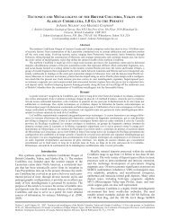
ACTIVE MINE ...... WFORMER MINE ... A*POSEDNE ...................ICROWS NESTRESOURCESBYRON CREEKKilometres"""""""""U.S.A.Figure 5-1-1. East Kootenay coalfields with mine properties located347
LOWER CRETACEOUSBLAIRMORE GROUPr.- _,