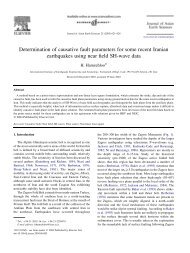
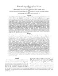
4 I. Sarkar et al. / Physics <strong>of</strong> <strong>the</strong> Earth and Planetary Interiors xxx (2005) xxx–xxx Fig. 1. (Continued ).
I. Sarkar et al. / Physics <strong>of</strong> <strong>the</strong> Earth and Planetary Interiors xxx (2005) xxx–xxx 5 M 0 = 0.92 × 10 19 ) Bam <strong>earthquake</strong> and (viii) <strong>the</strong> <strong>September</strong> <strong>16</strong>, <strong>1978</strong> (M S = 7.7) <strong>Tabas</strong> <strong>earthquake</strong>, that we investigate in this study here (Fig. 1a). <strong>Tabas</strong> <strong>earthquake</strong> is associated with a concealed Quaternary thrust fault located at <strong>the</strong> base <strong>of</strong> a series <strong>of</strong> low hills, made up <strong>of</strong> Neogene clay deposits, separating <strong>the</strong> Shotori fold-thrust mountain belt (to <strong>the</strong> east) from <strong>the</strong> <strong>Tabas</strong> playa (to <strong>the</strong> west) (Fig. 1a). Major strike slip faults, ending in thrust faults whose displacement die away towards <strong>the</strong> ends, are widespread within east-central Iran. Such faults are a manifest <strong>of</strong> <strong>the</strong> style <strong>of</strong> shear de<strong>for</strong>mation caused in <strong>the</strong> east Iranian block by <strong>the</strong> active convergence process <strong>of</strong> <strong>the</strong> Arabian and Eurasian plates and <strong>the</strong> <strong>Tabas</strong> <strong>earthquake</strong> is considered to have occurred on a listric thrust fault system (Berbarian, 1982; Walker et al., 2003). Various estimates <strong>of</strong> <strong>the</strong> <strong>Tabas</strong> hypocentral locations, based on regional (Atomic Energy Organization <strong>of</strong> Iran (AEOI); Bulletin <strong>of</strong> <strong>the</strong> Seismographic Network <strong>of</strong> Mashad University (BSNMU)) and teleseismic (National Earthquake In<strong>for</strong>mation Center (NEIC); International Seismological Centre (ISC); Harvard Centroid Moment Tensor (CMT) solution; Moscow Institute <strong>of</strong> Physics <strong>of</strong> <strong>the</strong> Earth(MOS); Centre <strong>of</strong> Seismologique, Euro-Mediterranean (CSEM); Berbarian, 1982 and Engdahl et al., 1998) recordings, are available. Of <strong>the</strong>se, <strong>the</strong> location by Engdahl et al. (1998), that is obtained on <strong>the</strong> basis <strong>of</strong> arrival times <strong>of</strong> PKiKP, PKPdf, depth phases pP, pwP, sP in addition to regional and teleseismic P and S phases, is considered by us to be better constrained. The location errors <strong>for</strong> <strong>the</strong> estimated hypocenters may be as large as 10–15 km (Berbarian, 1979a). However, it is noteworthy that <strong>the</strong> estimated epicenters all lie within 20 km from each o<strong>the</strong>r, at <strong>the</strong> sou<strong>the</strong>astern end <strong>of</strong> a geologically identified prominent surface break, believed to have been involved in <strong>the</strong> <strong>Tabas</strong> rupture process (Berbarian, 1982). The strike, dip and rake <strong>of</strong> <strong>the</strong> causative fault, estimated by different investigators from far-field data, are also varied. While <strong>the</strong> estimated strike, dip and slip <strong>of</strong> (i) Berbarian et al., (1979) viz. 332 ◦ N, 31 ◦ and 107 ◦ , respectively, from long period P-wave first motion data (ii) Niazi and Kanamori (1981) viz. 330 ◦ N, 30 ◦ , 110 ◦ , respectively, from moment tensor inversion <strong>of</strong> R 1 and R 2 phases from <strong>the</strong> IDA network and (iii) CMT solution viz. 328 ◦ N, 33 ◦ , 107 ◦ , respectively, are comparable, i.e. here <strong>the</strong> fault planes are striking in approximately WNW–ESE direction and having moderately high dips, (iv) <strong>the</strong> results <strong>of</strong> inversion <strong>of</strong> P and SH-wave<strong>for</strong>ms available from far-field WWSSN network data viz. 355 ◦ N, <strong>16</strong> ◦ and 155 ◦ (Walker et al., 2003) are somewhat different viz. here <strong>the</strong> fault plane is striking in nearly N–S direction and having low dip. The <strong>for</strong>mer interpretation <strong>of</strong> <strong>the</strong> fault plane (strike <strong>of</strong> WNW–ESE) is more in line with <strong>the</strong> regional strike <strong>of</strong> <strong>the</strong> exposed faults in <strong>the</strong> region. Several investigations suggest that <strong>the</strong> <strong>Tabas</strong> <strong>earthquake</strong> had a complex faulting process. For example, (i) a prominent, generally NNW–SSE trending surface rupture, following <strong>the</strong> low anticlinal hills <strong>of</strong> <strong>the</strong> <strong>Tabas</strong> fold system lying to <strong>the</strong> west <strong>of</strong> <strong>the</strong> Shotori ranges, possibly associated with <strong>the</strong> co-seismic phase <strong>of</strong> <strong>the</strong> <strong>earthquake</strong> process, was identified from a detailed geological investigation (Berbarian, 1979b). This rupture, about 85 km in length, was splayed into 8–10 discontinuous and randomly distributed segments that extended over a zone <strong>of</strong> about 30 km width. (ii) Berbarian (1982) analyzed local recordings <strong>of</strong> one <strong>of</strong> <strong>the</strong> major aftershock sequences and opined that faulting had initiated at a depth greater than 8 km, at <strong>the</strong> sou<strong>the</strong>rn end <strong>of</strong> <strong>the</strong> causative fault, near <strong>the</strong> basement, below <strong>the</strong> frontal sections <strong>of</strong> <strong>the</strong> Shotori fold-thrust belt and <strong>the</strong>n propagated upwards, in a northwesterly direction along listric thrust planes to intersect <strong>the</strong> earth surface as a major rupture. As <strong>the</strong> propagating fault approached <strong>the</strong> surface, it splayed into several fault segments and ruptured <strong>the</strong> surface. (iii) Walker et al. (2003) viewed such a pattern <strong>of</strong> surface de<strong>for</strong>mation as evidence <strong>of</strong> <strong>the</strong> occurrence <strong>of</strong> discrete <strong>earthquake</strong> events. These authors identified on digital topography and ASTER satellite imagery several indications <strong>of</strong> long-term and co-seismic growth within <strong>the</strong> <strong>Tabas</strong> fold system. From <strong>the</strong>se <strong>the</strong>y suggested that (a) such a fold growth had accommodated <strong>the</strong> major part <strong>of</strong> <strong>the</strong> complex fault thrust movement at depth and (b) <strong>the</strong> process <strong>of</strong> co-seismic rupture and long-term folding caused <strong>the</strong>se apparently discontinuous, surface rupture segments. (iv) Shoja- Taheri and Anderson (1988) identified four sub-events on strong motion records <strong>of</strong> <strong>the</strong> <strong>Tabas</strong> <strong>earthquake</strong> which <strong>the</strong>y inferred had occurred on <strong>the</strong> fault as <strong>the</strong> rupture propagated unilaterally in a northwesterly direction. (v) Hartzell and Mendoza (1991) analyzed strong motion records from three selected stations (<strong>Tabas</strong>, Bosroyeh and Deyhook) and also some selected WWSSN teleseismic P-wave<strong>for</strong>ms. They found that <strong>the</strong> WWSSN stations located to <strong>the</strong> sou<strong>the</strong>ast <strong>of</strong> <strong>the</strong> <strong>earthquake</strong>