The European Project GREX: Coordination and Control of ...
The European Project GREX: Coordination and Control of ...
The European Project GREX: Coordination and Control of ...

You also want an ePaper? Increase the reach of your titles
YUMPU automatically turns print PDFs into web optimized ePapers that Google loves.
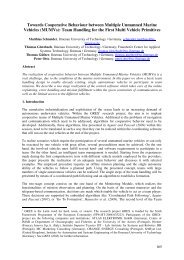
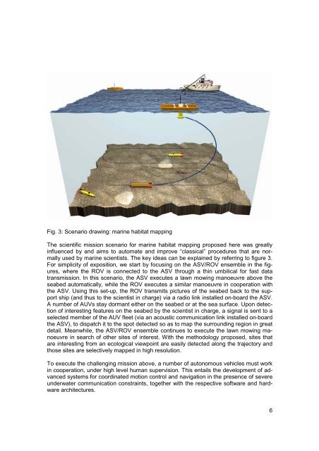
Fig. 3: Scenario drawing: marine habitat mapping<br />
<strong>The</strong> scientific mission scenario for marine habitat mapping proposed here was greatly<br />
influenced by <strong>and</strong> aims to automate <strong>and</strong> improve “classical” procedures that are normally<br />
used by marine scientists. <strong>The</strong> key ideas can be explained by referring to figure 3.<br />
For simplicity <strong>of</strong> exposition, we start by focusing on the ASV/ROV ensemble in the figures,<br />
where the ROV is connected to the ASV through a thin umbilical for fast data<br />
transmission. In this scenario, the ASV executes a lawn mowing manoeuvre above the<br />
seabed automatically, while the ROV executes a similar manoeuvre in cooperation with<br />
the ASV. Using this set-up, the ROV transmits pictures <strong>of</strong> the seabed back to the support<br />
ship (<strong>and</strong> thus to the scientist in charge) via a radio link installed on-board the ASV.<br />
A number <strong>of</strong> AUVs stay dormant either on the seabed or at the sea surface. Upon detection<br />
<strong>of</strong> interesting features on the seabed by the scientist in charge, a signal is sent to a<br />
selected member <strong>of</strong> the AUV fleet (via an acoustic communication link installed on-board<br />
the ASV), to dispatch it to the spot detected so as to map the surrounding region in great<br />
detail. Meanwhile, the ASV/ROV ensemble continues to execute the lawn mowing manoeuvre<br />
in search <strong>of</strong> other sites <strong>of</strong> interest. With the methodology proposed, sites that<br />
are interesting from an ecological viewpoint are easily detected along the trajectory <strong>and</strong><br />
those sites are selectively mapped in high resolution.<br />
To execute the challenging mission above, a number <strong>of</strong> autonomous vehicles must work<br />
in cooperation, under high level human supervision. This entails the development <strong>of</strong> advanced<br />
systems for coordinated motion control <strong>and</strong> navigation in the presence <strong>of</strong> severe<br />
underwater communication constraints, together with the respective s<strong>of</strong>tware <strong>and</strong> hardware<br />
architectures.<br />
6