Detrital Valley Basin - Arizona Department of Environmental Quality
Detrital Valley Basin - Arizona Department of Environmental Quality
Detrital Valley Basin - Arizona Department of Environmental Quality

You also want an ePaper? Increase the reach of your titles
YUMPU automatically turns print PDFs into web optimized ePapers that Google loves.
Ambient Groundwater <strong>Quality</strong> <strong>of</strong> the <strong>Detrital</strong> <strong>Valley</strong> <strong>Basin</strong>:<br />
An ADEQ 2002 Baseline Study<br />
normal pool elevation <strong>of</strong> Lake Mead.<br />
Dolan Springs is the largest community<br />
in the basin. In the DET, 27 percent <strong>of</strong><br />
land is managed by the National Park<br />
Service as part <strong>of</strong> the Lake Mead<br />
National Recreational Area. The<br />
remainder is managed by the Bureau <strong>of</strong><br />
Land Management (42 percent) and<br />
State Trust land (9 percent) or consists<br />
<strong>of</strong> private lands (22 percent).<br />
III. Hydrology<br />
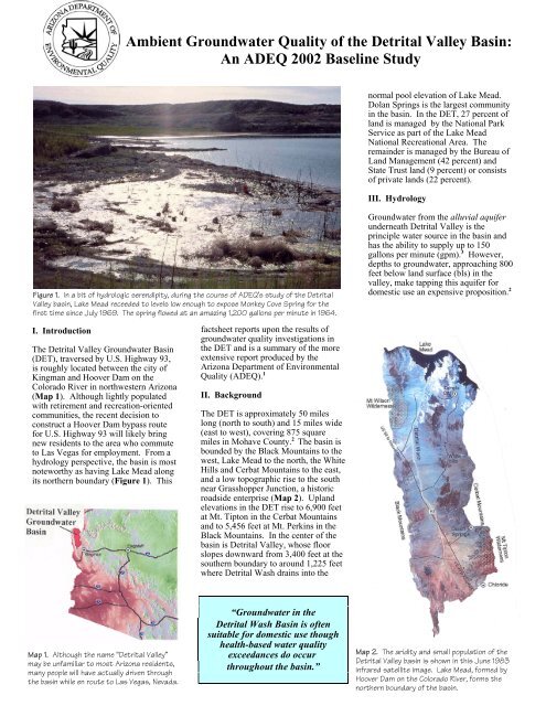
Figure 1. In a bit <strong>of</strong> hydrologic serendipity, during the course <strong>of</strong> ADEQ’s study <strong>of</strong> the <strong>Detrital</strong><br />
<strong>Valley</strong> basin, Lake Mead receeded to levels low enough to expose Monkey Cove Spring for the<br />
first time since July 1969. The spring flowed at an amazing 1,200 gallons per minute in 1964.<br />
I. Introduction<br />
The <strong>Detrital</strong> <strong>Valley</strong> Groundwater <strong>Basin</strong><br />
(DET), traversed by U.S. Highway 93,<br />
is roughly located between the city <strong>of</strong><br />
Kingman and Hoover Dam on the<br />
Colorado River in northwestern <strong>Arizona</strong><br />
(Map 1). Although lightly populated<br />
with retirement and recreation-oriented<br />
communities, the recent decision to<br />
construct a Hoover Dam bypass route<br />
for U.S. Highway 93 will likely bring<br />
new residents to the area who commute<br />
to Las Vegas for employment. From a<br />
hydrology perspective, the basin is most<br />
noteworthy as having Lake Mead along<br />
its northern boundary (Figure 1). This<br />
factsheet reports upon the results <strong>of</strong><br />
groundwater quality investigations in<br />
the DET and is a summary <strong>of</strong> the more<br />
extensive report produced by the<br />
<strong>Arizona</strong> <strong>Department</strong> <strong>of</strong> <strong>Environmental</strong><br />
<strong>Quality</strong> (ADEQ). 1<br />
II. Background<br />
The DET is approximately 50 miles<br />
long (north to south) and 15 miles wide<br />
(east to west), covering 875 square<br />
miles in Mohave County. 2 The basin is<br />
bounded by the Black Mountains to the<br />
west, Lake Mead to the north, the White<br />
Hills and Cerbat Mountains to the east,<br />
and a low topographic rise to the south<br />
near Grasshopper Junction, a historic<br />
roadside enterprise (Map 2). Upland<br />
elevations in the DET rise to 6,900 feet<br />
at Mt. Tipton in the Cerbat Mountains<br />
and to 5,456 feet at Mt. Perkins in the<br />
Black Mountains. In the center <strong>of</strong> the<br />
basin is <strong>Detrital</strong> <strong>Valley</strong>, whose floor<br />
slopes downward from 3,400 feet at the<br />
southern boundary to around 1,225 feet<br />
where <strong>Detrital</strong> Wash drains into the<br />
Groundwater from the alluvial aquifer<br />
underneath <strong>Detrital</strong> <strong>Valley</strong> is the<br />
principle water source in the basin and<br />
has the ability to supply up to 150<br />
gallons per minute (gpm). 3 However,<br />
depths to groundwater, approaching 800<br />
feet below land surface (bls) in the<br />
valley, make tapping this aquifer for<br />
domestic use an expensive proposition. 2<br />
Map 1. Although the name “<strong>Detrital</strong> <strong>Valley</strong>”<br />
may be unfamiliar to most <strong>Arizona</strong> residents,<br />
many people will have actually driven through<br />
the basin while en route to Las Vegas, Nevada.<br />
“Groundwater in the<br />
<strong>Detrital</strong> Wash <strong>Basin</strong> is <strong>of</strong>ten<br />
suitable for domestic use though<br />
health-based water quality<br />
exceedances do occur<br />
throughout the basin.”<br />
Map 2. The aridity and small population <strong>of</strong> the<br />
<strong>Detrital</strong> <strong>Valley</strong> basin is shown in this June 1983<br />
infrared satellite image. Lake Mead, formed by<br />
Hoover Dam on the Colorado River, forms the<br />
northern boundary <strong>of</strong> the basin.
Figure 2. Windmills, such as “Twin Mills”in the<br />
Black Mountains are used by ranchers for<br />
stock water. Groundwater is found at<br />
shallow levels near the mountains and<br />
historically these have been important<br />
sources <strong>of</strong> water in the <strong>Detrital</strong> <strong>Valley</strong> basin.<br />
Limited amounts <strong>of</strong> groundwater are<br />
also found in mountain hardrock areas<br />
where the bedrock is sufficiently faulted<br />
and fractured and/or where thin deposits<br />
<strong>of</strong> alluvium occur. Although usually<br />
yielding less than 50 gpm in springs and<br />
shallow wells (Figure 2), historically<br />
this has been an important water source<br />
because <strong>of</strong> its greater accessibility. 2<br />
Groundwater is also found in the Lake<br />
Mead aquifer located in northern areas<br />
adjacent to the reservoir created with<br />
the completion <strong>of</strong> Hoover Dam in 1935<br />
which impounded the Colorado River.<br />
This aquifer consists largely <strong>of</strong><br />
recharged water from Lake Mead,<br />
which has saturated the previously dry<br />
alluvium and sedimentary rocks above<br />
the level <strong>of</strong> the Colorado River.<br />
Groundwater movement in the DET is<br />
from the surrounding mountains toward<br />
the <strong>Detrital</strong> Wash and north toward<br />
Lake Mead. 2 A potential groundwater<br />
drainage divide has been reported in the<br />
northern part <strong>of</strong> the basin, which may be<br />
related to the effects <strong>of</strong> a salt body in<br />
the area which tends to impede<br />
groundwater flow to the north. 3<br />
“Groundwater in the alluvial<br />
aquifer appears to be very old,<br />
judging from isotopes and a sodium<br />
-mixed chemistry that contains<br />
trace elements such as arsenic and<br />
chromium.”<br />
Essentially all streamflow in the DET is<br />
ephemeral, generated by precipitation in<br />
the surrounding mountains. Surface<br />
flow rarely reaches the central parts <strong>of</strong><br />
the valley because <strong>of</strong> evapotranspiration<br />
and infiltration on alluvial fans, areas<br />
which provide most <strong>of</strong> the groundwater<br />
recharge. 3 The majority <strong>of</strong> the basin is<br />
drained by <strong>Detrital</strong> Wash, an ephemeral<br />
watercourse that debouches into Lake<br />
Mead at Bonelli Bay west <strong>of</strong> the resort<br />
community <strong>of</strong> Temple Bar (Figure 3).<br />
IV. Methods <strong>of</strong> Investigation<br />
This study was conducted by the ADEQ<br />
Ambient Groundwater Monitoring<br />
Program, as authorized by the<br />
legislative mandate in <strong>Arizona</strong> Revised<br />
Statutes §49-225. To characterize<br />
regional groundwater quality, 28 sites<br />
(21 wells and 7 springs) were sampled.<br />
Most sample sites were located in the<br />
southern part <strong>of</strong> the basin as few sites<br />
were available for sampling in the<br />
northern portion <strong>of</strong> the DET.<br />
Samples were collected at all sites for<br />
inorganic constituents and isotopes <strong>of</strong><br />
hydrogen and oxygen. At selected sites,<br />
samples were also collected for<br />
radiochemistry (11 sites) and radon gas<br />
(11 sites) analyses. In addition, isotope<br />
samples were collected from Lake<br />
Mead and <strong>Detrital</strong> Wash.<br />
Sampling protocol followed the ADEQ<br />
<strong>Quality</strong> Assurance Project Plan. Based<br />
on quality control data, the effects <strong>of</strong><br />
sampling equipment and procedures<br />
were not considered significant.<br />
Figure 3. The basin is largely drained by<br />
<strong>Detrital</strong> Wash, a wide, shallow, typically dry<br />
watercourse. Those unfamiliar with the<br />
intensity <strong>of</strong> desert thunderstorms find it<br />
difficult to believe that this dusty wash can<br />
quickly become a full-blown river.<br />
Map 3. The 28 <strong>Detrital</strong> <strong>Valley</strong> basin sample sites<br />
are color-coded according to water quality<br />
standard status. Health-based water quality<br />
exceedances are in red and orange, aestheticsbased<br />
water quality guidelines are in red and<br />
yellow, and blue sites have no exceedances.<br />
V. Water <strong>Quality</strong> Sampling Results<br />
The collected groundwater quality data<br />
were compared with <strong>Environmental</strong><br />
Protection Agency (EPA) Safe Drinking<br />
Water (SDW) water quality standards.<br />
Primary Maximum Contaminant Levels<br />
(MCLs) are enforceable, health-based<br />
water quality standards that public<br />
systems must meet when supplying<br />
water to their customers. Primary<br />
MCLs are not acute standards but based<br />
on a lifetime daily consumption <strong>of</strong> two<br />
liters <strong>of</strong> water. Of the 28 sites sampled,<br />
9 had constituent concentrations<br />
exceeding a Primary MCL (Map 3). At<br />
three sites each, arsenic (under<br />
standards effective in 2006), gross<br />
alpha, and nitrate concentrations each<br />
exceeded Primary MCLs.<br />
EPA SDW Secondary MCLs are<br />
unenforceable, aesthetics-based water<br />
quality guidelines for public water<br />
systems. Water with Secondary MCL<br />
exceedances may be unpleasant to drink<br />
and/or create unwanted cosmetic or<br />
laundry effects but is not considered a<br />
health concern. Of the 28 sites sampled,<br />
11 had constituent concentrations<br />
exceeding a Secondary MCL (Map 3).<br />
Constituents above Secondary MCLs
“The Lake Mead aquifer was<br />
largely created by recharge from<br />
impounded Colorado River water.<br />
The aquifer’s TDS, sulfate, and<br />
arsenic concentrations are similar<br />
to the lake water and historical<br />
data indicates it’s still evolving.”<br />
Figure 4. Most groundwater quality constituents,<br />
including TDS, decreased significantly with<br />
increasing groundwater depth bls (regression<br />
analysis, p # 0.05). Well location strongly<br />
influences this relationship since concentrations are<br />
relatively constant in deep alluvial wells but may<br />
greatly vary in hardrock wells with shallow depths.<br />
included total dissolved solids or TDS<br />
(11 sites), sulfate (7 sites), manganese<br />
(3 sites), fluoride and iron (2 sites<br />
apiece), and chloride (1 site).<br />
VI. Water <strong>Quality</strong> Exceedances<br />
The nine sites having constituents<br />
exceeding health-based water quality<br />
standards appear to be the result <strong>of</strong> by<br />
both natural and humans sources.<br />
The elevated gross alpha concentrations<br />
at two sites appear to be naturally<br />
occurring because <strong>of</strong> the surrounding<br />
granitic geology. Granite is commonly<br />
associated with elevated radiochemistry<br />
concentrations in groundwater. These<br />
constituents may be further elevated by<br />
nearby hardrock mining which exposes<br />
more rock surface.<br />
Of the three sites with elevated arsenic<br />
concentrations (all <strong>of</strong> which barely<br />
exceed the standard effective in 2006),<br />
two are deep alluvial wells which <strong>of</strong>ten<br />
have elevated concentrations <strong>of</strong> trace<br />
elements such as arsenic. 4<br />
The nitrate exceedances at two shallow<br />
windmills may be the result <strong>of</strong> livestock<br />
“Limited groundwater is normally<br />
available in hardrock mountain<br />
areas but historically it has been an<br />
important water source in the basin<br />
because <strong>of</strong> its accessibility as spring<br />
flow or from windmills pumping at<br />
shallow depths.”<br />
impacts at nearby corrals. No other<br />
nitrate sources were evident at these<br />
remote sites. The other nitrate<br />
exceedance occurred at a deep well in<br />
the alluvial aquifer and may be the<br />
result <strong>of</strong> natural soil organic matter.<br />
VII. Groundwater Composition<br />
Groundwater in the DET is generally<br />
slightly alkaline (pH > 7 standard<br />
units), fresh (TDS < 1000 milligrams<br />
per liter or mg/L), and moderately to<br />
very hard. The groundwater is most<br />
commonly <strong>of</strong> a mixed-mixed chemistry,<br />
though it varies widely in the basin.<br />
Boron, chromium, fluoride, and zinc<br />
were the only trace elements detected at<br />
more than 25 percent <strong>of</strong> sample sites.<br />
Others such as antimony, arsenic,<br />
barium, beryllium, cadmium, copper,<br />
iron, lead, manganese, mercury, nickel,<br />
selenium, silver, and thallium were<br />
rarely, if ever, detected.<br />
Many significant correlations were<br />
found among concentrations <strong>of</strong> water<br />
quality constituents. TDS was<br />
positively correlated with major ions<br />
(calcium, magnesium, sodium,<br />
potassium, chloride, and sulfate),<br />
hardness, turbidity, and boron (Pearson<br />
Correlation Coefficient test, p # 0.05).<br />
TDS concentrations were best predicted<br />
among major ions by calcium<br />
concentrations (multiple regression<br />
analysis, p # 0.01).<br />
Many groundwater quality constituent<br />
concentrations varied significantly with<br />
groundwater depth. Most constituents,<br />
including TDS (Figure 4), bicarbonate,<br />
calcium, magnesium, hardness,<br />
chloride, and sulfate decreased with<br />
groundwater depth. In contrast,<br />
temperature, pH-field, nitrate, and<br />
chromium increased with groundwater<br />
depth (regression analysis, p # 0.05).<br />
VIII. Groundwater <strong>Quality</strong> Patterns<br />
Constituent concentrations were<br />
compared statistically among aquifers.<br />
Bicarbonate (Figure 6), calcium and<br />
hardness were higher in hardrock than<br />
in the alluvial aquifer (ANOVA test in<br />
conjunction with Tukey test, p # 0.05).<br />
Bicarbonate (mg/l)<br />
Figure 5. Wells near the community <strong>of</strong><br />
Temple Bar are recharged by Colorado River<br />
water impounded in Lake Mead. ADEQ’s<br />
Doug McCarty is sampling one such well with<br />
Nevada’s Bonelli Peak rising in the distance.<br />
Elevated concentrations <strong>of</strong> these<br />
constituents are commonly found in<br />
groundwater recharge areas. 4 In<br />
contrast, temperature, nitrate, and<br />
chromium were higher in the alluvial<br />
aquifer than in hardrock. Temperature<br />
differences may be attributed to greater<br />
groundwater depths in the alluvium<br />
since temperature typically increases 3<br />
degrees Celsius with every 100 meters<br />
in depth. Chromium typically occurs in<br />
<strong>Arizona</strong> in old groundwater that<br />
receives little recharge, conditions that<br />
characterize the alluvial aquifer. 4<br />
Higher nitrate levels in deep alluvial<br />
wells are probably result from natural<br />
soil organic matter.<br />
500<br />
400<br />
300<br />
200<br />
100<br />
Alluvial<br />
Hardrock<br />
Aquifers<br />
Lake Mead<br />
Figure 6. Bicarbonate concentrations are<br />
greater in hardrock than the alluvial aquifer with<br />
Lake Mead aquifer concentrations not<br />
significantly different from either (ANOVA test<br />
in conjuction with Tukey test, p # 0.05).
Figure 6. The productivity <strong>of</strong> the alluvial<br />
aquifer is apparent in this photo. The White<br />
Hills Well was later deepened beneath a<br />
gypsum bed about 1,040 feet below land<br />
surface that intersected a deeper aquifer<br />
that dramatically increased its TDS, sulfate,<br />
and calcium concentrations.<br />
Groundwater Isotope Investigation<br />
Stable isotopes <strong>of</strong> oxygen ( 18 O) and<br />
hydrogen (deuterium or D) were<br />
collected at each DET sample site as<br />
well as from Lake Mead and <strong>Detrital</strong><br />
Wash. This data was compared to the<br />
standard reference water or Global<br />
Meteoric Water Line, which is based<br />
upon world-wide precipitation not<br />
exposed to evaporation. The DET data<br />
form a Local Meteoric Water Line<br />
whose slope <strong>of</strong> 5.15 is within the range<br />
<strong>of</strong> slopes (3 to 6) normally found in arid<br />
environments. 4<br />
The most depleted, or isotopically<br />
lightest, waters were collected from<br />
Lake Mead and nearby groundwater<br />
sites and consists <strong>of</strong> recent recharge<br />
from the Colorado River. 4 Further up<br />
the evaporation line is a tight cluster <strong>of</strong><br />
16 depleted waters consisting mainly <strong>of</strong><br />
deep alluvial wells and springs. This<br />
cluster may represent the oldest water in<br />
the basin that was recharged during a<br />
cooler time period than the present.<br />
Stretching from this cluster to the most<br />
enriched water (run<strong>of</strong>f collected after a<br />
storm in <strong>Detrital</strong> Wash) is an<br />
evaporation line <strong>of</strong> waters from 10<br />
typically shallow wells that may be a<br />
combination <strong>of</strong> older water and recharge<br />
from recent precipitation. Most <strong>of</strong> these<br />
wells are located in or near hardrock<br />
areas <strong>of</strong> the basin.<br />
The Lake Mead aquifer (Figure 5) had<br />
higher levels <strong>of</strong> oxygen and hydrogen<br />
isotopes, sodium, sulfate, and boron..<br />
These patterns are influenced by the<br />
constituent levels in the Colorado River<br />
water that recharges the aquifer.<br />
IX. Study Conclusions<br />
Limited groundwater is available in<br />
mountain hardrock but historically it<br />
has been an important water source in<br />
the DET because <strong>of</strong> its accessibility as<br />
spring flow (Figure 7) or from<br />
windmills pumping from shallow<br />
depths. Many hardrock sites have a<br />
calcium-bicarbonate chemistry, which<br />
is indicative <strong>of</strong> recharge areas. This<br />
conclusion is supported by isotope<br />
analyses. Hardrock sites also tend to be<br />
higher in salinity which may be due to<br />
recharge water traveling considerable<br />
distances through fractured bedrock,<br />
picking up dissolved salts and minerals<br />
in these weathered zones. 3<br />
In contrast, the alluvial aquifer located<br />
beneath <strong>Detrital</strong> <strong>Valley</strong> is capable <strong>of</strong><br />
producing abundant amounts <strong>of</strong> water.<br />
Often located at great depths, however,<br />
it is expensive to tap. Groundwater in<br />
this aquifer appears to be older, based<br />
upon isotope analysis, a largely mixedmixed<br />
water chemistry, and the levels <strong>of</strong><br />
trace elements such as arsenic and<br />
chromium. 4 Only a few wells in this<br />
aquifer appear to receive recent<br />
recharge. This recharge originates from<br />
percolating flow in the coarse alluvium<br />
beneath stream beds in the upper<br />
portions <strong>of</strong> alluvial fans, a pathway with<br />
less opportunity to dissolve and<br />
transport salts and minerals. 3<br />
Finally, the Lake Mead aquifer was<br />
created in the northern part <strong>of</strong> the basin<br />
by recharge from impounded Colorado<br />
River water. Limited historical data<br />
suggest its water quality is still evolving<br />
and its elevated TDS, sulfate, and<br />
arsenic concentrations are similar to<br />
those found in Lake Mead.<br />
Most groundwater in the DET meets<br />
drinking water standards. The healthbased<br />
water quality exceedances that<br />
did occur were widely scattered.<br />
Therefore, ADEQ suggests that well<br />
owners in the basin periodically have<br />
their groundwater analyzed by certified<br />
laboratories. A list <strong>of</strong> such laboratories<br />
may be obtained from the state’s<br />
<strong>Environmental</strong> Laboratory Licensure<br />
Section at (602) 255-3454.<br />
---Douglas Towne<br />
Maps by Larry W. Stephenson<br />
ADEQ Fact Sheet 03-07<br />
November 2003<br />
Figure 7. Doug McCarty <strong>of</strong> ADEQ demonstrates<br />
the agility occasionally required to collect a<br />
groundwater sample. Quail Spring is piped a<br />
short distance before discharging into the top <strong>of</strong><br />
this water tank.<br />
References Cited<br />
1. Towne, D.C., 2003, Ambient<br />
groundwater quality <strong>of</strong> the <strong>Detrital</strong><br />
<strong>Valley</strong> basin: A 2002 baseline study<br />
ADEQ OFR 03-03, 65 p.<br />
2. Dillenburg, R.A., 1987, Maps showing<br />
groundwater conditions in the <strong>Detrital</strong><br />
Wash basin, Mohave County,<br />
<strong>Arizona</strong>–1987. ADWR Hydrologic<br />
Map Series Report #14, 1 sheet.<br />
3. Geo/Resources Consultants, Inc., 1982,<br />
Groundwater resources and water<br />
quality <strong>of</strong> <strong>Detrital</strong> and Hualapai basins,<br />
Mohave County, <strong>Arizona</strong>.<br />
Unpublished Consultants Report to the<br />
BLM, 263-1H, 84 p.<br />
4. Robertson, F.N., 1991, Geochemistry <strong>of</strong><br />
ground water in alluvial basins <strong>of</strong><br />
<strong>Arizona</strong> and adjacent parts <strong>of</strong> Nevada,<br />
New Mexico, and California. U.S.G.S.<br />
Pr<strong>of</strong>essional Paper 1406-C., 90 p.<br />
For More Information Contact:<br />
Douglas C. Towne - ADEQ<br />
1110 W. Washington St. #5180C<br />
Phoenix, AZ 85007 (602) 771-4412<br />
Email: towne.doug@ev.state.az.us<br />
www.adeq.state.az.us/environ/water<br />
/assess/ambient.html#studies