Profiler EMP-400 - Alphageofisica
Profiler EMP-400 - Alphageofisica
Profiler EMP-400 - Alphageofisica

Create successful ePaper yourself
Turn your PDF publications into a flip-book with our unique Google optimized e-Paper software.
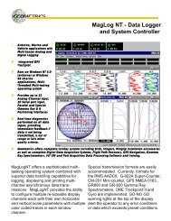
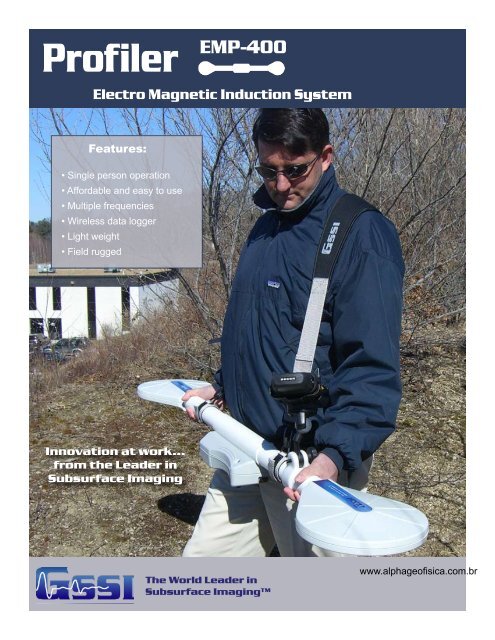
<strong>Profiler</strong> <strong>EMP</strong>-<strong>400</strong><br />
Electro Magnetic Induction System<br />
Features:<br />
• Single person operation<br />
• Affordable and easy to use<br />
• Multiple frequencies<br />
• Wireless data logger<br />
• Light weight<br />
• Field rugged<br />
Innovation at work...<br />
from the Leader in<br />
Subsurface Imaging<br />
The World Leader in<br />
Subsurface Imaging<br />
www.alphageofisica.com.br
<strong>Profiler</strong><br />
The <strong>Profiler</strong> <strong>EMP</strong> – <strong>400</strong> is a frequency<br />
domain, electromagnetic profiling system.<br />
It can be configured to simultaneously<br />
measure up to 3 frequencies between<br />
1000 Hz and 16,000 Hz with a fixed<br />
coil separation. By acquiring multiple<br />
frequencies the user can select the<br />
frequencies, which provide the best results<br />
for a specific application.<br />
Both in-phase and quadrature<br />
measurements are recorded with a time<br />
stamp. Output is the mutual coupling<br />
ratio (Q) in parts/ million (ppm) or<br />
apparent conductivity in mS/m.<br />
All survey acquisition parameters and EM<br />
data are stored on internal memory. Files<br />
are structures in Excel spread sheet format<br />
for simple download to a PC for immediate<br />
presentation on commercial mapping<br />
software packages.<br />
For geology, ground water, archaeology<br />
and environmental site assessment<br />
Real-time Display:<br />
• Survey grid coordinates<br />
• Measurement values;<br />
In-phase & Quadrature in PPM<br />
or Conductivity in mS/m<br />
• Survey navigation display<br />
• Alphanumeric or graphic<br />
data display<br />
Features:<br />
• Multi-frequency<br />
• Wireless data logger<br />
• Lightweight - less than 10 lbs<br />
• Environmentally sealed<br />
• Easy to operate<br />
• Real-time results<br />
• Low cost<br />
• Integrated GPS<br />
• Designed for signal stability<br />
• Easy to upgrade software<br />
• Flexible battery options<br />
• Durable<br />
• Easy to transport<br />
• Made with pride in the U.S.A.
Data Examples<br />
9.8 KHz in-phase VDM data showing a<br />
typical septic tank installation.<br />
Survey area: 80’ x 55’<br />
7.3 KHz in-phase VDM data file of GSSI<br />
test pit showing a series of 55-gallon<br />
drums from 3 to 5 feet in depth.<br />
Survey area: 40’ x 50’<br />
6 KHz quadrature VDM data file of<br />
a concrete pipe at 3 feet in depth.<br />
Survey area: 30’ x 30’<br />
Applications
<strong>Profiler</strong> <strong>EMP</strong>-<strong>400</strong> Specifications<br />
Preliminary<br />
Coil Spacing: 4 feet (1.25 m)<br />
Operational Bandwidth: 1 KHz to 16 KHz<br />
Records from 1 to 3 frequencies<br />
Measurement Values:<br />
• In-phase - PPM<br />
• Quadrature - PPM<br />
• Conductivity - mS/m<br />
Memory: 100,000 locations<br />
Power: re-chargeable Lithium Ion battery or<br />
8 (eight) AA batteries<br />
Display: 2.2” x 2.9” color screen (5.58 x 7.36 cm)<br />
RoHS Compliant<br />
Physical Dimensions:<br />
Length: ~57.5 inches (1.46 m)<br />
Max. Width: ~ 9.5 inches (24 cm)<br />
Max. Height: ~ 4.9 inches (12.4 cm)<br />
Weight: ~ 10 pounds (4.535 kg)<br />
<strong>Profiler</strong> System Includes:<br />
• <strong>Profiler</strong> EM system with wireless,<br />
handheld computer<br />
• 12-channel WAAS GPS (can also<br />
be integrated with external GPS)<br />
• 2 batteries<br />
• Battery charger<br />
• Carrying strap<br />
• Rugged transit case<br />
• Instruction manual<br />
• 2 year warranty<br />
System Options:<br />
• Spare battery<br />
• Spare automobile charger<br />
• Ground-level carry handle<br />
Geophysical Survey Systems, Inc.<br />
www.alphageofisica.com.br<br />
The World Leader in<br />
Subsurface Imaging<br />
12 Industrial Way<br />
Salem, NH 03079-4843<br />
Brazil - Tel: (21) 2556-1295 Fax: (21) 2205-5100<br />
info@alphageofisica.com.br<br />
Copyright © 2006 Geophysical Survey Systems, Inc.<br />
All Rights Reserved March, 2006