Excerpt from DENR Organizational Performance Indicator ... - NAMRIA
Excerpt from DENR Organizational Performance Indicator ... - NAMRIA
Excerpt from DENR Organizational Performance Indicator ... - NAMRIA

Create successful ePaper yourself
Turn your PDF publications into a flip-book with our unique Google optimized e-Paper software.
Note: <strong>Excerpt</strong> <strong>from</strong><br />
<strong>DENR</strong> <strong>Organizational</strong> <strong>Performance</strong> <strong>Indicator</strong> Framework (OPIF)<br />
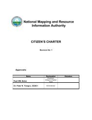
National Mapping and Resource Information Authority<br />
The National Mapping and Resource Information Authority (<strong>NAMRIA</strong>) logo depicts the basic mandate of<br />
<strong>NAMRIA</strong> as the central mapping agency of government responsible for undertaking integrated survey of the<br />
country’s water and land territories. The colors represent the areas of concern of the agency: hydrographic<br />
and oceanographic surveys conducted in water areas, (blue); topographic base mapping, land classification,<br />
and other thematic mapping activities of land area ( green); map production processes conducted in the sky<br />
(light blue) for the ground images taken through sensors and aircraft. The two overlapping triangles represent<br />
two successive exposure of aerial photographs. The overlapping areas on the ground is the stereo model that<br />
enables a three dimensional image as the basis for production of topographic maps. All these activities are<br />
conducted to cover the entire land and water area of the country, thus, the inclusion of the Philippine map (in<br />
yellow)<br />
Legal Basis<br />
Executive Order No. 192 (June 10, 1987) created the National Mapping and Resource Information Authority<br />
(<strong>NAMRIA</strong>), integrating into it the functions and powers of the Natural Resources and Management Center<br />
(NRMC), the National Cartography Authority (NCA), the Bureau of Coast and Geodetic Survey (BCGS), and<br />
the Land Classification Teams of the then Bureau of Forest Development (transformed into a Forest<br />
Management Bureau performing staff functions).<br />
Mandate<br />
The National Mapping and Resource Information Authority (<strong>NAMRIA</strong>) is the government’s central mapping<br />
agency, depository and distribution facility for natural resources data of the country. It is responsible for the<br />
establishment of a nationwide geodetic network of control points that serves as common reference system for<br />
all surveys in the country. It conducts research on remote sensing technologies and generates vital<br />
data/information on environment, land and water resources needed by government agencies and other<br />
entities as the private sector and local government units for development planning, environment and natural<br />
resource management, and delineation of maritime territories.
LOGICAL FRAMEWORK (<strong>NAMRIA</strong>)<br />
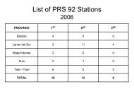
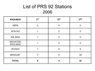
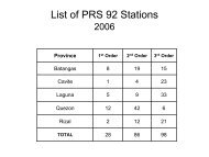
* Philippine Reference System of 1992, “new” geodetic control network adopted as the standard reference for all surveying and mapping activities pursuant to<br />
EO 45 dated January 5, 1993. Aside <strong>from</strong> upgrading the old survey system, it adopts mathematical spatial language for more effective and accurate<br />
referencing system, consistent with universal operations of mapping and surveying activities.