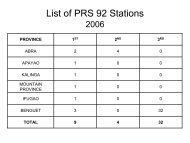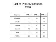
2nd - NAMRIA
2nd - NAMRIA
2nd - NAMRIA
- No tags were found...

Create successful ePaper yourself
Turn your PDF publications into a flip-book with our unique Google optimized e-Paper software.
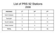
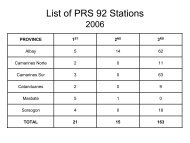
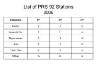
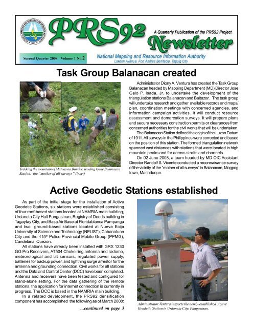
Second Quarter 2008 Volume 1 No.2Task Group Balanacan createdTrekking the mountain of Mataas na Bundok leading to the BalanacanStation, the “mother of all surveys” (inset)Administrator Diony A. Ventura has created the Task GroupBalanacan headed by Mapping Department (MD) Director JoseGalo P. Isada, Jr. to undertake the development of thetriangulation stations Balanacan and Baltazar. The task groupwill undertake research and gather available records and maps/plan, coordination meetings with concerned agencies, andinformation campaign activities. It will conduct resourceassessment and demarcation surveys. It will prepare plansand secure necessary construction permits or clearances fromconcerned authorities for the civil works that will be undertaken.The Balanacan Station defined the origin of the Luzon Datumof 1911. All surveys in the Philippines were corrected and basedon the position of this station. The formed triangulation networkspanned vast distances with stations that were located in highmountain peaks and far across straits and channels.On 02 June 2008, a team headed by MD OIC AssistantDirector Randolf S. Vicente conducted a reconnaisance surveyof the vicinity of the “mother of all surveys” in Balanacan, Mogpogtown, Marinduque.Active Geodetic Stations establishedAs part of the initial stage for the installation of ActiveGeodetic Stations, six stations were established consistingof four roof-based stations located at <strong>NAMRIA</strong> main building,Urdaneta City Hall Pangasinan, Registry of Deeds building inTagaytay City, and Basa Air Base at Floridablanca Pampangaand two ground-based stations located at Nueva EcijaUniversity of Science and Technology (NEUST), CabanatuanCity and the 415 th Police Provincial Mobile Group (PPMG),Candelaria, Quezon.All stations have already been installed with GRX 1230GG Pro Receivers, AT504 Choke ring antenna and radome,meteorological and tilt sensors, regulated power supply,batteries for backup power, and lightning surge arrestor for theantenna and grounding connection. Civil works for all stationsand the Data and Control Center (DCC) have been completed.Antenna and receivers have been tested and configured forstand-alone setting. For the data gathering of the remotestations, the application for internet connection is currently inprogress. The DCC is based in the <strong>NAMRIA</strong> main building.In a related development, the PRS92 densificationcomponent has accomplished the following as of March 2008:...continued on page 3Administrator Ventura inspects the newly-established ActiveGeodetic Station in Urdaneta City, Pangasinan.
2<strong>NAMRIA</strong> and DENR LMS meet for the 4 th -Order GCPs<strong>NAMRIA</strong> hosted a coordination meeting with the DENR-Land Management Services for the establishment of fourthorderGCPs. The meeting was held on 16 May 2008 in the<strong>NAMRIA</strong> Conference Room.Discussed in the gathering were the status of PRS92densification activities and the inventory of cadastral data sets.Also taken up were the regional targets for fourth-order PRS92densification and data integration for 2008. Officials from theDENR central office presented the policies for the release offunds for regional PRS92 densification activities. <strong>NAMRIA</strong> isin charge of releasing the funds to the regional offices for thedata transformation and integration activities.The meeting was attended by all DENR Regional TechnicalDirectors for Lands, Chiefs of regional survey divisions, andrespective staff of the DENR Planning and Policy Servicesand Financial Management Services.IEC Task Group conducts cluster trainingsThe Information, Education, and Communication (IEC)Task Group has completed three cluster trainings on AdvancedGIS using Manifold for DENR regional technical staff. Thetrainings are in support of the development, implementation,and enhancement of the Geodetic Network Information System(GNIS), and the Land Survey Database Management System(LSDMS) which were developed under the PRS92 project. Thetechnical trainings were conducted in Baguio City on 02-05June 2008 for participants from Regions I, II, and the CordilleraAdministrative Region; in <strong>NAMRIA</strong> on 16-20 June 2008 forparticipants from Regions III, IV-A, IV-B, V, and the NationalCapital Region; and in Tacloban City on 30 June-04 July 2008for participants from Regions VI, VIII, and VIII. The trainingsaimed to enhance the skills of the regional staff in theperformance of their assigned tasks in the implementation ofthe PRS92 project. The resource persons were from thetechnical staff of <strong>NAMRIA</strong>.GNIS and LSDMS are windows-, web-, and GIS-basedsystems which are capable of managing geodetic networkdata. They run on a local area network utilizing MS SQL Serverdatabase management system software.<strong>NAMRIA</strong> establishes Zero-Order Network<strong>NAMRIA</strong> started the establishment of the zero-ordernetwork with the dispatch of survey teams last 15 May. Eightfirst-order GCPs (IFG1, PNG2, PNG4, ZBS2, ZBS3, QZN7,ARA2, and MMA1) located in Banaue, Ifugao; Rosales andBolinao, Pangasinan; San Narciso and Sta. Cruz, Zambales;Nakar, Quezon; Dinalongan, Aurora; and <strong>NAMRIA</strong>, TaguigCity were observed for upgrading to zero order. The targetnumber of zero-order GCPs for establishment this year is 65.The zero-order points will have an accuracy of less than10 parts per million with a nominal spacing of approximately100 kilometers between GCPs of the network. The networkwill be useful in monitoring the dynamics of the current geodeticdatum (PRS92) and its relative accuracy on the regional (AsianRegion) scale.Administrator Ventura presides over the meetingIMD Director Papa addresses participants of one of the clustertrainings held in <strong>NAMRIA</strong>.Locations of the eight first-order GCPs
Regions visited for DI validation and assessmentThe PRS92 Data Integration (DI) component conducted aseries of regional visits to carry out the assessment of DENRregional accomplishments and targets. The said visits wereorganized to validate the accomplishments of the regions ondata transformation and integration for FY2007, assess thetargets for cadastral and other ENR data integration for FY2008,and evaluate the regional ENR datasets. The visits are a jointundertaking of the Mapping Department and the RemoteSensing and Resource Data Analysis Department which areoverseeing the cadastral and ENR data integration in theregions, respectively.For FY2007, a total of 149 municipalities/cities (~816,906lots and 3,106 reference monuments) were targeted by theregions for cadastral data transformation and integration.During the Program Review Analysis and Planning Workshopheld in New Horizon Hotel in Mandaluyong City, the regionsreported 110% accomplishment for data conversion, 66.38%for recovery, 68.94% for observation, and 9% for evaluation.All 16 regions have already been visited by the monitoringteams. There are several significant findings from the visits.Achieving the targets for data encoding is greatly affected bythe availability and quality of records; while deviations fromthe original targets were noted in some regions. Some regionshave exceeded their targets for encoding. Errors andinconsistencies in lot data computation sheets were notedduring encoding. The LSDMS is now being utilized in someregions. Concerns regarding the use of this system wereraised during the visit. The recovery and the observation ofreference monuments are still ongoing. Finally, the derivationof local transformation parameters for most regions is yet tobe conducted.Active Geodetic... from page 1277 second- and 272 third-order GCPs established andencoded in the GNIS; and 1,164 second-, 995 third-, and 2,959fourth-order GCPs established by private service providers.Under the vertical control network sub-component, <strong>NAMRIA</strong>established/releveled 1,095 benchmarks through geodeticleveling with 72 of them encoded in the GNIS. The contractorshave established/releveled 5,970 benchmarks and submitted6,127 benchmark descriptions.The draft Memorandum of Agreement for cadastral dataintegration of all the regions has also been finalized. A total of421 municipalities/cities have been targeted by the regions forFY2008. The number corresponds to 2,644,242 lots and 8420reference monuments. <strong>NAMRIA</strong> and the Land ManagementBureau (LMB) have also agreed to help the regional officesmeet the national target set this year of 566 municipalities/cities. <strong>NAMRIA</strong> committed to complete 60 municipalities whileLMB will complete 85 municipalities. The initial 30% of fundsfor the said MOA was issued to the regions during the RTD forLands Consultative Meeting held last 16 May in the <strong>NAMRIA</strong>Board Room. Meanwhile, the supplementary MOAs coveringthe other ENR data integration activities are being finalized bythe RSRDAD.The <strong>NAMRIA</strong> DI Team conducted a regional visit in DENR Region IIIOffice in San Fernando City, Pampanga.3A benchmark established in Pagsanjan, LagunaGeodetic leveling activities held in Noveleta, Cavite
4As part of the IEC program, the PRS92 project waspresented to the provinces of Pangasinan, CamarinesSur, and the Mountain Province during the second quarter.The information campaign enlightened the local executivesof the provinces on the PRS92 project, on the importanceof mojons in the locality, and on the need to protect themin order to prevent further destruction.The project was launched in Sison, Pangasinan on09 May 2008 with Representative Mark O. Cojuangco ofthe Fifth District of Pangasinan hosting the event, inpartnership with DENR Region I. <strong>NAMRIA</strong> AdministratorDiony A. Ventura expressed gratitude to RepresentativeCojuangco for supporting the PRS92 Project and formobilizing the local government heads in his district toadvocate the significance of mojons. Highlighting theoccasion were the signing of a MOA between DENRRegion I and Pangasinan fifth-district mayors for theadoption of mojons located in their respective areas andthe ceremonial establishment of a mojon.The information campaign in Camarines Sur wasconducted on 06 June 2008 during the 34 th NationalConvention and Directorate Meeting of theGeodetic Engineers of the Philippines(GEP). A MOA was signed between theprovince of Camarines Sur and DENRRegion V for the adoption of mojons inthe province.The information campaign in theMountain Province was conducted on 10June 2008. To show their full support,Mountain Province Governor MaximoDalog, Vice-Governor Louis Claver, Jr.,and Sangguniang Panlalawigan membersattended the gathering.IEC in 3 provincesFrom top to bottom: (1) Administrator Ventura andPangasinan Congressman Cojuangco during theceremonial establishment of a mojon in Sison,Pangasinan; (2) <strong>NAMRIA</strong> Asst. Dirs. Randolf S.Vicente (first from left) and Enrique A. Macaspac(fourth from right), together with GEP officials, poseat the site of the newly-established mojon in Pili,Camarines Sur; and (3) Group photo of the <strong>NAMRIA</strong>team headed by Assistant Director Macaspac and theDENR-Cordillera Administrative Region headed byRTD Victor Carantes during their courtesy call toMountain Province Governor Dalog and otherprovincial officials