Upgrading of Narayanghat- Mugling Road - About Department of ...
Upgrading of Narayanghat- Mugling Road - About Department of ...
Upgrading of Narayanghat- Mugling Road - About Department of ...

You also want an ePaper? Increase the reach of your titles
YUMPU automatically turns print PDFs into web optimized ePapers that Google loves.
Draft Executive Summary <strong>of</strong> the Environmental Assessment<br />
Report<br />
Naryanghat-<strong>Mugling</strong> <strong>Road</strong><br />
o Recommend practical and site specific environmental management and mitigation measures as may<br />
be necessary and include these in the Environmental Management Plan for the project<br />
Methodoloey<br />
15. Questionnaire and formats were developed for survey and necessary data collection.<br />
Data./information on natural/biological, physical and social parameters was generated through field<br />
surveys and literature review. Primary data and infonnation was generated through field observations and<br />
surveys, questionnaire, focus group discussion, consultation with key stakeholders and from pr<strong>of</strong>essional<br />
judgment. Stakeholders consulted with in the data collection included <strong>of</strong>ficials from Deparlments <strong>of</strong><br />
<strong>Road</strong>s, <strong>Department</strong> <strong>of</strong> Forest, <strong>Department</strong> <strong>of</strong> National Parks and Wildlife Conservation, Range Officers,<br />
Non-Government Organizations, Community Forest Users, local people and their representatives, <strong>Road</strong><br />
Users including truck and bus operators, and fishermen along the project route. GPS was used for to take<br />
reference. The field work also involved jungle treks and quadrate survey. The quadrate method was used<br />
for generating the information about the density <strong>of</strong> floral species within the specific area. The quadrate<br />
survey was done in the Barandabhar Forest Corridor. The quadrates were taken <strong>of</strong> 30x50 m along the<br />
area <strong>of</strong> forest at four different locations.<br />
16. Secondary information was collected through published and unpublished reports and maps one<br />
important source being the'Barandabhar Management Plan' prepared by the <strong>Department</strong> <strong>of</strong>Forest, Govt.<br />
<strong>of</strong>Nepal. Also secondary data were collated from reports/information <strong>of</strong>DoR.<br />
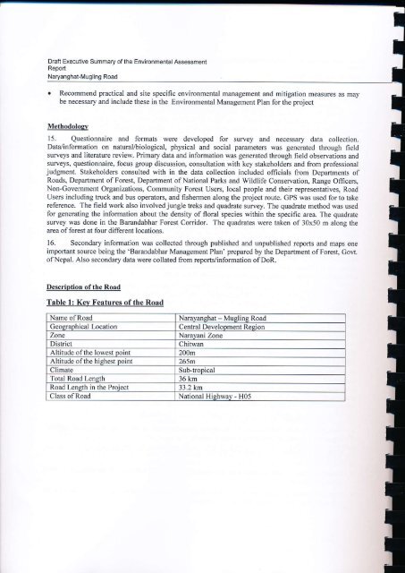
Description <strong>of</strong> the <strong>Road</strong><br />
Table 1: Kev Features <strong>of</strong>the <strong>Road</strong><br />
Name <strong>of</strong><strong>Road</strong><br />
Geographical Location<br />
Zone<br />
District<br />
Altitude <strong>of</strong> the lowest point<br />
Altitude <strong>of</strong>the hishest point<br />
Climate<br />
Total <strong>Road</strong> Length<br />
<strong>Road</strong> Length in the Proiect<br />
Class <strong>of</strong> <strong>Road</strong><br />
<strong>Narayanghat</strong> - <strong>Mugling</strong> <strong>Road</strong><br />
Central Development Resion<br />
Narayani Zone<br />
Chitwan<br />
200m<br />
265m<br />
Sub-tropical<br />
36 km<br />
33.2 km<br />
National Hishway - H05
![j:6 ]zg cfof ]hgf](https://img.yumpu.com/51286794/1/190x245/j6-zg-cfof-hgf.jpg?quality=85)
![x'nfsL /fhdfu { cfof ]hgf](https://img.yumpu.com/50581959/1/190x245/xnfsl-fhdfu-cfof-hgf.jpg?quality=85)