Nassau County - Northeast Florida Regional Council
Nassau County - Northeast Florida Regional Council
Nassau County - Northeast Florida Regional Council

Create successful ePaper yourself
Turn your PDF publications into a flip-book with our unique Google optimized e-Paper software.
12<br />
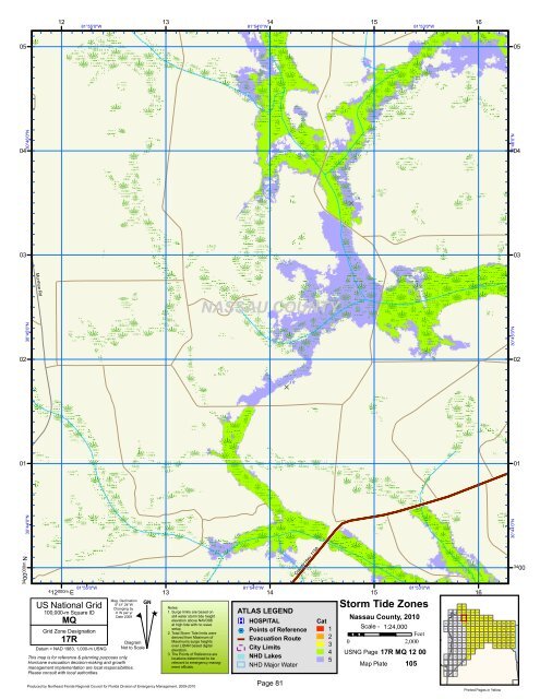
81°55'0"W<br />
13<br />
81°54'0"W<br />
14<br />
15<br />
81°53'0"W<br />
16<br />
05 05<br />
30°46'0"N<br />
04 04<br />
30°46'0"N<br />
D<br />
3 ft<br />
03 03<br />
Murrhee Rd<br />
Cabbage Creek<br />
NASSAU COUNTY<br />
30°45'0"N<br />
30°45'0"N<br />
02 02<br />
D<br />
3 ft<br />
01 01<br />
34 00 000m. N<br />
30°44'0"N<br />
30°44'0"N<br />
4 12 000m. E<br />
81°55'0"W<br />
US National Grid<br />
100,000-m Square ID<br />
MQ<br />
Grid Zone Designation<br />
17R<br />
Datum = NAD 1983, 1,000-m USNG<br />
Mag. Declination<br />
5 o 41' 24"W<br />
Changing by<br />
4' W per yr<br />
Date 2009<br />
This map is for reference & planning purposes only.<br />
Hurricane evacuation decision-making and growth<br />
management implementation are local responsibilities.<br />
Please consult with local authorities.<br />
#<br />
Diagram<br />
Not to Scale<br />
GN<br />
^<br />
13<br />
Notes:<br />
1. Surge limits are based on<br />
still water storm tide height<br />
elevation above NAVD88<br />
at high tide with no wave<br />
setup.<br />
2. Total Storm Tide limits were<br />
derived from Maximum of<br />
Maximums surge heights<br />
over LIDAR based digital<br />
elevation.<br />
3. The Points of Reference are<br />
locations determined to be<br />
relevant to emergency managment<br />
officials.<br />
81°54'0"W<br />
14<br />
<strong>County</strong> Hwy 115A<br />
ATLAS LEGEND<br />
®v HOSPITAL<br />
%2 Points of Reference<br />
Evacuation Route<br />
City Limits<br />
NHD Lakes<br />
NHD Major Water<br />
Little Saint Marys River<br />
Cat<br />
1<br />
2<br />
3<br />
4<br />
5<br />
15<br />
81°53'0"W<br />
Storm Tide Zones<br />
<strong>Nassau</strong> <strong>County</strong>, 2010<br />
Scale - 1:24,000<br />
Feet<br />
0 2,000<br />
USNG Page 17R MQ 12 00<br />
Map Plate 105<br />
16<br />
116 117<br />
109 110 111 112 113 114 115<br />
99 100 101 105 106 107 102 103 104 108<br />
83 84 85 86 87 88 89 90 91 92 93 94 95 96 97 98<br />
67 68 69 70 71 72 73 74 75 76 77 78 79 80 81 82<br />
52 53 54 55 56 57 58 59 60 61 62 63 64 65 66<br />
37 38 39 40 41 42 43 44 45 46 47 48 49 50 51<br />
24 25 26 27 28 29 30 31<br />
32 33 34 35 36<br />
18 19 20 21 22 23<br />
12 13 14 15 16 17<br />
7 8 9 10 11<br />
4 5 6<br />
1 2 3<br />
34 00<br />
Produced by <strong>Northeast</strong> <strong>Florida</strong> <strong>Regional</strong> <strong>Council</strong> for <strong>Florida</strong> Division of Emergency Management, 2009-2010<br />
Page 81<br />
Printed Pages in Yellow