Overstrand via Northrepps - Norfolk Coast Partnership
Overstrand via Northrepps - Norfolk Coast Partnership
Overstrand via Northrepps - Norfolk Coast Partnership

Create successful ePaper yourself
Turn your PDF publications into a flip-book with our unique Google optimized e-Paper software.
<strong>Overstrand</strong> <strong>via</strong> <strong>Northrepps</strong><br />
Stroll along winding rural roads, climb up steep sandy lanes and footpaths in <strong>Northrepps</strong><br />
before enjoying good views over the coast on the way back down to <strong>Overstrand</strong>.<br />
Getting started<br />
Catch Sanders bus services 4, 5 or 35 between<br />
Holt, Sheringham, Cromer and North Walsham<br />
and ask for the bus stop on the High Street in<br />
<strong>Overstrand</strong>. Timetable information can be found<br />
on the Traveline website or telephone 0871 200<br />
22 33.<br />
Unfamiliar with the area? You might find it<br />
helpful to a map with you. The Ordnance Survey<br />
Explorer Series map covering <strong>Overstrand</strong> is<br />
<strong>Norfolk</strong> <strong>Coast</strong> East, map number 252.<br />
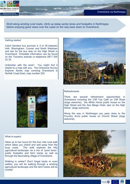
<strong>Overstrand</strong> lobster pots<br />
Refreshments<br />
There are several refreshment opportunities in<br />
<strong>Overstrand</strong> including the Cliff Top Café on Cliff Road<br />
(dogs welcome), the White Horse public house on the<br />
High Street and the Sea Marge Hotel, also on the High<br />
Street (dogs welcome).<br />
Along the way in <strong>Northrepps</strong> you pass close to the<br />
Foundry Arms public house on Church Street (dogs<br />
welcome).<br />
What to expect<br />
Allow up to two hours for this four mile rural walk<br />
which takes you inland and well away from the<br />
busy coast. The walk explores the hilly<br />
agricultural landscape <strong>via</strong> a mix of ‘quiet lanes’,<br />
public footpaths and farm tracks as well as<br />
through the fascinating village of <strong>Overstrand</strong>.<br />
Walking in winter? Don’t forget boots or even<br />
wellies: you will be walking through a working<br />
agricultural landscape and the farm tracks will be<br />
muddy!<br />
<strong>Northrepps</strong>
<strong>Overstrand</strong> <strong>via</strong> <strong>Northrepps</strong><br />
Along the way……………….<br />
The landscape<br />
This walk takes you through a rolling landscape of<br />
hills and small valleys. Narrow, winding roads link<br />
isolated farmsteads, hamlets and cottages. Most of<br />
the farmland is arable, with some smaller grazed<br />
pastures and fields around the villages. The fields<br />
are divided by hedges and also by banked field<br />
boundaries.<br />
Sidestrand<br />
You can see lots of trees and woodland on this walk.<br />
The woods tend to be relatively mature and vary<br />
from geometric shelterbelts and shooting copses to<br />
more fluid, shaped woodlands and tree belts.<br />
Along the way………………<br />
Both <strong>Overstrand</strong> and <strong>Northrepps</strong> are designated as<br />
Conservation Areas. <strong>Overstrand</strong> is most notable for<br />
the impressive buildings that sprang up from the turn<br />
of the 20th Century to the start of World War One.<br />
Following newspaper articles, books and poems by<br />
writer Clement Scott, in which he referred to the<br />
area as ‘Poppylands’, the coming of the railway to<br />
North <strong>Norfolk</strong> made the area popular with<br />
holidaymakers. The interest of the wealthy was<br />
aroused and <strong>Overstrand</strong> became known as ‘the<br />
village of millionaires’.<br />
Shrieking Pits Plantation, <strong>Northrepps</strong><br />
Explore more……..<br />
Take time to visit <strong>Northrepps</strong> Church. The great<br />
church tower of St Mary’s Church in <strong>Northrepps</strong><br />
rises above a village set in gentle valleys.<br />
St Mary’s Church, <strong>Northrepps</strong><br />
There is a splendid stained glass window in the<br />
south aisle which depicts a host of angels. The<br />
15th Century roodscreen was discovered in a local<br />
barn and moved to its present position in 1911.
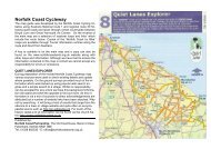
<strong>Overstrand</strong> <strong>via</strong> <strong>Northrepps</strong><br />
Walk instructions<br />
1 Start from the High Street bus stop in <strong>Overstrand</strong> and with the veterinary surgery on your<br />
right, walk to the end of the High Street. Keep right at the T-junction.<br />
Cross the road, turn left at the ‘footpath to <strong>Northrepps</strong>’ sign and walk up the public footpath<br />
over Toll’s Hill: there is a steep climb to the top starting from the corner of the allotments. Walk<br />
down the hill into <strong>Northrepps</strong>, continuing ahead as the track becomes Bull’s Row.<br />
Continue ahead at the junction beside Madam’s Lane. At the end of Bull’s Row cross the road<br />
and then turn right onto Church Street.<br />
2 Turn right onto the public footpath through the churchyard, calling in at St Mary’s Church<br />
along the way. Climb the stile out of the churchyard and continue around the edge of the field,<br />
keeping the hedge on your right.<br />
Turn left at the junction of footpaths, then left again beside Suffield House onto the farm track.<br />
3 Bear right at the end and then almost immediately left into Rectory Road. At the T-<br />
junction, cross the road to walk up the public footpath beside the wood.<br />
Keep straight on at the junction of footpaths to leave the woodland edge. Turn left at the next<br />
junction of footpaths and walk along the farm track to Hungry Hill, passing Shrieking Pits along<br />
the way. Look out for a note explaining how these ponds got their name.<br />
4 Turn left at the road in Hungry Hill, then almost immediately right onto the public<br />
footpath along another farm track. As the track bears right to the radar station, continue ahead<br />
on the footpath down the hill and under a bridge from the dismantled railway line on the way to<br />
<strong>Overstrand</strong>.<br />
Turn left on reaching Cromer Road, then first right onto <strong>Coast</strong> Road. Take the slipway leading<br />
down to the beach to enjoy a beach or promenade walk before returning up the next slipway to<br />
the village.<br />
From the top of the slipway walk up the narrow street, The Londs, to return to the bus stop on<br />
the High Street.<br />
Explore more………………. Visit <strong>Overstrand</strong> Stores on the High Street to pick up a leaflet<br />
“A Visitors Guide to <strong>Overstrand</strong> Past and Present” for a walk exploring the village. This<br />
very informative leaflet tells a brief story of the village’s prominent properties (75p).<br />
<strong>Overstrand</strong> cliffs
<strong>Overstrand</strong> <strong>via</strong> <strong>Northrepps</strong><br />
Distance 4 miles<br />
Time 2 hours<br />
Start point High<br />
Street bus stop,<br />
<strong>Overstrand</strong>. Grid ref<br />
OS map 252<br />
TG247407<br />
Public transport<br />
High Street bus<br />
stop,<br />
<strong>Overstrand</strong><br />
Services<br />
Sanders 4, 5 or 35<br />
Holt–North<br />
Walsham<br />
Refreshments<br />
<strong>Overstrand</strong>: Cliff<br />
Top café, White<br />
Horse public house,<br />
Sea Marge hotel.<br />
<strong>Northrepps</strong>: The<br />
Foundry Arms<br />
public house