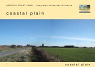
Quiet Lanes - Norfolk Coast Partnership
Quiet Lanes - Norfolk Coast Partnership
Quiet Lanes - Norfolk Coast Partnership

Create successful ePaper yourself
Turn your PDF publications into a flip-book with our unique Google optimized e-Paper software.
<strong>Norfolk</strong> <strong>Coast</strong> Cycleway<br />
The map guide was developed by the <strong>Norfolk</strong> <strong>Coast</strong> Cycling Initiative<br />
using Sustrans National route 1 and regional route 30 following<br />
quiet roads and lanes through varied countryside between<br />
King’s Lynn and Great Yarmouth via Cromer. On the reverse of<br />
the main map are a selection of ‘explorer loops and links’ which<br />
include the route below. Copies of the ‘<strong>Norfolk</strong> <strong>Coast</strong> by Bike’<br />
maps are available through Tourist Information centres along the<br />
route and direct from Sustrans.<br />
A key to symbols is on the main map and a copy can also be<br />
found on the www.norfolkcoastaonb.org.uk website along with<br />
other loops and information. Although we have tried to ensure the<br />
information contained in this map is correct we cannot accept any<br />
responsibility for errors or omissions.<br />
QUIET LANES EXPLORER<br />
During preparation of the revised <strong>Norfolk</strong> <strong>Coast</strong> Cycleway map<br />
various sources were used to check existing details and update<br />
where possible. On the ground surveys provided much of the information<br />
which was backed up using popular web search engines<br />
and a simple search to a village. Whilst no responsibility<br />
can be accepted for any errors we hope this background information<br />
will assist and whet the appetite to find out more. As this information<br />
is via a mix of sources no direct acknowledgements are<br />
attributed but a number of website links have been attached. Why<br />
not try searching - it will bring a host of results that range from the<br />
obscure to a town or village website and quite often an encyclopaedia<br />
source such as http://en.wikipedia.org. For much of the<br />
historic detail a lot of information can be found via the church history<br />
http://www.norfolkchurches.co.uk.<br />
Published by:<br />
<strong>Norfolk</strong> <strong>Coast</strong> <strong>Partnership</strong>, The Old Courthouse, Baron’s Close,<br />
Fakenham, <strong>Norfolk</strong> NR21 8BE<br />
Tel: 01328 850530 - E: office@norfolkcoastaonb.org.uk
<strong>Quiet</strong> <strong>Lanes</strong><br />
The ‘<strong>Quiet</strong> <strong>Lanes</strong>’ was a national<br />
pilot project developed in partnership<br />
with the Countryside Agency<br />
and implemented in Spring 2000.<br />
<strong>Quiet</strong> <strong>Lanes</strong> schemes aim to make<br />
minor rural links better for road users,<br />
including walkers and cyclists<br />
and horse riders. They encourage<br />
motorists to use the most suitable<br />
routes and ask all users to be considerate<br />
towards each other when<br />
travelling on a <strong>Quiet</strong> Lane. They also<br />
provide links to the public footpath<br />
and bridleway networks.<br />
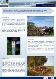
Signpost near Bradfield<br />
Map reference: A<br />
The <strong>Norfolk</strong> <strong>Coast</strong> Cycelway route<br />
out of Cromer into the <strong>Quiet</strong> <strong>Lanes</strong> but you need to take care as the<br />
road is also used to access Northrepps Caravan Park.<br />
Bacton<br />
Bacton is a small coastal community offering a sandy beach, a variety<br />
of business from accommodation to something to eat. Besides the<br />
village of Bacton, the parish includes the nearby settlements of Bacton<br />
Green, Bromholm with its ruined Cluniac Priory (now within a private<br />
farm, once famous for housing a ‘true piece of the Holy Cross), Keswick<br />
and Pollard<br />
Street. To the<br />
northwest of the<br />
parish, straddling<br />
the boundary with<br />
Paston is the UK<br />
terminal of the<br />
Interconnector<br />
gas pipleline to<br />
BactonGas Terminal<br />
Europe (left).<br />
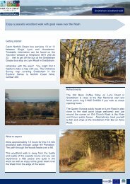
Bacton Woods<br />
Situated to the east of North Walsham the woods are open for walkers,<br />
cyclists and horse riders (information from www.northnorfolk.org.uk<br />
or Tel: 01263 513811). There has been a wood here<br />
since Saxon times, partly because of the poor quality soil for farming.<br />
On the quiet lane into North Walsham is Bacton Wood watermill at<br />
Spa Common, a Domesday site with the last working mill being rebuilt<br />
in 1747 and extensively modified for the anticipated increase in trade<br />
with the opening of the adjacent North Walsham & Dilham Canal in<br />
1826. Originally a white rendered brick and slate building. The mill<br />
house however had a <strong>Norfolk</strong> pantile roof, although, although this was<br />
later changed to slate. The new wheel was 18 feet in diameter and<br />
about 8 feet wide manufactured in cast iron. No doubt larger than previously<br />
in anticipation of an increased in head of water. The pit wheel,<br />
wallower and the spur wheel, which meshed with the wooden teeth of<br />
the stone nuts were also cast iron. The wheel powered three pairs of<br />
stones, 2 pairs were French burr stones and the other was of a composite<br />
material for animal grist.<br />
Bradfield<br />
Just off the main cycleway between Gunton and Trunch with nearby<br />
Bradfield Hall Farm providing nature walks. St Giles church (c1350) is<br />
a large church for what is now a small community but was even larger.<br />
It’s perpendicular tower has some lovely chequered patterns of lime<br />
stone and chalk although no parapet, inside is a wall painting of Christ<br />
in Judgement dating from the 15th Century. Evidence of the arcades<br />
being filled in when the aisles were demolished where pillars and<br />
arches can be seen set in the walls.<br />
Cromer<br />
Cromer became popular through its ‘Poppyland’ image in Victorian<br />
times, still a busy seaside town with all the expected facilities. Known<br />
for its Cromer Crab, famous lifeboatmen Henry Blogg, end of Pier<br />
shows it has plenty to offer. The town can obviously get very busy so<br />
do take extra great care when cycling.<br />
Although ‘Cromer’ is not mentioned in the Domesday Book two other
settlements, Shipden-juxta-mere and Shipden-juxta-Felbrigg are. It is<br />
thought Shipden-juxta-Felbrigg was around where the parish church of<br />
Saints Peter and Paul is with the other Shipden now under the sea off<br />
the north east of Cromer Pier. Its site was marked by Church Rock,<br />
but after a vessel struck the rock in 1888 the rock was blown up for<br />
safety. Its popularity as a resort started in the early-19th century, with<br />
some of the rich Norwich banking families making it their summer<br />
home. In 1883 the London journalist Clement Scott began to write<br />
about the area and named the stretch of coastline, particularly the<br />
Overstrand and Sidestrand area, "Poppyland" (due to the numerous<br />
poppies that grow on the roadside and meadows), this along with the<br />
railway brought many visitors. Now more associated with ‘Cromer<br />
Crab’ the fishermen also crewed Cromer's lifeboats with the most famous<br />
of the lifeboatmen being Henry Blogg, who received the RNLI<br />
gold medal for<br />
heroism three<br />
times, and the<br />
silver medal four<br />
times.<br />
The Lifeboat<br />
house is at the<br />
end of the Pier<br />
along with the<br />
Theatre. The<br />
first ‘jetty’ (210ft)<br />
was built in<br />
1822, destroyed<br />
21 years later<br />
and replaced<br />
with a 240ft<br />
structure which<br />
became a fashionable<br />
venue – and still is. The exposed nature of this part of the<br />
coast has meant over the years it has been damaged many times by<br />
storms and more recent in 1993 a 100ton rig severed it.<br />
Edingthorpe<br />
Just inland from Bacton is one of<br />
those little communities best appreciated<br />
from the saddle, All<br />
Saints Church with it’s thatched<br />
roof and round tower stands isolated<br />
aloft on high ground. The<br />
simple tower Saxon at the bottom<br />
and late Medieval at the top,<br />
the simple interior has many medieval<br />
survivals within. The font<br />
has simple quatrefoil panels on a tiered octagonal pedestal, on the<br />
wall behind hangs the 'Paston door', the original 12th century north<br />
door of the church. The south door and roodscreen are old too and a<br />
sequence of wall paintings probably date from the 14th century.<br />
Gimingham<br />
A village not to be missed, was known<br />
as Gimingeham in the Domesday<br />
Book - thought to come from<br />
‘homestead (ham) of Gymma’s people’<br />
(Anglo-Saxon warlord whose people<br />
settled here in 5 th to 6 th Century)<br />
and has appeared in several different<br />
versions. In 1192 as Gumingham, in<br />
1211 it appears as Gemingehem. All<br />
Saints church has elegant Tudor windows<br />
with clear glass with the intricate<br />
patterns on the framing dated from<br />
around 1300.<br />
A feature of the village is the mill pond<br />
fed from the River Mun which<br />
stretches along the western edge of the main street and is very popular<br />
with local fisherman. Close by is the rebuilt corn mill, the original<br />
watermill burnt down in 1979 (a mill was present here in the Domesday<br />
Book). The pit for the original water wheel still remains, as does<br />
the old diesel engine, which provided power to the mill for many years.
Gunton<br />
There is no Gunton village. St Andrew<br />
Church is in the grounds of<br />
Gunton Hall, one of those 18th century<br />
palaces in the middle of a large<br />
wooded estate with a deer park, a<br />
fishing lake and coverts for pheasant<br />
shooting. Gunton Station was built<br />
primarily for the convenience of Lord<br />
Suffield (a major investor in the original<br />
East <strong>Norfolk</strong> Railway Company)<br />
is on the Bittern Line and with the <strong>Norfolk</strong> <strong>Coast</strong> Cycleway signposted<br />
from the station gives an ideal opportunity to bring your cycle by train.<br />
Suffield Arms PH adjacent. Gunton Sawmill is said to be the oldest<br />
surviving water-powered sawmill in the country.<br />
Knapton<br />
Listed as ‘Kanapatone’ in the Domesday Book of 1086. The plain exterior<br />
of the 14 th Century St Peter & Paul church gives no clue to the<br />
treasure of mediaeval carving inside and evidence exists of an earlier<br />
church which no doubt housed the impressive 13th century font. One<br />
of the finest ‘double hammer beam roofs’ in the country (c1503) with<br />
fine workmanship and superb carving is probably the work of London<br />
carpenters transported to nearby Mundesley. Local tradition claims<br />
that the roof was built from a shipwreck at Mundesley. A gravestone of<br />
Commander Jeafferson Miles, RN, inscribed with the legend "the vindicator<br />
of Nelson."<br />
Mundesley<br />
In the Domesday Book as<br />
Muleslai, this popular seaside<br />
village has a good mix businesses<br />
with from shops to accommodation.<br />
The beach is<br />
sandy and the Maritime Museum<br />
is repudedly the smallest.<br />
Once a ruin this cliff edge<br />
Church of All Saints has no tower but has an unusual gallery and inspiring<br />
interior. Stow Mill, south on road to Paston was built in 1827<br />
and is open to the public (refreshments & souvenirs).<br />
North Walsham<br />
North Walsham was at the heart of the woollen and weaving industry<br />
in the 14 th Century and Church of Saint Nicholas is the largest 'Wool<br />
Church' in <strong>Norfolk</strong>. Now a busy expanding country town with a widerange<br />
of shops, refreshments and places to stay and a modern leisure<br />
centre.<br />
The present St Nicholas Church dates from the 14th century. In 1724<br />
following a double peal the tower collapsed and was at 147 ft taller<br />
than Cromer. The medieval rood screen contains images of the Apostles,<br />
the Virgin Mary and six Saints. The large alabaster monument in<br />
the Chancel is to Sir William Paston, founder of the Paston School to<br />
which Nelson once attended. A Communion table of c 1550 and a<br />
Royal Arms board used at least three times for Cromwell's Commonwealth,<br />
King Charles I and Charles II.<br />
For the historian or plain curious there is a wealth of interesting information<br />
to be found out about the area. The arrival of the weavers in<br />
the 12 th Century – nearby Worstead even gave its name to the cloth!<br />
the Peasants Revolt of 1381 and the battle of North Walsham, a wayside<br />
shrine to St. Thomas of Canterbury, Horatio Nelson, Sir William<br />
Paston, the North Walsham and Dilham Canal among others.<br />
Northrepps<br />
Much of its history is depicted on<br />
village sign, it is the seat of the<br />
Gurney family founders of what<br />
became Barclays Bank, Henry<br />
Rolls designed his car radiator<br />
grille whilst staying here, and the<br />
Gallas Plough developed here<br />
can be seen in the Church of<br />
St.Mary the Virgin. The tower is<br />
90 feet high with 8 bells, 2 of<br />
which date from the 17th century.
The font, some of the benches and the rood screen are 15th century.<br />
Foundary Arms PH even advertises it welcomes cyclists.<br />
Overstrand<br />
<strong>Quiet</strong> holiday resort,<br />
from the Anglo-<br />
Saxon ‘Ox Strand’<br />
meaning above the<br />
beach, christened<br />
’Poppyland’ by writer<br />
Clement Scott in<br />
1883.<br />
Right: Methodist<br />
Church designed by<br />
Sir Edwin Lutyen<br />
Paston<br />
Known as Pastuna in<br />
the Domesday Book<br />
the village is probably<br />
best known for its association<br />
with the Paston<br />
Mack family and<br />
the noted Paston Letters<br />
that paint a vivid<br />
picture of country life<br />
between 1422 and<br />
Paston Church 1509. The flint St Margaret<br />
church with its<br />
thatched roof dates<br />
from the 14th century. Next door is the magnificent Paston Barn, built<br />
by Sir William Paston in 1581 as a corn store. The barn constructed of<br />
flint and brick with an alternate tie and hammerbeam roof, which is<br />
thatched. The barn is 160feet (49m) long, 24feet (7.3m) wide and to<br />
the apex 60ft (18m). The barn is designated a SSSI for its bat colony.<br />
Sidestrand<br />
Name said to derive from English ‘Sid’ meaning broad and Danish<br />
‘Strond’ – shore. St Michael church is one of 124 existing round tower<br />
churches in <strong>Norfolk</strong>. Built using material from an earlier church demolished<br />
(apart from the tower which was left as a landmark) when it became<br />
too close to the cliff. The tower and graveyard known as ‘The<br />
Garden of Sleep’<br />
Southrepps<br />
Rustic village a couple of miles inland from Mundesley in two halves –<br />
Upper and Lower, possibly to do<br />
with the Black Death. The tower<br />
of the large St James Church in<br />
Upper Southrepps can be seen<br />
for miles and nearby is a village<br />
stores, Post Office and PH. In<br />
Lower Southrepps can be found<br />
Southrepps Common Local Nature<br />
Reserve comprising of 12<br />
hectares of woodland, reeds,<br />
grass and rare wild flowers.
Swafield<br />
St Nicholas Church sits<br />
proudly on a hill with<br />
beautiful views over the<br />
surrounding countryside<br />
and has one of the few<br />
remaining Medieval Rood<br />
Screens in <strong>Norfolk</strong>. Not on<br />
the designated quiet lanes<br />
but accessible by country<br />
lane from Trunch or Bradfield.<br />
(Take extreme care<br />
<strong>Quiet</strong> <strong>Lanes</strong><br />
if using the B1145 Mundesley<br />
to North Walsham road.<br />
Thorpe Market<br />
This small village has the rather unique Georgian church of St Margaret<br />
built by Lord Suffield in 1796 to replace a larger derelict one. Nowadays<br />
a lively venue for exhibitions, concerts and other cultural activities<br />
as well as regular services with an estimated 5,000<br />
people visiting the church every year. Not on <strong>Quiet</strong> <strong>Lanes</strong> and great<br />
care required as roads here can be very busy.<br />
Trunch<br />
A village that boasts a well stocked Stores/PO along with a pub. The<br />
Church of St Botolph is famous for its carved and painted wood canopy<br />
(one of four to still exist in England) also features a hammerbeam<br />
roof with carved angels, as well as medieval misericords under the<br />
seats in the chancel. Lord Nelson’s daughter is said to have been married<br />
here.<br />
Witton<br />
Take a walk to the far side of the churchyard at St Margaret’s Church,<br />
Witton for a vast view of the North <strong>Norfolk</strong> coast and countryside. It<br />
takes in several churches – including the ruined Bromholm Priory<br />
(private) at Bacton and the red and white striped Happisburgh lighthouse.<br />
(Below: curiously named Witton Bridge!)<br />
Trimingham<br />
Three quiet lanes lead up to Trimingham and a visit to the Church of<br />
St John the Baptist’s Head - the strange dedication dates from the medieval<br />
period when a life size alabaster head of the saint which was<br />
kept at the church and pilgrims came, rather than make the journey to<br />
Amiens Cathedral were a relic said to be the real head of was kept.<br />
The alabaster head did not survive, probably destroyed as a result of<br />
an injunction in 1538 or 1547. The nearby Village hall is called pilgrim<br />
shelter as a reminder of Trimingham’s past. The remote air defence<br />
radar station shaped like a giant golf ball can be seen<br />
for miles around. Unfortunately no shops or cafes<br />
here although along the coast road towards Cromer<br />
is Woodlands Caravan Park has many facilities open<br />
to the public.