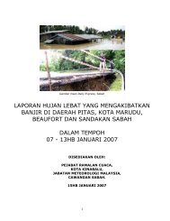
Report On Heavy Rainfall That Caused Floods in Johore and south ...
Report On Heavy Rainfall That Caused Floods in Johore and south ...
Report On Heavy Rainfall That Caused Floods in Johore and south ...

Create successful ePaper yourself
Turn your PDF publications into a flip-book with our unique Google optimized e-Paper software.
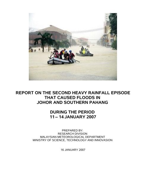
REPORT ON THE SECOND HEAVY RAINFALL EPISODE<br />
THAT CAUSED FLOODS IN<br />
JOHOR AND SOUTHERN PAHANG<br />
DURING THE PERIOD<br />
11 – 14 JANUARY 2007<br />
PREPARED BY:<br />
RESEARCH DIVISION<br />
MALAYSIAN METEOROLOGICAL DEPARTMENT<br />
MINISTRY OF SCIENCE, TECHNOLOGY AND INNOVASION<br />
16 JANUARY 2007
1.Introduction<br />
Johor <strong>and</strong> <strong>south</strong>ern Pahang experienced a second heavy ra<strong>in</strong>fall episode from 11 to 14<br />
January 2007. This heavy ra<strong>in</strong>fall episode was the first event <strong>in</strong> which heavy ra<strong>in</strong>fall reoccurred<br />
with<strong>in</strong> a period of 22 days (19 December 2006 – 11 January 2007). This abnormal heavy ra<strong>in</strong>fall<br />
event was due to the convergence of the strong w<strong>in</strong>ds from the western Pacific Ocean <strong>and</strong> the<br />
northeasterly surge form Rusia/ Ch<strong>in</strong>a over the South Ch<strong>in</strong>a Sea.<br />
2.Analysis of ra<strong>in</strong>fall from 11 – 14 January 2007<br />
Table 1: Daily Accumulated <strong>Ra<strong>in</strong>fall</strong> (mm) from 11 January 2007 to 14 January 2007<br />
State<br />
Station<br />
Thursday<br />
(11/1/07)<br />
Friday<br />
(12/1/07)<br />
Saturday<br />
(13/1/07)<br />
Sunday<br />
(14/1/07)<br />
Total<br />
Pahang<br />
Muadzam<br />
Shah<br />
67.0 58.0 69.0 36.0 230.0<br />
Johor Mers<strong>in</strong>g 64.0 134.0 237.0 167.0 602.0<br />
Senai 264.0 213.0 9.0 19.0 505.0<br />
Kluang 171.0 222.0 42.0 16.0 451.0<br />
Batu Pahat 121.0 94.0 9.0 0.4 224.4<br />
Table 2: January Accumulated <strong>Ra<strong>in</strong>fall</strong> (1/1/2007-14/1/2007) <strong>in</strong> comparison with the Monthly<br />
Accumulated Mean.<br />
State Station<br />
Total <strong>Ra<strong>in</strong>fall</strong> (mm) Monthly Mean Monthly Monthly<br />
1/1/07 - 14/1/07 (mm) Maximum (mm) M<strong>in</strong>imum (mm)<br />
Pahang Muadzam Shah 298.6 267.0 644.0 8.0<br />
Johor Mers<strong>in</strong>g 739.2 328.0 834.0 1.0<br />
Senai 607.0 194.0 478.0 8.0<br />
Kluang 488.4 158.0 496.0 1.8<br />
Batu Pahat 275.8 167.0 301.0 27.0<br />
Table 1 <strong>in</strong>dicates that the daily ra<strong>in</strong>fall recorded at Mers<strong>in</strong>g station from 11 until 13 January<br />
has <strong>in</strong>creased dur<strong>in</strong>g these 3 days. Daily ra<strong>in</strong>fall recorded at Mers<strong>in</strong>g station started to decrease on<br />
14 January 2007. Kluang station also had recorded an <strong>in</strong>crease <strong>in</strong> the daily ra<strong>in</strong>fall from 11 until 12<br />
January 2007. <strong>On</strong> 13 <strong>and</strong> 14 January 2007, the daily accumulated ra<strong>in</strong>fall had decreased drastically<br />
to 42.0 mm <strong>and</strong> 16.0 mm. <strong>On</strong> 11 Januari 2007, Senai <strong>and</strong> Batu Pahat stations started to record daily<br />
ra<strong>in</strong>fall of about 264.0 mm <strong>and</strong> 121.0 mm respectively. The daily ra<strong>in</strong>fall began to decrease on<br />
12 January 2007. <strong>On</strong> 13 <strong>and</strong> 14 January 2007, there was a further decrease <strong>in</strong> the daily ra<strong>in</strong>fall. For<br />
the period of 11 to 14 January 2007, the daily ra<strong>in</strong>fall recorded by Muadzam Shah station was<br />
almost similar to the January monthly mean. The daily accumulated ra<strong>in</strong>fall recorded by all stations<br />
except Muadzam Shah station exceeded the January monthly mean for the respective stations.<br />
(Refer Table 2).
3.Radar imageries from 11 – 14 January 2007<br />
Weather radar imageries from the radar network stations <strong>in</strong> Pen<strong>in</strong>sular Malaysia are shown <strong>in</strong><br />
Appendix A. (Figure (a) to (h)) shows the development of the heavy ra<strong>in</strong>fall occurrence <strong>in</strong> detail.<br />
Radar imageries were taken <strong>in</strong> twelve hour <strong>in</strong>tervals start<strong>in</strong>g from the 11 January 2007 (8.00 am)<br />
until the 14 January 2007 (8.00 pm). These imageries are a composite of radar echoes taken from<br />
the six weather radar stations <strong>in</strong> Pen<strong>in</strong>sular Malaysia. The development of the heavy ra<strong>in</strong>fall event<br />
could be seen from the sequence of the radar echoes. Johor <strong>and</strong> <strong>south</strong>ern Pahang have been<br />
receiv<strong>in</strong>g heavy ra<strong>in</strong>fall start<strong>in</strong>g on 11 January 2007. The ra<strong>in</strong>fall <strong>in</strong>tensity <strong>in</strong> both states <strong>in</strong>creased<br />
<strong>and</strong> peaked on 12 January 2007 (8.00 pm). Most of the ra<strong>in</strong>fall was concentrated <strong>in</strong> Johor. <strong>On</strong> 13<br />
January (8.00 pm), the ra<strong>in</strong>fall was still concentrated <strong>in</strong> the same state but with reduced <strong>in</strong>tensity.<br />
<strong>On</strong> 14 January 2007, the ra<strong>in</strong>fall <strong>in</strong> Johor began to reduce substantially.<br />
4.Weather Satellite Imageries from 11 – 14 January 2007<br />
MTSAT weather satellite imageries from 11 until 14 January 2007 are shown <strong>in</strong> Appendix<br />
B (Figure (a) to (h)). Cloud developments were observed over the <strong>south</strong>ern part of Pen<strong>in</strong>sular<br />
Malaysia on 11 January 2007 (8.30 am). Cloud <strong>in</strong>tensity decreased further on 12 January 2007<br />
(8.30 am) but re-<strong>in</strong>tensified at 8.30 pm. <strong>On</strong> 13 January 2007 around 8.30 am ra<strong>in</strong> clouds began to<br />
cover <strong>south</strong>ern Pen<strong>in</strong>sular Malaysia. However, the situation began to improve by 8.30 pm. Cloud<br />
development began to decrease at 8.30 am, 14 January 2007.<br />
5.Conclusion<br />
The Northeast monsoon is currently active over the South Ch<strong>in</strong>a Sea <strong>and</strong> is expected to<br />
cont<strong>in</strong>ue until 20 January 2007. Moderate to occasionally heavy ra<strong>in</strong>fall is still expected over Johor<br />
<strong>and</strong> Pahang.
APPENDIX A<br />
Sequence of Radar Imageries at 8.00 am <strong>and</strong> 8.00 pm from 11 to 14 January 2007 [(a) to (h)]<br />
a) 8.00 am, 11 January 2007 b) 8.00 pm, 11 January 2007<br />
c) 8.00 am, 12 January 2007 d) 8.00 pm, 12 January 2007
APPENDIX A (cont<strong>in</strong>ued)<br />
e) 8.00 am, 13 January 2007 f) 8.00 pm, 13 January 2007<br />
l<br />
g) 8.00 am, 14 January 2007 h) 8.00 pm, 14 January 2007
APPENDIX B<br />
Sequence of MTSAT Weather Satellite Images at 8.30 am <strong>and</strong> 8.30 pm<br />
from 11 to 14 January 2007 [(a) to (h)]<br />
(a) 8.30 am, 11 January 2007 (b) 8.30 pm, 11 January 2007<br />
(c) 8.30 am, 12 January 2007 (d) 8.30 pm, 12 January 2007
APPENDIX B (cont<strong>in</strong>ued)<br />
(e) 8.30 am, 13 January 2007 (f) 8.30 pm, 13 January 2007<br />
(g) 8.30 am, 14 January 2007 (h) 8.30 pm, 14 January 2007