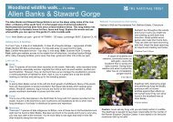
Ashurst Wood High Weald Welly Walk - Walk4Life
Ashurst Wood High Weald Welly Walk - Walk4Life
Ashurst Wood High Weald Welly Walk - Walk4Life

Create successful ePaper yourself
Turn your PDF publications into a flip-book with our unique Google optimized e-Paper software.
The <strong>High</strong> <strong>Weald</strong> Area of Outstanding Natural Beauty<br />
(AONB) is one of England’s Finest Landscapes, protected<br />
for its historic character of: rolling hills draped with small<br />
irregular fields; abundant woods and hedges; scattered<br />
farmsteads; and sunken lanes. It covers parts of 4 counties:<br />
East Sussex, West Sussex, Kent and Surrey and has an area<br />
of 1,457 square kilometres (570 square miles).<br />
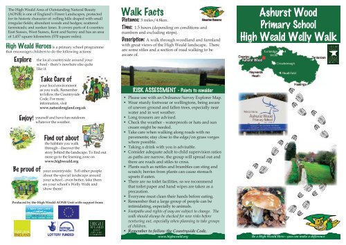
<strong>High</strong> <strong>Weald</strong> Heroes is a primary school programme<br />
that encourages children to do the following actions:<br />
Explore<br />
Enjoy!<br />
Be proud of<br />
the local countryside around your<br />
school - there’s nowhere else quite<br />
like it.<br />
Take Care of<br />
your local environment<br />
as you walk. Remember<br />
to follow the Countryside<br />
Code. For more<br />
information, visit<br />
www.naturalengland.org.uk<br />
yourself and have fun outdoors<br />
whatever the weather.<br />
Find out about<br />
the habitats you walk<br />
through - discover the<br />
story behind the landscape. To find out<br />
more go to the learning zone on<br />
www.highweald.org<br />
your countryside. Tell other people<br />
about the special landscape around<br />
your school - even better, take them<br />
on your school’s <strong>Welly</strong> <strong>Walk</strong> and<br />
show them!<br />
Produced by the <strong>High</strong> <strong>Weald</strong> AONB Unit with support from:<br />
<strong>Walk</strong> Facts<br />
Distance: 3 miles/4.8km.<br />
Time: 1.5 hours (depending on conditions and<br />
numbers and excluding stops).<br />
Description: A walk through woodland and farmland<br />
with great views of the <strong>High</strong> <strong>Weald</strong> landscape. There<br />
are some stiles and a section of road walking to be<br />
aware of.<br />
RISK ASSESSMENT - Points to consider<br />
• Please use with an Ordnance Survey Explorer Map.<br />
• Wear sturdy footwear or wellingtons, being aware<br />
of uneven ground and fallen trees, especially near<br />
water and in wet weather.<br />
• Long trousers are advised.<br />
• Check the weather - waterproofs or hats and sun<br />
cream might be needed.<br />
• Take care when walking along roads with no<br />
pavements; stay close to the edge/on grass verges<br />
where possible.<br />
• Taking a drink with you is advisable.<br />
• Consider adequate adult to child supervision ratios<br />
as paths are narrow, the group will spread out and<br />
there are roads and stiles to cross.<br />
• Plants such as nettles and brambles can sting and<br />
scratch; berries from plants can cause stomach<br />
upsets if eaten.<br />
• There are no toilet facilities, so we recommend<br />
that toilet paper and hand wipes are taken as a<br />
precaution.<br />
• Everyone must clean their hands before eating.<br />
• Remember that a large group of people can be<br />
intimidating, especially to animals.<br />
• Footpaths and rights of way are subject to change. The<br />
walk should always be checked for new risks before<br />
venturing out, especially when planning to take groups<br />
of children.<br />
• Remember to follow the Countryside Code.<br />
www.highweald.org<br />
<strong>Ashurst</strong> <strong>Wood</strong><br />
Primary School<br />
<strong>High</strong> <strong>Weald</strong> <strong>Welly</strong> <strong>Walk</strong><br />
<strong>Ashurst</strong> <strong>Wood</strong><br />
Be a <strong>High</strong> <strong>Weald</strong> Hero - you can make a difference
1<br />
2<br />
3<br />
4<br />
5<br />
6<br />
7 8<br />
9<br />
10<br />
11<br />
12<br />
For guidance only; actual conditions may be different from those shown, depending on the weather and time of year.<br />
Photo guide and route description<br />
From the school gate, turn left and walk past the end of Dirty Lane, round to the end of School Lane. Turn left at the main road (Hammerwood Road) and walk along the pavement<br />
to where the road splits. Take the right hand fork down Cansiron Lane 1 . Follow this road for some distance, taking care as there are no pavements. At Grove Farm Cottage,<br />
follow the road round to the right and walk up to the next bend. Now look for the narrow footpath on your right by a gate, heading between the trees 2 .<br />
Follow the footpath all the way downhill. Stay on the main path and eventually you will reach a gate. Go through this and walk along the right hand edge of the field 3 . At<br />
the gap in the line of fencing on your right, follow the path away from the field, heading towards the buildings and through a metal gate. At the tarmac road turn left towards<br />
Tablehurst Farm. Just before the entrance to the farm, turn right off the path following signs to Forest Way Country Park 4 . Follow the Forest Way path as it widens out to<br />
become a tree lined track. Cross a bridge and then, shortly afterwards, look out for steps down to a stile on your left 5 . Go down the steps, across the stile and head diagonally<br />
across the field towards the bridge. Cross over and carry straight on through a small field to reach another bridge. Once over this, carry straight on up the footpath.
At the graveled picnic area, turn left (towards the farm buildings) but then turn right along the main farm track 6 , heading uphill, away from the picnic area. Follow the concrete<br />
track all the way uphill with open fields on either side – make sure you turn around and enjoy the view behind you! Keep going until the path enters a patch of woodland. Follow<br />
the path to the right and then along a narrower fenced footpath 7 (following public footpath arrows). Keep the woods on your left, fields and electric fence on your right. Go<br />
through a gate and carry straight on across a small field to another gate in the corner 8 . Go through this and bear slightly left as you walk through the field, towards the corner<br />
of the fence 9 . Follow the path uphill, fence on your left, trees to your right. Keep going until you reach a junction of paths. Turn right and walk up to the gate 10 . Once<br />
through the gate turn sharply left and walk across the field heading towards the electricity pylon 11 . Find the footpath to the right of the pylon and follow it between the trees. Go<br />
through the kissing gate ahead of you and turn left to enter a large open field. Follow the footpath down and across the field, towards the house 12 . Go through the gate and keep<br />
to the right hand edge of the field as it curves round to the right and meets another gate. Go through here and turn left to walk along the driveway, away from the house (Windmill<br />
Cottage).<br />
At the end of the drive carry straight on and walk along the road, taking care as there are no pavements. You will soon arrive back at<br />
Retrace your steps back along Cansiron Lane, School Lane and return to <strong>Ashurst</strong> <strong>Wood</strong> Primary School!<br />
Look out for...<br />
Sunken Lane<br />
1<br />
Cansiron Lane<br />
!<br />
2<br />
Sandhurst Lane<br />
Grove Farm<br />
Cottage<br />
Windmill<br />
(Disused)<br />
12<br />
11<br />
10<br />
2<br />
School<br />
, the corner where you previously walked.<br />
Key<br />
<strong>Ashurst</strong> <strong>Wood</strong><br />
Primary School<br />
WALK ROUTE<br />
1 numbered views<br />
suggested<br />
activity point<br />
historic<br />
routeway<br />
Rolling Hills<br />
Duck & Drake<br />
Toad Hall<br />
3<br />
Forest Way<br />
Tablehurst Farm<br />
Alder Lane 4<br />
5<br />
6<br />
7<br />
8<br />
9<br />
!<br />
wildflower<br />
grassland<br />
road<br />
watercourse<br />
take care, no<br />
pavements on<br />
this road<br />
This map is reproduced from Ordnance Survey material<br />
with the permission of Ordnance Survey on behalf of the<br />
controller of Her Majesty’s Stationery Office. ©Crown<br />
Copyright . Unauthorised reproduction infringes<br />
Crown Copyright and may lead to prosecution or civil<br />
proceedings. West Sussex County Council - 1000 18485,<br />
2011.
Ancient <strong>Wood</strong>land<br />
Trees and woodland cover over one-third of the <strong>High</strong> <strong>Weald</strong><br />
and are a key landscape feature that you can enjoy on this<br />
<strong>Welly</strong> <strong>Walk</strong>.<br />
The woods of the <strong>High</strong> <strong>Weald</strong> were relatively slow to be<br />
cleared because they were a valuable resource: providing<br />
timber for building, fuel for heating and charcoal for iron<br />
smelting, as well as animal feed - acorns and beech mast for<br />
pigs. Even when agricultural clearance did begin in the <strong>High</strong><br />
<strong>Weald</strong>, much woodland was retained and continued to<br />
provide valuable resources, particularly for the iron industry.<br />
Today, 70% of the <strong>High</strong> <strong>Weald</strong>’s woodlands are classed as<br />
ancient - having existed continuously since at least 1600AD.<br />
They have been maintained for centuries by skilled workers<br />
using a rotational coppicing system.<br />
Coppicing is when trees are cut down low to the ground in<br />
such a way that the stems grow back afterwards. The trees<br />
are cut once every 10-15 years. The harvested wood is used to<br />
make products such as fencing stakes, charcoal, hurdles and<br />
trugs. Buying local wood products helps to ensure the<br />
continuation of traditional management.<br />
Look out for signs of coppicing on your <strong>Welly</strong> <strong>Walk</strong> -<br />
can you spot a tree with multiple trunks?<br />
When the trees are coppiced,<br />
the light can reach right down<br />
to the ground as the branches<br />
and leaves are no longer shading<br />
the floor. This means lots of<br />
wild plants can grow including<br />
bluebells, wood anemones and<br />
wild garlic. These plants attract<br />
insects to feed on the nectar, and<br />
birds and small mammals eat the<br />
fruits and seeds.<br />
Often, rarer species are now only<br />
found in working coppice.<br />
Ancient Routeways<br />
As far back as the Neolithic period (c.4500 - 2300BC) farmers<br />
from the Downs and coastal plains would drive their pigs into<br />
the woods each year to fatten them on acorns and beech mast.<br />
This happened during the late summer and early autumn, and<br />
the farmers would have<br />
built temporary shelters to<br />
keep warm while watching<br />
their pigs. These woodland<br />
pig pastures were called<br />
dens. Many places in the<br />
<strong>High</strong> <strong>Weald</strong> have names<br />
ending in den - for example<br />
Standen, Cowden.<br />
The frequent passage of<br />
pigs being driven to and from the dens formed tracks known<br />
as droves. Over time the dens became settlements in their own<br />
right, and the roughly north-south droving routes remained.<br />
They can be seen today in the pattern of lanes, bridleways and<br />
footpaths radiating away from the <strong>High</strong> <strong>Weald</strong>.<br />
Centuries of use by many trotters, feet, hooves - and, later,<br />
cartwheels - have worn the soft ground away so that, today,<br />
many of the routes have deeply sunken sections. Look out<br />
for this as you walk down Cansiron Lane - just before Grove<br />
Farm Cottage.<br />
Look closely at the map in this <strong>Welly</strong> <strong>Walk</strong> leaflet<br />
to see where historic routeways exist in and around<br />
<strong>Ashurst</strong> <strong>Wood</strong>.<br />
A Medieval Landscape<br />
By the 14th century, the <strong>High</strong> <strong>Weald</strong> was settled and looked<br />
much the same as it does today. The landscape of the <strong>High</strong><br />
<strong>Weald</strong> is essentially medieval - this can be said of few other<br />
places in the country. With their heavy clay soils and steep<br />
slopes, many <strong>High</strong> <strong>Weald</strong> fields have<br />
never been ploughed up to grow crops<br />
and have traditionally been used for<br />
rearing cattle and sheep.<br />
Compared to many areas of Britain,<br />
the <strong>High</strong> <strong>Weald</strong> still has a relatively<br />
large number of ancient, undisturbed,<br />
wildflower-rich hay meadows and<br />
pastures - examples of which you can see<br />
on this <strong>Welly</strong> <strong>Walk</strong>. These ‘unimproved’<br />
grasslands are some of our most important habitats for<br />
conservation, supporting up to 100 kinds of grasses and<br />
wildflowers - which, in turn, support a great variety of insects<br />
and other creatures.<br />
The <strong>High</strong> <strong>Weald</strong> Iron Industry<br />
For two periods - in the first two centuries of the<br />
Roman occupation, and during Tudor and early -<br />
Stuart times - the <strong>Weald</strong> was the main iron-producing<br />
region in Britain.<br />
It is hard to picture the<br />
former iron industry in<br />
today’s countryside of small<br />
fields, woodlands and steep,<br />
narrow, gill valleys, but in<br />
this landscape exist all the<br />
necessary raw materials that<br />
allowed iron to be smelted for<br />
over 2,000 years. The <strong>Weald</strong>en<br />
geology of sands and clays yielded the iron ore, as well as the<br />
stone and brick to build the furnaces; the coppiced woodland<br />
provided charcoal for fuel; and the numerous small streams<br />
and valleys ensured water power for the hammers and bellows<br />
of the forges and furnaces.<br />
This <strong>Welly</strong> <strong>Walk</strong> passes by the site of a bloomery - a small<br />
furnace that would have been used in Roman times to smelt<br />
iron. In fact, there are numerous former iron working sites<br />
scattered in and around <strong>Ashurst</strong> <strong>Wood</strong>.<br />
Local iron-related place names such as Hammerwood<br />
Road give us clues of the industry that used to exist in<br />
this area.<br />
So, where are the remains of such industry? Building<br />
stone was too valuable to be left unused, so the works were<br />
dismantled, and the woods grew back over the former<br />
sites. Reminders of the once great <strong>Weald</strong>en iron industry can<br />
be found in place names, remains of charcoal hearths or pits<br />
in the woods - flattened circular areas with blackened soil<br />
beneath the leaf litter - or in finding chunks of telltale waste,<br />
called slag, from the smelting process.<br />
Adapted from text by Jeremy Hodgkinson, <strong>Weald</strong>en Iron Research Group.<br />
Forest Way<br />
Forest Way, a former railway line, forms<br />
part of this <strong>Welly</strong> <strong>Walk</strong>. The line was<br />
opened in 1866 and, although initially a<br />
busy commuter line, it was closed under<br />
the Beeching cuts in 1966. Ironically,<br />
Dr Beeching lived near Forest Row and<br />
regularly travelled up to London on the line<br />
when he was Chairman of British Rail.<br />
Many of the trees along Forest Way and in<br />
the surrounding fields are alder or willow.<br />
This is because it lies in the floodplain of<br />
the River Medway and these trees thrive in<br />
damp surroundings.