Dam Synchronisation and Flood Releases - agriwaterpedia.info
Dam Synchronisation and Flood Releases - agriwaterpedia.info
Dam Synchronisation and Flood Releases - agriwaterpedia.info

Create successful ePaper yourself
Turn your PDF publications into a flip-book with our unique Google optimized e-Paper software.
DAM SYNCHRONISATION AND FLOOD RELEASES IN THE ZAMBEZI RIVER BASIN PROJECT: ANNEX 1 OF FINAL REPORT<br />
3.3 Maps<br />
One of the great strengths of the ZAMWIS database is the availability digital spatial data in the<br />
form of digitized maps. To view them, ZAMWIS has a Firefox based application called ―Zamwis<br />
Basin Atlas‖ with which the user can interface with all the maps. There are three categories of<br />
maps presented, these being interactive maps, static maps <strong>and</strong> GIS projects <strong>and</strong> data. The<br />
interactive maps allow the user to turn on-<strong>and</strong>-off different layers, as well as zoom in on subsections<br />
of the Basin. The static maps are jpeg images which are static graphically depictions of a<br />
particular theme across the entire Basin. The GIS projects <strong>and</strong> data allow the user to access the<br />
*.mxd files when using ArcGIS.<br />
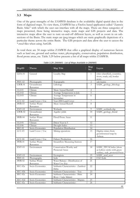
In total there are 34 maps within ZAMWIS that offer a graphical display of numerous factors<br />
such as l<strong>and</strong> use, ground <strong>and</strong> surface water, physiography, conservation, population distribution,<br />
flood prone areas, etc. Table 3.29 below presents a list of all maps within ZAMWIS.<br />
MapID Theme Map Title<br />
Table 3.29: ZAMWIS - List of Maps Available in ZAMWIS<br />
Map<br />
No<br />
Layers<br />
GEN-01 General Locality Map 1 cities (classified), countries,<br />
rivers, roads, rail, border<br />
posts<br />
PHY-02 Physiography Topography 2 sub-basins<br />
GWR-01 Groundwater Lithology 3 SADC_geology_lithology<br />
Resources<br />
CLI-01 Climate Mean Annual Rainfall 4<br />
CLI-02 Climate Average Temperature in July 5<br />
CLI-03 Climate Average Temperature in<br />
6<br />
November<br />
LCU-02 L<strong>and</strong> Cover / Use Year 2000 L<strong>and</strong> Cover 7<br />
SWR-03 Surface Water Mean Annual Runoff 8<br />
Resources<br />
ENV-02 Environment Wetl<strong>and</strong>s 9 SADC_wetl<strong>and</strong>s.shp<br />
GWR-02 Groundwater Aquifer yields 10 SADC_geology_friend<br />
Resources<br />
SWR-04 Surface Water <strong>Flood</strong> Prone Areas 11<br />
Resources<br />
CLI-05 Climate Driest Year in 5 12<br />
CLI-06 Climate Drought Index 13<br />
SEC-01 Socio-Economics Population Distribution 14<br />
LCU-03 L<strong>and</strong> Cover / Use Mining operations 15 Digitise mines from<br />
georeferenced map by<br />
Ashton<br />
LCU-04 L<strong>and</strong> Cover / Use Fishery Production 16<br />
SWR-01 Surface Water Streamflow Measuring Stations 17<br />
Resources<br />
ENV-01 Environment Conservation Worthy <strong>and</strong><br />
Protected Areas<br />
18 SADC_TFCACircles (show<br />
as hollow circles with green<br />
outline), sadc_protectedAreas<br />
ENV-03 Environment Ecoregions 19 SADC_wwf_ecor<br />
PHY-01 Physiography Soils 20 FAO Soils<br />
SWR-02 Surface Water Water Balance : Distribution of 21<br />
Resources<br />
Water Use (Ea)<br />
SEC-02a Socio-Economics Subbasin Characteristics - Zambezi 22<br />
Delta<br />
SEC-02b Socio-Economics Subbasin Characteristics - Tete 23<br />
SEC-02c Socio-Economics Subbasin Characteristics - Shire 24<br />
River / Lake Malawi<br />
SEC-02d Socio-Economics Subbasin Characteristics - Mupata 25<br />
SEC-02e Socio-Economics Subbasin Characteristics - 26<br />
48