Sweetwater Creek Watershed Mgmt. Plan 2007 Update--Part 2
Sweetwater Creek Watershed Mgmt. Plan 2007 Update--Part 2
Sweetwater Creek Watershed Mgmt. Plan 2007 Update--Part 2

Create successful ePaper yourself
Turn your PDF publications into a flip-book with our unique Google optimized e-Paper software.
EXISTING NATURAL SYSTEMS CONDITIONS<br />
spatterdock, water hyacinth, duckweed, and water lilies. The increase in areal coverage is likely<br />
the result of the development of this community in the many artificial ponds constructed in<br />
associated with residential and commercial facilities.<br />
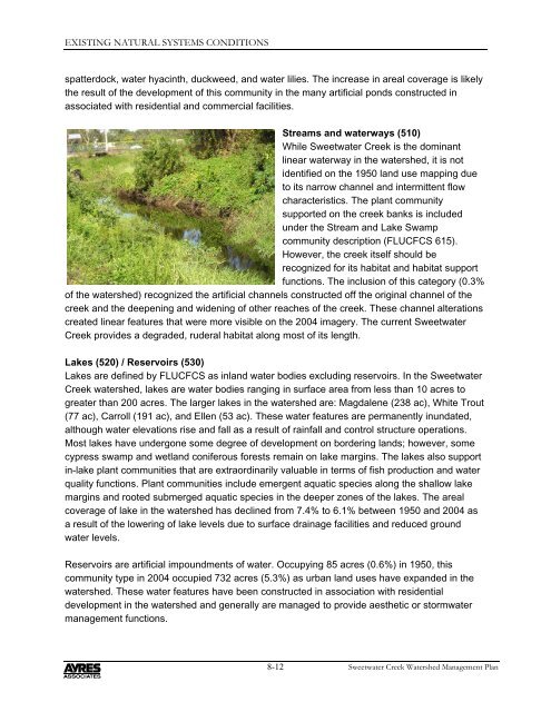
Streams and waterways (510)<br />
While <strong>Sweetwater</strong> <strong>Creek</strong> is the dominant<br />
linear waterway in the watershed, it is not<br />
identified on the 1950 land use mapping due<br />
to its narrow channel and intermittent flow<br />
characteristics. The plant community<br />
supported on the creek banks is included<br />
under the Stream and Lake Swamp<br />
community description (FLUCFCS 615).<br />
However, the creek itself should be<br />
recognized for its habitat and habitat support<br />
functions. The inclusion of this category (0.3%<br />
of the watershed) recognized the artificial channels constructed off the original channel of the<br />
creek and the deepening and widening of other reaches of the creek. These channel alterations<br />
created linear features that were more visible on the 2004 imagery. The current <strong>Sweetwater</strong><br />
<strong>Creek</strong> provides a degraded, ruderal habitat along most of its length.<br />
Lakes (520) / Reservoirs (530)<br />
Lakes are defined by FLUCFCS as inland water bodies excluding reservoirs. In the <strong>Sweetwater</strong><br />
<strong>Creek</strong> watershed, lakes are water bodies ranging in surface area from less than 10 acres to<br />
greater than 200 acres. The larger lakes in the watershed are: Magdalene (238 ac), White Trout<br />
(77 ac), Carroll (191 ac), and Ellen (53 ac). These water features are permanently inundated,<br />
although water elevations rise and fall as a result of rainfall and control structure operations.<br />
Most lakes have undergone some degree of development on bordering lands; however, some<br />
cypress swamp and wetland coniferous forests remain on lake margins. The lakes also support<br />
in-lake plant communities that are extraordinarily valuable in terms of fish production and water<br />
quality functions. <strong>Plan</strong>t communities include emergent aquatic species along the shallow lake<br />
margins and rooted submerged aquatic species in the deeper zones of the lakes. The areal<br />
coverage of lake in the watershed has declined from 7.4% to 6.1% between 1950 and 2004 as<br />
a result of the lowering of lake levels due to surface drainage facilities and reduced ground<br />
water levels.<br />
Reservoirs are artificial impoundments of water. Occupying 85 acres (0.6%) in 1950, this<br />
community type in 2004 occupied 732 acres (5.3%) as urban land uses have expanded in the<br />
watershed. These water features have been constructed in association with residential<br />
development in the watershed and generally are managed to provide aesthetic or stormwater<br />
management functions.<br />
8-12<br />
<strong>Sweetwater</strong> <strong>Creek</strong> <strong>Watershed</strong> Management <strong>Plan</strong>