URBAN DESIGN/PLACEMAkING - Renaissance Planning Group
URBAN DESIGN/PLACEMAkING - Renaissance Planning Group
URBAN DESIGN/PLACEMAkING - Renaissance Planning Group

Create successful ePaper yourself
Turn your PDF publications into a flip-book with our unique Google optimized e-Paper software.
Urban design/placemaking<br />
PHILOSOPHY & APPROACH<br />
The physical design of the built environment is fundamental to all projects at <strong>Renaissance</strong>. Through integrated, collaborative<br />
studios, <strong>Renaissance</strong> brings together architects, urban planners, landscape architects, and engineers to shape the built<br />
environment for a range of communities and clients. For the planners and designers at <strong>Renaissance</strong>, urban design is a creative<br />
expression of a spatial quality that makes vibrant places. Master and redevelopment plans are becoming increasingly<br />
important to the long-term vitality and success of communities and <strong>Renaissance</strong> provides an integrated approach to creating<br />
vibrant, sustainable places of community.<br />
SIGNATURE PROJECTS<br />
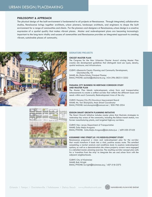
Crozet Master Plan<br />
The Congress for the New Urbanism Charter Award winning Master Plan<br />
creates site development guidelines that distinguish land use types, density,<br />
spatial enclosure, and infrastructure.<br />
CLIENT: Albemarle County <strong>Planning</strong> and Community Development,<br />
Charlottesville, VA<br />
NAME: Ms. Elaine Echols, Principal Planner<br />
EMAIL/PHONE: eechols@albemarle.org /434-296-5823 X 3252<br />
Panama City Business 98 Heritage Corridor Study<br />
and Master Plan<br />
The Master Plan blends redevelopment, urban form and transportation<br />
enhancements to create a unified corridor that reflects the different issues and<br />
needs within each Community Redevelopment Area of the city.<br />
CLIENT: Panama City (FL) Downtown Improvement Board<br />
NAME: Ms. Toni Shamplain, Main Street Coordinator<br />
EMAIL/PHONE: toni.shamplain@comcast.net / 850-785-2554<br />
Edison Smart Growth <strong>Planning</strong> Initiative<br />
The Smart Growth Initiative includes master plans that illustrate strategies to<br />
redevelop key areas of the community, including the Edison transit station, two<br />
former manufacturing plants, and targeted highway corridors.<br />
CLIENT: New Jersey Department of Transportation<br />
NAME: Zoila Mejia-Aragona<br />
EMAIL/PHONE: Zoila.Mejia-Aragona@dot.state.nj.us / 609-530-37435<br />
Kissimmee Vine Street\US 192 Redevelopment Study<br />
<strong>Renaissance</strong> prepared a vision and redevelopment plan for the corridor<br />
that would transform it back into a vital, positive access route. This entailed<br />
completing a market analysis and conditions study to explore redevelopment<br />
options, as well as a demonstration site where property owners were engaged<br />
in a detailed master planning exercise. The resulting corridor concept plan calls<br />
for a ‘transition from the strip’ to integrate the use and urban form with the<br />
adjacent neighborhoods.<br />
CLIENT: City of Kissimmee<br />
NAME: Bob Wright<br />
EMAIL/PHONE: bwright@kissimmee.org / 407-518-2373<br />
Orlando I Tampa I Charlottesville I Tallahassee I Delray Beach<br />
www.citiesthatwork.com
Scenario planning/visioning<br />
PHILOSOPHY & APPROACH<br />
Visioning is a process designed to help communities articulate long term expectations for quality of life. A vision is not a plan,<br />
but rather it provides a framework for the creation of plans and policies geared towards implementing specific elements of<br />
the vision. From preferences in urban form, to environmental preservation, to economic development, to mobility strategies,<br />
<strong>Renaissance</strong> understand the value community-driven visions have in helping policy-makers set priorities and coordinate efforts<br />
across a wide spectrum of issues. We believe visioning works best based upon a strong public engagement process where<br />
varied interests and constituencies are represented.<br />
SIGNATURE PROJECTS<br />
COUNTYWIDE VISIONING AND PLANNING PROCESS,<br />
ALACHUA COUNTY, FL<br />
<strong>Renaissance</strong> led a countywide visioning effort for Alachua County and its<br />
nine municipalities. The effort resulted in the creation of a countywide<br />
conceptual vision which articulated land use and development patterns<br />
for the unincorporated areas of the County. The visioning effort involved<br />
extensive public outreach to maintain the natural and rural character of<br />
Alachua County, while directing new growth into existing municipal centers.<br />
CLIENT: Countywide Visioning and <strong>Planning</strong> Committee (CVPC)<br />
NAME: Randall Reid, County Manager<br />
EMAIL/PHONE: rhr@alachuacounty.us / 352-374-5204<br />
Martin-St. Lucie Regional Transportation Plan<br />
<strong>Renaissance</strong> prepared a two-county long range regional transportation<br />
plan for the Metropolitan <strong>Planning</strong> Organizations (MPOs) that included an<br />
extensive scenario planning and visioning process. The result included the<br />
joint MPO adoption of a new transportation vision known as the Western<br />
Parkway scenario.<br />
CLIENT: Martin and St. Lucie MPOs<br />
NAME: Lois Bush, FDOT District 4<br />
EMAIL/PHONE: lois.bush@dot.state.fl.us / 954-777-4654<br />
Binghamton, NY Transportation for Tomorrow<br />
<strong>Renaissance</strong> led this visioning and scenario-planning process dubbed<br />
“Transportation for Tomorrow – Placemaking for Prosperity.” The<br />
process culminated in a preferred scenario for transportation, land use,<br />
and economic development, and earned a 2006 National Award for<br />
Outstanding Technical Merit from the Association of Metropolitan <strong>Planning</strong><br />
Organizations and an Honorable Mention from the 2006 FHWA/FTA<br />
Transportation <strong>Planning</strong> Excellence Awards Program (TPEA).<br />
CLIENT: Binghamton Metropolitan Transportation Study<br />
NAME: Steven Gayle, Executive Director<br />
EMAIL/PHONE: Sgayle@Co.Broome.Ny.Us / 607-778-2443<br />
MCCLENNAN COUNTY SCENARIO STUDY WACO, TX<br />
<strong>Renaissance</strong> worked with a team of consultants to create a countywide<br />
transportation and land use vision plan for the Waco, Texas Metropolitan<br />
<strong>Planning</strong> Organization (MPO). The four-step process blended technical<br />
analysis with community input in an iterative manner, including four major<br />
phases: articulating local values & priorities; imagining alternative futures;<br />
evaluating scenarios; and envisioning a preferred future. The final vision<br />
plan outlines transportation investments and land development policies in<br />
support of the preferred scenario. The MPO will use the vision plan to<br />
guide the upcoming long-range transportation plan update and work with<br />
local communities on implementing recommended policies and strategies.<br />
CLIENT: Waco Metropolitan <strong>Planning</strong> Organization<br />
NAME: Christopher Evilia, AICP, Executive Director<br />
EMAIL/PHONE: cevilia@ci.waco.tx.us / 254-750-5666<br />
Orlando I Tampa I Charlottesville I Tallahassee I Delray Beach<br />
www.citiesthatwork.com
transportation planning and engineering<br />
PHILOSOPHY & APPROACH<br />
<strong>Renaissance</strong> <strong>Planning</strong> <strong>Group</strong> provides the full range of transportation planning studies and traffic engineering services.<br />
<strong>Renaissance</strong> serves MPOs, DOTs, localities, and institutional clients on a wide range of projects, including development of<br />
long range transportation plans, traffic demand and operations modeling, corridor plans, traffic impact analyses, and freight<br />
movement planning. We are skilled in the application of Florida’s Efficient Transportation Decision Making process and the<br />
Environmental Screening Tool. In the conduct of these studies, <strong>Renaissance</strong> integrates its expertise with land use planning and<br />
urban design principles to ensure that the transportation plans are practical and support community objectives. <strong>Renaissance</strong><br />
project staff includes professional engineers and certified planners who are knowledgeable of AASHTO, ITE, NCHRP and<br />
TRB standards, recommended practices and latest research.<br />
SIGNATURE PROJECTS<br />
Liberty University Campus Growth Traffic Analysis<br />
<strong>Renaissance</strong> conducted a transportation study of the Liberty University (LU)<br />
campus for their growth plan from 10,000 to 15,000 on-campus students.<br />
The study addressed the addition of new roadways, dorms, classroom<br />
space, and related facilities relative to the multimodal needs of the campus.<br />
Recommendations ranged from additional sidewalk connections, transit routing,<br />
new roadways, and intersection improvements.<br />
CLIENT: Liberty University<br />
NAME: Lee Beaumont<br />
EMAIL/PHONE: lbeaumont@liberty.edu / 434-841-0642<br />
Sarasota/Manatee 2030 Long Range Transportation Plan<br />
<strong>Renaissance</strong> led this LRTP update in 2004-05 to guide multimodal<br />
transportation decision-making for this rapidly growing two-county area<br />
located at the southern edge of Tampa Bay. The study included evaluating<br />
alternative land use and transportation scenarios, implementing an extensive<br />
public participation program, and identifying needs and financially feasible<br />
transportation projects.<br />
CLIENT: Sarasota/Manatee Metropolitan <strong>Planning</strong> Organization<br />
NAME: Mike Maholtz, Principal Planner<br />
EMAIL/PHONE: mmaholtz@sarasota-manateempo.org / 941-359-5772<br />
Bradenton/Palmetto Downtown Mobility Study<br />
<strong>Renaissance</strong> is working with the cities of Bradenton and Palmetto in Manatee<br />
County to evaluate short-term and long-term strategies to improve mobility<br />
within and through the two downtown areas located across from each other<br />
on the Manatee River. The study feasibility of roundabouts, lane reductions/<br />
roadway narrowing, and one-way to two-way street conversions to create more<br />
livable downtowns while managing anticipated traffic growth.<br />
Client: City of Bradenton, FL Public Works Department<br />
Name: Claude Tankersley, PE, Assistant Director<br />
Email/Phone: Claude.Tankersley@cityofbradenton.com / 941-708-6300<br />
On-call Traffic and Transportation <strong>Planning</strong> Services<br />
<strong>Renaissance</strong> serves multiple cities and counties as an extension of staff for<br />
special studies, development review and plans preparation. Examples include<br />
the cities of Ocoee, Destin, Palmetto and North Port, Florida, as well as Alachua<br />
County and Manatee County, Florida. Typical assignments have included<br />
impact fee studies, traffic operational analysis and access management plans,<br />
and corridor right-of-way preservation plans and connectivity ordinances.<br />
CLIENT: City of Ocoee, FL<br />
NAME: Russ Wagner, AICP, Community Development Director<br />
EMAIL/PHONE: rwagner@ci.ocoee.fl.us / 407-905-3100<br />
Orlando I Tampa I Charlottesville I Tallahassee I Delray Beach<br />
www.citiesthatwork.com
Comprehensive planning and development codes<br />
PHILOSOPHY & APPROACH<br />
As a firm whose strength is in integrated solutions, <strong>Renaissance</strong> uses its varied expertise in land use planning, urban design,<br />
and transportation planning to craft comprehensive plans and development codes that help communities clearly articulate<br />
their vision, define key projects and clarify expectations. With innovative and proven experience in community outreach<br />
and public participation, we work to craft plans and code that are integrated and provide useful benchmarks to achieve<br />
community goals. Our portfolio of projects includes comprehensive plans and amendments, evaluation and appraisal reports,<br />
land development codes, design guidelines, and plan reviews.<br />
SIGNATURE PROJECTS<br />
Model Policies and Land Development Regulations<br />
to Support Livable Communities<br />
Within the context of largely built-out urban county with an emphasis<br />
on redevelopment, the Pinellas County MPO recommended the creation<br />
of policies that support livable community strategies that, at a minimum,<br />
improve the built environment for transit use, bicycling and walking.<br />
<strong>Renaissance</strong> has crafted model goals, objectives, policies, and land<br />
development regulations that infuse the use of density, diversity, and<br />
design to enhance placemaking and create destinations of sustaining value.<br />
CLIENT: Pinellas County, FL Metropolitan <strong>Planning</strong> Organization<br />
NAME: Al Bartolotta<br />
EMAIL/PHONE: Abartolo@pinellas.co.fl.us / 727-464-8200<br />
Town of Oakland Comprehensive Plan<br />
<strong>Renaissance</strong> completed a rewrite of the Town’s comprehensive plan and<br />
prepared a corridor master plan for Oakland Avenue and Tubb Street at<br />
the town’s historic core. Reflecting the Town’s vision, the plan emphasizes<br />
preserving the unique Old Florida rustic charm and character of the town<br />
of 2,400. The corridor master plan includes design and streetscape to<br />
organize land uses and create a coherent, well-defined walkable center<br />
for the community.<br />
CLIENT: Town of Oakland, FL<br />
NAME: Roland Magyar<br />
EMAIL/PHONE: planning@oaktownusa.com / 407-656-1117<br />
Plan East Gainesville<br />
The purpose of the Plan East Gainesville project was to develop joint City<br />
of Gainesville and Alachua County Special Area, Land Conservation, and<br />
Transportation Plans to revitalize East Gainesville, with particular attention<br />
to the environmental, economic, neighborhood and transportation factors<br />
of proposed development in this area. <strong>Renaissance</strong> led a community design<br />
charrette and prepared an integrated plan that led to amendments to the<br />
City and County comprehensive plans, revised development regulations<br />
and strategic public-private investments.<br />
CLIENT: Gainesville, FL Urbanized Area Metropolitan<br />
Transportation <strong>Planning</strong> Organization<br />
NAME: Marlie Sanderson<br />
EMAIL/PHONE: sanderson@ncfrpc.org / 352-955-2200 x103<br />
Manatee County Connectivity Study<br />
To complement the County’s thoroughfare plan, <strong>Renaissance</strong> prepared<br />
land development regulations to improve street connectivity through the<br />
site plan review process. With proper design, improved street connectivity<br />
helps reduce the traffic volume on the thoroughfare network by dispersing<br />
traffic and encouraging non-motorized travel.<br />
CLIENT: Manatee County, FL<br />
NAME: Chris Mowbray, PE<br />
EMAIL/PHONE: chris.mowbray@mymanatee.org / 941-748-4501<br />
Orlando I Tampa I Charlottesville I Tallahassee I Delray Beach<br />
www.citiesthatwork.com
Multimodal planning and design<br />
PHILOSOPHY & APPROACH<br />
<strong>Renaissance</strong> integrates its expertise and innovative tools in transportation planning, land use planning, and urban design<br />
to develop comprehensive, multimodal strategies for communities. Multimodal planning is about more than just facilitiessuccessful<br />
multimodal planning also requires a thorough understanding and analysis of the mix and arrangement of land uses,<br />
the density of development, and the design of buildings and streetscapes. Each of these elements is an essential component<br />
of a multimodal plan, whether for a master plan, corridor study, transportation plan, comprehensive plan, or visioning<br />
exercise. With an additional emphasis on funding mechanisms, design guidelines, and other implementation strategies,<br />
<strong>Renaissance</strong> provides its clients not only with a planning framework but also with the various tools required for seeing the<br />
plan through to reality.<br />
SIGNATURE PROJECTS<br />
FPO<br />
Multimodal Transportation District <strong>Planning</strong><br />
& Implementation<br />
<strong>Renaissance</strong> has prepared plans and implementation strategies for several<br />
Multimodal Transportation Districts (MMTDs) throughout Florida. MMTDs are<br />
designed to encourage infill and redevelopment through a concurrency system<br />
focused on the provision of pedestrian-friendly, transit-oriented site designs<br />
and multimodal infrastructure development.<br />
CLIENT: Boca Raton, Destin, Kissimmee, and Tarpon Springs<br />
NAME: Jerry Mucci (City of Destin); Carmen Annunziato (City of Boca Raton)<br />
EMAIL/PHONE: jmucci@cityofdestin.com / 850-837-4242; CAnnunzi@<br />
ci.boca-raton.fl.us / 561-393-7700<br />
Northwest Fluvanna/Southwest Louisa Land Use<br />
& Transportation Study<br />
In response to growth pressure on the outskirts of the Charlottesville, Virginia<br />
region, <strong>Renaissance</strong> completed a scenario planning process to evaluate the<br />
impacts of future growth on transportation, community design, and rural<br />
preservation. <strong>Renaissance</strong> provided recommendations and implementation<br />
strategies for increasing mobility options within the established communities<br />
and on the key corridors linking each community.<br />
CLIENT: Thomas Jefferson <strong>Planning</strong> District Commission<br />
NAME: Harrison Rue<br />
EMAIL/PHONE: hrue@tjpdc.org / 434-979-7310<br />
Panama City Business 98 Heritage Corridor STUDY<br />
<strong>Renaissance</strong> prepared a 7-mile Corridor Master Plan for US Business 98 through<br />
downtown Panama City, including four designated Community Redevelopment<br />
Areas (CRA), with the intent of creating a more livable, vibrant, and attractive<br />
corridor. The Master Plan reflects the different issues and needs within each<br />
CRA, with tailored recommendations for pedestrian, bicycle, and vehicle<br />
accessibility and safety; corridor aesthetics; historic assets; economic vitality;<br />
utilities; and the overall character of the corridor.<br />
CLIENT: Panama City Downtown Improvement Board<br />
NAME: Toni Shamplain<br />
EMAIL/PHONE: toni.shamplain@comcast.net / 850-785-2554<br />
Tallahassee-Leon County Bicycle & Pedestrian Master Plan<br />
<strong>Renaissance</strong> developed a Countywide Bicycle and Pedestrian Master Plan for<br />
the Tallahassee-Leon County MPO (since expanded and renamed), consisting of<br />
a 2025 Needs and Cost Feasible Plan that identified facility improvements and<br />
recommendations for education, enforcement, and encouragement programs<br />
and policies. The plan included a set of design guidelines with minimum<br />
standards, best practices, and preferred treatments to support walking and<br />
bicycling.<br />
CLIENT: Capital Region Transportation <strong>Planning</strong> Agency<br />
NAME: Jack Kostrzewa<br />
EMAIL/PHONE: kostrzej@talgov.com / 850-891-8622<br />
Orlando I Tampa I Charlottesville I Tallahassee I Delray Beach<br />
www.citiesthatwork.com
A CorPlan overview<br />
Introduction<br />
CorPlan is a scenario planning model that estimates land development potential using prototypical community elements as<br />
its building blocks. It uses ARCVIEW© geographic information system (GIS) software, and the associated databases can<br />
be linked to Excel spreadsheets. The development of CorPlan was funded by a Federal Highway Administration (FHWA)<br />
Transportation and Community and System Preservation (TCSP) grant for the Eastern Area <strong>Planning</strong> Initiative conducted by<br />
the Thomas Jefferson <strong>Planning</strong> District Commission for the Charlottesville, Virginia region. The software has since been used<br />
to support planning work in a number of large and small communities throughout the United States.<br />
Model Structure<br />
CorPlan relies on prototypical community definitions (community elements) to estimate land development potential and how<br />
that potential translates into the location of households and jobs. Each community element represents the development and<br />
infrastructure characteristics of a 31-acre area – the area of a circle with a quarter mile diameter. The quarter mile scale<br />
encompasses the maximum comfortable walking distance to transit for typical Americans.<br />
Each element reflects a unique existing or planned<br />
development pattern, such as urban downtowns,<br />
suburban retail areas, and village centers. The community<br />
elements are illustrated with a plan graphic and photos<br />
that convey their look and feel. Through workshops with<br />
community members and planners, enhanced community<br />
elements can be developed to represent characteristics<br />
of desired future development patterns. Each element<br />
is also associated with land use, infrastructure and<br />
socioeconomic data in order to estimate its development<br />
potential.<br />
Estimating Future Land Use Potential<br />
Users estimate land development potential in CorPlan by<br />
assigning one of the community elements to a subarea,<br />
such as collections of traffic zones or Census blocks<br />
that define boundaries for communities within the study<br />
area. CorPlan multiplies the land use, infrastructure and<br />
socioeconomic characteristics of the selected element by the total useable land in the subarea. Useable land includes<br />
both developed and vacant land suitable for development. The model sums the development potential for all subareas to<br />
estimate the total development potential for the study area.<br />
Developing and Testing Scenarios<br />
Users can quickly test alternative development scenarios by<br />
assigning community elements in different patterns, by adjusting<br />
the information in the community element inventories, and/or by<br />
creating new community elements to reflect community design<br />
characteristics that are not reflected in the existing inventory. For<br />
example, planners can try a scenario that assumes the continuation<br />
of a suburban retail pattern (shopping centers) along a major<br />
arterial corridor to determine how much land would be needed<br />
to extend to meet future retail employment forecasts at the<br />
existing scale and density. They can easily compare this to alternative scenarios<br />
that assume the creation of urban or enhanced suburban mixed use community<br />
centers along the corridor, which typically consume less land than the continuation<br />
of existing low-density patterns.<br />
Connecting with Other <strong>Planning</strong> Tools<br />
CorPlan makes a direct connection between land development patterns and<br />
socioeconomic characteristics. As alternative land use scenarios are tested the<br />
model automatically generates socioeconomic inputs for travel demand models.<br />
The unique travel parameters for each community element are incorporated into<br />
travel demand models so they can better reflect the influence of development<br />
patterns on travel characteristics.<br />
CorPlan connects regional land development patterns with site-specific development guidelines. The regional land use map<br />
identifies community element boundaries, and each assigned element has very specific land use, building and infrastructure<br />
guidelines. Some localities have used the community elements as a resource to help guide the development of local design<br />
standards. CorPlan can also generate projected fiscal impacts of alternative scenarios, and a module to assess multi-modal<br />
accessibility is under development. Another future enhancement to CorPlan is connecting with environmental and community<br />
assessment tools. The detailed information available for each community element is well suited for these tools and enables<br />
users to quickly assess the impacts of alternative development patterns over large areas.<br />
For more information:<br />
Chris Sinclair, AICP<br />
President, <strong>Renaissance</strong> <strong>Planning</strong> <strong>Group</strong><br />
407- 487-0061x111 / csinclair@CitiesThatWork.com<br />
Orlando I Tampa I Charlottesville I Tallahassee I Delray Beach<br />
www.citiesthatwork.com
Transit <strong>Planning</strong> and Operations<br />
PHILOSOPHY & APPROACH<br />
<strong>Renaissance</strong> understands the essential link between urban form and effective transit operations, where access to service<br />
and ridership are enhanced through principles of urban design and efficient service delivery. We believe that transit<br />
functions well as a viable travel choice to improve mobility and access when integrated into community design and an<br />
overall plan for corridor investment, economic opportunity and development performance standards. Our work has entailed<br />
transit operations and service plans, market research, countywide and regional system plans, funding, governance and<br />
administrative structure analysis, and the planning and design of transit-oriented development. We deliver these services by<br />
working in partnership with transit providers, stakeholders and the community to provide innovative, responsive and fiscallyresponsible<br />
solutions.<br />
SIGNATURE PROJECTS<br />
Strategic Regional Transportation Initiative<br />
When the Tampa Bay Partnership got serious about its regional transportation<br />
initiative to improve mobility for the 8-county West Central Florida region,<br />
they turned to <strong>Renaissance</strong> to research best practices and provide guidance<br />
for a major expansion of transit service. <strong>Renaissance</strong> provided research and<br />
policy analysis to help create the Tampa Bay Area Regional Transportation<br />
Authority (TBARTA) in 2007, and continues to work on defining a regional<br />
funding strategy.<br />
CLIENT: Tampa Bay Partnership<br />
NAME: Stuart Rogel, CEO<br />
EMAIL/PHONE: srogel@tampabay.org / 813-878-2208<br />
Public Transportation System Analysis<br />
<strong>Renaissance</strong> prepared a two-county long range regional transit plan for the<br />
MPO in 2002 to define a service plan focused on major corridors and hubs<br />
to improve system efficiency, effectiveness and address mobility challenges<br />
in this fast-growing region on Florida’s southwest coast. Following adoption,<br />
subsequent work included a Latent Demand Analysis for the US 41 Corridor<br />
and a regional governance strategy to consolidate operations of the two<br />
county-based transit agencies.<br />
CLIENT: Sarasota/Manatee MPO<br />
NAME: Mike Howe, Executive Director<br />
EMAIL/PHONE: mhowe@sarasota-manateempo.org / 941-359-5772<br />
Transit Development Plan and Transportation<br />
Disadvantaged Service Plan<br />
<strong>Renaissance</strong> prepared a major update of the Brevard TDP and TDSP in 2007,<br />
building upon our prior market research for SCAT in 2004. The project entailed<br />
a peer review, use of the T-BEST model for ridership estimation, preparation<br />
of a 10-year vision and 5-year implementation plan, and extensive public<br />
participation, consistent with Florida’s TDP rule and TDSP requirements.<br />
CLIENT: Brevard County MPO and Space Coast Area Transit<br />
NAME: Jim Liesenfelt, Director<br />
EMAIL/PHONE: jim@ridescat.com / 321-635-7815<br />
Hillsborough MPO Transit Study<br />
Facing rapid growth and extensive traffic congestion, the Hillsborough County<br />
MPO engaged <strong>Renaissance</strong> to lead a scenario planning process to define a<br />
major transit investment strategy as the transit element of the Long Range<br />
Transportation Plan. Work entailed extensive community outreach, defining<br />
and evaluating transit-land use scenarios, and crafting a countywide vision and<br />
operational plan for regional and local transit solutions, and priority corridors<br />
for investment. This fits within the regional context of the Tampa Bay Area<br />
Regional Transportation Authority.<br />
CLIENT: Hillsborough County MPO (Tampa, FL)<br />
NAME: Lucie Ayer, AICP, Executive Director<br />
EMAIL/PHONE: ayerl@plancom.org / 813-272-5940<br />
Orlando I Tampa I Charlottesville I Tallahassee I Delray Beach<br />
www.citiesthatwork.com