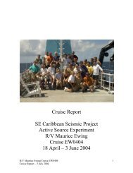
Cruise Report - Marine Geoscience Data System
Cruise Report - Marine Geoscience Data System
Cruise Report - Marine Geoscience Data System

You also want an ePaper? Increase the reach of your titles
YUMPU automatically turns print PDFs into web optimized ePapers that Google loves.
Lamont-Doherty Geological Observatory Palisades, N.Y. 10964<br />
of Columbia University<br />
Cable: LAMONT, Palisades, New York State<br />
Telephone Code 914, Elmwood 9-2900<br />
TWX: 710-576-2653<br />
CRUISE REPORT<br />
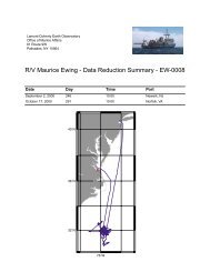
Ship Name: ROBERT D. CONRAD <strong>Cruise</strong> No: 21-06<br />
Departure: March 3, 1978 from Buenos Aires, Argentina<br />
Date<br />
Port<br />
Arrival: April 4, 1978 at Punta Arenas, Chile<br />
Date<br />
Port<br />
Days at Sea: 32 Days Foreign Port: 4<br />
No. of days in arrival port<br />
Area of Operation: Falkland Plateau<br />
Program Description:<br />
A multichannel seismic reflection study of the Falkland Plateau, Falkland<br />
Trough, and North Scotia Ridge (NSF Grant OCE 77-25992)<br />
Participants: (All L-DGO unless otherwise specified)<br />
Ludwig, W.J.<br />
Robinson, W.<br />
Gutierrez, C.<br />
Iltzsche, M.<br />
Sindt, J.<br />
Robertson, W.<br />
Rottier, R.<br />
Hutchinson, D.<br />
Mouzo, F.<br />
Chief Scientist<br />
Electronics Engineer<br />
E.T.<br />
Compressor/Air Gun Technician<br />
Compressor/Air Gun Technician<br />
E.T.<br />
E.T.<br />
E.T.<br />
<strong>Marine</strong> Geologist, Servicio Hidrografia<br />
Naval, Argentina<br />
All inquiries regarding cruise should be made to the chief scientist.
1<br />
<strong>Cruise</strong> Narrative: RC 21-06<br />
ROBERT D. CONRAD departed Buenos Aires on March 3, 1978<br />
after a 13-day delay caused by late arrival of air freight<br />
(see attachments) and arrived Punta Arenas afternoon of 4<br />
April 1978, upon completion of a 32-day cruise leg. The<br />
Lamont 24-channel seismic reflection (MCS) system and sonobuoy<br />
reflection/refraction system were used to investigate<br />
the structural relationship of the Falkland Plateau, Falkland<br />
Trough, North Scotia Ridge, and Scotia Sea within the framework<br />
of plate tectonics. The objectives were to delineate<br />
depositional and erosion patterns and from them reconstruct<br />
the depositional and tectonic history of the area; distinguish<br />
acoustic basement and true crystalline basement of the Falkland<br />
Plateau and, thus, correlate structure of the plateau with<br />
that of the Agulhas shelf of South Africa; determine the velocity<br />
structure across the continent-ocean juncture of the Falkland<br />
Plateau and Falkland Trough; determine the structure of the<br />
North Scotia Ridge; and determine the structure and pattern and<br />
intensity of folding and faulting in the area of a supposed<br />
extinct subduction zone which presently is manifested by the<br />
Falkland Trough. The locations of the multichannel lines were<br />
chosen to tie existing L-DGO lines of single-channel reflection<br />
and refraction measurements, to avoid duplication of effort<br />
with recently acquired Industry MCS lines in the Falkland
2<br />
Islands vicinity, and to complement an L-DGO proposal for<br />
geological mapping in the offshore portion of the Magellanes<br />
Basin. Approximately 2500 miles of multichannel CDP reflection<br />
data were recorded (Figure 1); in addition, 55 sonobuoy<br />
reflection and refraction profiles were recorded along the<br />
survey route to provide information on velocity structure.<br />
Sediment Attenuation Study<br />
Enroute to the Falkland Plateau, a few hours were spent<br />
in the vicinity of 40°S to make a seismic refraction profile<br />
in the Colorado Basin through use of sonobuoys and the largevolume<br />
air gun system. Sonobuoy records from this and other<br />
areas develop strong curved path multiples, which are ideal<br />
for the estimation of attenuation losses. The data from three<br />
non-AGC commercial sonobuoys were recorded digitally on the<br />
DFS IV. One buoy may have successfully recorded the desired<br />
information.<br />
KCS Streamer Ballasting<br />
Streamer reballasting in the vicinity of 46°S required<br />
27 hours to complete. Approximately 300 lbs of lead weight<br />
were stripped from the streamer to enable it to be towed at a<br />
depth of 45-50 feet below the surface. Our final distribution<br />
of weights consisted of one (1) lb weights evenly distributed<br />
along the tail stretch section and active sections 1-5; two
3<br />
(2) lb weights evenly distributed along active sections 6-24<br />
and the two front-end stretch sections. The streamer is still<br />
negatively buoyant.<br />
Prior to the next MGS leg of CONRAD it will be necessary<br />
to:<br />
a) replace head stretch section<br />
b) replace section 20 (shark bite damage)<br />
c) add weight to section 16 and tail section<br />
d) subtract weight from sections 14 and 15<br />
e) add weight to head stretch section.<br />
MCS Recording and Sound Source <strong>System</strong>s<br />
The DFS IV and compressor-air gun system performed very<br />
well, largely due to the diligent efforts of Bill Robinson,<br />
John Sindt and Martin Iltzsche. 4-450 cu.in. air guns fired<br />
at 2000 psi were operated 95% time; the seismic coverage is<br />
100%.<br />
Successful operation of the MCS system in the future requires<br />
that a) additional people be trained (hired) in the<br />
maintenance and use of the DFS IV and compressor-air gun systems,<br />
b) there be an emergency power supply to drive the storage reel<br />
for the MCS streamer in the event of a pump failure, and c)<br />
Notice to <strong>Marine</strong>rs of the intent to conduct MCS measurements<br />
be published one or two months in advance of the operation.
4<br />
The notice should give area, time, description of ship, call<br />
signs and indicate ship will be towing streamer 2400 m long,<br />
30-50 feet below the surface; request do not approach within<br />
10 miles.<br />
Gravity, Magnetics, PDR, and Single Channel Seismics<br />
During RC21-06, all of the ills encountered in the previous<br />
leg (M. Langseth, Ch. Sci.) were corrected except for<br />
gravity. Upon arrival in B.A., I was informed for the first<br />
time that the gravimeter table had not functioned properly<br />
since Rio. We later concluded at sea that the trouble was due<br />
to seized bearings. This was reported to L-DGO; a factory<br />
trained technician and replacement bearings were subsequently<br />
flown to Punta Arenas where the problem was corrected.<br />
Core Winch and Hydro Winch<br />
No station work was done during this leg. Infrequent use<br />
of the winches will result in poor maintenance unless someone<br />
is assigned full time to care for them. Bob Crimmins, Core<br />
Bosun, departed the ship in B.A. The replacement Core Bosun<br />
served mostly as a wiper in the engine room. Hence, there is<br />
no one at present trained to properly operate the core winch<br />
and set up core pipe. There is the possibility that rough<br />
handling of the core winch (bottoming-out the accumulator for
5<br />
long periods of time) during the Vema Fracture Zone dredging<br />
operations resulted in failure of the planetary gears early<br />
in the following leg.<br />
Weather<br />
Sea conditions during the leg ranged from moderate to<br />
gale force. Frequent heavy surging of the ship resulted in<br />
heaving of the leader and noise on the head section.<br />
Numerous icebergs were encountered at 52°S, 40°30'W.<br />
Bergs, growlers and cubes became so concentrated at 52°30’S,<br />
41°W that it was necessary to abandon the line and head northwestward<br />
(see attachment for information on ice coordinates<br />
and forecasting).<br />
Highlights of the Monitor Records<br />
1. True (crystalline) basement was traced everywhere beneath<br />
the plateau and trough.<br />
2. Folding and faulting of sedimentary horizons are observed<br />
over basement relief, basement is often block faulted.<br />
3. Major pinch-outs of sedimentary layers occur on the<br />
plateau.<br />
4. A large open-ended sub basin exists just north of M.<br />
Ewing Bank at the elge of the plateau.<br />
5. Basement was traced 25 miles beneath the toe of the
6<br />
North Scotia Ridge to a location where the dip (on the seismic<br />
records) becomes near-vertical.<br />
6. The northern side slope of Burdwood Bank consists of<br />
highly deformed (folded) sediments.<br />
7. The Malvinas Basin is separated from the Falkland<br />
Plateau basin by a high presumably trending southward from<br />
Cape Meredith, Falkland Islands.<br />
William J. Ludwig
13-Day Delay of R/V CONRAD in Buenos Aires<br />
For what it is worth, the following is a "Monday Morning<br />
Quarterback" assessment of the cause of the big delay in B.A.<br />
1. Failure to ascertain the condition of air cargo traffic<br />
to South America. Apparently, the Longshoremen's strike and<br />
February 6 snow storm had caused a major backup of air cargo<br />
in New York.<br />
2. Failure to close the airfreight shipment on schedule.<br />
The shipment was sent to a broker only a few days before<br />
conrad's arrival in B.A. The GBL is dated February 7.<br />
3. Failure to obtain a direct cargo flight to B.A. Both<br />
Braniff and Pan Am have direct flights. For some reason, the<br />
cargo had to be transferred to a non-U.S. carrier in Sao Paulo<br />
causing additional delay in arrival at B.A. Furthermore, the<br />
non-U.S, carrier was not advised of the procedure for payment;<br />
hence, they would not immediately release the cargo.<br />
4. Failure to consign the freight as instructed. Manuel<br />
Schkulnik's lengthy telex of January 13 (copy supplied to L-DGO<br />
Shipping) advises that we consign material to the ship in care<br />
of the Argentine Hydrographic Service in order to clear Customs<br />
rapidly. The shipment was consigned instead to the Ship’s Agent.<br />
Furthermore, no copies of the shipping documents were air mailed<br />
to the Ship's Agent and to Schkulnik.
COLUMBIA UNIVERSITY<br />
INTERDEPARTMENT MEMORANDUM<br />
R/V CONRAD<br />
Buenos Aires, Argentina<br />
Date: 2 March, 1978<br />
To Chief Scientists of Research Vessels<br />
Subject: Customs Requirements, Port Regulations and Air Freight<br />
Shipments: Know before ye go<br />
Before joining a research vessel in a foreign port, or immediately upon<br />
your arrival, you are advised to familiarize yourself with Customs and Port<br />
regulations. A little time spent in preparation may save you considerable time<br />
and grief.<br />
1. Bureaucracy reigns in customs. Detailed documentation is very important.<br />
All airway bills of lading (AWB) should be accompanied for cus- toms purposes<br />
by a detailed packing list and the declared value. Listing an item(s) as simply<br />
"electronic equipment" may cause trouble. Be specific; list every nut and<br />
bolt.<br />
The nature of the shipment should be clearly marked on the boxes as<br />
follows:<br />
Ship Spare Parts<br />
Ship Scientific Material<br />
(name of port) in Transit or (name of port) in Transit<br />
Only items that fit into these two categories will be cleared by Customs.<br />
Including personal items in the shipment usually results in seizure and considerable<br />
delay in port.<br />
If you hand-carry "last minute" spare parts to the ship, be prepared for<br />
serious difficulty if not confiscation and loss of the material. You may have<br />
to pay a duty of 100-150% of the appraised value, if lucky. Confiscated material<br />
will not be placed aboard your connecting flight. Remember, you need<br />
an import license to bring merchandise or industrial parts into a country. Have<br />
all parts shipped air freight consigned to the ship and document, as indicated<br />
above. Request shipment on a direct flight to avoid airline transfer and delay.<br />
If you must hand-carry parts or equipment, arrange with the Captain to have a<br />
ship's agent or Customs broker meet you at the airport. Supply the Captain<br />
with detailed information so that documentation can be obtained in advance of<br />
your arrival. My advice is simply, avoid hand carrying parts and equipment; ship<br />
via direct air freight even if it may mean an extra day in port. Consult<br />
with the Director's office.<br />
2. Most ports are under some type of police or military control. You must<br />
have a shore pass or stamped passport to enter most ports. Visit the ship's<br />
agent upon arrival. Your friends and invited guests may also require a pass.<br />
Unauthorized persons in a port are subject to arrest.
COLUMBIA UNIVERSITY<br />
INTERDEPARTMENT MEMORANDUM<br />
To<br />
Subject: .<br />
Date: .<br />
Inviting the local repair man to repair an item of scientific or ship's<br />
equipment may not be an easy task. Repair men also require a pass; all<br />
of their tools may have to be inventoried by Customs. To most repair men,<br />
the ship's business may not be worth the effort it takes to come on board.<br />
More Tips:<br />
1. When on board ship, give the Captain a list of items to be shipped<br />
back to Lamont so that he can manifest and declare them before entering port.<br />
Provide dimensions and weight of each box and a detailed packing liat. Last<br />
minute items are usually impossible to get through Customs. The Ship's Agent<br />
will usually ignore non-manifested items; he knows the difficulty that he will<br />
have with Customs.<br />
2. L-DGO Shipping distributes a notice of the name and address of the<br />
Ship's Agent and the date the air freight and (or) sea freight shipment closes.<br />
It usually requires about two weeks to process and deliver air freight to the<br />
ship, provided that there is no back log of freight at the airlines (labor<br />
strikes and closure of airports due to storms usually result in severe backlogs<br />
of freight}. Check with Shipping on the conditions of freight traffic to the<br />
port-of-call and check with them again to ascertain if the shipment has indeed<br />
been closed on the announced date and is not being held up by someone awaiting<br />
last minute items for inclusion. Last minute items should be sent separately, as<br />
indicated above.<br />
Check with L-DGO Shipping as to the intended routing of the shipment.<br />
Request a direct flight, if available, to avoid delay and complications. Know<br />
ye all that non-U. S. carriers know little or care little for shipments covered<br />
by a U.S. Government Bill of Lading. The terms of a GBL specify that the<br />
carrier submit a bill for payment after receipt of the cargo at its<br />
destination. Payment often takes months and involves considerable paper work.<br />
If your shipment is transferred to a non-U.S. carrier somewhere enroute, the<br />
carrier might insist on cash on delivery or a guarantee of payment before<br />
releasing the shipment. Your contract/grant will have to absorb the C.O.D.<br />
charge if you are forced to pay or if the GBL does not permit transfers.
COLUMBIA UNIVERSITY<br />
INTERDEPARTMENT MEMORANDUM<br />
To<br />
Subject: .<br />
Date: .<br />
Check with L-DGO Shipping a few days before departure. Obtain and handcarry<br />
to the ship copies of all documents with AWB numbers. Ascertain if the<br />
shipment has indeed departed on the flight indicated; it might still be sitting<br />
in a cargo warehouse at the airport awaiting its turn. Request airline<br />
confirmation of departure of the shipment, via TWX if possible. Confirmation<br />
via telephone will not provide you with a document; besides, a busy clerk may<br />
give erroneous and(or) misleading information.<br />
William J. Ludwig<br />
Scientific Prog ram Coordinator for<br />
R/V Vema and R/V Conrad<br />
WJL/bh<br />
cc: H. C. Kohler, R/V Vema<br />
J. P. Olander, R/V Conrad<br />
R. Gerard, <strong>Marine</strong> Supt.<br />
T. Eberhard, L-DGO Shipping
COLUMBIA UNIVERSITY<br />
INTER DEPARTMENT MEMORANDUM<br />
To: Chief Scientists of Research Vessels<br />
Subjact: Ice Conditions in High Latitudes<br />
Date: April 12, 1978<br />
Before joining a research vessel to conduct geological/<br />
geophysical studies in an area where there may be navigational<br />
difficulty due to icebergs, you are advised to send a copy of<br />
your track chart to:<br />
Commanding Officer<br />
Fleet Weather Facility<br />
Navy Department<br />
Washington, D.C. 20575<br />
Attn: Ice Dept.<br />
and request updated ice charts for the survey area. The<br />
charts are based on interpretations of photos from satellites.<br />
Updates at sea in the South Atlantic can be provided by<br />
radio from Palmer Station, which is run by Holmes and Narver<br />
(private contractors). You can set up a communication link<br />
with them by calling 714-975-1100 ext. 2250 or 2251 and ask<br />
for Shane Williams or Dick Wallach.<br />
Further information can be obtained from LCDR Hoffman<br />
(ice forecasting) at 202-765-5975.<br />
William J. Ludwig<br />
Scientific Program Coordinator<br />
for R/V VEMA and R/V CONRAD<br />
cc: H.C. Kohler, R/V VEMA<br />
J.P. Olander, R/V CONRAD<br />
R. Gerard, <strong>Marine</strong> Supt.<br />
P.S. Stan Jacobs receives weekly reports on ice coordinates<br />
and also receives a yearly summary which is also useful.