Appendix A_Pages266to338_9MB.pdf - Ottawa Confederation Line
Appendix A_Pages266to338_9MB.pdf - Ottawa Confederation Line
Appendix A_Pages266to338_9MB.pdf - Ottawa Confederation Line

You also want an ePaper? Increase the reach of your titles
YUMPU automatically turns print PDFs into web optimized ePapers that Google loves.
©2009 Microsoft Corporation<br />
©2009 Microsoft Corporation<br />
TRANSPORTATIO N IN FORMATIO N TE WATER<br />
TRANSPORTATION INFORMATION TE WATER<br />
©2009 Microsoft Corporation<br />
©2009 Microsoft Corporation<br />
TRANSPORTATION INFORMATION TE WATER<br />
TRANSPORTATION INFORMATION TE WATER<br />
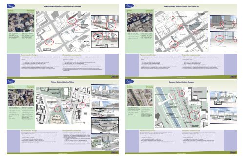
Downtown West Station / Station centre-ville ouest<br />
Downtown East Station / Station centre-ville est<br />
Station<br />
Overview<br />
Aperçu de<br />
la station<br />
Kent<br />
Place de Ville<br />
Station<br />
Overview<br />
Aperçu de<br />
la station<br />
Tunnel alignment /<br />
Tracé du tunnel<br />
Potential alternate entry /<br />
Entrée alternative potentielle<br />
Sparks<br />
Metcalfe<br />
Lyon<br />
Queen<br />
Hôtel Crowne Plaza Hotel<br />
Station entry /<br />
Entrée de la station<br />
Constitution Square<br />
Potential connection to<br />
Constitution Square /<br />
Connection potentielle<br />
au Constitution Square<br />
Station entry /<br />
Entrée de la station<br />
Queen<br />
Potential aternate entry /<br />
Entrée alternative potentielle<br />
Station entry /<br />
Entrée de la station<br />
Potential aternate entry /<br />
Entrée alternative potentielle<br />
Albert<br />
Slater<br />
Potential alternate<br />
entry at Constitution<br />
Square /<br />
Entrée alternative<br />
potentielle au<br />
Constitution Square<br />
Platform level /<br />
Niveau de la plate-forme<br />
Concourse level /<br />
Niveau de la zone de confluence<br />
Bank<br />
Albert<br />
Slater<br />
O’Connor<br />
World Exchange Plaza<br />
Station entry /<br />
Entrée de la station<br />
Potential alternate entry /<br />
Entrée alternative<br />
potentielle<br />
Potential below grade<br />
pedestrian connection /<br />
Connection piétonnière potentielle<br />
sous le niveau du sol<br />
Concourse level /<br />
Niveau de la zone de confluence<br />
Platform level /<br />
Niveau de la plate-forme<br />
• Located under Albert Street,<br />
east of Bay Street<br />
• Allows integration with future<br />
Central Public Library building<br />
• Serves existing development in<br />
west end of downtown<br />
• Située sous la rue Albert, à l'est<br />
de la rue Bay<br />
•· Permet une intégration à la future<br />
Bibliothèque publique centrale<br />
• Dessert les secteurs situés à<br />
l'extrémité ouest du centre-ville<br />
Tunnel alignment /<br />
Tracé du tunnel<br />
Constitution Square<br />
Place de Ville<br />
Potential alternate entry (by others) /<br />
Entrée alternative potentièlle (par d’autres)<br />
Station entry /<br />
Entrée de la station<br />
Albert<br />
Constitution Square<br />
• Located north of Albert Street,<br />
between Bank Street and O'Connor<br />
Street<br />
• Connects with local bus services<br />
on Bank Street<br />
• Serves existing development in<br />
central and east parts of<br />
downtown<br />
• Située au nord de la rue Albert,<br />
entre les rues Bank et O'Connor<br />
• Correspondances avec les services<br />
d'autobus locaux sur la rue Bank<br />
• Dessert les secteurs des parties<br />
centrale et est du centre-ville<br />
Sun Life Centre<br />
Station entry /<br />
Entrée de la station<br />
Potential aternate entry /<br />
Entrée alternative potentielle<br />
Minto Place<br />
Potential below grade pedestrian<br />
connection (by others) /<br />
Connection piétonnière potentielle<br />
sous le niveau du sol (par d’autres)<br />
Station entry /<br />
Entrée de la station<br />
Concourse level /<br />
Niveau de la zone<br />
de confluence<br />
Platform level /<br />
Niveau de la plate-forme<br />
Station entry /<br />
Entrée de la station<br />
Concourse level /<br />
Niveau de la zone de confluence<br />
Future Site for the<br />
<strong>Ottawa</strong> Public Library /<br />
Futur site de la Bibliothèque<br />
publique d’<strong>Ottawa</strong><br />
Recommended Design<br />
The recommended design for the Downtown West Station follows the approved “Centre Platform” design alternative, and<br />
incorporates the following major elements:<br />
• 180 m long LRT platforms, in a centre platform configuration, to accommodate 4-car trains initially and 6-car trains in<br />
the future<br />
• 2 access points from ground level:<br />
• On the south side of Albert between Bay and Lyon (Central Public Library site)<br />
• On the north side of Albert between Lyon and Kent (Place de Ville)<br />
• Elevators, escalators and stairs will be provided at each access point<br />
• An underground connection to the Constitution Square office complex could be constructed in the future, by others<br />
• Underground connections to other adjacent development sites could also be provided by others<br />
• Depth of platform is approximately 30 m below ground due to foundation depths of adjacent buildings<br />
Conception recommandée<br />
La conception recommandée pour la station centre-ville ouest est la conception approuvée “plate-forme centrale” et<br />
comprend les éléments principaux suivants :<br />
• Des plate-formes centrales TLR, d'une longueur de 180 m, pouvant initialement accueillir des trains de quatre voitures et<br />
éventuellement de six voitures<br />
• Deux points d'accès au niveau du sol :<br />
• Du côté sud d'Albert, entre Bay et Lyon (emplacement de la Bibliothèque publique centrale)<br />
• Du côté nord d'Albert, entre Lyon et Kent (Place de Ville)<br />
• Des ascenseurs, des escaliers roulants et des escaliers aux points d'accès<br />
• Une connection souterraine aux tours à bureaux de Constitution Square pourrait éventuellement être construite par<br />
d'autres intervenants<br />
• Des connections souterraines à des immeubles voisins pourraient aussi être réalisés par d’autres intervenants<br />
• La profondeur de la plate-forme est d'environ 30 m sous le niveau du sol à cause de la profondeur des fondations des<br />
immeubles voisins<br />
Recommended Design<br />
The recommended design for the Downtown East Station follows the approved “Centre Platform” design alternative, and<br />
incorporates the following major elements:<br />
• 180 m long LRT platforms, in a centre platform configuration, to accommodate 4-car trains initially and 6-car trains in<br />
the future<br />
• 2 access points from ground level:<br />
• On the north side of Albert Street, east of Bank Street<br />
• On the south side of Queen Street at O'Connor Street<br />
• Elevators, escalators and stairs will be provided at each access point<br />
• An underground connection to the World Exchange office complex could be constructed in the future, by others<br />
• An underground connection to Sparks Street could be constructed in the future, by others<br />
• Underground connections to other adjacent development sites could also be provided<br />
Conception recommandée<br />
La conception recommandée pour la station centre-ville est est la conception « plate-forme centrale» approuvée et<br />
comprend les éléments principaux suivants :<br />
• Des plate-formes centrales TLR d'une longueur de 180 m, pouvant initialement accueillir des trains de quatre voitures et<br />
éventuellement de six voitures<br />
• Deux points d'accès au niveau du sol :<br />
• du côté nord de la rue Albert, à l'est de la rue Bank<br />
• du côté sud de la rue Queen sur la rue O'Connor<br />
• Des ascenseurs, des escaliers roulants et des escaliers aux points d'accès<br />
• Une connection souterraine au World Exchange Plaza pourrait éventuellement être construit par d'autres intervenants<br />
• Un connection souterraine à la rue Sparks pourrait éventuellement être construit par d’autres intervenants<br />
• Des connections souterraines à des immeubles voisins pourraient aussi être réalisés par d’autres intervenants<br />
www.ottawa.ca/tunnel<br />
www.ottawa.ca/tunnel<br />
Rideau Station / Station Rideau<br />
Campus Station / Station Campus<br />
Station<br />
Overview<br />
Aperçu de<br />
la station<br />
Westin<br />
Hotel<br />
National Arts Centre /<br />
Centre national des Art<br />
Station<br />
Overview<br />
Aperçu de<br />
la station<br />
Wellington<br />
Sussex<br />
George<br />
Rideau<br />
Welington<br />
Fairmont Château Laurier<br />
Parliament East Block /<br />
Édifice de l’Est<br />
George<br />
Centre Rideau Centre<br />
Ridau e<br />
East concourse -<br />
potential access to<br />
Rideau Centre<br />
and The Bay /<br />
Zone de confluence<br />
est-accès potentiel<br />
au Centre Rideau et<br />
à The Bay<br />
Potential<br />
concourse level /<br />
niveau de la zone<br />
potentielle de confluence<br />
Canal<br />
Rideau<br />
Canal<br />
Government of Canada<br />
Conference Centre /<br />
Centre des conférence du<br />
gouvernement du Canada<br />
Pont Plaza Bridge<br />
Colonel By<br />
Nicholas<br />
Potential station entry /<br />
Entrée potentielle de la station<br />
Station entry /<br />
Entrée de la station<br />
University of <strong>Ottawa</strong> /<br />
Université d'<strong>Ottawa</strong><br />
Colonel By<br />
Existing Transitway to be removed /<br />
Transitway existant à être enlever<br />
Nicolas<br />
Station entry /<br />
Entrée de la station<br />
Queen<br />
Albert<br />
Elgin<br />
• Located south of Wellington Street,<br />
between <strong>Confederation</strong> Square and<br />
Sussex Drive<br />
• Provides connections to both west and<br />
east sides of Rideau Canal<br />
• Potential integration with the<br />
Government Conference Centre<br />
• Potential integration with National<br />
Capital Commission commemorative<br />
design initiative for the Rideau/Sussex<br />
intersection<br />
• Provides for connections to local and<br />
regional (STO) buses<br />
• Située au sud de la rue Wellington,<br />
entre la place de la Confédération et<br />
la promenade Sussex<br />
• Carrefour entre les côtés est et ouest<br />
du canal Rideau<br />
• Intégration potentielle avec le Centre<br />
des conférences du gouvernement<br />
• Intégration potentielle au projet de<br />
design urbain à vocation<br />
commémorative de l'intersection<br />
Rideau et Sussex de la Commission<br />
de la capitale nationale<br />
• Point de correspondance pour les<br />
autobus locaux et régionaux (STO)<br />
Sparks<br />
Queen<br />
Albert<br />
Tunnel alignment /<br />
Tracé du tunnel<br />
National War Memorial /<br />
Mémorial national de<br />
geurre du Canada<br />
Elgin<br />
Station entry /<br />
Entrée de la<br />
station<br />
National Arts Centre /<br />
Centre national des Arts<br />
Pont Plaza Bridge<br />
Government of Canada<br />
Conference Centre /<br />
Centre des conférence<br />
du gouvernement<br />
du Canada<br />
Canal Rideau Canal<br />
Potential station entry /<br />
Entrée potentielle de<br />
la station<br />
Colonel By<br />
Station entry<br />
(within Rideau<br />
Centre) /<br />
Entrée de la<br />
station (à partir<br />
du Centre<br />
Rideau)<br />
Westin Hotel<br />
The Bay<br />
Centre<br />
Rideau<br />
Centre<br />
<strong>Ottawa</strong> Convention Centre /<br />
Centre des congrès d’<strong>Ottawa</strong><br />
Rideau<br />
Government of Canada<br />
Conference Centre /<br />
Centre des conférence du<br />
gouvernement du Canada<br />
Centre Rideau Centre<br />
West concourse - access<br />
to National Arts Centre<br />
and <strong>Confederation</strong> Square /<br />
Zone de confluence ouest-accès au Centre<br />
national des Art et à la place de la <strong>Confederation</strong><br />
Canal<br />
Rideau<br />
Canal<br />
Pont Plaza Bridge<br />
West concourse - access to<br />
<strong>Confederation</strong> Square and potential<br />
access to National Arts Centre (by others) /<br />
Zone de confluence ouest-accès à la place<br />
de la Confédération et accès potential au<br />
Centre national des Art (hors contrat)<br />
Rdeau i<br />
National Arts Centre /<br />
Centre national des Art<br />
Elgin<br />
Canl Rideau Canal<br />
• Located approximately where the • Située environ au même endroit que<br />
existing Campus Station sits today la station Campus existante<br />
• Provides connections to the University • Permet d'accéder à l'Université<br />
of <strong>Ottawa</strong>, Sandy Hill and Golden d'<strong>Ottawa</strong>, à Côte-de-Sable et au<br />
Triangle (via the Corktown Footbridge) Golden Triangle (par la passerelle<br />
• Further investigation required to<br />
piétonnière Corktown)<br />
determine if station should be east or • Il faudra réaliser une étude<br />
west of Nicholas Street for approfondie pour déterminer si la<br />
constructability<br />
station devrait être aménagée à l'est<br />
ou à l'ouest de la rue Nicholas pour<br />
des raisons de constructibilité<br />
Corktown Footbridge /<br />
Passerelle piétonnière<br />
Corktown<br />
Potential skylight /<br />
Puits de lumière potentiel<br />
Existing pedestrian<br />
underpass /<br />
Passage piétonnier<br />
souterrian existant<br />
Queen Elizabeth<br />
Potential skylight /<br />
Puits de lumière potentiel<br />
Canal Rideau Canal<br />
Existing Transitway to be removed /<br />
Transitway existant à être enlever<br />
Nicholas<br />
Station entry /<br />
Entrée de la station<br />
Potential skylight /<br />
Puits de lumière potentiel<br />
Station entry /<br />
Entrée de la station<br />
Concourse level /<br />
Niveau de la zone de confluence<br />
Existing pedestrian<br />
underpass /<br />
Passage piétonnier<br />
inférieur existant<br />
Underground connection /<br />
Connection souterraine<br />
Existing pedestrian<br />
underpass /<br />
Passage piétonnier<br />
inférieur existant<br />
Potential skylight /<br />
Paits de lumière potentiel<br />
Station entry /<br />
Entrée de la station<br />
Platform level /<br />
Niveau de la plate-forme<br />
Colonel By<br />
Tunnel alignment /<br />
Tracé du tunnel<br />
Recommended Design<br />
The recommended design for the Rideau Station follows the approved “Centre Platform” design alternative, and<br />
incorporates the following major elements:<br />
• 180 m long LRT platforms, in a centre platform configuration, to accommodate 4-car trains initially and 6-car<br />
trains in the future<br />
• Two access points from ground level<br />
• On the east side of the Plaza Bridge (west of the canal and north of the National Arts Centre)<br />
• East of Sussex Drive (via the Rideau Centre and The Bay)<br />
• Elevators, escalators and stairs will be provided at each access point<br />
• A potential access point along the east side of the Government Conference Centre (former Union Station)<br />
building could be constructed in the future, by others<br />
Conception recommandée<br />
La conception recommandée pour la station Rideau est la conception<br />
« plate-forme centrale » approuvée et comprend les éléments principaux suivants :<br />
• des plate-formes TLR à configuration centrale, d'une longueur de 180 m, pouvant<br />
initialement accueillir des trains à quatre voitures et éventuellement à six voitures<br />
• deux points d'accès au niveau du sol<br />
• du côté est du pont Plaza (à l'ouest du canal et au nord du Centre national<br />
des Arts)<br />
• à l'est de la promenade Sussex (par le Centre Rideau et The Bay).<br />
• des ascenseurs, des escaliers roulants et des escaliers aux points d'accès<br />
• un point d'accès potentiel pourrait éventuellement être construit sur le côté est du<br />
Centre de conférences du gouvernement, par d'autres intervenants<br />
East concourse - potential<br />
access to Rideau Centre<br />
and/or The Bay / Zone de<br />
confluence est-accès<br />
potentiel au Centre Rideau<br />
et/on à The Bay<br />
National Capital Commission <strong>Confederation</strong> Boulevard: Sussex/Rideau/Colonel By Landmark Node Concept /<br />
Boulevard de la Conféderation de la Commission de la capitale nationale : Sussex / Rideau / Colonel By ébauche d’un pôle d’attraction<br />
Recommended Design<br />
The recommended design for the Campus Station follows the approved “South Portal, Underground<br />
Station” design alternative, and incorporates the following major elements:<br />
• 180 m long LRT platforms, in a centre platform configuration, to accommodate 4-car trains initially and<br />
6-car trains in the future<br />
• 2 access points from ground level:<br />
• At the north end of the station, adjacent to Vanier Hall<br />
• At the existing pedestrian underpass of Nicholas Street<br />
• Elevators, escalators and stairs will be provided at each access point<br />
• A potential underground connection into the new Vanier Hall building could be constructed in the future,<br />
by others<br />
Conception recommandée<br />
La conception recommandée pour la station Campus est la conception « Portail sud, station souterraine »<br />
approuvée et intègre les principaux éléments suivants :<br />
• Plate-formes centrales de 180m pouvant initialement accueillir des trains de quatre voitures et<br />
éventuellement de six voitures<br />
• Deux points d'accès en surface :<br />
• À l'extrémité nord de la station, à côté du pavillon Vanier du campus de l'Université d'<strong>Ottawa</strong><br />
• Au passage piétonnier inférieur existant de la rue Nicholas<br />
• Des ascenseurs, des escaliers roulants et des escaliers seront aménagés à chaque point d'accès<br />
• Construction éventuelle d'un tunnel pour relier la station au nouveau pavillon Vanier, par d'autres<br />
intervenants<br />
www.ottawa.ca/tunnel<br />
www.ottawa.ca/tunnel
©2009 Microsoft Corporation<br />
©2009 Microsoft Corporation<br />
417<br />
417<br />
TRANSPORTATIO N IN FORMATIO N TE WATER<br />
TRANSPORTATION INFORMATION TE WATER<br />
Lees Station / Station Lees<br />
Station<br />
Overview<br />
Aperçu de<br />
la station<br />
417<br />
417<br />
Lees<br />
Lees<br />
LRT platform /<br />
Plate-forme pour le TLR<br />
Station entry /<br />
Entrée de<br />
la station Station entry /<br />
Entrée de<br />
la station<br />
• Will remain in its current location and<br />
general configuration<br />
• Potential integration with<br />
redevelopment of University lands<br />
south of the station<br />
• Important pedestrian link between<br />
Lees Avenue and the University of<br />
<strong>Ottawa</strong> to be maintained<br />
• Upgrades to existing station facilities<br />
will be incorporated as part of<br />
conversion to Light Rail Transit<br />
• Maintien de l'emplacement et de la<br />
configuration générale existants<br />
• Intégration potentielle avec le<br />
redéveloppement des terrains de<br />
l'Université d'<strong>Ottawa</strong> situés au sud de<br />
la station<br />
• Important lien piétonnier à maintenir<br />
entre l'avenue Lees et l'Université<br />
d'<strong>Ottawa</strong><br />
• Améliorations à apporter aux<br />
installations existantes dans l'optique<br />
de la conversion au train léger sur rail<br />
New 60m platform enclosure /<br />
Nouvelle plate-forme de 60m<br />
avec abri fermé<br />
Station entry /<br />
Entrée de la station<br />
Lees<br />
Local bus plateform /<br />
Plate-forme pour autobus locaux<br />
Lees<br />
Station entry / Entrée de la station<br />
Recommended Design<br />
The recommended design for Lees Station incorporates the following major elements:<br />
• Conversion of the existing lower level BRT platforms to wider 120 m LRT platforms, with allowance for<br />
future platform extension (to the north) to accommodate 180 m platforms<br />
• Removal of the existing platform canopies on the lower level and the construction of a new, fully<br />
enclosed canopy spanning over the LRT tracks and platforms through the station<br />
• Rehabilitation and re-use of existing station facilities located on the upper level<br />
• Retention of existing station access points from Lees Avenue<br />
Conception recommandée<br />
La conception recommandée pour la station Lees comprend les éléments principaux suivants :<br />
• Conversion des plate-formes de TRA existantes en plate-formes d'une longueur de 120 m pouvant être<br />
prolongées (vers le nord) jusqu’à 180 m<br />
• L’élimination des abribus existants de la plate-forme du niveau inférieur et la construction d’un nouvel abri<br />
fermé recouvrant toutes les plate-formes et les rails du TLR de la station<br />
• Réhabilitation et réutilisation des installations existantes situées au niveau supérieur<br />
• Conservation des points d'accès existants de l'avenue Lees<br />
www.ottawa.ca/tunnel<br />
Train Station / Station Train<br />
Station<br />
Overview<br />
Aperçu de<br />
la station<br />
<strong>Ottawa</strong> Train Station /<br />
Gare d’<strong>Ottawa</strong><br />
Station entrance /<br />
Entrée de la station<br />
417<br />
Tremblay<br />
Tremblay<br />
Connection to<br />
<strong>Ottawa</strong> Train Station /<br />
Connection à la<br />
gare d’<strong>Ottawa</strong><br />
Station entrance /<br />
Entrée de la station<br />
Station entrance /<br />
Entrée de la station<br />
• Provides connections to intercity (VIA) • Permet des correspondances avec le<br />
passenger rail service and to potential service ferroviaire voyageurs<br />
commuter rail service<br />
interurbain de VIA et avec un service<br />
• Provides access to adjacent<br />
éventuel de trains de banlieue<br />
employment lands to east • Permet l'accès à des terrains destinés<br />
• Potential integration with planned<br />
à l'emploi situés à l'est<br />
Queensway pedestrian overpass to • Intégration possible avec le projet de<br />
provide access to development on passerelle piétonnière de Queensway<br />
north side of the Queensway pour permettre l'accès au secteur du<br />
(Baseball Stadium, Overbrook area) côté nord de Queensway (stade de<br />
baseball, secteur Overbrook)<br />
LRT platform /<br />
Plate-forme pour le TLR<br />
Station entrance /<br />
Entrée de la station<br />
New 60m platform enclosure /<br />
Nouvelle plate-forme de 60 m<br />
avec abri fermé<br />
Connection to <strong>Ottawa</strong> Train Station /<br />
Connection à la gare d’<strong>Ottawa</strong><br />
417<br />
Tremblay<br />
Entrance / Entrée<br />
Potential future pedestrian<br />
connection (by others) /<br />
Future connection piétonnière<br />
potentielle (hors contrat)<br />
Connection to <strong>Ottawa</strong> Train Station /<br />
Connection à la gare d’<strong>Ottawa</strong><br />
<strong>Ottawa</strong> Train Station /<br />
La gare d’<strong>Ottawa</strong><br />
Via Rail access road /<br />
Chemin d’accès de Via Rail<br />
<strong>Ottawa</strong> Train Station /<br />
Gare d’<strong>Ottawa</strong><br />
Recommended Design<br />
The recommended design for Train Station follows the approved “Diagonal” design alternative, and incorporates the<br />
following major elements:<br />
• 120 m LRT platforms in a side-platform configuration, expandable to 180 m long LRT platforms to accommodate 6-<br />
car trains in the future<br />
• One access point located approximately at the mid-point of the LRT platforms<br />
• Relocation and re-use of the existing pedestrian bridge to span the LRT tracks at the access point<br />
• Elevators, escalators and stairs to be provided between ground level and the LRT platforms<br />
• A future connection from the east end of the LRT platforms could be constructed, by others<br />
• Pedestrian and cycling connections between Tremblay Road and the <strong>Ottawa</strong> Train Station<br />
• Demolition of the existing BRT platforms<br />
Conception recommandée<br />
La conception recommandée pour la Station Train suit l’option de configuration<br />
« station diagonale » approuvé et comprend les éléments principaux suivants :<br />
• des plate-formes patérales de 120 m; possibilité de les prolonger jusqu’à 180 m<br />
pour accueillir eventuellement des trains à six voitures<br />
• un point d'accès situé environ au milieu des plate-formes du TLR<br />
• le déménagement et la réutilisation du pont piétonnier existant pour passer au-dessus des rails du TLR au point<br />
d'accès<br />
• des ascenseurs, des escaliers roulants et des escaliers entre la surface et les plate-formes du TLR<br />
• à l'extrémité est des plate-formes TLR, un lien pourrait être aménagé par d'autres intervenants<br />
• des connections piétonnières et cyclables entre le chemin Tremblay et la gare d’<strong>Ottawa</strong><br />
• la démolition des plate-formes de TRA existantes<br />
www.ottawa.ca/tunnel
©2009 Microsoft Corporation<br />
Future development /<br />
Développements futurs<br />
Future development /<br />
Développements futurs<br />
Tunnel Portal /<br />
Portail du tunnel<br />
Future development /<br />
Développements futurs<br />
Local bus platforms /<br />
Plate-formes pour<br />
autobus municipale<br />
TRANSPORTATIO N IN FORMATIO N TE WATER<br />
©2009 Microsoft Corporation<br />
TRANSPORTATIO N IN FORMATIO N TE WATER<br />
TRANSPORTATION INFORMATION TE WATER<br />
Cyrville Station / Station Cyrville<br />
Blair Station / Station Blair<br />
Station<br />
Overview<br />
Aperçu de<br />
la station<br />
Station entry /<br />
Entrée de la station<br />
Station<br />
Overview<br />
Aperçu de<br />
la station<br />
Existing pedestrian bridge<br />
to remain / Passerelle<br />
piétonnière existante<br />
à conserver<br />
Gloucester Centre /<br />
Centre Gloucester<br />
Cyrville<br />
Future development /<br />
Développement futur<br />
Station entry /<br />
Entrée de la station<br />
Existing station entrance to remain /<br />
Entrée de la station à conserver<br />
Access to LRT platform /<br />
Accès à la plate-forme du TLR<br />
Bus platform / Plate-forme<br />
pour autobus<br />
Bus lay-by area /<br />
Aire d’arrêt pour autobus<br />
Albert<br />
417<br />
LRT platform /<br />
Plate-forme de la TLR<br />
Albert<br />
Slater<br />
Bus platform /<br />
Plate-forme pour autobus<br />
New access to pedestrian bridge /<br />
Nouvel accès à la passerelle piétonnière<br />
Gloucester Centre /<br />
Centre Gloucester<br />
Bus platform /<br />
Plate-forme pour autobus<br />
• Will remain in its current location and<br />
general configuration<br />
• Potential integration with development<br />
lands north of the station<br />
• Upgrades to existing station facilities<br />
will be incorporated as part of<br />
conversion to Light Rail Transit<br />
• Maintien de l’emplacement et de la<br />
configuration générale existants<br />
• Intégration potentielle avec les terrains<br />
à développer au nord de la station<br />
• Améliorations à apporter aux<br />
installations existantes dans l'optique<br />
de la conversion au train léger sur<br />
railr<br />
Station entry /<br />
Entrée de la station<br />
Cyrville<br />
New 60m platform enclosure /<br />
Nouvelle plate-forme de 60 m avec abri fermé<br />
Aquaduct / Aquaduc<br />
Entry / Entreé<br />
Booth<br />
Albert<br />
• Eastern terminus of project • Terminus est du projet<br />
• Need to accommodate large volume of • Besoin d'accueillir un grand volume de<br />
transfers from East Transitway, future correspondances en provenance du<br />
Cumberland Transitway extension and Transitway Est, du prolongement futur<br />
local bus services<br />
du Transitway Cumberland et des<br />
• Serves major retail development<br />
services d'autobus locaux<br />
• Dessert une zone commerciale<br />
importante<br />
Access to LRT<br />
platform / Accès à<br />
la plate-forme du TLR<br />
Access to LRT platform /<br />
Accès à la plate-forme du TLR<br />
Existing access to remain /<br />
Accès existant à conserver<br />
Bus platform /<br />
Plate-forme pour autobus<br />
Existing access to be closed /<br />
Accès existant à être fermé<br />
LRT platform / Plate-forme<br />
pour le TLR<br />
Connection to train station /<br />
Correspondance à la gare<br />
Bus lay-by area /<br />
Aire d’arrêt pour<br />
autobus<br />
Existing pedestrian bridge<br />
to remain / Passerelle piétonnière<br />
existante à conserver<br />
Existing pedestrian bridge to remain /<br />
Passerelle piétonnière existante à conserver<br />
Existing Transitway /<br />
Transitway existant<br />
417<br />
174<br />
Station entry /<br />
Entrée de la station<br />
174<br />
LRT platform / Plate-forme<br />
pour le TLR Bus platform /<br />
Plate-forme pour autobus<br />
Bus lay-by /<br />
Aire d’arrêt<br />
pour autobus<br />
Recommended Design<br />
The recommended design for Cyrville Station incorporates the following major elements:<br />
• Conversion of the existing lower level BRT platforms to 120 m LRT platforms, with allowance for future platform<br />
extension (to the north) to accommodate 180 m platforms<br />
• Removal of the existing platform canopies on the lower level and the construction of a new, fully enclosed canopy<br />
spanning over a section of the LRT tracks through the station<br />
• Rehabilitation and re-use of existing station facilities located on the upper level<br />
• Retention of existing station access points from Cyrville Road and future development west of the station<br />
Conception recommandée<br />
La conception recommandée pour la station Cyrville comprend les éléments<br />
principaux suivants :<br />
• La conversion des plate-formes de TRA existantes en plate-formes d'une longueur<br />
de 120 m pouvant être éventuellement prolongée (vers le nord) à 180 m<br />
• L'élimination des abribus existants de la plate-forme de la station niveau inférieur et la construction d'un nouvel abri fermé<br />
recouvrant toutes les plate-formes et les rails du TLR de la station<br />
• La réhabilitation et la réutilisation des installations existantes situées au niveau supérieur<br />
• La conservation des points d'accès existants depuis le chemin Cyrville et des terrains à développer à l’ouest de la station<br />
Recommended Design<br />
The recommended design for Blair Station follows the approved “LRT on Lower Level” design alternative and<br />
incorporates the following major elements:<br />
• Conversion of the existing lower level local bus platforms to 180 m long LRT platforms, in a centre platform<br />
configuration, to accommodate 4-car trains initially and 6-car trains in the future<br />
• Construction of an expanded upper level bus platform in a centre-island configuration to accommodate BRT and local<br />
bus service<br />
• Rehabilitation and re-use of the existing pedestrian overpass structure<br />
• Retention of existing station access points<br />
• A crossover and pocket track to the west of the LRT platforms<br />
Conception recommandée<br />
La conception recommandée pour la station Blair est la conception « Train léger sur<br />
rail au niveau inférieur » approuvée et comprend les éléments principaux suivants :<br />
• la conversion des plate-formes existantes pour autobus locaux situées au niveau<br />
inférieur en plate-formes centrales pour TLR, d'une longueur de 180 m, pour accueillir initialement des trains à<br />
quatre voitures et éventuellement des trains à six voitures<br />
• au niveau supérieur, la construction d'une plate-forme centrale agrandie pour autobus TRA et les autobus locaux<br />
• la réhabilitation et la réutilisation des passerelles piétonnières existantes<br />
• la conservation des points d'accès existants<br />
• une liaison et une voie d'évitement situées à l'ouest des plate-formes du TLR<br />
www.ottawa.ca/tunnel<br />
www.ottawa.ca/tunnel<br />
Construction of the Tunnel and<br />
Downtown Stations<br />
• The twin tunnels will be constructed using a Tunnel Boring Machine (TBM)<br />
• The depth of the tunnel (approximately 30-35m below grade) has been planned to<br />
avoid impacts to building foundations, utilities and the Rideau Canal<br />
• Cut and cover construction will be limited to the areas around the west and east<br />
tunnel portals<br />
• Downtown stations will be mined out from within the tunnels<br />
• Campus Station will be constructed using the traditional open excavation method<br />
• The bulk of the visible activity will be at the TBM launch site, which will be at the<br />
east end of the LeBreton Flats<br />
• There will be some visible work at each station to construct the entrances and<br />
vent shafts (which could be open excavation or cut and cover depending on the<br />
local conditions)<br />
• Refinement of construction methods and phasing of the works will be made during<br />
subsequent stages of design<br />
Construction du tunnel et des<br />
stations du centre-ville<br />
• Le tunnel double sera construit en utilisant un tunnelier<br />
• La profondeur du tunnel (environ 30-35m sous le niveau du sol) a été établie en<br />
vue d’éviter les fondations des immeubles voisins, les utilités publiques et le canal<br />
Rideau<br />
• Les travaux de tranchée couverte seront seulement effectués dans les zones<br />
voisines des portails ouest et est du tunnel<br />
• Les stations au centre-ville seront excavées à partir des tunnels<br />
• La station Campus sera construite en utilisant la méthode traditionnelle<br />
d'excavation à ciel ouvert<br />
• La majorité des travaux visibles auront lieu à l'emplacement du lancement du<br />
tunnelier, c'est-à-dire à l'extrémité est des plaines LeBreton<br />
• On prévoit quelques travaux visibles à chaque station pour construire les entrées<br />
et les tours de ventilation (ces travaux pourraient prendre la forme d'excavation à<br />
ciel ouvert ou en tranchée couverte selon les conditions locales)<br />
• Les méthodes de construction seront précisées au cours des étapes de<br />
conception subséquentes<br />
www.ottawa.ca/tunnel
TRANSPORTATIO N IN FORMATIO N TE WATER<br />
TRANSPORTATION INFORMATION TE WATER<br />
TRANSPORTATIO N IN FORMATIO N TE WATER<br />
Conversion of the Transitway<br />
from Bus Rapid Transit to<br />
Light Rail Transit<br />
• Conversion of Transitway Stations<br />
• Platforms will be widened with the tracks being placed in centre by-pass<br />
lanes<br />
• Existing canopies and shelters will be removed<br />
Elevators will be upgraded<br />
• New canopies will be installed over the platforms and track for the full<br />
length of the station (except at a few low-use stations)<br />
• Stations at Bayview, LeBreton, Hurdman, Train and Blair require extensive<br />
modifications to accommodate conversion and must be largely rebuilt<br />
• Conversion of the Transitway<br />
• In open areas, ballast and track will be installed on top of the existing<br />
roadway<br />
• Track through the stations will be directly fixed to a concrete slab for ease<br />
of maintenance<br />
Minor changes to drainage will be required<br />
• Some structures will require modifications to increase vertical clearances<br />
• Once a section is converted it will not be possible to operate buses or other<br />
vehicles along that section<br />
Conversion du Transitway d'un système de<br />
transport en commun rapide par autobus à un<br />
système de train léger sur rail<br />
• Conversion des stations du Transitway<br />
• Les plate-formes seront élargies et les rails seront situés dans les voies<br />
d'évitement centrales<br />
• Les auvents et les abris existants seront enlevés<br />
• Les ascenseurs seront mis à niveau<br />
• De nouveaux auvents seront installés sur les plate-formes et les rails sur toute<br />
la longueur des stations (à l'exception de quelques stations peu achalandées)<br />
• Il faut effectuer des modifications importantes aux stations Bayview, LeBreton,<br />
Hurdman, Train et Blair dans le cadre de la conversion et celles-ci doivent<br />
être essentiellement reconstruites<br />
• Conversion du Transitway<br />
• Dans les zones ouvertes, le ballast et les rails seront installés sur la chaussée<br />
existante<br />
• Les rails qui traversent les stations seront directement fixées à une plaque de<br />
béton pour faciliter l'entretien<br />
Il faudra apporter des changements mineurs aux ouvrages de drainage<br />
• Certains ouvrages devront être modifiés pour augmenter la hauteur libre<br />
• Après qu'un tronçon est converti, il sera impossible aux autobus et aux autres<br />
véhicules de l'emprunter<br />
www.ottawa.ca/tunnel<br />
Construction Staging<br />
• The project will be staged to:<br />
Minimize construction cost<br />
Minimize traffic and bus service disruption<br />
Optimize cash flow<br />
• Maximize contractor efficiency<br />
• Staging will be determined by the successful contractors, but will follow these<br />
principles:<br />
• The tunnel and underground stations will likely start first, as these elements<br />
will take the longest to construct<br />
• The Maintenance and Storage Facility must be completed midway through the<br />
construction of the project to allow for delivery of vehicles and vehicle testing<br />
• Major work at Bayview, Hurdman and Blair is off the existing Transitway and<br />
can be done with minimal disruption to bus service<br />
• Conversion of the Transitway will be done in logical segments to maintain bus<br />
service on the Transitway for as long as possible<br />
• Once construction starts in an area, bus service will be rerouted<br />
• After construction is complete there will be a 6-8 month period for station fit-out,<br />
testing and commissioning before revenue service starts<br />
Étapes de la construction<br />
• Le projet sera échelonné pour :<br />
Minimiser les coûts de construction<br />
Minimiser la perturbation de la circulation routière et du service autobus<br />
Maximiser les liquidités<br />
• Maximiser l'efficacité des entrepreneurs<br />
• Les entrepreneurs retenus détermineront l'échelonnement, mais ils doivent<br />
respecter les principes suivants :<br />
• Les travaux pour le tunnel et les stations souterraines devraient commencer<br />
en premier, car ils dureront plus longtemps<br />
• L'installation d'entretien et de remise devra être terminée à mi-parcours du<br />
projet de construction pour permettre la livraison des véhicules et leur mise à<br />
l'essai<br />
• Les travaux majeurs aux stations Bayview, Hurdman et Blair seront effectués<br />
hors du Transitway existant et entraîneront des perturbations minimes du<br />
service autobus<br />
• La conversion du Transitway se fera en étapes logiques afin de maintenir le<br />
plus longtemps possible le service autobus<br />
• Lorsque les travaux de construction commencent dans un secteur, le service<br />
autobus sera réorienté<br />
• Une fois la construction terminée, on prévoit une période de six à huit mois pour<br />
l'aménagement, la mise à l'essai et la mise en service des stations avant le début<br />
du service payant<br />
www.ottawa.ca/tunnel<br />
www.ottawa.ca/tunnel
TRANSPORTATION INFORMATION TE WATER<br />
TRANSPORTATION INFORMATION TE WATER<br />
TRANSPORTATIO N IN FORMATIO N TE WATER<br />
Rail Operations<br />
• Track, power and systems installation at the Maintenance and Storage Facility will<br />
be completed before the vehicles arrive<br />
• Testing in the yard and sections of the line close to the Maintenance and Storage<br />
Facility will begin as soon as possible<br />
• Each section of track that is completed will require a testing and commissioning<br />
period<br />
• Crossovers will be provided at the terminus stations and at key points along the<br />
line to allow trains to reverse direction<br />
• Pocket tracks will be provided at Hurdman and Blair Stations<br />
• 2 storage tracks will be provided at Tunney's Pasture to accommodate out of<br />
service or disabled trains<br />
• The connection to the Maintenance and Storage facility will allow trains to<br />
enter/leave the line from both directions<br />
Service de train<br />
• L'installation des rails, de l'alimentation en énergie et des systèmes dans<br />
l'installation d'entretien et de remisage sera terminée avant l'arrivée des véhicules<br />
• La mise à l'essai dans la cour de triage et des tronçons de la ligne à proximité de<br />
l'installation d'entretien et de remisage commencera le plus tôt possible<br />
• Il faut prévoir une période d'essai et de mise en service pour chaque tronçon de<br />
rail terminé<br />
• Des passages pour piétons seront aménagés aux terminus et à des points clés le<br />
long de la ligne pour que les trains puissent être réorientés<br />
• Des voies de service seront aménagées aux stations Hurdman et Blair<br />
• Deux voies de remisage seront aménagées au parc Tunney pour accueillir les<br />
trains hors service ou défectueux<br />
• Le raccordement à l'installation d'entretien et de remisage permettra aux trains de<br />
s'engager sur la ligne et d'en sortir dans les deux sens<br />
www.ottawa.ca/tunnel<br />
Project Costs<br />
• Project cost is broken down by project element and includes engineering,<br />
management and contingency<br />
• Each of the underground stations will cost approximately $90 million<br />
• Costs for modifications to the existing Transitway stations average $40<br />
million each:<br />
Approximately $15 million for simple station conversion<br />
• Approximately $55 million for a complex station<br />
• The Maintenance and Storage Facility will cost approximately $565 million<br />
including rail vehicles, start-up costs and the control and supervision<br />
systems for the line (except for local equipment such as cameras and ticket<br />
vending machines, which are included in station costs)<br />
• Property costs are estimated based on historical and current market<br />
valuations and are subject to negotiation<br />
• All costs are in 2009 dollars and are not escalated to reflect the construction<br />
schedule<br />
Property, Public art, Insurance: $160 million /<br />
Propriété, art civique, assurance : 160$ millions<br />
Maintenance Facility and<br />
Vehicles: $515 million /<br />
Installation d’entretien<br />
et véhicules : 515$ millions<br />
Project Directors Contingency: $100 million /<br />
Imprévus reliés à la direction du project : 100 $ millions<br />
Project Office: $50 million /<br />
Bureau du project : 50$ millions<br />
Coûts du projet<br />
• Les coûts du projet sont ventilés selon les éléments et comprennent la conception<br />
technique, la gestion et les contingences<br />
• Chaque station souterraine coûtera environ 90 millions de dollars<br />
• Les modifications des stations existantes du Transitway coûteront environ<br />
40 millions de dollars chacune<br />
Environ 15$ millions de dollars pour une station simple<br />
• Environ 55$ millions de dollars pour une station complexe<br />
• L'installation d'entretien et de remisage coûtera environ 565 millions de dollars,<br />
comprenant les trains ainsi que les systèmes de régulation et de supervision de la<br />
ligne (à l'exception du matériel local, p. ex., les caméras et les distributrices<br />
automatiques de billets, qui est compris dans les coûts des stations)<br />
• Les coûts fonciers ont été estimés en se fondant sur les évaluations historiques et<br />
actuelles feront l'objet de négociation<br />
• Tous les coûts sont en dollars courants et ne sont pas actualisés en fonction de la<br />
durée des travaux de construction<br />
Transit Tunnel and Underground<br />
Stations: $735 million /<br />
Tunnel de transport en commun et<br />
stations souterraines : 735$ millions<br />
Transit Technology Choice Overview<br />
The selection of the appropriate rail transit technology for the City of <strong>Ottawa</strong> is a<br />
major component of the 2008 Transportation Master Plan process. The vehicle, or<br />
vehicles, will have a major impact on the look and feel of the system, the design of<br />
the stations and track, and the capacity and operations of the system.<br />
A study has been undertaken to finalize the work which began with the Technology<br />
Forum Workshop held in June 2009. Based on input received at the Technology<br />
Forum, additional work has been undertaken to develop a clearer set of technology<br />
parameters and provide information on how the proposed rapid transit network,<br />
projected ridership levels and the technology characteristics of different rail modes<br />
interact.<br />
Light Rail Transit<br />
Train léger sur rail<br />
Metro<br />
Métro<br />
Light Metro<br />
Métro léger<br />
Choix de la technologie pour le transport en<br />
commun - Aperçu<br />
La sélection de la technologie de transport en commun sur rail la mieux adaptée<br />
pour la Ville d'<strong>Ottawa</strong> est un élément important du processus lié au Plan directeur<br />
des transports de 2008. Le ou les véhicules choisis auront une grande incidence<br />
sur l'image et l'atmosphère du réseau, la conception des stations et des rails, ainsi<br />
que la capacité et le fonctionnement du réseau.<br />
Une étude a été entreprise afin de peaufiner les travaux qui ont été commencés au<br />
Forum sur la technologie tenu en juin 2009. À la suite des commentaires reçus au<br />
Forum, la Ville a réalisé des travaux supplémentaires pour élaborer un ensemble<br />
plus clair de paramètres technologiques et fournir des données sur l'incidence des<br />
caractéristiques technologiques des différents modes de transport sur rail sur le<br />
réseau de transport en commun rapide proposé et les taux d'achalandage prévus.<br />
Automated Guideway Transit<br />
Navette automatisée<br />
Heavy Rail<br />
Train lourd<br />
Monorail<br />
Transitway to LRT Conversion Tunney’s<br />
to Blair: $540 million /<br />
Conversion Transitway-TLR de Tunney<br />
à Blair : 540 $ millions<br />
Total Cost: $2.1 Billion / Coût total : 2.1 $ milliards<br />
www.ottawa.ca/tunnel<br />
www.ottawa.ca/tunnel
TRANSPORTATIO N IN FORMATIO N TE WATER<br />
TRANSPORTATION INFORMATION TE WATER<br />
TRANSPORTATION INFORMATION TE WATER<br />
Selection Process<br />
TMP<br />
Modelling<br />
data<br />
Manufacturers comments<br />
Operator comments<br />
Citizens comments<br />
Collation of data<br />
Selection committees<br />
Technology<br />
choice report<br />
The City held a Technology Forum on 19-20 June 2009 to initiate the Transit<br />
Technology Choice process. As a part of this exercise:<br />
• Background papers were prepared on issues affecting technology selection,<br />
including:<br />
Climate Considerations<br />
Regulatory Framework<br />
Degree of Corridor Segregation<br />
Power Collection Systems<br />
Signalling Systems<br />
Automatic versus Driver-operated Vehicles<br />
Single versus Multiple Vehicle-type Fleets<br />
• High Floor versus Low Floor Vehicles<br />
• City staff, system operators and manufacturers gave presentations and participated<br />
in discussions to exchange information and ideas with each other, key stakeholders<br />
and the public<br />
• Feedback was obtained from the public through roundtable discussions<br />
• Following the Technology Forum, additional work was undertaken to evaluate<br />
technology choices available against the requirements of the City's future rapid<br />
transit network and the comments received during the Forum<br />
• The key findings indicate that the selected rail transit technology must:<br />
Accommodate the predicted passenger volumes<br />
• Fit into <strong>Ottawa</strong>'s urban environment<br />
Minimize capital costs<br />
• Minimize the lifetime operating and maintenance costs: To ensure lower<br />
fares and encourage ridership<br />
• Be able to respond to future land use changes within the City and the<br />
demand for travel<br />
• Take advantage of the most current technologies<br />
• Be proven in service<br />
• Be suitable for the climate in <strong>Ottawa</strong>: Ensuring that the vehicle can withstand the<br />
extremes of temperature, humidity and precipitation<br />
Processus de sélection<br />
PDT<br />
Modélisation<br />
des données<br />
Commentaires des<br />
manufacturiers,<br />
opérateurs et citoyens<br />
Comités de sélection<br />
Rapport sur le choix<br />
de la technologie<br />
La Ville a tenu un Forum sur la technologie les 19 et 20 juin 2009 en vue d'amorcer le<br />
processus de sélection de la technologie pour le transport en commun. Dans le cadre de<br />
cet exercice :<br />
• Des documents de référence ont été rédigés sur des questions touchant la sélection de<br />
la technologie, y compris :<br />
• les facteurs liés au climat<br />
• le cadre réglementaire<br />
• le degré de séparation des couloirs<br />
• les systèmes de captation d'énergie<br />
• les systèmes de signalisation<br />
• les véhicules automatisés par rapport à ceux avec chauffeur<br />
• un parc de véhicules d'un seul ou de plusieurs types<br />
• les véhicules à plancher surbaissé ou élevé<br />
• Le personnel de la Ville, des exploitants de réseaux et des fabricants ont donné des<br />
présentations et ont échangé des renseignements et des idées entre eux et avec les<br />
autres principaux intervenants et le public<br />
• Les commentaires du public ont été recueillis au moyen de tables rondes<br />
• À la suite du Forum sur la technologie, des travaux supplémentaires ont été réalisés<br />
pour évaluer les choix technologiques possibles en fonction des exigences du futur<br />
réseau de transport en commun rapide de la Ville et des commentaires reçus au Forum.<br />
• Les principales conclusions indiquent que la technologie de transport sur rail<br />
choisie doit :<br />
• permettre de transporter le nombre de passagers prévu<br />
• s'intégrer à l'environnement urbain d'<strong>Ottawa</strong><br />
• réduire au minimum les dépenses en immobilisations<br />
• réduire au minimum les coûts de fonctionnement et d'entretien sur l'ensemble du cycle<br />
de vie pour que les tarifs restent bas et pour stimuler l'achalandage<br />
• pouvoir s'adapter aux futurs changements d'aménagement du territoire dans la ville et<br />
à la demande en transport<br />
• tirer avantage des plus récentes technologies;<br />
• faire ses preuves une fois mise en service<br />
• être adaptée au climat d'<strong>Ottawa</strong> pour que le véhicule puisse résister aux températures<br />
extrêmes, à l'humidité et aux précipitations<br />
Recommended Technology<br />
The choice of technology should be focussed on:<br />
• Maximizing the potential of fully segregated transit corridors on the core network<br />
while providing the flexibility to operate on partially-segregated transit corridors<br />
elsewhere<br />
• Providing the capacity to efficiently meet ridership demand on all transit<br />
corridors<br />
Minimizing or allowing flexibility in construction costs<br />
Minimizing visual, aesthetic and environmental impacts<br />
• Eliminating fragmentation of the rail rapid transit network by reducing the need<br />
for multiple transfers between different technologies<br />
• Allowing potential bulk purchase of vehicles in collaboration with other system<br />
operators<br />
• Maximizing the number of potential suppliers to stimulate competitive bids<br />
Based on the work undertaken, the recommended technology is Light Rail Transit<br />
(LRT), with the following operating characteristics:<br />
• Fully or semi-automated operations along fully segregated transit corridors on<br />
the core network<br />
• Driver operation on partially-segregated transit corridors on other parts of the<br />
network<br />
A staff report recommending a preferred rail transit technology was tabled to the<br />
City's Transit Committee on 21 October 2009 and will be considered further at the<br />
next meeting of this Committee on 18 November 2009<br />
Technologie recommandée<br />
La technologie choisie doit viser l'atteinte des objectifs suivants :<br />
• maximiser le potentiel des couloirs de transport en commun totalement séparés<br />
au sein du réseau central tout en offrant la souplesse nécessaire pour exploiter<br />
des couloirs de transport en commun partiellement séparés ailleurs<br />
• procurer la capacité de répondre efficacement à la demande des usagers dans<br />
tous les corridors de transport en commun<br />
• réduire au minimum les coûts de construction ou permettre une certaine<br />
souplesse à cet égard<br />
• réduire au minimum les incidences sur les plans visuel, esthétique et<br />
environnemental<br />
• éliminer la fragmentation du réseau de transport en commun rapide sur rail en<br />
réduisant la nécessité d'effectuer des transferts multiples entre les différentes<br />
technologies<br />
• permettre l'achat en gros de véhicules en collaboration avec d'autres exploitants<br />
de réseaux<br />
• maximiser le nombre de fournisseurs éventuels afin d'encourager la présentation<br />
de soumissions concurrentielles<br />
À la suite des travaux réalisés, la technologie recommandée est le train léger sur<br />
rail (TLR), qui possède les caractéristiques suivantes :<br />
• fonctionnement entièrement ou partiellement automatisé le long de corridors de<br />
transport en commun totalement séparés au sein du réseau central<br />
• véhicules conduits par des chauffeurs le long de corridors de transport en<br />
commun partiellement séparés sur d'autres sections du réseau<br />
Un rapport du personnel contenant une recommandation sur la technologie de<br />
transport en commun sur rail privilégiée a été déposé le 21 octobre 2009 auprès<br />
du Comité du transport en commun de la Ville et sera étudié plus en profondeur<br />
à la prochaine réunion du Comité prévue le 18 novembre 2009<br />
60<br />
Average Travel Speed (MPH) /<br />
Vitesse moyenne de déplacement (MPH)<br />
50<br />
40<br />
30<br />
20<br />
10<br />
Bus on HOV lane /<br />
Autobus sur voie VMO<br />
Busway / Autobus sur<br />
voies dédiées<br />
LRT(exclusive ROW) /<br />
TLR (voie dédiée)<br />
Commuter Rail / Train de banlieue<br />
Shuttle / navette<br />
Light Rail (on street) / Train léger (sur rue)<br />
Heavy Rail / Train lourd<br />
Light Metro / Métro léger<br />
Subway/Metro / Métro<br />
CBD Bus Lane / Voie pour autobus allant au QAC<br />
0<br />
Bus in Mixed Traffic / Autobus en circulation mixte<br />
0 10,000 20,000 30,000 40,000 50,000 60,000<br />
Person Capacity (Peak Direction Passengers/Hour) / Personnes-rendement (direction heure de pointe / heure)<br />
www.ottawa.ca/tunnel<br />
www.ottawa.ca/tunnel<br />
Next Steps<br />
Following this Public Open House:<br />
• Your comments on the information presented will be reviewed along with<br />
input received from the Consultation Groups<br />
• The design team will review all of the comments and prepare a<br />
submission to a Transit Committee meeting to be held on 16 December<br />
2009, which will include the Recommended Functional Design Report<br />
• The Recommended Functional Design Report will be presented to <strong>Ottawa</strong><br />
City Council on 23 January 2010 for final approval<br />
• The Consultation Groups will continue to provide review and feedback on<br />
the functional design<br />
• Information about the project will continue to be posted on the City's<br />
website as it becomes available<br />
• The Environmental Assessment stage of the project will be launched in<br />
January, 2010<br />
• Additional opportunities for public input, including another Public Open<br />
House, will be part of the Environmental Assessment for the project<br />
Prochaine étapes<br />
À la suite de cette séance portes ouvertes :<br />
• Vos commentaires seront considérés, au même titre que l'apport des<br />
groupes de consultation<br />
• L'équipe de conception prendra connaissance de tous les commentaires,<br />
puis présentera au Comité du transport en commun, dans le cadre de sa<br />
réunion du 16 décembre 2009, un mémoire comprenant le rapport sur la<br />
conception fonctionnelle recommandée<br />
• Le rapport sur la conception fonctionnelle recommandée sera présenté au<br />
Conseil municipal d'<strong>Ottawa</strong> le 23 janvier 2010 pour approbation finale<br />
• Les groupes de consultation continueront de donner leur avis et de fournir<br />
des suggestions au sujet de la conception fonctionnelle<br />
• Les renseignements au sujet du projet continueront d'être affichés sur le<br />
site Web de la Ville à mesure qu'ils seront disponibles<br />
• La phase d'évaluation environnementale du projet sera entamée en<br />
janvier 2010<br />
• D'autres occasions de participation du public, dont une nouvelle séance<br />
portes ouvertes, sont prévues dans le cadre de la phase d'évaluation<br />
environnementale du projet<br />
www.ottawa.ca/tunnel
Downtown <strong>Ottawa</strong> Transit Tunnel:<br />
Tunney’s Pasture to Blair Station<br />
via a Downtown LRT Tunnel<br />
Planning and<br />
Functional Design Study<br />
Presentation<br />
Public Open House #3<br />
26 October 2009<br />
Presentation Agenda<br />
• Introductions<br />
• DOTT project update<br />
• Review of the Functional Design<br />
• Implementation<br />
• Technology selection<br />
• Cost estimate<br />
• Schedule update/process moving forward<br />
• Questions<br />
Overview of Recommended Plan<br />
Tunney’s Pasture<br />
Station Overview<br />
• Western terminus of the project<br />
• Need to temporarily accommodate large numbers of<br />
transfers until Light Rail Transit is extended to Baseline<br />
Station (subject to a future Planning and Environmental<br />
Assessment)<br />
• Land used for temporary bus facilities can be repurposed<br />
for future Federal development once LRT is<br />
extended d west<br />
• Potential integration with future Tunney's Pasture<br />
redevelopment
Bayview<br />
Station Overview<br />
• Transfer station with existing O-Train/Future North-South<br />
Light Rail Transit<br />
• Protects for a future Interprovincial transit service via Prince<br />
of Wales Bridge<br />
• Adjacent to Bayview and Somerset Area redevelopment<br />
lands<br />
• Important bicycle and pedestrian flow routes must be<br />
accommodated
LeBreton<br />
Station Overview<br />
• Transfer station for OC Transpo buses to Gatineau<br />
• Located within NCC LeBreton Flats development lands<br />
• Supports City Escarpment Area development lands<br />
• Station to be partially below grade to accommodate<br />
tunnel portal located east of Booth Street and new Booth<br />
Street bridge<br />
• Provides for integration with future development at<br />
station
Downtown West<br />
Station Overview<br />
• Located under Albert Street, east of Bay Street<br />
• Allows integration with future Central Public Library<br />
building<br />
• Serves existing development in west end of downtown
Downtown East<br />
Station Overview<br />
• Located north of Albert Street, between Bank Street and<br />
O’Connor Street<br />
• Connects with local bus services on Bank Street<br />
• Serves existing development in central and east parts of<br />
downtown
Rideau<br />
Station Overview<br />
• Located south of Wellington Street, t between<br />
<strong>Confederation</strong> Square and Sussex Drive<br />
• Provides connections to both west and east sides of<br />
Rideau Canal<br />
• Potential integration with the Government Conference<br />
Centre<br />
• Potential integration with National Capital Commission<br />
commemorative design initiative for the Rideau/Sussex<br />
intersection<br />
• Provides for connections to local and regional (STO)<br />
buses
Campus<br />
• Station Overview<br />
• Located approximately where the existing Campus<br />
Station sits today<br />
• Provides connections to the University of <strong>Ottawa</strong>, Sandy<br />
Hill and Golden Triangle (via the Corktown Footbridge)<br />
• Station west of Nicholas Street for constructability
Lees<br />
Station Overview<br />
• Will remain in its current location and general<br />
configuration<br />
• Potential integration with redevelopment of University<br />
lands south of station<br />
• Important pedestrian link between Lees Avenue and the<br />
University of <strong>Ottawa</strong> to be maintained<br />
• Upgrades to existing station facilities will be incorporated<br />
as part of conversion to Light Rail Transit<br />
Hurdman<br />
Station Overview<br />
• Major transfer station between Light Rail Transit and the<br />
Southeast Transitway<br />
• Provides for integration with potential development lands<br />
located to north of station<br />
• Important pedestrian and cycling linkages around station<br />
• Important pedestrian and cycling linkages around station<br />
area to be maintained
Train<br />
Station Overview<br />
• Provides connections to VIA intercity passenger rail<br />
service and to potential commuter rail service<br />
• Provides access to adjacent employment lands to east<br />
• Potential integration with planned Queensway pedestrian<br />
overpass (Baseball Stadium, Overbrook area)
St. Laurent<br />
Station Overview<br />
• Will remain in its current location and general<br />
configuration<br />
• Serves major retail development<br />
• Provides transfers to local bus services<br />
• Upgrades to existing station facilities will be incorporated<br />
as part of conversion to Light Rail Transit
Cyrville<br />
Station Overview<br />
• Will remain in its current location and general<br />
configuration<br />
• Potential integration with development lands north of the<br />
station<br />
• Upgrades to existing station facilities will be incorporated<br />
• Upgrades to existing station facilities will be incorporated<br />
as part of conversion to Light Rail Transit
Blair<br />
Station Overview<br />
• Eastern terminus of project<br />
• Need to accommodate large volume of transfers from<br />
East Transitway, future Cumberland Transitway<br />
extension and local bus services<br />
• Serves major retail development
Maintenance and Storage Facility<br />
• Evaluation of 10 candidate sites was presented the<br />
second DOTT Public Open House. Three sites were<br />
short-listed for additional evaluation:<br />
– Bayview<br />
– Hurdman North<br />
– St. Laurent<br />
• Additional evaluation was undertaken and the St.<br />
Laurent site is now recommended<br />
• Work to complete the functional layout underway<br />
• Functional design elements will be presented as part of a<br />
Public Open House on the Environmental Assessment of<br />
the project in January 2010
Construction of the Tunnel<br />
• The twin tunnels will be constructed using a Tunnel<br />
Boring Machine (TBM)<br />
• The depth of the tunnel (approximately 30-35 m below<br />
grade) has been planned to avoid impacts to building<br />
foundations, utilities and the Rideau Canal<br />
• Downtown stations will be mined out from within the<br />
tunnels<br />
• The bulk of the visible activity will be at the TBM launch<br />
site, which h will be at the west end of the LeBreton Flats<br />
Construction of the Tunnel<br />
• Cut and cover construction will be limited to the areas<br />
around the west and east tunnel portals<br />
• Campus Station will be constructed using the traditional<br />
open excavation method<br />
• There will be some visible work at each station to<br />
construct the entrances and vent shafts (which could be<br />
open excavation or cut and cover depending on the local<br />
conditions)<br />
• Refinement of construction ti methods and phasing of the<br />
works will be made during subsequent stages of design<br />
Transitway Conversion<br />
• Conversion of Transitway Stations<br />
– Platforms will be widened with the tracks being placed in centre<br />
by-pass lanes<br />
– Existing canopies and shelters will be removed<br />
– Elevators will be upgraded<br />
– New canopies will be installed over the platforms and track for<br />
the full length of the station (except at a few low-use stations)<br />
– Stations at Bayview, LeBreton, Hurdman, Train and Blair require<br />
extensive modifications to accommodate conversion and must<br />
be largely rebuilt
Transitway Conversion<br />
• Conversion of the Transitway<br />
– In open areas, ballast and track will be installed on top of the<br />
existing roadway<br />
– Track through the stations will be directly fixed to a concrete<br />
slab for ease of maintenance<br />
– Minor changes to drainage will be required<br />
– Some structures will require modifications to increase vertical<br />
clearances<br />
• Once a section is converted it is unlikely that buses (or<br />
other vehicles) will operate along that section<br />
Construction Staging<br />
• Staging g will be determined by the successful contractors,<br />
but will follow these principles:<br />
– The tunnel and underground stations will likely start first, as<br />
these elements take the longest to construct<br />
– The Maintenance and Storage Facility must be completed<br />
midway through the construction of the project to allow for<br />
vehicle delivery and testing<br />
– Major work at Bayview, Hurdman and Blair is off the existing<br />
Transitway and can be done with minimal disruption to bus<br />
service<br />
– Conversion of the Transitway will be done in logical segments to<br />
maintain bus service on the Transitway for as long as possible<br />
Construction Staging<br />
• The project will be staged to:<br />
– Minimize construction cost,<br />
– Minimize traffic and bus service disruption,<br />
– Optimize cash flow, and<br />
– Maximize contractor efficiency<br />
• Once construction starts in an area, bus service will be<br />
rerouted<br />
• After construction is complete there will be a 6-8 month<br />
period for station fit-out, testing and commissioning<br />
before revenue service starts<br />
Rail Operations<br />
• Track, ,power and systems installation at the<br />
Maintenance and Storage Facility will be completed<br />
before the vehicles arrive<br />
• Testing in the yard and sections of the line close to the<br />
Maintenance and Storage Facility will begin as soon as<br />
possible<br />
• Each section of track that is completed will require a<br />
testing and commissioning period<br />
• Crossovers will be provided d at the terminus stations ti and<br />
at key points along the line to allow trains to reverse<br />
direction
Rail Operations<br />
• Pocket tracks will be provided at Hurdman and Blair<br />
Stations<br />
• 2 storage tracks will be provided at Tunney's Pasture to<br />
accommodate out of service or disabled d trains<br />
• The connection to the Maintenance and Storage facility<br />
will allow trains to enter/leave the line from both<br />
directions<br />
Bus Operations<br />
• Various segments of the Transitway will be out of service<br />
as construction proceeds, during which alternative<br />
arrangements will be needed, including:<br />
– Use of the shoulder or outside lane of the Queensway<br />
– Dedication of traffic lanes to transit<br />
– Implementation of traffic signal priority along key routes<br />
– Minor reconfiguration of intersections and interchanges to give<br />
buses priority<br />
Bus Operations<br />
Bus Operations – West<br />
• Several alternate routes will be required, likely including:<br />
– Innes, Industrial, Ogilvie, Coventry, Tremblay, Riverside and the<br />
Queensway in the east<br />
– The Queensway, Carling, Scott/Albert and the <strong>Ottawa</strong> River<br />
Parkway in the west<br />
– Bus routes may be segregated into local and express services<br />
and assigned to different routes to minimize local impacts<br />
• Temporary station facilities may be required<br />
• After construction is complete, changes to existing BRT<br />
and local bus routes will be made to provide connections<br />
with the new LRT line
Bus Operations – East<br />
Technology Selection<br />
• Major component of the 2008 Transportation Master<br />
Plan process<br />
• The vehicle, or vehicles, will have a major impact on the<br />
look and feel of the system, station ti and track design,<br />
and capacity and operations of the system<br />
• Technology Forum Workshop held in June 2009<br />
• Based on input received at the Technology Forum,<br />
additional work has been undertaken to develop a<br />
clearer set of technology parameters and provide<br />
information on how the proposed rapid transit network,<br />
projected ridership levels and the technology<br />
characteristics of different rail modes interact<br />
Technology Selection<br />
• The City held a Technology Forum on 19-20 June 2009<br />
to initiate the Transit Technology Choice process<br />
• Background papers were prepared on issues affecting<br />
technology selection<br />
• City staff, system operators and manufacturers gave<br />
presentations and participated in discussions to<br />
exchange information and ideas with each other, key<br />
stakeholders and the public<br />
• Feedback was obtained from the public through<br />
h<br />
roundtable discussions<br />
Technology Selection<br />
• Following the Technology Forum, additional work was<br />
undertaken to evaluate technology choices available<br />
• The key findings indicate that the technology must:<br />
– Accommodate the predicted d passenger volumes<br />
– Fit into <strong>Ottawa</strong>’s urban environment<br />
– Minimize capital costs<br />
– Minimize the lifetime operating and maintenance costs<br />
– Be able to respond to future land use changes within the City<br />
and the demand for travel<br />
– Take advantage of the most current technologies<br />
– Be proven in service<br />
– Be suitable for the climate in <strong>Ottawa</strong>
Technology Selection<br />
• The choice of technology should be focussed on:<br />
– Maximizing the potential of fully segregated transit corridors on<br />
the core network while providing the flexibility to operate on<br />
partially-segregated a egated transit t corridors elsewhere<br />
e e<br />
– Providing the capacity to efficiently meet ridership demand<br />
– Minimizing or allowing flexibility in construction costs<br />
– Minimizing visual, aesthetic and environmental impacts<br />
– Eliminating fragmentation of the rail rapid transit network by<br />
reducing the need for multiple transfers between different<br />
technologies<br />
– Allowing potential bulk purchase of vehicles in collaboration with<br />
other system operators<br />
– Maximizing i i potential ti suppliers to stimulate t competitive bids<br />
Technology Selection<br />
• Based on the work undertaken the recommended<br />
technology is Light Rail Transit (LRT), with the following<br />
operating characteristics:<br />
– Fully or semi-automated operations along fully segregated<br />
transit corridors on the core network<br />
– Driver operation on partially-segregated transit corridors on<br />
other parts of the network<br />
• A report recommending a preferred rail transit<br />
technology was tabled to the City's Transit Committee on<br />
21 October 2009 and will be considered further at the<br />
next meeting of this Committee on 18 November 2009<br />
Cost Estimate<br />
Cost Estimate<br />
• Project cost is broken down by project element and<br />
includes engineering, management and contingency<br />
– Underground stations will cost approximately $90 million<br />
– Modifications to existing stations average $40 million:<br />
• Approximately $15 million for a simple station<br />
• Approximately $55 million for a complex station<br />
– M & S Facility will cost approximately $565 million including rail<br />
vehicles, start-up costs and the control and supervision systems<br />
for the line<br />
– Property costs are estimated based on historical and current<br />
market valuations and are subject to negotiation<br />
– All costs are in 2009 dollars and are not escalated to reflect the<br />
construction schedule
Next Steps<br />
• Report to Transit Committee on 16 December 2009<br />
• Report to City Council on 23 January 2010<br />
• The Consultation Groups will continue to provide review<br />
and feedback on the functional design<br />
• Information about the project will continue to be posted<br />
on the City's website<br />
• The Environmental Assessment stage of the project will<br />
be launched in January, 2010<br />
• Additional opportunities for public input, including<br />
another Public Open House, will be part of the<br />
Environmental Assessment for the project<br />
Thank You<br />
Please fill out a comment-questionnaire<br />
Comments by 2 November 2009<br />
(more info at www.ottawa.ca/tunnel)
Downtown <strong>Ottawa</strong> Transit Tunnel<br />
Tunney’s Pasture to Blair Station via a Downtown LRT Tunnel<br />
Planning and Environmental Assessment Study<br />
Comment and Questionnaire Summary for Open House #3<br />
October 27, 2009<br />
Question 1: Where do you live in the City?<br />
Question 2: Why are you interested in this study?<br />
<br />
<br />
<br />
<br />
<br />
<br />
<br />
Huge expense, lousy service currently<br />
Travel daily to Bayview transit station for work<br />
I want to see where my money is spent<br />
It will cost us in new City, Provincial and Federal taxes<br />
Because I don’t think it is a “study”. It is a fait accompli that will end up paying<br />
way too much for when other alternatives could serve as well without so much<br />
expenses<br />
Long time interest in good transit supporting a vibrant, sustainable city<br />
The high cost and effect it will have on my taxes<br />
Looking forward to having rapid transit (LRT) come to the City<br />
This project is a very important step in the maturation of <strong>Ottawa</strong> as a city and as a<br />
liveable place<br />
Impact important pour la qualité de la pie au centre-ville<br />
Too much money<br />
I lived in Munich for 15 years and go back for two months each year. Because I live<br />
in <strong>Ottawa</strong> now, I end up comparing the two systems. At present, <strong>Ottawa</strong> is<br />
nowhere close<br />
I have a long interest in commuter rail. Circa 1990 I worked to create what<br />
eventually became the O’Train<br />
It will impact how I get around town<br />
Taxpayer<br />
Bus route changes<br />
Regular transit users, fan of London Tube<br />
I want to live in city that is modern and uses its available resources properly<br />
As a taxpayer and user of the transit system we should be interested in the project<br />
Par curiosité. Et aussi pour m’informer sur mon trajet à prendre en 2020!<br />
Concerned about public transit<br />
I use public transit now occasionally, would like to use it more<br />
It’s a key step in implementing LRT through downtown which I think is essential<br />
for <strong>Ottawa</strong>’s development<br />
I am a public transit user, and I feel that this is a worthwhile project that must be<br />
created with convenience and functionality as its primary concerns<br />
J’écris un mémoire de maîtrise sur la croissance intelligente, la planification<br />
métropolitaine, le développement des transport collectifs et actifs ainsi que la<br />
réduction de la dépendance automobile dans les régions métropolitaines d’<strong>Ottawa</strong>-<br />
Gatineau et de Stockholm, en Suéde<br />
Interested as a taxpayer and user of transit, both in <strong>Ottawa</strong> and many other cities<br />
I’m a long term resident of the city and as a taxpayer, I wish to understand the<br />
process associated with improving public transit in a City that is a national seat of<br />
government<br />
Critical to strategic development of the NCR, and for an efficient federal<br />
government operation<br />
I take public transportation daily. No longer own a car. I am a retiree with a bus<br />
pass<br />
I use public transit, I am interested in how <strong>Ottawa</strong> will grow, and I pay municipal<br />
taxes and this is a very big investment<br />
I wanted to see everything for myself
La somme de 15 millions par chaque station constitue un prix exorbitant, au dela de<br />
ce que la ville (surtout lest contribuables) peut s’engager a payer. Le TLR est un<br />
autout! Le « Tunnel » est une corvée financière. Le TLR bien pense peut devesur un<br />
réseau de transport, en commun sillounant les arteres principaux – un autout valable<br />
facile à utiliser et surtour financierement. Pourqoi cette question? Prenez-vous pou<br />
acquis que ce « Tunnel » va voir jour?<br />
Pourquoi pas? Drôle questions. Je paye des taxes<br />
Le “set up” des panneaux pour l’information demande que l on passe d’un passeau a<br />
l’autre-que l’on regarde, que l’on lise les écriteaux – parfais à travers d’autres<br />
contribuables. A la fin du processus l’on ne se souront pas des photos est écriteaux<br />
pour des station spécifiques. J’espère que vous m’anez pas payé – pour l’élaboration<br />
du Questionnaires/Commentaires. Je ne vois pas comments les commotaires vout<br />
vraisont vous aider et même si vous avez l’intention de mettres des suggestions en<br />
practique. C’et comme si c’était un fait accompli. Le tunnel avec le prix excessif<br />
n’est pas un fait accompli. Certainement – ou – mais prenez soins que ce soit<br />
approprié pas --- de proportion<br />
Do you have any comments or concerns on the preliminary station design for:<br />
Station<br />
Tunney’s Pasture<br />
Comments<br />
Extend route 61 Kanata to Bayview or beyond<br />
The whole concept is stupid and should be killed<br />
Escalators will substantially increase transit times and have<br />
reliability and accessibility problems, no information is<br />
provided on lines with local STO bus service<br />
L’architecture propose pour toutes ces stations est avoir très<br />
schématique. Il pervait important a mon avis que l’architecture<br />
comprenne et intègre des éléments du caractère spécifique<br />
d’<strong>Ottawa</strong> afin de faveuse la fierté cisèle et distinguer la system<br />
du transport d’<strong>Ottawa</strong> de celui des autres grandes villes de<br />
l’Amérique du nord. Un exemple d’une intégration au<br />
character spécifique d’une ville a son architecture des<br />
transportation et la ville de Moscow<br />
Why not extend LRT line to Westboro? More room, less<br />
grumbling from West commuters. Station design okay and can<br />
be used instead for a Westboro location<br />
Some problems with design as I’m not sure how the western<br />
extension will be built. This extension should be built as<br />
quickly as possible<br />
All stations must be made for large volumes of people plan for<br />
Station<br />
Bayview<br />
Comments<br />
the future<br />
Fine, okay<br />
It seems okay, but there is little to no use of the existing BRT.<br />
There does not seem to be any use of “existing infrastructure”.<br />
It is all new!<br />
Super, j’adore l’idée des toitures…esthétique étoile! Mais<br />
d’avoir juste un ascenseur au tunnel?<br />
Public consultation group should include Statistics Canada<br />
This terminal should have the possibility of extending to<br />
Bayshore as well to allow for better accessibility to west end<br />
residents<br />
*À toutes les station mais surtout à centre-ville est et ouest, les<br />
principes du transit-oriented development (*TOD) doivent<br />
être rigoureusement appliqués pour entraîner une densification<br />
des activités dans les quartiers centraux et périphériques<br />
Trains crossing out of the station heading east will need to wait<br />
for westbound trains to cross-over, this may create<br />
gridlock...we should try to minimize the use of escalators at all<br />
stations, especially long ones, they break down frequently (e.g.<br />
St. Laurent)<br />
Keep existing O-Train until numbers warrant. Improve Scott<br />
Street bicycle off-road route separate from sidewalk<br />
Mobility impaired people will have a horrible time<br />
Escalators will substantially increase transit times and have<br />
reliability and accessibility problems, no information is<br />
provided on lines with local STO bus service<br />
Good design provided the bay view area becomes more than<br />
just a transit hub. A reason to be there would be useful for<br />
commuters, coming in potentially for directions<br />
Plans, seriously, should include trains to Gatineau<br />
Gatineau connection? Looks sensible<br />
Again, all new design and construction. What is this mention<br />
of “Transit” to cross the <strong>Ottawa</strong> River at this point. The POW<br />
Bridge is a rail bridge, it can only be rail transportation at this<br />
location otherwise you/we are not using available resources<br />
properly<br />
Ne serait il pas mieux, de continue une chargeur du genre<br />
qu’on voit a Montreal? Surtout si vous considérez aloyer le o-
Station<br />
LeBreton<br />
Downtown West<br />
Comments<br />
train jusqu’à Gatineau<br />
La connectivité avec l’O-Train et un éventuel lien ferroviaire<br />
interprovincial doit s’y faire facilement, rapidement et à des<br />
fréquences très élevées à favoriser aux dépends des autres<br />
modes de déplacement<br />
Complex architecture holds an uncertain potential. How<br />
quickly can O-Train passengers transfer to east-west LRT<br />
under this configuration? How easily will we integrate<br />
passengers coming from Gatineau?<br />
They will have to travel too far on foot to get to the LRT<br />
Trains<br />
Escalators will substantially increase transit times and have<br />
reliability and accessibility problems, no information is<br />
provided on lines with local STO bus service<br />
There is a real opportunity here to improve traffic situation<br />
around Chaudiere Bridge/ORP<br />
Why would future Lower LRT platforms be only 90m long if<br />
upper LRT is 180m long? Why would line from south not<br />
have option of heading west<br />
Good<br />
All the stations seem to be well designed but can the City<br />
afford them?<br />
Again, total rebuild. No cost savings of adding existing<br />
infrastructure<br />
J’adore le pont, impressments<br />
Transit-oriented development (*TOD)<br />
I like the concept here: bridge on Booth over the LRT. Very<br />
necessary in the right location<br />
Provide access from both sides of street<br />
Escalators will substantially increase transit times and have<br />
reliability and accessibility problems, no information is<br />
provided on lines with local STO bus service<br />
Wow, that’s deep. Understandable considering<br />
geological/foundation obstacles. Station amenities, court,<br />
washrooms, convenience stores are essential. As are<br />
connections to existing buildings/new library<br />
This is good, no problem here<br />
On pouvais pas le renommer? Bibliotechque central par<br />
Station<br />
Downtown East<br />
Comments<br />
example<br />
Once the buses are removed, my preferred option – not listed<br />
on the panels – is to replace the bus lanes with a wider<br />
sidewalk on one side, and a bicycle lane on one side or the<br />
other – do not provide extra space for automobiles<br />
Les principales du transit-oriented development doivent y être<br />
rigoureusement appliqués pour stimuler l’activité économique<br />
et socio culturelle aux abords des station afin de Transformer<br />
radicalement le centre-ville gouvernemental et financier déserté<br />
le soir venue en un quartier vivant qui attire les résidants et les<br />
visiteurs et leur permet de sy divertir, de s’y restaurer et de s’y<br />
rencontrer à toute heure du jour et de la nuit. Plus de gens<br />
doivent venir s’y installer, seuls ou avec leur famille, pour s’y<br />
intrestir et en faire un milieu dévie de grande qualité.<br />
The depth of this station and its particular location will mean<br />
that passengers will spend more time than I would like riding<br />
escalators and walking out down a block to work. Why are we<br />
going down so far?<br />
My concerns for the tunnel stations relates to the depth at<br />
which the stations will be situated. My main experience with<br />
public transit is in Paris where most of the stations are quite<br />
close to the surface. Similarly with Washington D.C. and my<br />
recent “sampling” of the Canadian <strong>Line</strong> in Vancouver, BC.<br />
What risk is there that potential riders will be put off by<br />
having to go down so far underground? Can this be mitigated?<br />
Provide access from both sides of street<br />
When power goes out, which it will, mobility impaired people<br />
will be stuck – they cannot walk up from 30 meters down<br />
Escalators will substantially increase transit times and have<br />
reliability and accessibility problems, no information is<br />
provided on lines with local STO bus service<br />
Bank Street is a very important pedestrian destination and the<br />
west station entrance should reflect that. Multiple entrances<br />
and proper signage would be great<br />
Downtown stations are too deep to be workable. 100 feet<br />
down with one set of escalators. It appears that too much<br />
focus has been put on getting transit off the streets and too<br />
little eon needs of those in transit. Unless system is<br />
convenient, people will not use it
Station<br />
Rideau<br />
Campus<br />
Comments<br />
I don’t like the deep tunnel and the path it takes<br />
Même commentaire que centre-ville oust. World Exchange<br />
Plaza peut-être?<br />
Downtown stations are too deep<br />
I’m surprised at its location and various entrances that seem to<br />
go against regular north-south pedestrian traffic flow in that<br />
part of downtown <strong>Ottawa</strong>. Again, can w not make this station<br />
shallower? Why are we going so deep down?<br />
Why? This causes the tunnel to be much longer than would<br />
be required to follow roughly this current route<br />
Provide access from both sides of street<br />
Escalators will substantially increase transit times and have<br />
reliability and accessibility problems, no information is<br />
provided on lines with local STO bus service<br />
Do everything you can to include a Chateau Laurier/Union<br />
Station entrance – connecting <strong>Ottawa</strong>’s premier hotel to the<br />
transit system would do us a lot to raise its profile<br />
NAC/which would give possible underground mall link into<br />
Albert Street<br />
Route goes too far north, it should go under <strong>Confederation</strong><br />
Park. Tunnel could be straight and not as deep<br />
Pouvez vous garder l’intersection Wellington-Sussex comme<br />
tel? The Underpass et un belle endroit comme il est<br />
Possibly have moving sidewalks to help make this long station<br />
more accessible to those with mobility issues<br />
Le centre de conférences (Union Station) devrait redevenir la<br />
gare ferroviaire centrale. Des trains de banlieue et interurbain<br />
(vers Montreal et Toronto) devraient y converger pour que les<br />
utilisateurs de ces moyens de transport aient un accès direct au<br />
TTCCVO ainsi qu’à la colline parlementaire<br />
A good location and accessible from various points; I’m<br />
perplexed however, as to why the former Train Station, now<br />
the Conference Centre, was not chosen as the main entrance?<br />
Why underground? More expensive!<br />
Connect to Corkstown Bridge<br />
A surface system would make more sense<br />
Escalators will substantially increase transit times and have<br />
reliability and accessibility problems, no information is<br />
Station<br />
Lees<br />
Comments<br />
provided on lines with local STO bus service<br />
Crossing the Somerset Bridge, there should be a straight<br />
through access to the station instead of having to walk to the<br />
existing underpass<br />
An entrance at the Corktown Bridge is absolutely essential in<br />
alleviating the issues caused by dropping the Laurier station<br />
which by the way is a horrible idea<br />
Implement the proposed connection between the north end of<br />
the station and Corkstown Bridge<br />
Can we do better with the old transitway lanes here?<br />
No problem here<br />
J’adore l’idée des skylights. En past, je voudrais uralment noir<br />
ça amer<br />
The entry/exit place on the west side of the canal, close to the<br />
pedestrian bridge, is listed as « potential ». I think it should be<br />
part of the original design, to facilitate access from and to<br />
Elgin Street. This would be much more convenient to more<br />
people than the currently planned exit/entry area to the north<br />
which like the other currently planned one, is on the east side<br />
of the canal. It would make more sense to have one on the west<br />
and one on the east<br />
Lieu de correspondance vers un réseau de minibus électriques<br />
gratuits sillonnant le campus de l’Université, la Côte-de-Sable<br />
et le Marché by<br />
The building of this station with projected open cut is going to<br />
create traffic chaos during construction phase, i.e., Colonel By.<br />
I like the open nature of the skylight to let in natural light.<br />
Should it be closer to pedway crossing canal?<br />
When traffic is light, e.g., at night your stations will be<br />
dangerous places to be<br />
Escalators will substantially increase transit times and have<br />
reliability and accessibility problems, no information is<br />
provided on lines with local STO bus service<br />
No issues here<br />
Implement the proposed extension so that the former<br />
Algonquin Campus, now University of <strong>Ottawa</strong> campus and<br />
also the large apartment buildings are accessible from the<br />
station without closing Lees Avenue above ground. I’ve seen
Station<br />
Hurdman<br />
St. Laurent<br />
Comments<br />
too many dangerous things happen in the past<br />
This is a good station, i.e., it was what is already built<br />
Superb, sans commentaries<br />
Transit-oriented development (*TOD)<br />
It’s bloody cold here on any given winter day, and you want to<br />
simply cover it…hope there is a plan in the works for heating<br />
the place. Security is an ongoing problem here. I’ve never felt<br />
safe here at night<br />
Why not stop here – do the others later<br />
Escalators will substantially increase transit times and have<br />
reliability and accessibility problems, no information is<br />
provided on lines with local STO bus service<br />
I guess you’ve given up on a potential SE LRT connection, oh<br />
well, bring all of the south <strong>Ottawa</strong> buses up here (i.e., 14x, 97-<br />
99) and I won’t complain<br />
LRT should be on lower floor as buses already at height on<br />
approach from south, same as Blair really<br />
No connector to SE Transitway for future rail on that section.<br />
All of the Transitway was designed to be converted to light<br />
rail, are you people ever aware of this fact?<br />
L’espace gain par le déplacement de le--, ce serait brer – faire<br />
in parc communautaire ou quelque choies ça pourrait être<br />
quelque chose de touristique<br />
Connectivité maximale avec les lignes de TRA conservées<br />
The architecture of this major hub makes sense. Hopefully the<br />
construction on a former garbage dump proceeds well<br />
Do it later – Phase II<br />
You need shops to attract people in order to keep stations safe<br />
Escalators will substantially increase transit times and have<br />
reliability and accessibility problems, no information is<br />
provided on lines with local STO bus service<br />
No issues here<br />
It seems okay<br />
Décevant en terme de design...j’espère au moins que ce seras<br />
beine décore. Ingénieuse solution pour la structure<br />
What will happen to the local bus routes that are currently<br />
underground? Will you cover above level bus stops more<br />
adequately?<br />
Station<br />
Cyrville<br />
Blair<br />
Comments<br />
Connexion avec un éventuelle ligne de tramway le long du<br />
boulevard St-Laurent du centre commercial à l’intersection de<br />
Beechwood/Hemlock<br />
I have stood in this awful tunnel on many a cold day, not a<br />
pleasant experience, noisy with a strong draft. Now you plan to<br />
just continue to use it without much change. Is there any way<br />
to prevent the cold air from blowing in?<br />
Do it later – Phase II<br />
Need four entry points to relieve mid-block crossing<br />
Escalators will substantially increase transit times and have<br />
reliability and accessibility problems, no information is<br />
provided on lines with local STO bus service<br />
No issues here<br />
No problem with this location<br />
Est-ce warrant utile de garder cette station. On économie sera<br />
a juste l’en enlever!<br />
Transit-oriented development (*TOD)<br />
No comment, because I have never waited for a bus here<br />
Do it later – Phase II<br />
Your plan also assumes people will accept switching from bus<br />
to train to get downtown<br />
Escalators will substantially increase transit times and have<br />
reliability and accessibility problems, no information is<br />
provided on lines with local STO bus service<br />
Be sure the design allows for eventual extensions (same for<br />
Tunney’s for that matter)<br />
There should be more escalators than the drawings currently<br />
indicate as this will be a major transfer station for a number of<br />
years<br />
It seems okay<br />
Cool<br />
Have the possibility of extending east to both Place d’Orleans<br />
and Innes. Expanding around Innes would help with currently<br />
poor transit availability<br />
Transit-oriented development (*TOD)<br />
I’m wondering how the buses will exit after they drop off<br />
passengers. Logical to drop passengers off on the top portion.
Station<br />
Comments<br />
Good plan for maximum, efficient access to trains<br />
Are there any specific features (e.g., station art, safety and security, signage,<br />
stations with unique character) that you feel should be reflected in the design<br />
character of all and/or specific stations?<br />
<br />
<br />
<br />
<br />
<br />
<br />
<br />
<br />
<br />
<br />
<br />
<br />
<br />
<br />
<br />
<br />
<br />
For God’s sake, put some automated ticket vending machines in every station!<br />
When stations exit on opposite side of road requires access on both sides of street to<br />
avoid mid-block crossings by pedestrians.<br />
Please show where the bus routes will be kept. The Train is interesting but until<br />
the entire Transport Routes and alternatives are shown, these public meetings are<br />
not very informative<br />
Links with local buses and businesses<br />
Do we really need the station doors as depicted on diagrams? These open in-line<br />
with the rain car doors. Most people stand back from the subway<br />
Tunnel station really needs a lot going for them in terms of art, stores and other<br />
amenities to distract people from the fact that it takes vie minutes to climb out of<br />
them. Give people something to look at while they’re waiting for a train (see Red<br />
<strong>Line</strong> stops in Cambridge, MA for a great example)<br />
Having different themes or artwork at each station would be nice<br />
Dans tous les ces!<br />
Scrap the whole thing, not worth the money. Employment nodes are being<br />
decentralized<br />
It looks as though there will be barriers to prevent people from falling (or being<br />
pushed) onto the path of incoming trains, great idea!<br />
I think that station art is nice, but could wait if costs go up significantly<br />
Signage should be clear for the visiting traveller as well as locals<br />
Knockouts in case buildings go underground as Montreal has<br />
Have to be easily identifiable. Montreal system shelters not so good<br />
Must make more effort to attract businesses to below ground areas<br />
A Montreal, chacune des stations ont été conçu, par un artiste différent. Je n’en<br />
demande pas tant ici, mais serait bien d’accorder un caractère unique a chaque<br />
stations…peintures communautaires peut-être?<br />
Station names should be prominent (unlike in the present transitway)<br />
There should be space and bicycle racks for bicycles at all stations. Would it be<br />
possible to attach bicycle racks to the sides of the train cars to allow bike users to<br />
bring their bikes along with them?<br />
<br />
<br />
<br />
<br />
<br />
Once rail systems are extended, existing bus stations should remain to allow better<br />
flexibility of transit systems ex, do not get rid of bus station at Tunney’s Pasture<br />
once line is extended<br />
Le design artistique et architectural des stations doit être à la fois assez similaire pour<br />
se révéler uniforme et cohérent ET assez différent pour que chaque station soit facile<br />
à identifier et à différencier des autres. Les métros de Montreal et de Stockholm<br />
sont de bons exemples d’atteinte d’un tel équilibre visuel et fonctionnel<br />
Questions to Mr. Gratton: My main concern – how can the people of Gatineau<br />
connect with the LRT? Answer: They should connect to an LRT LOOP from the<br />
Gatineau side, (not by transfers on the <strong>Ottawa</strong> side). So you have to design the<br />
Rideau station for an eventual exit to the North, and you have to design a Western<br />
Station for an LRT exist to the North<br />
Montreal Metro (in my view) is the gold standard in subway art. Hopefully we can<br />
pick up a few ideas from there. Please no more awful RED like the ugly OC Transpo<br />
transitway stations. Safety is a chronic problem at stations, and supervision is<br />
essential. I hope that we can find a way to heat stations during winter months<br />
Simplicity, easy to clean, consideration of off-peak hour users, security – especially<br />
women<br />
Question 3: Do you have any comments or concerns regarding the potential<br />
location of the Maintenance and Storage Facility?<br />
<br />
<br />
<br />
<br />
<br />
<br />
<br />
<br />
<br />
<br />
No not really<br />
Seems like the right choice<br />
I would suggest that the area south of the VIA station (where VIA has pulled up<br />
tracks) would be a better location for maintenance<br />
Nil. It’s out of the way and the most appropriate location along the route<br />
Fine<br />
No<br />
No – location seems fine<br />
Non<br />
Cet aspect du projet n’est pas importante à mes yeux. Je vois faire confiance à ce<br />
chapitre<br />
Maintenance: How many millions will need to be spent to build a connection<br />
from either Station or St Laurent Station to the maintenance yard? There is also<br />
likelihood of an Innes Transitway corridor in the same area. Would the<br />
LRT/DOTT not be better to run SOUTH of the Station along Terminal Ave,<br />
serving the Train Yards development, cross Belfast by the maintenance facilities<br />
on Belfast and then swing over to St Laurent? That way a single line could be
developed, rather than three (3) parallel lies. Like Tunney's, Blair Station will<br />
cause huge bus and transfer delays<br />
My own views are that the <strong>Ottawa</strong>-Gatineau LOOP should include Tunney’s<br />
Pasture. It is dumb to runt eh Western LRT line up the River. Nobody lives or<br />
works there. So plan the Western LRT line down Carling (or at least south of the<br />
river) and connect it at the LeBreton knot. Plan to run the Western LRT up to<br />
Carling behind Preston (where the O-Train is now) and shut down half the auto<br />
traffic on Carling to accommodate a “few stop” Western LRT line. Thanks for<br />
your time<br />
Hopefully the facility will encourage proper maintenance and inspection of all<br />
vehicles. Not happening with the present day bus system. I know because I ride<br />
3 buses a day and wonder why they haven’t fixed the rattles. One central<br />
building seems logical for LRT<br />
Il s’agit de convener d’endroits, du l’espace est disponible, éloigne des quartiers<br />
résidentiels, parcs, etc.<br />
Choisisez un emplacement dont le prix est raisonable<br />
Question 4: Do you have any comments or concerns regarding Light Rail<br />
Transit as the recommended technology?<br />
<br />
<br />
<br />
<br />
<br />
<br />
<br />
<br />
<br />
<br />
Good choice<br />
Yes, if you must use LRT, keep it above ground and save money. Buses would be<br />
cheaper to buy and run<br />
Extension at the O-Train existing railway lines will provide substantial additional<br />
transit capacity much quickly, and at a – low cost to the proposed (electric?) LRT<br />
technologies<br />
When purchasing the rail cars, will a Canadian built car be considered to create<br />
more jobs for Canadians, i.e., Bombardier?<br />
Light metro would have been nice, but I suppose LRT makes more sense for<br />
expanding further out into the suburbs<br />
It looks very good – better than buses. I hope that the trains will have the necessary<br />
speed to make it more attractive to take LRT instead of a car<br />
No<br />
No, because the trains can be lengthened as needed. Automate the whole line, its<br />
being done the world over – be a G8 capital!<br />
No<br />
Regular rail would be better, but the City could never afford it!<br />
<br />
<br />
<br />
<br />
<br />
<br />
<br />
<br />
<br />
<br />
Light rail on tunnel section and use of simpler light rail technology such as with the<br />
current O-Train. Use existing tracks and use POW Bridge to Light Rail. Can you<br />
see the obvious?<br />
Tant que le design des train est similaire a o-train d’aujourd’hui et de nos<br />
illustration, je suis bien connecta avec la désire que vous pendez. Je aimerais pas<br />
voir un train du style monorail<br />
It must work in winter<br />
The light rail or light metro whatever that is, would seem to be preferable to the<br />
Metro, to avoid electrified rails and grading problems<br />
Le recours à des trains traditionnel (ou lourds) rie devrait pas être complètement<br />
écarté des plans. Le train léger est un option très intéressante pour les déplacements<br />
de longueur modérée en raison de sa convivialité de sa facilité d’utilisation mais sur<br />
de longues distances, l’option perd de son attrait en raison du nombre de stations<br />
aux quelles le véhicules doivent s’arrêter et, incidemment, de la durée, plus longue<br />
des trajet. Les gens veulent se déplacer rapidement et sans trop de contraintes.<br />
L’inter modalité est une des solutions à ce problème. Gardez-la dans vois cartes<br />
Use of low floor LRT is the way to go as it allows street running, accessibility,<br />
curved stations, level crossings etc. Will be much less expensive than TTC type<br />
subway equipment to extend<br />
I believe that LRT Technology is a good choice, but I’m not sure that a 30m (90 ft<br />
vehicle) is a requirement. A shorter car can negotiate tighter curvatures that might<br />
be more desirable as the system develops further away from City centre, especially if<br />
street running is incorporated into the network<br />
I am originally from Edmonton where I experienced light rail. It’s a smooth, quick<br />
ride, although slow compared to some other systems. We can learn a great deal<br />
from Edmonton’s experience, particularly on tunnel construction in the downtown.<br />
Edmonton’s stations under Jasper Avenue are reasonably shallow and easily<br />
accessible<br />
Le TLR est tout à fait approprié pour l’aprondissement prevu, le nombre de citoyen,<br />
etc.<br />
TLR est un technologie pour les besoins d’<strong>Ottawa</strong><br />
Question 5: What specific concerns do you have regarding future construction<br />
and operation of the DOTT project?<br />
Construction:<br />
Expense is too high for this City<br />
Maintain transit bus access from West Kanata to Bayview, Route 61<br />
Too expensive and unnecessary
You said it was a study not a project!<br />
Extension of the O-Train on existing railway lines is a far superior means of meeting<br />
the community needs for public transit now<br />
How much will it cost, and how long will it take to construct<br />
Tell people what you’re doing and when. The amount of information amount of<br />
information about this project will serve to confuse transit users when the transitway<br />
becomes inoperable. Also, if you have to chose between inconveniencing motor<br />
vehicles and transit operations during construction, the choice should be obvious<br />
I feel that the project is not moving fast enough. OC Transpo and City Council<br />
Smart construction that allows maximum flow of traffic...open unused lanes on<br />
weekends/pm<br />
No concerns<br />
Tunnel is too deep and goes too far north<br />
Le plus tôt possible, SVP!<br />
Expense – distance below grade<br />
I prefer the Carling route to go west from Tunney’s Pasture<br />
Make sure that the bus system is functional through the entire construction process.<br />
You cannot shut down transit to downtown core<br />
Elle doit se faire avec minutie pour être solide et durable tout en se complétant le<br />
plus rapidement possible pour que la population commence à utiliser le service et les<br />
infrastructures aussi tôt que possible. Des matériaux et des respectueux de<br />
l’environnement doivent être utilisés dans toutes les étapes de processus<br />
Cost! Cost! Cost! This may end up costing much more. In a time of increasing<br />
deficits, how far can the Feds and provinces go in helping finance this system?<br />
Cleary tunneling is the preferred – dare we say the only option. Cut and cover won’t<br />
work, but how to control costs, and the duration of construction?<br />
On presume beaucoup<br />
Operation:<br />
<br />
<br />
<br />
<br />
<br />
<br />
<br />
Unsafe environment – too much walking – too high a cost<br />
You said it was a study not a project!<br />
Again, how many jobs will it create, or will OC Transpo see a reduction. Will OC<br />
Transpo drivers have first option in operating LRT?<br />
No concerns<br />
Has enough money been allocated for operation and maintenance?<br />
L’esthetique des stations<br />
Keep a few trains 24 hrs, this system needs to be functional for all users, regardless<br />
of their working hours<br />
<br />
<br />
<br />
<br />
Elle doit commencer avec force es susciter la fierté. Elle ne doit pas se limiter, de<br />
quelque façon que ce soit, à des objectifs d’achalandage conservateurs ou peu<br />
ambitieux ainsi que s’astreindre à des critères de simple rentabilité ou, pire, de<br />
profitabilité à court ou à moyen terme. Elle doit au contraire convaincre et attirer<br />
sans cesse<br />
Hopefully automated systems will cut down on costs in the long run. LRT is more<br />
suited to some automation, I believe<br />
On croirait que vous aves “carte blanche”<br />
Je trouve 50 million tres élevée pour géner ce project – je prise déjà à des déponses<br />
non justifies qui vont surgir<br />
From Bernie Geiger:<br />
The whole project appears to be very expensive. The transitway was supposed to easily<br />
convertible. The costs shown for the conversion of the transitway surface parts are<br />
stupendously high. Q5. By tunneling from MacKenzie Bridge/Laurier through<br />
Campus to a portal at the Queensway adds kilometers to expensive tunnel and $100s<br />
> of millions to costs. (The $200 million Baseline Station disaster looks like a bargain<br />
in comparison).<br />
It will take far too many years to plan, design, tender, build, test and break-in. NS<br />
LRT build and test was about 2 years, this will be 2 to 3 times, once design and<br />
tendering is complete.<br />
The City of <strong>Ottawa</strong> does not have the proven track record to plan and successfully<br />
manage a project of this scope and complexity, it is very high risk.<br />
The benefits to users in the core (the primary target audience and problem area) is<br />
negative. They will need to walk further to the core stations, need to take 4 escalators<br />
to get to the platforms, will need to wait longer for a the next train to arrive than the 3<br />
buses per > minute now going along Albert/Slater. Total travel times will be longer<br />
and user experience will not be enhanced.<br />
Tourists, visitors and casual users will be disoriented by the many elevators and twists<br />
and turns they must take to get up and down to/from the stations. On arriving at<br />
street level, strangers will have no idea where they are. This is unlike surface transit<br />
and shallow subways.<br />
There are serious safety and security concerns arising from lost packages/bomb threats,<br />
noxious/poison gas releases, fire, collisions etc. Few people are accustomed and many<br />
are simply not capable of climbing 10 flights of stairs (the depth of the core stations) let<br />
alone in a crowded, stressful emergency environment.
How many escalators will there be at each station? In total in the core? This is a huge<br />
investment and a huge operating and maintenance cost, especially given the depth,<br />
people must rely on escalators at all times.<br />
Will Tunney's station really work? There will be an overload, line-up and delay of<br />
buses like we see at Hurdman every morning.<br />
At Bayview, why are we encouraging Gatineau to be using polluting diesel buses when<br />
there is an existing rail-line that could/should be used to Terraces de la Chaudiere and<br />
the Lac Leamy office area?<br />
At LeBreton, why are we encouraging OC Transpo diesel buses when at > Bayview<br />
there is an existing rail-line that could/should be used to Terraces de la Chaudiere and<br />
the Lac Leamy office area?<br />
and Core: The tunnels and stations should be as shallow as possible (Lyon/Kent) and<br />
Campus to reduce costs and transit user time.<br />
& Lees to Hurdman: Is it true that the "temporary" busway Campus to Hurdman<br />
stretch is being used to justify the construction of the Alta Vista Parkway and bridge<br />
from Nicholas to Riverside Drive? Why close the transitway here for two months one<br />
summer, lay the rails on the Lees bridge and through Lees station, pave around them<br />
and then run buses along/over the tracks between Hurdman and the Campus tunnel<br />
portal for the year or two it will take to complete and test the rest of the line. (The<br />
MacKenzie Bridge is being re-surface in 6 weeks now). This will be far less expensive<br />
than the new AVP bridge and ramps over the Rideau.<br />
Hurdman needs to be designed so that trains on the SE Transitway can be converted to<br />
rail as intended. This SE conversion from Heron to Hurdman will need to happen<br />
when the O-Train line is shut for several years to enable the track and tunnel to be<br />
double tracked in 30 to 50 years from now. Build for the future!<br />
During Hurdman construction staging, there appears to be no consideration or<br />
provision for the large number of SE Transitway buses to get to the core. Will this be<br />
further justification to ram through the AVP?<br />
Carling Ave at Bronson is already far above capacity. It will be impossible to divert<br />
additional buses through there during construction.<br />
Why does VIA Station need to be straight? The advantage of low floor LRT is that<br />
stations can be on curves. Since the trains are stopping for the station anyways, curves<br />
here are acceptable. There are $10s of millions in savings here by reusing the<br />
transitway ditch and bridges rather than rebuilding everything. The transitway was<br />
supposed to be "easily" convertible, not re-buildable.<br />
Why do the stations need to be so long? They are planned longer than the longest<br />
main TTC stations (6 cars) and far longer than the new TTC Shepherd heavy subway<br />
line stations? Surely our capacities will be nowhere near TTC for 100 years. This adds<br />
hugely to station costs and users need to walk further within the station.<br />
Overall the project will prove to be too big, risky and expensive. It will have to be<br />
trimmed and rationalized and in the short-medium term we will need to go surface rail<br />
like Calgary, Houston, San Diego and Kitchener-Waterloo.<br />
Question 6: When the Light Rail Transit (LRT) opens, the transitway lanes on<br />
Albert and Slater will be removed. The space could be dedicated to pedestrians,<br />
(by putting in wider sidewalks), used to balance bus traffic across all downtown<br />
streets, or converted back into general lanes. What preliminary feedback can<br />
you provide that will help identify how Albert and Slater should be redeveloped?<br />
<br />
<br />
<br />
<br />
<br />
<br />
<br />
<br />
<br />
Currently, Albert and Slater are almost deserts when it comes to anything other<br />
than office towers. Hopefully widening the sidewalks and getting most buses off<br />
them will help in their redevelopment.<br />
Do not convert back to general automobile lanes, we need to discourage auto traffic,<br />
not encourage it!<br />
Implement cycle lanes, keep one-way routes over Mackenzie King Bridge<br />
Downtown <strong>Ottawa</strong> has ugly streetscapes and unfriendly sidewalks – anything that<br />
would improve these would be helpful<br />
Dedicate to transit – of every kind and create it so people want to be there. <strong>Ottawa</strong><br />
downtown has a very unfriendly streetscape.<br />
I do not see several downtown underground stations with connecting escalators and<br />
being a viable replacement to the at-grade transit<br />
Convert back to general lanes<br />
Buses are still an important part of the system and should have good access into<br />
downtown. Albert and Slater should still be used for this purpose. Pedestrian<br />
amenities should also be improved<br />
Toutes les études surfeuse sur la conversion en rue piétonne du suis commerciales en<br />
amerri sud du nord ont démontre que cette conversion engendrait en désastre pour
le commerce au détail. Maintenue la circulation automobile sur les rues Albert et<br />
Slater ce pera jereferible from tout le monde!<br />
Perhaps wider sidewalks with greenery. It would make downtown much more<br />
attractive<br />
I like the idea of wider sidewalks and a friendlier pedestrian environment<br />
Bike-dedicated (i.e., separated by concrete curb) lanes<br />
High-speed, safer express service based on quiet double-deckers and coach seating<br />
say $200 per month<br />
No. there should be pedestrianized or cars limited<br />
Make into a pedestrian area, like in many major cities<br />
More bike racks since NO ONE will bring their bikes down four levels!<br />
Se crois qu’on devrais élargir les trottoirs <strong>Ottawa</strong> marquée cruellement de vendure<br />
dans le centretown<br />
Yes, plus bicycle lanes<br />
Help balance local bus traffic, as well as widen sidewalks. Make sure there is a<br />
functional cycling lane through the entire downtown core<br />
L’espace accordé à la circulation automobile ne doit absolument pas croître. Les<br />
voies réservées doivent impérativement être transformées en pistes cyclables<br />
utilitaires, en trottoirs élargis et en bandes de vendure. On doit accorder moins<br />
d’espace aux voitures stationnées avec circulation et considérablement plus aux<br />
commerçants, aux visiteurs, aux piéton et au cyclistes. L’activité doit y augmenter<br />
mais la pollution sonore y diminuer d’autant<br />
Albert and Slater and MacKenzie Bridge should have surface LRT to provide an<br />
alternative for tourists who are afraid of getting lost in the subway catacombs, and<br />
residents who are terrified of depths. It also provides an alternative for when there is<br />
an incident in the subway. It will also be faster for short trip in the core (Bank to<br />
Rideau Centre) than 4 escalators down a long walk in the station, a long wait for a<br />
long train and then repeating the process at the other end<br />
Convert the streets back to bi-directional vehicular traffic<br />
I am a walker (do not own a car) so I like the idea of wider sidewalks and more room<br />
on the road for bicycles. Let’s minimize the buses downtown please!<br />
Maintain normal mix of bus and street vehicles. Eliminate bulb-outs and the zig-zag<br />
traffic lanes<br />
Dedicate the space to pedestrians<br />
L”objectif d’apoter le TLR n’est-il pas de rédure la pollution de l’air cause par les ga<br />
nocifs<br />
Pourquoi le tunnel – le TLR pourait utilisér albert et Slater – au un cen—plus<br />
raisennable pour les contribuuables – quels servient le côuts?<br />
Question 7: Do you have any specific questions or comments on the planning<br />
work completed/resented to-date?<br />
<br />
<br />
<br />
<br />
<br />
<br />
<br />
<br />
<br />
<br />
<br />
<br />
<br />
<br />
<br />
Well done, we really need the LRT for the future health of Downtown. I moved to<br />
<strong>Ottawa</strong> in 1973 and there was talk of a tunnel when the transitway was being<br />
designed and it was rejected. I hope this time it actually gets built.<br />
What was wrong with the last north-south project that was cancelled?<br />
If I want to go to Bayshore from my home station of Smyth, I will have to transfer<br />
twice. Does anyone realize that we have winter and snow for 5 months of the year,<br />
are you guys nuts making everyone transfer for the downtown section? Do not<br />
eliminate the direct bus lane vehicle trip that I can make. Thank god I still have a<br />
car. It’s going to be harder to get around.<br />
Yes, what a terrible waste of money – no options except expensive tunnels have ever<br />
been shown, the consultation process appears to be a grand farce<br />
How much did it cost? What other alternatives have been considered, stop looking<br />
at <strong>Ottawa</strong> as a downtown centered city, it isn’t anymore!!!<br />
Still think the surface options should be discussed. Why are we making room for<br />
cars?<br />
I like the fact that they can use a lot of the existing stations, and only need to make<br />
modifications to convert it to LRT<br />
Work with pedestrian/cycling advocacy groups to ensure that they are adequately<br />
represented in station plans, otherwise good work with such a difficult and scary<br />
sounding project<br />
Put light rail on Hazeldean/Robertson/baseline/Heron/Walkley/Innes corridor.<br />
Rideau/Montreal/St. Joseph corridor<br />
Build the N/S system<br />
I think you’re on the right track (pardon the pun). Your plan calls for something<br />
better than buses and for tunneling through downtown. Those decisions should lead<br />
to a phenomenal improvement in the transit system once the system is up and<br />
running<br />
Progress has been amazingly slow! The current O-Train should be extended to<br />
Manotick Station, not just to Leitrim Road to intercept potential traffic from the<br />
south. This just might mean that less money will have to be spent expanding roads<br />
to the south. Can the city ask the province to pay 2/3 as with other Ontario cities?<br />
Move fast...2017 is capacity for downtown transitway. Involve STO...Rideau is still<br />
a mess...automate the whole thing...avoids training drives and strike disruptions!<br />
Very concerned at alternative bus routes. How do I get to Cyrville from Kanata?<br />
I am very concerned about the non-use of POW Bridge for use as Light Rail<br />
expansion across to Gatineau. Wake up and use what we paid for!
What is being done by the city to ensure that the project is properly managed and<br />
does not end up like E-Health where managers with little experience have<br />
outrageous salaries and severance packages. Note: those talking the backseat are<br />
not necessarily the most competent<br />
Superbe! Promettez-moi juste de ne pas tout canceller à la dernière minute…apairs<br />
de ça --- superbe travail!<br />
The western terminus should not be Tunney’s. It should be at best Lincoln Fields<br />
and the LRT must not follow the Parkway, but Byron/Richmond Road where people<br />
live!<br />
Possibly fewer tunnel stations needed, this would reduce the project’s cost. Based on<br />
my knowledge of metro and LRT (train) systems elsewhere (up in Europe and E.<br />
Asia), the planned tunnel station seems very close together. On balance, I strongly<br />
support the LRT Plan and am impressed by the thought and sophistication reflected<br />
in the proposals presented tonight<br />
This entire system needs to have continuous meaningful communication with both<br />
pedestrian and transit users at all points. Cannot ignore bus services during<br />
construction, as well and once the system is completed. Provide bike lockers in all<br />
stations. Interior, climate controlled lockers with security features<br />
Je n’arien contre le fait d’utiliser des tous-terrains mais je serais extrêmement déçu et<br />
irrité de constater que le fait de faire passer les véhicules de transport en commun<br />
sous-verre encourage et rende plus facile la circulation automobile dans les quartiers<br />
centraux. C’est pourquoi je vois enjoins à recourir à une stratégie double : par le biais<br />
de ce projet, rendez le transport collectif beaucoup plus attrayant et travaillez en<br />
même temps à rendre la circulation automobile considérablement plus compliquée,<br />
plus dispendieuse et plus désagréable en instaurant un système de péage aux entrés<br />
du centre-ville, en fermant complètement des rues à circulation automobile et en<br />
installant des obstacles pour ralentir les véhicules a quatre roues<br />
I look upon this bold venture with some trepidation, however if you frame it with<br />
<strong>Ottawa</strong>’s rate of growth and future in mind, it is necessary to get on with it. I am<br />
relieved that the City went with an East-West LRT rather than North-South. The<br />
North-South Plan was ill-conceived and did not address <strong>Ottawa</strong>’s real<br />
transportation needs. Let’s use heavy rail to Barrhaven until the East-West route is<br />
complete<br />
Be honest and clear about costs and duration of work. At present, staff credibility is<br />
very low because the numbers and timeframes are so soft and variable. As well,<br />
citizens should e told the costs of not investing in LRT<br />
Quel est l’ensemble des coûts, prévus pour la planification au complet? Quels sont<br />
les coûts dépinseés jusqu’à maintenant? Quels autres coûts s’ajouteront-ils dans une<br />
temps futur?<br />
<br />
Je trouve difficils de touts assimilé avec le grand nombre de « Poster » lors des<br />
sessions. Pour suivre le processus – if fait retourner en arrière pour rengis et essayer<br />
de comprendre ce que l’on dit et vrait<br />
Do you feel that the information presented at this third Public Open House &<br />
Presentation has given you a better understanding of the Project?<br />
Yes - 20<br />
No - 2<br />
Somewhat – 8<br />
30 comment sheets were received to date, November 5, 2009<br />
If No or Somewhat, please describe what we could do differently or what<br />
additional information you would like to have.<br />
<br />
<br />
<br />
<br />
<br />
<br />
<br />
<br />
Property taxes in <strong>Ottawa</strong> are higher than Toronto or Vancouver, this is one example<br />
of why. I think I will move to a less costly city with a better council and admin<br />
group to support them. This is going to cost us a bundle for years – Kill it!<br />
I would like to see this really taken to the public, not just asking the public to come<br />
to you and then saying you’ve consulted. I think it is time you took your show on<br />
the road – to every neighbourhood – after all we’re all going to be paying for it<br />
A somewhat better understanding, yes, but at a project that has little<br />
demonstratable value for money<br />
Explain why this was chosen over other designs in more detail – reasons are lacking<br />
The moving graphics on the screen for the Campus stop should be adjusted to focus<br />
more on Corkstown Bridge as a central point showing how people using the bridges<br />
would access the entry/exit points. Right now, it’s very frustrating the bridge<br />
appears rarely and only on the sides and corners, very briefly. Thank you for the<br />
excellent presentation<br />
Could be improved with better identification of resource persons<br />
Questionnaire tres biaisé<br />
J’auvair aimé savoir le prix pour le TLR sur Albert et Slater – pour faire une<br />
comparaison éclairée<br />
H:\ISO\TO3041\TOB\DOCS\Open House 3\Summaries\CQ Summary.docx
Downtown <strong>Ottawa</strong> Transit Tunnel<br />
Tunney’s Pasture to Blair Station via a Downtown LRT Tunnel<br />
Planning and Environmental Assessment Study<br />
Monday, October 26, 2009<br />
Open House Presentation Question and Answers held in Council Chambers<br />
Speaker Comment/Question Responded By Response<br />
Why does the connection tunnel between<br />
the train station and the light rail station<br />
why do you have to cross the drop off zone<br />
to ride into the station?<br />
David Hopper The problem at the train station is there is only one level in the<br />
train station and you come right out to the driveway and the<br />
LRT station is only one level below. So the problem we have is<br />
“what is the best way to get there?” We could either go down<br />
inside the train station underneath the driveway, we then have<br />
to come back up to go across the lawn then back down to the<br />
train station so we would need to go down and up and then<br />
down again. So we felt that it was better to just cross the bus<br />
driveway and there is a stop sign there and a marked<br />
crosswalk so like you do today, you would just cross the<br />
driveway at the crosswalk and then carry onto the station, but<br />
that would be something that we should looking at further on if<br />
there isn’t a way to better encourage more of that pedestrian<br />
travel and get rid of cars.<br />
Thank you for a truly interesting<br />
presentation. Especially downtown, but<br />
not necessarily just limited to downtown,<br />
there is a lot of dependence on private<br />
property owners to give you access for<br />
train station entrances. What is generally<br />
the reaction to these private property<br />
owners to cooperate with this project?<br />
David Hopper<br />
We have had very good response from the business<br />
community. There is the Downtown Coalition (representing a<br />
group of the downtown building owners and operators) which<br />
has gotten together to be part of the process and they have<br />
been very positive. They see a lot of benefits to the plan, and<br />
if they have the entry directly into their facility they have an<br />
advantage over a building across the street in terms of leasing.<br />
They see a huge advantage of Albert and Slater returning to<br />
more normal traffic patterns, possibly bike lanes with some<br />
buses, but at much reduced bus volumes, so that it is easier to<br />
get goods and services into their buildings. They see the<br />
connections into the buildings as enhancing the rider<br />
experience for people who come to their buildings so they have<br />
been quite willing to talk. Of course they haven’t put their<br />
money where their mouth is yet. They were a little sceptical to<br />
begin with, particularly the idea that they should volunteer to<br />
have a station under their building, but as we move forward<br />
with more detail at each stage they become more and more<br />
certain this is the way to go and we are quite confident that a<br />
number of the large land owners downtown, like Brookfield who<br />
have done this in Toronto and Montreal and Vancouver, know<br />
Speaker Comment/Question Responded By Response<br />
the advantages they just need to convince their <strong>Ottawa</strong> people<br />
of it. So we are seeing very good cooperation and as we get<br />
into the design we’ll be inviting them to be directly involved<br />
with the development of those entrances.<br />
David<br />
Jeannes<br />
Would the City be paying rent to the<br />
property owners for the entrances and<br />
what would be the City’s responsibilities<br />
here and what would be specifically the<br />
private property owner’s responsibilities to<br />
these stations?<br />
In terms of the coverage, particularly in<br />
the downtown area would the four tunnel<br />
stations, Campus, Downtown East,<br />
Downtown West and Rideau, you have<br />
diagrams that show the 300m circles and<br />
the 800m circles which show how faraway<br />
various buildings are. I have a couple of<br />
issues, one is that some pretty important<br />
buildings are outside the 800m circles like<br />
Place Bell Canada and most of City Hall<br />
and so on, and some others are in only by<br />
virtue by the fact that the circles are the<br />
kind of ignore that the Rideau Canal is in<br />
the way and that you can’t actually reach<br />
many of the destinations that are inside<br />
the circle with 800m of walking and I am<br />
adding to that the fact that there are<br />
typically 3 levels of long escalators to get<br />
to the surface which in my experience in<br />
the Montreal means about 5 minutes time<br />
from the platform to the surface. I really<br />
think that this whole study needs to have a<br />
significant pedestrian movement<br />
component throughout the downtown in<br />
order to determine whether the locations<br />
that you have selected for your entrances<br />
are in fact good ones. Some of them are<br />
also missing some opportunity that the<br />
City has been setting up and encouraging<br />
N-S pedestrian mid-block connections. For<br />
Vivi Chi<br />
David Hopper<br />
That would be part of the negotiations when we deal with the<br />
private property owners. All those things need to be<br />
considered, we have to make sure that there is an access<br />
available for users during the hours of operation. So all those<br />
things we need to work through, they are not new, they are<br />
things that we do all the time, and we have a similar<br />
agreement with St. Laurent right now that can be used as a<br />
model.<br />
Obviously to connect to one side of the street to another we<br />
have to not only be underneath the pavement but underneath<br />
all of the utilities that are underneath the street, so that does<br />
get us a little further down. It has worked in other cities and<br />
that does generally correspond with one level below grade or<br />
one level plus a few steps. We are showing a little bit deeper<br />
here but that would be the worst case but we would try to<br />
locate those connections at a level that is conducive to cross<br />
flow. We have looked at the catchment zone circles that we<br />
have drawn. The first is a 300m circle, as the crow flows,<br />
which is a 400m walk which is the City standard for walk, so<br />
what we did instead of measuring them all exactly is take a<br />
proxy of a 300m crow flies 400m walking. The second circle is<br />
at 500m representing a 750-800m walk. It doesn’t work when<br />
the Canal is in the way but it works generally in the downtown<br />
area. We have 5 entrances on the west side of the Canal and<br />
we think we have good coverage across the downtown. There<br />
is no system in the world that connects to absolutely<br />
everything. We had to make some decisions that the trade off<br />
that was taken back earlier in the year was that the cross<br />
country alignment took us from the more intensive future<br />
development in the southwest of the downtown with a current<br />
development in the centre east with a potential of the market<br />
and Rideau Centre further north, so that cross country<br />
alignment sort of brought us in and connected it. Yes City Hall<br />
is a little bit beyond that but we can’t connect everything, but<br />
we have connected to as much as we can and we believe that<br />
downtown <strong>Ottawa</strong> is very walkable, it is only 7 blocks from one<br />
end to the other, so we are really not that far from anything<br />
downtown. As for the timing to exit out of the station I would
Speaker Comment/Question Responded By Response<br />
example, midway between Metcalfe and<br />
O’Connor but you are one block west of<br />
that midway between Bay and Bronson but<br />
you are one block east of that, and things<br />
like that. The linkages into the buildings in<br />
many case, because the mezzanine levels<br />
are quite deep, you are showing a 2 nd or a<br />
3 rd parking level of buildings whereas most<br />
of the buildings do have any retail<br />
potential at sub-basement level and in<br />
some cases one really doesn’t have much<br />
happening down at that deep level, so I<br />
just think that there is a lot more that can<br />
be done in terms of the pedestrian benefits<br />
of the whole network downtown.<br />
Vivi Chi<br />
the station.<br />
I have a concern about the Train station.<br />
Some of the townships around here have<br />
been talking Ontario and VIA Rail about<br />
bringing commuter trains into <strong>Ottawa</strong>. By<br />
moving the station at the Train station you<br />
have added approximately 100m onto the<br />
distance to be walked from the platforms<br />
from one to another which is an additional<br />
2 minutes walk in the morning and 2<br />
minutes walk in the afternoon. I assume<br />
that you have some sort of contingency<br />
plan to smile sweetly at the provincial<br />
people when they sort of say, but it<br />
doesn’t run in conjunction with, it doesn’t<br />
help bringing the township people in you<br />
are sinking that sort of one just by 2<br />
minutes a day and it doesn’t sound like<br />
much but it does make a difference.<br />
I am a little bit surprised to see the cost of<br />
converting the transitway portions to light<br />
rail. I think of Calgary where their west<br />
LRT is being built right now is about<br />
$700M for 10 or 12 kms. If I’m not<br />
mistaken, it has fly overs and tunnel<br />
stations and trenches and that seems to<br />
include all rail vehicles, so that is only<br />
slightly more per km if all rail vehicles than<br />
David Hopper<br />
Vivi Chi<br />
suggest that if you were just going to stand on an escalator<br />
and ride it all the way up, you are better off taking the elevator<br />
and it won’t take you anywhere near 5 minutes to get out of<br />
I would also like to add that David you make a really good<br />
point because the pedestrian connection and what do we do in<br />
downtown for on the streets once our transit service is moved<br />
primarily underground. That gives us a great opportunity to<br />
look at what remains and we do have to have a thorough study<br />
which is going to overlay the transportation facilities, cycling,<br />
pedestrians and others onto the downtown system, including a<br />
local bus network in the downtown core. There will have to be<br />
some of that still continuing. We want the animation on the<br />
surface as well rather than everything down below.<br />
Well we do have a trade off to make and the trade off that was<br />
made 25 years ago was to bring the buses as close to the train<br />
station as possible, but not actually consider the future of light<br />
rail. If they had actually built the original transitway to LRT<br />
standards, it probably would of been built almost where it is, so<br />
we do need to consider that but any solution that brought rail<br />
closer to the train station became exorbitantly expensive.<br />
Light rail technology does require significant capital to build<br />
and you would have to have this section completely built before<br />
you can use it. Whereas the transitway is a step towards<br />
providing rapid transit more cheaply sooner and that was a<br />
decision that was taken in the late 1970’s. We are talking<br />
about a existing condition that, the costs are the conversion<br />
and we have significant line items of that and you are saying<br />
should we then stop building any transitways into the suburbs<br />
and wait for light rail. I think that it is important to provide<br />
Speaker Comment/Question Responded By Response<br />
the conversion costs. So my question here<br />
is have we learned our lesson not to build<br />
busways and then convert them. No more<br />
busway building, because if it is going to<br />
cost this much to convert them, $40M a<br />
station, $20M per km, that’s a lot of<br />
money to spend on the conversion when<br />
we should be building LRT from the outset<br />
and our TMP is full of new busways.<br />
David Hopper<br />
Doug<br />
I have 2 questions. My first question is<br />
that I was confused; some person out<br />
there told me that the project will be done<br />
by 2018 or something and then you said it<br />
was 2031.<br />
Will there be a huge fare jump? Right now<br />
bus fare is jumping.<br />
So does possible decrease in bus fare<br />
exist?<br />
I haven’t seen any numbers regarding the<br />
proportion of people using their cars or the<br />
proposed bus services right now,<br />
comparing them to the plan for say 2018<br />
and then 2031, I am hoping that in all<br />
these plans that you have do you expect to<br />
have less people driving and more people<br />
using transit, am I right?<br />
Hence the 2 nd question, when you say<br />
expand the system does it mean take if<br />
further away or make it denser within this<br />
central neighbourhood?<br />
So you are not hoping as much as you are<br />
going to work against urban sprawl, you<br />
are not going to try and contain it as much<br />
David Hopper<br />
David Hopper<br />
David Hopper<br />
Vivi Chi<br />
Vivi Chi<br />
David Hopper<br />
rapid transit service as soon as we can and we look at what we<br />
can do and of course we will after 25 years of experience in<br />
operating and designing transitways, sure there are some<br />
lessons learned, but I think we need to provide rapid transit,<br />
regardless of technology, sooner rather than later.<br />
Yes there are some lessons learned from this exercise and this<br />
first project that will change the way we do future transitways,<br />
so yes we will be consciously doing that as we move forward.<br />
No there are 2 things happening, this project will be done<br />
sometime around the 2018 but extending east of Blair out into<br />
Orleans will likely not happen until after 2031 so that is a<br />
future project.<br />
No, the numbers that we are projecting for future operating<br />
costs indicate that by having rail, we will actually reduce the<br />
cost of operating the system. This will give City Council a<br />
choice to say “we will hold fares and not increase them” or<br />
reduce the property tax burden and go to a 55% split from a<br />
cost recovery from the user. So to operate the whole network<br />
will be cheaper with rail than without rail.<br />
Possibly, but although I would suggest that what will happen is<br />
they just won’t increase as quickly rather than actually being<br />
reduced.<br />
You are absolutely correct that part of our TMP we are<br />
developing the rapid transit network at work and we have a<br />
goal, a target of 30% mode split for transit and the rest is<br />
primarily, cyclists and pedestrians in there so in order to<br />
achieve that 30% we have to have this rapid transit system<br />
including this project that you see here tonight if we don’t do<br />
this of course we will not get moved from the 23% to 30% and<br />
those are considerate numbers and if anything we may not<br />
even be able to keep our 23% if we don’t expand our system<br />
and provide better facilities.<br />
All sorts in there, improving the service so that it is attractive<br />
to transit in what we have in existing areas as well as the<br />
expansion.<br />
This is all integrated and I think light rail will actually go<br />
towards encouraging closer development and more intense<br />
development around the stations which will be people who are
Speaker Comment/Question Responded By Response<br />
as possible. Do you think it is someone<br />
else’s job to do that?<br />
choosing to live next to a rail station so that they can take rail<br />
to work rather than driving. So we are working in concert with<br />
all the land use planning to make sure we are creating stations<br />
that have good connections to adjacent land use, good<br />
connections to development sites so that we can work to<br />
intensify around the stations and to direct growth around and<br />
into the core and around the stations rather than urban sprawl<br />
which is all part of the official plan.<br />
Are you going to work to encouraging<br />
people to move next to the station but also<br />
discouraging people to move further away?<br />
When are we going to see the benefits to<br />
the taxpayer of this major investment of<br />
taxpayer dollars?<br />
I am understanding that we have here a<br />
private office that is doing the design inhouse<br />
and when you actually go for bids,<br />
are you going to be going for bids to<br />
actually just build it and deliver the train<br />
and there is going to be no sort of prime<br />
system contract, you are actually doing<br />
your design in-house, is that correct?<br />
Sounds like it, when you are going into<br />
great detail in the designs so obviously<br />
when you actually go out and ask for bids<br />
you are going to be asking for bids of the<br />
stations that you have already designed<br />
for providing trains that meet the technical<br />
criteria that the designs need to meet so it<br />
is definitely not some kind of turnkey<br />
proposal that you are asking.<br />
But you are obviously doing a lot of design<br />
in-house right now.<br />
My last question is given the time frames<br />
that you are talking about what is the link,<br />
if I understood correctly we are talking<br />
David Hopper<br />
David Hopper<br />
Vivi Chi<br />
David Hopper<br />
David Hopper<br />
There are carrots and sticks in the official plan and we are<br />
going to use the whole suite of tools as much as possible.<br />
We are working on that business case that looks at all of those<br />
and that report will be coming forward with the December<br />
report on the functional design.<br />
We have to go beyond what is the functional design here in<br />
order to put together a package so that we can go out for<br />
tender and solicit proposals, there are still, we hope that<br />
someone would go to a 30% preliminary design in order to<br />
more precisely find the scope of the project and put in the<br />
requirements of the performance specs that we want to see in<br />
order for the bids to come through whether it’s a P3 or<br />
whatever procurement process that we undertake. That is still<br />
a decision for another day what we are describing here tonight<br />
is the facility itself and we go from here and how its procured<br />
and how its contracted out the design, the decision is for<br />
another day.<br />
We are doing the functional design, but even going out to a<br />
design build we still have to have a reference design, we have<br />
to have something for the contractor to bid against and this is<br />
not robust enough to get a reasonable bid in without a lot of<br />
risk so with more design will likely have to be done before we<br />
hire a design build firm to do the whole project.<br />
Yes we have to finish this process, we have to finish the<br />
environmental assessment process, we have to create a<br />
reference design, we have to do an RFP at a proposal call to<br />
Speaker Comment/Question Responded By Response<br />
about something that can be started up as<br />
2018.<br />
hire somebody to do all this and then they have to implement<br />
it, so 2018 is about right.<br />
So what is happening in <strong>Ottawa</strong> in 2018 to<br />
warrant this major investment of taxpayer<br />
dollars?<br />
David Hopper What is going to happen is the continuation of the trends that<br />
we are already seeing, we are nearing the capacity downtown<br />
and we want to try and get this done as fast as possible to<br />
make sure that we don’t throttle off downtown with more<br />
development before we can get this operational.<br />
But in practice, development is moving<br />
outside downtown.<br />
Thanks for the presentation, is there<br />
thinking in this plan for commuter cyclists,<br />
for instance I’m thinking that once you get<br />
buses off of Slater and Albert you are<br />
going to have 4 lanes of traffic. Is that<br />
going to be just intended for cars or it can<br />
be a bit of an expressway really, so I am<br />
just wondering throughout the whole<br />
downtown, but not just in the downtown<br />
do you have plans to increase better<br />
cycling.<br />
I guess just for me I’m concerned that you<br />
are going to have a whole lot of capacity<br />
for cars I think once the buses are off the<br />
streets and so there seems to be a bit of<br />
danger that you might lose the<br />
opportunity.<br />
Since we have ended up with the tunnel<br />
design that takes us very deep<br />
underground I am really worried that an<br />
underground, as in 10 stories<br />
underground, so I am really worried that<br />
people who are travelling the city system<br />
David Hopper<br />
Vivi Chi<br />
David Hopper<br />
Vivi Chi<br />
David Hopper<br />
Its moving all over the place, they would love to be downtown,<br />
the problem with some of the downtowns they feel if they can’t<br />
get parking then they can get people there by transit so we<br />
need to get this done. How do we need to get this built in<br />
2018 is not a magic number, 2018 is what we think is a<br />
realistic time frame to get from where we are today to the draft<br />
functional plan to an operating system based on experiences in<br />
other cities in implementing these projects.<br />
That is part of this study that we are going to undertake after<br />
this work is done because we did identify in our cycling plan<br />
that there is this whole downtown area that doesn’t have<br />
enough cycling facilities defined so that is next outstanding<br />
item and we hope to take advantage of the right-of-way that<br />
would be available after transit is moved out down below<br />
ground.<br />
We also want to see cycling facilities, storage and lockers and<br />
racks at all of the stations because somebody may be willing to<br />
cycle to Blair Station but not cycle all the way down to Bank<br />
and Albert or they may want to take their bike on the train for<br />
the weekend, we want to look at local pedestrian and cycling<br />
connections to all of the stations as well as repurposing Albert<br />
and Slater.<br />
If I can just add to that, in April we had a reorganization for<br />
the City and pedestrian and cycling moved from Pubic Works<br />
into my branch, into Transportation Planning, so now we look<br />
at transportation planning for more holistic approach and it<br />
includes all users not just the cars so it’s in the right branch<br />
and we look at everything together.<br />
We are looking at those things and I think if we look at some of<br />
the psychological disincentives today of trying to get a bus out<br />
of Albert and Slater they will more than be countered off by<br />
arriving at an underground station. We are looking at trying to<br />
create entry shafts that are large and bright, we are looking at<br />
double escalators, double elevators at both ends so that when
Speaker Comment/Question Responded By Response<br />
from end to end they have to get off buses<br />
in hoards at peak times and move over<br />
onto a train downtown and in hoards and<br />
get off the train and go up 10 stories, and<br />
I’m really worried if that becomes a net<br />
psychological disincentive that we don’t<br />
have today in our system although there<br />
are many aspects that this design is better<br />
aspect that could be really problematic.<br />
Like David Jeannes, I would like to have<br />
some assurance that it has really been<br />
thought through from a pedestrian point of<br />
view that it is really going to work for<br />
people.<br />
you get off a station it is not a matter of OMG I have to get up<br />
ten stories, you have four elevators to chose from as well as<br />
escalators. So the experience in other cities is that the depth<br />
of the stations is really not a deciding factor. If you look at<br />
Berard Station in downtown Vancouver right in the heart it is a<br />
very deep station as well, very heavily used and people are<br />
used to working on the 44 th floor so if its 44 floors to get down<br />
then why not 10 more to get to my train, so some of that<br />
incentive of working in tall buildings helps us. People are used<br />
to that so people will accept the technology of making these<br />
kinds of transfers and the benefits of simply coming out of your<br />
office building, but walking through a concourse staying in an<br />
enclosed environment and then descending down to a single<br />
platform where you know that every train going west is your<br />
train. There is a huge benefit there, same thing when you get<br />
off in the morning at Tunney’s Pasture, every train that is going<br />
east is your train. There is none of this jocking around trying<br />
to decide which string of buses approaching is the one that I<br />
want and is that guy’s bus #4 is he going to stop again or do I<br />
have to run and catch him because he’s late getting people off<br />
so he may not stop for me again and if I miss that I can only<br />
take the 283 or the 187 unless I get the 95 to here and the<br />
114. So I think there is a whole bunch of psychologic<br />
disincentives today that disappear more than counter for it but<br />
you are right we do need to look at it more and the architects<br />
are looking at creating large pleasant spaces that are well lit,<br />
that are designed with systems that you can hear<br />
announcements that are being made, daylight into the shaft to<br />
create that psychological well being in that is part of a design<br />
of standards today.<br />
I would just like to have the assurance<br />
that it has really been looked at from a<br />
pedestrian point of view and how long it is<br />
going to take them and like you said some<br />
people are coming down 44 stories but a<br />
lot of people aren’t, their lives are almost<br />
entirely at street level or 3 stories within<br />
street level today and for them it’s a really<br />
big change that is not necessarily positive.<br />
David Hopper We will look at that.<br />
Dave<br />
Armatage<br />
I was wondering within the confines of<br />
Blair to Tunney’s Pasture how much<br />
vehicular traffic do you expect to take off<br />
David Hopper I think there is a number of things, first of all ....<br />
Speaker Comment/Question Responded By Response<br />
the roads. Within that area and I see<br />
where you are talking about a reduction of<br />
buses and your big complaint is the<br />
congestion on Albert Street near<br />
everything like that. I see you doing it as<br />
an assist to the bus situation. I don’t see<br />
it as being very much of a benefit to the<br />
urban/metro type traffic that is coming in<br />
that could be alleviated through O-Trains<br />
or any of the old facilities we had that<br />
went to the old convention centre idea of a<br />
central bus station and exiting from there.<br />
I can’t believe you said 30%. Is that a<br />
figure that I could relate to the vehicular<br />
traffic that was used to reduce that Blair to<br />
Tunney’s Pasture area in Centretown?<br />
People are already on transit systems,<br />
these are people that are being looked at<br />
and will be taking it.<br />
How are you getting at the vehicular traffic<br />
with the system in enhancing the bus<br />
system that you have here<br />
Vivi Chi<br />
The 30% is overall across the City. We have different mode<br />
splits for different sections and it is much higher in the east<br />
end. I don’t have the figures at my fingertips but did you want<br />
to say something David?<br />
David Hopper We are going to see removing 180 buses an hour per direction<br />
during rush hour, is going to be a major benefit to downtown,<br />
we are going to see....<br />
David Hopper But we are taking that ...<br />
David Hopper<br />
Well today the system is basically at capacity carrying just over<br />
10,000 people per hour each direction into downtown, that’s as<br />
many as we can get. The new system is going to get to carry<br />
20-25,000 people per hour per direction so we can make the<br />
downtown twice as big with no additional cars. We are also<br />
going to see development happen in LeBreton and around<br />
Bayview and more development around Tunney’s Pasture that<br />
can be supported with the same size parking lot so we can see<br />
new buildings going up there and being filled with people<br />
arriving on the train rather than driving. So the modal split<br />
that we are going to see across the city right now is 23% of all<br />
trends made in the urban area are on public transit. In the<br />
future that is going to be 30% we are going to be a bigger city<br />
as well and when you look in the TMP the actual prediction is to<br />
go from 23% with the growth in the city to 30% we are going<br />
to triple the number of trips that are made on public transit.<br />
In one direction... David Hopper No that’s all day in every direction. So it will have a major<br />
impact in terms of controlling the rate of increase in congestion<br />
in the city. There are a lot of people out there that say they
Speaker Comment/Question Responded By Response<br />
are supportive of public transit but people who get on that<br />
public transit system are the people who are driving in front of<br />
me. So a lot of the benefit to people who aren’t necessarily<br />
going exactly downtown is that a lot of their neighbours will be<br />
taking public transit and freeing up road space for them to use.<br />
So a 30% mode split for a city the size of <strong>Ottawa</strong> is a pretty<br />
good target and that will help everybody through the system....<br />
I just don’t think it’s the most economical,<br />
I have worked, last of the signal station<br />
maintainers here in <strong>Ottawa</strong> and I ended up<br />
back in Montreal working with the signal<br />
station and with the station in the central<br />
corridor, the metro trains and the<br />
extended trains that were going from city<br />
to city like that and I really thought that<br />
our station again is in the wrong place to<br />
accommodate all facets of their achieved<br />
above ground system. $2.1B is a lot of<br />
money when you consider the GoTrain<br />
system and the whole system in Montreal.<br />
I can debate that one, well you can always<br />
say that they owned the land before using<br />
public corridors anyways<br />
David Hopper<br />
But you start looking at other city’s investment in urban<br />
transit, Go Transit and the City of Toronto right now are<br />
spending half the cost of this project just to fix one station.<br />
Union Station in Toronto is undergoing $700M worth of work by<br />
GoTransit and $650M of work by the City of Toronto and<br />
$165M to fix the subway station, that’s one station and that is<br />
to fix just one spot, when you start looking at the cost of all of<br />
this you could put a commuter rail network all through the<br />
<strong>Ottawa</strong> Valley but there isn’t the population to support it yet.<br />
In Toronto we had to have the subway operating first for 40<br />
years before we put in a commuter rail network. The City has<br />
to walk before it can run and it has to solve the inner city<br />
problems and we actually really don’t want <strong>Ottawa</strong> to start<br />
mimicking some of the mistakes that we made in Toronto,<br />
which allows people to live 60km from the downtown core and<br />
have a cheap and easy way to get to work, that is not the<br />
future, the future is a denser multi-urban core centred on<br />
urban rail..<br />
That’s your idea.... David Hopper No that’s in the City’s Official Plan...<br />
You told me that you were looking for David Hopper What is laid out...<br />
packages of land that would be aided<br />
through by a LRT system now, whether<br />
that’s with a dense environment station to<br />
station everything like that or whether its<br />
further away is really an environmental<br />
understanding of what that urban area<br />
wants....<br />
You know that a rapid transit system that’s<br />
further away, say in Kemptville, and you<br />
promise them some quick access to level<br />
crossings right up to the Archives Building<br />
in half an hour it’s going to work, they will<br />
develop out there, and that development<br />
out there maybe a total habitation<br />
But that’s not in keeping with the Official Plan of the city. The<br />
Official Plan of the city is to intensify development in places like<br />
Tunney’s Pasture, LeBreton, around Hurdman, around St.<br />
Laurent, around urban nodes and that’s the whole basis of the<br />
plan and that is how we got here.....<br />
Speaker Comment/Question Responded By Response<br />
development but it...<br />
That’s why we’re here and that is why we<br />
are looking at an urban area, <strong>Ottawa</strong>-<br />
Gatineau points in east to west are the<br />
urban area. If you go to St. Paul or<br />
Minneapolis both sides of St. Louis, they<br />
operate as a core and they are in different<br />
states and in different names, but it is not<br />
happening here.<br />
Vivi Chi<br />
Clearly you disagree with what we have in our Official Plan and<br />
the TMP.<br />
I would just like a point of information<br />
which is kind of connected to what the<br />
previous speaker was saying, I understand<br />
that there is an interprovincial<br />
transportations study underway now, and I<br />
guess what my question is what point does<br />
that hook into what you are talking about<br />
here, because as has been pointed out we<br />
have a city to the north of <strong>Ottawa</strong> which is<br />
large and Gatineau is growing rapidly, I<br />
think even more rapidly than <strong>Ottawa</strong> and<br />
this proposal doesn’t take any STO buses<br />
across the street is it?<br />
Yes, but whatever it is, would be an<br />
adjunct to this.<br />
Regarding the tunnel itself in downtown,<br />
I’ve been told, but can’t confirm that there<br />
used to be a tunnel across the downtown<br />
by the sawmills before the canal was made<br />
that was basically locked off. Do you know<br />
anything about that tunnel? I was told<br />
you guys would go ask the railroad<br />
engineers about it because it wouldn’t be<br />
in the archives, it would be older than the<br />
archives.<br />
Vivi Chi<br />
David Hopper<br />
David Hopper<br />
For this project we have not precluded options for what the<br />
interprovincial study may come up with as a solution. That<br />
study is looking at near term improvements as well as long<br />
term. Long term would mean a facility of some sort, they are<br />
looking at various options and including a loop, where do buses<br />
transfer people on and off the system. That project I believe<br />
they are hoping to go to the public with an open house and<br />
those options in the new year.<br />
We’ve been talking to them and looking at things like the<br />
design at Bayview which has been modified to accommodate<br />
either buses or trains coming across the Prince of Wales bridge<br />
and tying into that station. So we have looked at some of the<br />
options that do involve interconnection and how they would<br />
work. But yes, in the short term this service will take OC<br />
Transpo buses off the street but will not have the same impact<br />
on STO buses.<br />
Haven’t heard about that tunnel, but we’ll go back and have a<br />
see what we can dig from the archives. Okay well we will<br />
check into that. There are a number of deep sewers and deep<br />
tunnels that we know about, but I haven’t heard of that one<br />
yet.<br />
If I’m not mistaken it ran from basically David Hopper Okay, well we will try and check into that.
Speaker Comment/Question Responded By Response<br />
the old Court House, the old jail, hostile, to<br />
straight across Queen Street.<br />
That might help, that might even cut your<br />
cost down a bit, don’t know how deep, but<br />
it’s been sealed for a hundred, hundred<br />
and fifty years.<br />
Rod Mclean I am kind of concerned about how we are<br />
going to compensate for the fact that we<br />
are now working at 10-12 stories down.<br />
Which brings to mind 2 things, how do we<br />
evacuate people from, you said, elevators<br />
at both ends? What kind of capacity are<br />
these going to have? It’s a long way up if<br />
you are walking, if electricity fails, it’s the<br />
only way you are going to get there. Is<br />
there a possibility also, of an additional<br />
station down to minimize the number of<br />
people who may need to get up?<br />
That takes care of smoke, what about<br />
electrical failure?<br />
So you are anticipating that you would be<br />
able to operate the escalators and<br />
elevators even in that circumstance?<br />
David Hopper<br />
David Hopper<br />
David Hopper<br />
David Hopper<br />
Okay, I don’t want to be the first one to walk in there, but I will<br />
follow along after they have aired it out. Great thank you.<br />
Well there is a code out there called NFPA 130, which is the<br />
National Fire Prevention Association code. It deals with<br />
underground mass transit stations and it says that you have to<br />
get everyone in the station to a point of refuge within 4<br />
minutes. So what we are looking at is each end of the station<br />
over the 4 tunnel entries, we would have vent shafts with fans<br />
so they would have emergency generators and emergency<br />
power, so the system will know where the train is that has the<br />
problem and will be able to start the sequence of fans in order<br />
to push air in where the people are and suck smoke out where<br />
the people aren’t. What we are looking at doing is when that<br />
happens, you would open the doors at street level and draw air<br />
down the stairs and escalators so that people who have gotten<br />
to the concourse level, about 6m above platform and have<br />
gotten off to the side will be in a zone of refuge and they don’t<br />
need to get out of the building in 4 minutes, they need to get<br />
out of the building as they are able to. So we are looking at,<br />
sort of like a safe zone inside the station below ground. So<br />
that has all been worked out, and will be worked out in more<br />
detail as we move through. But there are very rigorous codes<br />
that apply in terms of making sure we can safely evacuate<br />
these stations.<br />
If there is electrical failure we will be looking at redundancies<br />
because we are spanning all the way across the city and tying<br />
into the grid at different points unless we are talking about the<br />
whole of <strong>Ottawa</strong> being blacked out, which happens once every<br />
40 years. We would be looking at local zones where we would<br />
have to run slower and be able to feed power in from other<br />
parts of the system. We would be looking at making sure we<br />
had lighting and PA and emergency elevators on emergency<br />
backup power and putting generator power so that we could<br />
turn the system off as we have to.<br />
Probably not escalators, but we would be able to operate the<br />
elevator. We need to look at what is the power load to run all<br />
of this and what we can actually create in standby power and<br />
Speaker Comment/Question Responded By Response<br />
make that work, but generally escalators are not on emergency<br />
power, but we would have to look and see how we would<br />
handle the situation, and we may need to in this case.<br />
David<br />
Jeannes<br />
So obviously Tunney’s Pasture isn’t going<br />
to be the west end terminus of this system<br />
for long, hopefully, because a lot of people<br />
are coming into the west end, southwest<br />
and so on. What is the update on when<br />
the route will be decided on, the rail<br />
system further west and is that possibly<br />
going to tie into the system before the<br />
work is done, or is it going to be longer<br />
than that?<br />
It’s about expansion, and there was a<br />
question already about expansion<br />
potentially across to Gatineau. There are<br />
a number of other points at which you<br />
have previously looked at expansion. One<br />
possibility that was talked about before<br />
was potentially designing the Hurdman<br />
Station so that it might eventually connect<br />
south to the southeast transitway and then<br />
also in that case perhaps into the Hospital<br />
Complex. That doesn’t appear to be<br />
possible with your new design. Similarly<br />
you were talking about in the future we<br />
are looking at tripling in actual ridership<br />
which would probably also mean a tripling<br />
of people coming in on those buses from<br />
the west to Tunney’s and from the east to<br />
Blair. Although there are plans to extend<br />
west and east it seems that the way those<br />
buses are going to increase in numbers<br />
and importance were actually building in<br />
even greater possibilities for those future<br />
extensions. The difficulties we have right<br />
now and I am just wondering, for example<br />
that, we are talking about partially filling in<br />
the trench for a nice bus ramp down to go<br />
west to Tunney’s and that nice bus ramp<br />
that will be handling 3 times as many<br />
buses at some point in the future would<br />
Vivi Chi<br />
David Hopper<br />
The study will be done before this project is finished in terms of<br />
construction. We call that the Western LRT Corridor Study and<br />
we are in the process now of selecting a consulting firm to<br />
work with us, we are going through the qualifications stage<br />
right now and we will go through the detailed proposal. We<br />
hope to get that study underway no later than the start of next<br />
year. It could be in December.<br />
We could, but maybe I’m too close to it, the drawings I do sort<br />
of see some of that. You are right, at Tunney’s we would likely<br />
be filling in part of the trench only to reduce the grade up, but<br />
that would be reversible so we are going to extend west of<br />
Tunney’s, you would take that out again. The volume of buses<br />
that we are predicting in that station decides it is the 2031<br />
where we have tripled the ridership on the system so we are<br />
not looking at tripling the number planned for, we are looking<br />
at providing service out to 2031 with triple the transit ridership<br />
without expanding the network any further and it still works.<br />
Yes, there would be more difficulty the longer it takes to build<br />
these things the more difficulty there is in the transition. At<br />
Bayview station we have the ability to swing around to go to<br />
the south which would be likely the logical way to find some<br />
route to somehow get onto the Carling corridor, so we have<br />
that prebuilt into the system. At Blair station the lower<br />
level...and a potential of a matching curb to the north, we<br />
could go both ways into that.
Speaker Comment/Question Responded By Response<br />
have to be taken out and replaced by Scott<br />
Street and the Parkway, and I can’t see<br />
those facilities having the capacity for 3<br />
times as many buses that use the<br />
transitway and that sort of thing. I’m just<br />
wondering couldn’t there be a little bit<br />
more, even though you are going to hire<br />
the consultants on what to do next,<br />
couldn’t there be a little bit more or in<br />
showing what the build outs are from the<br />
stations that you are designing in<br />
particularly in the end points, Blair,<br />
Bayview perhaps because you didn’t<br />
actually show what the potentials would be<br />
for going north and we do know that the<br />
west corridor study might even chose the<br />
Carling corridor as an option for going<br />
west rather than the Parkway or the<br />
Richmond corridor, so isn’t it possible to<br />
just show what those might look like in a<br />
little more detail in this functional stage?
FIRST NATIONS CORRESPONDENCE
File Number: D06-01-07-DOTT<br />
26 August 2008<br />
Jp2g Consultants Inc.<br />
12 International Drive<br />
Pembroke, ON K8A 6W5<br />
Attention:<br />
Mr. Jim E. Hunton, MCIP, RPP<br />
Dear Mr. Hunton,<br />
Re:<br />
Consultation with Algonquins of Ontario<br />
- The City of <strong>Ottawa</strong>’s Downtown Transit Tunnel Study<br />
The Proposed Project<br />
The City of <strong>Ottawa</strong> is proceeding with the preparation of a Planning and Environmental<br />
Assessment Study of a downtown rapid transit project to accommodate existing and future<br />
demand to, from and through the downtown core area. The proposed project, which is<br />
referred to as the Downtown <strong>Ottawa</strong> Transit Tunnel (DOTT), is needed because transit<br />
operation on surface streets through the downtown has reached capacity. The transit demand<br />
is projected to increase dramatically in the coming years and the City requires a long-term<br />
solution to ensure reliable transit service through the downtown core.<br />
The Study Area<br />
The proposed DOTT project extends from the Bayview Transitway Station in the west across<br />
the downtown core through to the University of <strong>Ottawa</strong>, and over to the Hurdman Transitway<br />
Station and VIA Rail Station in the east. Several surface and underground transit stations are<br />
being planned as part of the transit project.<br />
The Study Process<br />
The DOTT study will be conducted in two phases: Project Planning Phase and Project<br />
Environmental Assessment Phase. During the Project Planning Phase, the study will examine<br />
the best route for the transit project and the location of transit stations. During the Project<br />
Environmental Phase, a detailed environmental impact assessment will be conducted of the<br />
preferred design. The assessment process will fulfill both the requirements of Ontario’s new<br />
Transit Project Assessment Process EA Regulation and those of the Canadian Environmental<br />
Assessment Act (CEAA). During both phases, the City will host consultation with the public,<br />
project stakeholders, consultation groups and government agencies. Inherent through this<br />
process is the need to consultation with the Algonquins.<br />
Study Schedule<br />
The overall time schedule for both phases of the study is approximately 20 months. This<br />
corresponds to a completion target date of January 2010 for approval of the Provincial and<br />
Federal environmental assessment reports.<br />
Consultation with the Algonquins<br />
To further familiarize the Algonquins with the transit project and the assessment process,<br />
enclosed is the Study Design and Schedule Document – it provides a blueprint for both phases<br />
of the study. In addition, the Agenda is enclosed should you choose to attend the first Agency<br />
Consultation Group (ACG) meeting, which is scheduled for 9 September 2008. Meeting<br />
notes from this and future meetings will be made available to all interested participants.<br />
The City of <strong>Ottawa</strong> looks forward to hearing from you regarding potential interests in this<br />
particular project. If you have any questions, I can be reached at the coordinates listed below.<br />
City Of <strong>Ottawa</strong><br />
Tel. : 613-580-2424 ext.:<br />
Ville d'<strong>Ottawa</strong><br />
Tél. : 613-580-2424 poste:
Yours truly,<br />
Vivi Chi, P.Eng.<br />
Manager, Transportation & Infrastructure<br />
City of <strong>Ottawa</strong><br />
110 Laurier Avenue West<br />
<strong>Ottawa</strong>, ON K1P 1J1<br />
Telephone: 613-580-2424 ext. 21877<br />
Fax: 613-580-2578<br />
e-mail: vivi.chi@ottawa.ca<br />
Memorandum<br />
To: File Date: August 27, 2008<br />
Copy:<br />
Project: TO3041TOB10<br />
From: Ronald Fournier<br />
Re: DOTT: Consultation with Algonquins<br />
Ronald Fournier contacted Ontario Secretariat for Aboriginal Affairs (613-732-8081) on 22<br />
August 2008. The purpose of the call was to confirm the provincial process for consultation<br />
with first Nations vis-a-vis the DOTT Project. Spoke with Shelly Dumouchel of the<br />
Secretariat who outlined process as described below.<br />
Enclosed:<br />
<br />
<br />
Downtown <strong>Ottawa</strong> Transit Tunnel Planning and Environmental Assessment Study<br />
Draft Final: Study Design and Schedule Document<br />
Agenda (9 September 2008): DOTT Planning and EA Study - Agency Consultation<br />
Group Meeting<br />
c.c. Chief Kirby Whiteduck<br />
Algonquins of Pikwàkanagàn<br />
1657A Mishomis Inamo Pikwàkanagàn<br />
Golden Lake, ON K0J 1X0<br />
Mr. Ronald Fournier<br />
Delcan Corporation<br />
1223 Michael Street, Suite 100<br />
<strong>Ottawa</strong>, ON K2J 7T2<br />
<br />
<br />
Mr. J.E. Hunton with Jp2g Consultants is to receive all information regarding the<br />
DOTT project. Mr. Hunton will advise Algonquins at the table of the project and<br />
ensure they get all information. Send letter to Hunton as the following coordinates<br />
and also copy the Algonquins of Pikwàkanagàn:<br />
Jp2g Consultants Inc.<br />
12 International Drive<br />
Pembroke, ON K8A 6W5<br />
Tel: 613-735-2507<br />
Email: jhunton@jp2g.com<br />
RE: Consultation with Algonquins of Ontario<br />
Copy:<br />
Chief Kirby Whiteduck<br />
Algonquins of Pikwàkanagàn<br />
1657A Mishomis Inamo<br />
Pikwàkanagàn<br />
Golden Lake, ON K0J 1X0<br />
Tel: 613-625-2800<br />
Email: chiefcouncil@pikwakanagan.ca<br />
Shelly Dumouchel stated that a Federal-Ontario agreement on consultation process<br />
with First Nations has been signed off by Ontario and Federal Government sign-off is<br />
expected in the Fall.<br />
Shelly stated Comprehensive Lands office with Federal Government. One (1)<br />
comprehensive claim in Ontario (Algonquins).<br />
H:\DATATEMP\PaulC\PreNoticeFNConsultation\Consultationwith Algonquins_Aug2708.doc
Memorandum<br />
To: File Date: August 27, 2008<br />
Copy:<br />
From: Ronald Fournier<br />
Re: DOTT: Consultation with Algonquins<br />
Project: TO3041TOB10<br />
<br />
<br />
<br />
<br />
Ronald Fournier telephoned J.H. Hunton on August 26, 2008 regarding the DOTT<br />
project. Stated he had made contact with Aboriginal Affairs regarding process.<br />
Hunton confirmed he wanted letter with information on the project so he and<br />
Algonquins could confirm their interest. He stated that their process was not<br />
intended to stop the project, but possibly identify areas of interest (i.e., artifacts of<br />
interest that are found – Algonquins should be contacted).<br />
Hunton stated that the Algonquins Negotiation Representatives (ANR) are meeting<br />
September 10-13, 2008 so the letter from the City would be timely and would be put<br />
on the Agenda.<br />
Hunton also stated that he was meeting with Kent Kirkpatrick, City Manager on<br />
September 9, 2008 at 4:00 p.m.<br />
Fournier stated letter regarding DOTT Project would be sent to him by City of <strong>Ottawa</strong><br />
along with Study Design & Schedule Document and invitation to ACG September 9,<br />
2008. Hunton stated he does not normally attend ACG meetings as he has 150<br />
active files. He did state they would remain in contact and meet with City if they<br />
deemed necessary.<br />
H:\DATATEMP\PaulC\PreNoticeFNConsultation\ConsultationwithAlgonquins_Hunton_Aug2708.doc
With respect to the status of archaeological studies for the project, a copy of the baseline<br />
archaeological assessment for the project study area will be forwarded to you under<br />
separate cover. Potential impacts will be identified as part of the Environmental Assessment<br />
for this project, and we will keep you informed of any findings.<br />
Please contact Dennis Gratton if you have any additional questions or require further<br />
information on the project. He can be reached at (613) 580-2424 ext. 27890, or bye-mail at<br />
dennis.gratton@ottawa.ca .<br />
Algonquins of Ontario<br />
31 Riverside Drive, Suite 101<br />
Pembroke, Ontario K8A 8R6<br />
E-mail: Algonquins@nrtco.net<br />
Re: Downtown <strong>Ottawa</strong> Transit Tunnel: Tunney's Pasture to Blair Station via a<br />
Downtown LRTTunnel<br />
Thank you for your letter of 20 November 2009 regarding the public art component and<br />
status of the archaeological assessment for the Downtown <strong>Ottawa</strong> Transit Tunnel project.<br />
Vivi Chi, P. Eng.<br />
Manager, Transportation Planning<br />
Planning and Growth Management Department<br />
cc. Kevin Plautz, Project Officer, Ministry of Environment<br />
Dennis Gratton, City of <strong>Ottawa</strong><br />
David Hopper, Delcan Corporation<br />
Public art is an important component of the project and will be accommodated within<br />
station and runningway elements of the system. The City of <strong>Ottawa</strong> has a policy requiring<br />
that an amount equal to one per cent of an infrastructure project's hard costs be dedicated<br />
to the provision of public art. An allowance of approximately $10 million has therefore been<br />
included in project costing for public art. In addition to the provision of stand-alone pieces<br />
of artwork throughout the system, public art could also be integrated into the architectural<br />
elements of stations and runningways.<br />
As the project moves into more detailed phases of the design, the City's Rail Implementation<br />
Office will oversee development of a public art program for this project. The City staff report<br />
approved by <strong>Ottawa</strong> City Council on 13 January 2010 specifically references that input into<br />
the public art program will be sought from a number of groups, including the Algonquins of<br />
Ontario.<br />
City Of <strong>Ottawa</strong><br />
Planning and Growth Management<br />
110 Laurier Avenue West, 4th Floor<br />
<strong>Ottawa</strong>, ON K1P 1J1<br />
Tel. : 613-580-2424 ext.: 27890<br />
Fax: 613-680-9688<br />
Ville d'<strong>Ottawa</strong><br />
Urbanisme et Gestion de la croissance<br />
110 , avenue Laurier Ouest, 4ieme etage<br />
<strong>Ottawa</strong> (Ontario) K1 P 1J1<br />
Tel. : 613-580-2424 poste: 27890<br />
Telecopieur: 613-680-9688
POST−NOTICE OF COMMENCEMENT CONSULTATION
NOTICE OF STUDY COMMENCEMENT
Downtown<strong>Ottawa</strong>TransitTunnel(DOTT):<br />
Tunney’sPasturetoBlairStationviaaDowntownLRTTunnel<br />
<br />
OpenHouse<br />
NoticeofCommencementofTransitProjectAssessmentProcess<br />
<br />
TheCityof<strong>Ottawa</strong>isholdingaPublicOpenHousetoprovideinformationontheplannedDOTTproject,existingenvironmentalconditions,theassessmentofeffects,and<br />
proposedmitigationmeasures.Thisisanopportunityforyoutoaskquestionsandshareyourcommentsontheassessmentofthistransitproject.Yourparticipationin<br />
thisevent,whichwillhelpshapethefutureof<strong>Ottawa</strong>,isimportant.<br />
<br />
Tuesday,February23,2010<br />
5to8:30p.m.<br />
<strong>Ottawa</strong>CityHall,MainFloorRotundaArea<br />
110LaurierAve.West(atElginStreet)<br />
TransitRoutes:<br />
5,6,14,andTransitwayroutes<br />
<br />
Background<br />
TheCityof<strong>Ottawa</strong>isproposinganew12.5kmelectriclightrailtransit(LRT)linerunningfromTunney’sPastureStationinthewesttoBlairStationintheeastviaa<br />
downtowntransittunnel.Thirteenstationsareproposed,fourofwhichareinthe3.2kmtunnel,whiletheremainderaresituatedalongtheatgradecorridorthat<br />
generallyfollowstheexistingTransitway.Tosupportoperationoftheline,anewmaintenanceandstoragefacilityisalsoplannedtoaccommodateafleetofnewelectric<br />
lightrailvehicles.<br />
<br />
<br />
<br />
ThisprojectisidentifiedasaprioritywithintheCity’s2008TransportationMasterPlanUpdate,whichrecognizedtheneedforarapidtransitfacilityfullyseparatedfrom<br />
generaltrafficthrough<strong>Ottawa</strong>’sdowntown,toaccommodateexistingandfuturetransitridership,whileimprovingservicereliability.TheCityhasalsocarriedoutastudy<br />
todeterminetheappropriatetransittechnologyfortheDOTTandfutureextensionstotheCityof<strong>Ottawa</strong>’srailrapidtransitnetwork.Publicconsultationsduringthe<br />
preliminaryplanningstageoftheprojectwereheldonFebruary26,2009,June22,2009andOctober26,2009.InJanuary2010<strong>Ottawa</strong>CityCouncilapprovedthe<br />
functionaldesignfortheproject.<br />
<br />
Process<br />
TheenvironmentalimpactoftheDOTTprojectwillbeassessedaccordingtothetransitprojectassessmentprocessasprescribedinOntarioRegulation231/08,Transit<br />
ProjectsandGreaterTorontoTransportationAuthorityUndertakings.Regulation231/08assumesthattherationaleandalternativestothistransitprojecthavebeen<br />
established.Accordingly,theRegulationallowstheCityof<strong>Ottawa</strong>,theproponent,tofocusitseffortsontheenvironmentalimpactsoftherecommendedplan.<br />
<br />
AdraftEnvironmentalProjectReportisbeingpreparedwhichwillidentifythescopeoftheproject,describecurrentenvironmentalconditionsandassessthe<br />
environmentalimpactsthatthedesign,constructionandoperationofprojectwillhave.Itwilldescribemeasuresthatarebeingproposedtomitigatenegativeimpacts<br />
andidentifyhowtheeffectivenessofthosemeasureswillbemonitored.Followingtheconsultationperiod,thedraftEnvironmentalProjectReportwillbecombinedwith<br />
thefeedbacktheCityof<strong>Ottawa</strong>receivesfromthepublic,governmentagencies,andFirstNationstoproducethefinalEnvironmentalProjectReport.Atthattime,a<br />
formalNoticeofStudyCompletionwillbeissued.ThefinalEnvironmentalProjectReportwillthenbeavailablefora30dayreviewperiodontheprojectwebsite:<br />
ottawa.ca/tunnel.TheNoticeofCompletionfortheassessmentwillalsoincludeanumberoflocationstoreviewahardcopyofthereport.<br />
<br />
AFederalEnvironmentalAssessmentundertheCanadianEnvironmentalAssessmentActwillbecoordinatedwiththeProvincialprocess.<br />
<br />
Allinformationproducedaspartofthisproject,includingpreviousplanningstudieswillbeavailableatottawa.ca/tunnel.<br />
<br />
Membersofthepublic,agenciesandotherinterestedpersonsareencouragedtoparticipateactivelyinthetransitprojectassessmentprocessbyattendingthePublic<br />
OpenHouseorcontactingstaffdirectlywithinformation,commentsorquestions.<br />
<br />
Ifyouwouldliketobeaddedtoourprojectmailinglistorhaveprojectrelatedquestions,pleasecontact:<br />
<br />
DennisGratton,MCIP,RPP<br />
Manager,RailPlanning<br />
InfrastructureServicesandCommunitySustainability<br />
PlanningandGrowthManagementDepartment<br />
Cityof<strong>Ottawa</strong><br />
110LaurierAvenueWest<br />
<strong>Ottawa</strong>,ONK1P1J1<br />
Tel:6135802424,ext.27890<br />
Email:dennis.gratton@ottawa.ca<br />
<br />
UndertheFreedomofInformationandProtectionofPrivacyActandtheEnvironmentalAssessmentAct,unlessotherwisestatedinthesubmission,anypersonal<br />
informationsuchasname,address,telephonenumberandpropertylocationincludedinasubmissionwillbecomepartofthepublicrecordfilesforthismatterandwill<br />
bereleased,ifrequested,toanyperson.<br />
Tunneldetransportencommunaucentrevilled'<strong>Ottawa</strong>:<br />
DupréTunneyàlastationBlair,viauntunnelpourleTLRaucentreville<br />
<br />
Réunionportesouvertes<br />
Avisdedébutduprocessusd’évaluationduprojetdetransportencommun<br />
<br />
LaVilled’<strong>Ottawa</strong>organiseuneréunionportesouvertesafinderenseignerlapopulationsurleprojetdetunneldetransportencommunaucentrevilled’<strong>Ottawa</strong>,les<br />
conditionsenvironnementalesobservéessurplace,l’évaluationdeseffetsetlesmesuresd’atténuationenvisagées.Cetteréunionseral’occasionpourlesrésidentsde<br />
poserdesquestionsetdefairepartdeleurscommentairessurl’évaluationdeceprojetdetransportencommun.Votreparticipationàcetteréunion,quiaideraàforger<br />
l’avenird’<strong>Ottawa</strong>,estdesplusimportantes.<br />
<br />
Lemardi23février2010<br />
De17hà20h30<br />
Hôteldevilled’<strong>Ottawa</strong><br />
Rotondedurezdechaussée<br />
110,avenueLaurierOuest(àl’angledelarueElgin)<br />
Circuitsdetransportencommun:<br />
5,6,14,etcircuitsduTransitway<br />
<br />
Contexte<br />
LaVilled’<strong>Ottawa</strong>projetted’aménagerunelignedetrainlégerélectrique(TLR)de12,5kmentrelastationPréTunneyàl’ouestetlastationBlairàl’est,unelignequi<br />
emprunteraituntunneldetransportencommunaucentreville.Laconstructiondetreizestationsestproposée:quatresetrouveraientdansletunnellongde3,2km<br />
tandisquelesautresseraientsituéesauniveaudusollelongducouloirquisuitglobalementleTransitwayactuel.Afind’exploitercetteligne,onproposeunenouvelle<br />
installationd’entretienetd’entreposaged’unparcdenouveauxvéhiculesélectriqueslégerssurrail.<br />
<br />
CeprojetestdésignéprioritairedansladernièreversionduPlandirecteurdestransportsde2008delaVille,quireconnaîtlanécessitéd’uneinstallationdetransporten<br />
communrapidecomplètementdistinctedurestedelacirculationducentrevilled’<strong>Ottawa</strong>,afindedesservirlesusagersactuelsetfutursdutransportencommun,tout<br />
enaméliorantlafiabilitéduservice.LaVilleaenoutreréaliséuneétudevisantàdéterminerlatechnologiedetransportencommunappropriéepourletunnelde<br />
transportencommunetlesprolongementsfutursduréseaudetransportencommunrapidesurraildelaVilled’<strong>Ottawa</strong>.Lesséancesdeconsultationpubliquedel’étape<br />
préliminairedeplanificationduprojetontététenuesle26février,le22juinetle26octobre2009.Enjanvier2010,leConseilmunicipald’<strong>Ottawa</strong>aapprouvéla<br />
conceptionfonctionnelleduprojet.<br />
<br />
<br />
<br />
Processus<br />
L’incidenceenvironnementaleduprojetdetunneldetransportencommunaucentrevilled’<strong>Ottawa</strong>seraévaluéedanslecadreduprocessusd’évaluationdesprojetsde<br />
transportencommunprescritparlerèglementdel’Ontario231/08,TransitProjectsandGreaterTorontoTransportationAuthorityUndertakings.L’applicationdu<br />
règlement231/08supposequelaraisond’êtreetlessolutionsderechangedeceprojetdetransportencommunontétéétablies.Parconséquent,leRèglementpermet<br />
àlaVilled’<strong>Ottawa</strong>,lerequérant,deconcentrerseseffortssurlesincidencesenvironnementalesduplanrecommandé.<br />
<br />
Unrapportprovisoiredeprojetenvironnemental,encoursd’élaboration,devraitpermettrededéterminerlaportéeduprojet,dedécrirelesconditions<br />
environnementalesexistantesetd’évaluerlesincidencesenvironnementalesdelaconception,delaconstructionetdel’exploitationdeceprojet.Ildécriralesmesures<br />
proposéespouratténuerleseffetsnégatifsetdétermineracommentseracontrôléel’efficacitédecesmesures.Aprèslapériodedeconsultation,lerapportprovisoirede<br />
projetenvironnementalseraassociéauxcommentairesquelaVilled’<strong>Ottawa</strong>aurareçusdesmembresdupublic,desorganismesgouvernementauxetdesreprésentants<br />
desPremièresnations,pourdevenirunrapportdeprojetenvironnementaldéfinitif.C’estàcemomentqu’unavisofficield’achèvementd’étudeseraémis.Lerapportde<br />
projetenvironnementaldéfinitifseraensuitesoumisàunepérioded’examende30joursenétantaffichésurlesiteWebduprojet,àl’adresseottawa.ca/tunnel.L’avis<br />
d’achèvementmentionneraégalementlesendroitsoùdesexemplairespapierdurapportserontdisponibles.<br />
<br />
Uneévaluationenvironnementalefédérale,réaliséeconformémentàlaLoicanadiennesurl'évaluationenvironnementale,seracoordonnéeavecleprocessusprovincial.<br />
<br />
Touslesrenseignementsdisponiblesdanslecadredeceprojet,ycomprislesétudesdeplanificationantérieures,pourrontêtreconsultésàl’adresseottawa.ca/tunnel.<br />
<br />
Lesmembresdupublic,lesorganismesetlespartiesintéresséessontinvitésàparticiperactivementàceprocessusd’évaluationdeprojetdetransportencommun,en<br />
assistantàlaréunionportesouvertesouencommuniquantdirectementaveclepersonnelcompétentenmatièrepourdemanderdel’informationoufairepartdeleurs<br />
commentairesetdeleursquestions.<br />
<br />
Sivoussouhaitezêtreajoutéànotrelisted’envoiousivousavezdesquestionsàproposdeceprojet,veuillezcommuniqueravec:<br />
<br />
DennisGratton,MCIP,RPP<br />
Gestionnaire,PlanificationRéseauferroviaire<br />
Servicesd’infrastructureetViabilitédescollectivités<br />
Servicedel'urbanismeetdelagestiondelacroissance<br />
Villed’<strong>Ottawa</strong><br />
110,avenueLaurierOuest,4 e étage<br />
<strong>Ottawa</strong>(Ontario)K1P1J1<br />
Tél.:6135802424,poste27890<br />
Courriel:dennis.gratton@ottawa.ca<br />
<br />
EnvertudelaLoisurl'accèsàl'informationetlaprotectiondelavieprivéeetdelaLoisurlesévaluationsenvironnementales,etàmoinsdementioncontrairedansla<br />
demande,touslesrenseignementspersonnels,telsquelenom,l’adresse,lenumérodetéléphoneetl’emplacementdelapropriétéviséeparlademande,serontdu<br />
domainepublic.Ilsserontdivulguésàquiconquesursimpledemande.
BREAKING NEWS AT_OTTAW~CITIZEI'1I.COM<br />
Information'<br />
ottawa.ca<br />
City 3' 1 1-<br />
ser\(ices - -<br />
TTY.,613-580-2401<br />
Downtown <strong>Ottawa</strong> Transit Tunnel (DOTT):<br />
Tunney's ,Pasture to Blair Station via a Downtown<br />
, , LRT TUJineI" '<br />
Open House<br />
Notice of Commencement 'of Transit Project<br />
, Assessment Process ,-<br />
The City of <strong>Ottawa</strong> is liolding aPublic'Open House t~ provideinformallon on the planned<br />
DOTI project, existing environmental conditions, the assessment of effects, and proposed<br />
mitigation measures, 1;his, is an oppor\linil): for you to ask qU'estions and share your<br />
comments on the assessment o[this transit project Your participation in'this event, which<br />
will help shape the l'u~e of <strong>Ottawa</strong>, is, important<br />
Tuesday, Feoruary 23, 2010<br />
5 to 8:30 p,m,.<br />
<strong>Ottawa</strong> City Hall<br />
Main Floor Rotunda Area<br />
110 Laurier Ave, West ,(at Elgin Street)<br />
Transit Routes:<br />
5,6, 14, and 'Transitway routes<br />
Background , ' ,<br />
The City of <strong>Ottawa</strong> is proposing a new 12.5 kill electric light rail transit (LRT) line running<br />
from Tunney's Pasture Station in the west to Blair Station in the east via a downtown<br />
transit runnel: Thirteen stations are proposed, four of which are.in the 3,2 kill tunnel, while •<br />
the remainder'are situated along the at-grade corridor'that generally follows the existing<br />
Transitway, To, support operation of tjle line, anew maintenance and storage facility is also .<br />
. planned to 'accommodate a fleet of new electric light rail vehicles,<br />
This project is identified as a priority within the City's 2008 TransPRrtation Master Plan<br />
Update, which recognized the ne'ed for a ,rapid transit facility fully separated from gene{al<br />
traffic thrQugh <strong>Ottawa</strong>'s' downtown, to accommodate existing and future transit ridership,<br />
,while improving servi'ce reliability, The City has also 'carried out a study to determine the<br />
appropriate transit technology for the DOTI and future extensions 1'9 the City of <strong>Ottawa</strong>'s<br />
'ran rapid transit network. Public consultations during the preliminary planning stage of the<br />
project were held on FebfUary 26,2009, 'June '22, 2009 and October 26, 2009 .. In January<br />
20 I 0 <strong>Ottawa</strong> City Council approved the functional design for the project<br />
, Process<br />
Tne env,ironmental impact of the DOtTpl'ojectwill be assesseq according to the,transit<br />
project assessment process as,prescribed in Ontario Regu!ation'231108, TransitProjeots<br />
and Greater Toronto Transportation Authority Undertakings. Regulation 231108 assumes<br />
that tIie rationale i'lld alternatives to this transit,!?r9Ject'have been established, AccordinglY"<br />
the Regulation allows the City of <strong>Ottawa</strong>, the proponent,to focus its efforts on the<br />
environmental impacts of the recommended platl~i(,- ". .<br />
. .... _.;s. .•.:-~." .•-0.,'"., •• -'-
CONSULTATION GROUP MEETING #6<br />
- Agenda<br />
- Presentation<br />
- Meeting Notes (ACG, BCG, PCG)
CONSULTATION GROUP MEETING #6<br />
- Agenda<br />
- Presentation<br />
- Meeting Notes (ACG, BCG, PCG)
Downtown <strong>Ottawa</strong> Transit Tunnel:<br />
Tunney’s Pasture to Blair Station via a Downtown LRT<br />
Tunnel<br />
Planning and Environmental<br />
Assessment Study<br />
Consultation Group Meeting #6<br />
Presentation<br />
17 February 2010<br />
Meeting Agenda<br />
• Introduction: Study Team, Consultation Group members<br />
• DOTT project update<br />
• EA process<br />
– Environmental effects and mitigation<br />
– Project benefits<br />
– Assessment of effects<br />
– Commitments to future work<br />
• Schedule update/process moving forward<br />
DOTT Project Update<br />
• Transit Technology Choice approved by Council on 25<br />
November 2009<br />
• Recommended Plan (functional design) approved by<br />
Council on 13 January 2010<br />
• EA Notice of Commencement posted on 12 February<br />
2010<br />
• Public Open House for EA phase on 23 February 2010<br />
Overview of Recommended Plan<br />
• Council approved functional design for project<br />
components, including:<br />
– LRT alignment<br />
– Station locations and designs<br />
– Maintenance and Storage Facility
Maintenance and Storage Facility<br />
Maintenance and Storage Facility<br />
EA Process<br />
• The DOTT project is subject to both federal and<br />
provincial EA requirements<br />
– Focus of this meeting is on provincial EA requirements<br />
• The City is working with federal and provincial i approval<br />
authorities to coordinate the EA processes<br />
• The Provincial EA study is expected to be completed by<br />
June, 2010<br />
• Additional approvals and permits will be addressed at<br />
the preliminary i and detailed d design stages
Federal EA Requirements<br />
• A federal EA is required under the Canadian<br />
Environmental Assessment Act when a federal authority:<br />
– Proposes a project;<br />
– Provides financial assistance to a proponent to enable<br />
a project to be carried out;<br />
– Sells, leases, or otherwise transfers control or<br />
administration of federal land to enable a project to<br />
be carried out; or<br />
– Provides a licence, permit or an approval that is listed<br />
in the Law List Regulations that enables a project to<br />
be carried out.<br />
Provincial EA Requirements<br />
• The EA for the DOTT project will follow Ontario Regulation<br />
231/08, Transit Projects and Greater Toronto o o Authority<br />
Undertakings (2008)<br />
• Major features of the Transit Project Assessment Process<br />
include:<br />
– Proponents can rely on previous planning work for project justification<br />
– EA completed within 6 months including public consultation period<br />
– Environmental Project Report (EPR) report prepared for a 30-day public<br />
and agency comment/objection period<br />
– After review period, Minister of the Environment has 35 days to issue<br />
decision<br />
– Issues of provincial importance or constitutionally protected Aboriginal<br />
or treaty rights are only grounds for objection to the project<br />
– ‘Time-out’ initiated until the concerns raised are addressed<br />
Environmental Effects and Mitigation<br />
• EA study assesses the potential environmental effects and benefits<br />
of a project on the environment (human, natural)<br />
– Effects at all stages of project implementation considered:<br />
• Planning/Design<br />
• Construction<br />
• Operation<br />
• Environmental effects have been avoided or minimized to the extent<br />
possible in the development of the DOTT project<br />
– Re-use of existing corridor<br />
– Identification and evaluation of alternatives<br />
– Selection of Recommended d Plan<br />
• Mitigation measures for effects that cannot be fully avoided will be<br />
developed<br />
Project Benefits<br />
• The DOTT project represents a significant transit<br />
investment for <strong>Ottawa</strong> and will benefit residents,<br />
businesses and visitors to <strong>Ottawa</strong>, as well as the<br />
environment by:<br />
– Increasing Transit Capacity<br />
– Improving Reliability and Speed of Transit<br />
– Reducing Transportation Related Air Quality Impacts<br />
– Reducing Transit Costs<br />
– Accommodating Growth<br />
– Providing Economic Development<br />
– Improving the Downtown
Assessment of Effects<br />
• Environmental factors to be considered include:<br />
Human Environment<br />
• Air Quality<br />
• Noise<br />
• Vibration<br />
• Archaeological Potential<br />
• Built Heritage<br />
• Emergency Services<br />
• Transit Service<br />
• Road Network Integration<br />
• Pedestrian and Cycling Integration<br />
• Recreational Pathways<br />
• Urban Character and National Symbolism<br />
• Land Use Intensification and Compatibility<br />
• Capital Arrivals<br />
• Rideau Canal Setting<br />
• Downtown Business Vitality<br />
• Land Acquisition<br />
• Safety and Security<br />
• Municipal Services<br />
• Public Utilities<br />
Natural Environment<br />
• Surface Water Quality & Aquatic Habitats<br />
• Terrestrial Habitats<br />
• Species at Risk<br />
• Groundwater<br />
• Ground Movement<br />
• Contaminated Materials<br />
Commitments to Future Work<br />
• As part of the EA approvals process, the City is committed to future work to ensure<br />
the environmental effects of the project are properly mitigated t during future project<br />
design and implementation phases. Commitments to future work include:<br />
• Consultation Plans (coordinated communications with agencies, the public, property<br />
p owners, First Nations and other stakeholders)<br />
• Monitoring Programs (Air quality, erosion control, construction noise, surface water<br />
run-off)<br />
• Management Plans for:<br />
– Construction management<br />
– Traffic management<br />
– Access management<br />
– Environmental management<br />
• Permits and Approvals (during design and construction stages)<br />
Public Open House #4<br />
• DOTT Public Open House #4 next Tuesday (23 February<br />
2010)<br />
• Focused on Environmental Assessment<br />
• Provide opportunity for public to see and comment on<br />
environmental effects and mitigation measures<br />
• Information gathered will contribute to producing the<br />
provincial and federal EA reports<br />
Process Moving Forward<br />
• Public Open House #4 – 23 February 2010<br />
• Consult with stakeholders, approval authorities, others<br />
• Issue Notice of Completion (provincial process)<br />
– Initiates 30-day public review of EPR<br />
• Ministerial Review<br />
– Minister of Environment has 35 days to issue decision on project<br />
• Federal EA process to be coordinated to extent possible
Thank You!
DOWNTOWN OTTAWA TRANSIT TUNNEL<br />
TO3041/TO3049<br />
DOWNTOWN OTTAWA TRANSIT TUNNEL<br />
TO3041/TO3049<br />
AGENCY CONSULTATION GROUP MEETING NOTES Page 1 of 8<br />
DATE: February 17, 2010<br />
TIME: 9:00 a.m.<br />
LOCATION: <strong>Ottawa</strong> City Hall – Honeywell Room<br />
PROJECT TEAM MEMBERS IN ATTENDANCE:<br />
DISTRIBUTE TO ALL ACG MEMBERS<br />
Dennis Gratton - City of <strong>Ottawa</strong><br />
David Hopper - Delcan Corporation<br />
Paul Croft - Delcan Corporation<br />
Ron Fournier<br />
- Delcan Corporation<br />
Task<br />
No.<br />
AGENCY CONSULTATION GROUP MEETING NOTES Page 2 of 8<br />
Description<br />
Discussion / Status<br />
Question: In Calgary the M&S Facility has a track that connects<br />
normal rail to LRT tracks to facilitate delivery. Will<br />
that be provided here?<br />
Response: Yes, design shows a spur from the VIA corridor<br />
leading into the M&S Facility. LRVs and other large<br />
equipment could be delivered via flatcar and lifted<br />
onto LRT tracks or service vehicles.<br />
Question/<br />
Comment<br />
Klaus<br />
Beltzner<br />
David<br />
Hopper<br />
Task<br />
No.<br />
Description<br />
1. Opening<br />
Remarks<br />
Question/<br />
Discussion / Status<br />
Comment<br />
Dennis Gratton opened up the meeting with an introduction and an overview of<br />
the meeting purpose. Attendees introduced themselves.<br />
2. Presentation A PowerPoint presentation was given providing an update of the<br />
project, the EA process, the upcoming Public Open House and the<br />
study process moving forward.<br />
DOTT Project Update<br />
A general update on the project status and schedule was<br />
presented.<br />
Maintenance and Storage Facility<br />
David<br />
Hopper<br />
David<br />
Hopper<br />
Question: Wouldn’t rail gauge be same, wouldn’t the LRVs be<br />
hauled to site?<br />
Response: Not usually. They are typically floated in (flatbed<br />
cars) due to distance from factory, to avoid wear on<br />
wheels and damage.<br />
Question: Have previously mentioned that facility in Houston<br />
has ability to use an adjacent rail corridor for a test<br />
track. Have you investigated using the VIA corridor<br />
for this? It has width for 2 tracks.<br />
Response: We have not to-date but could do in future, will talk<br />
to VIA. We don’t know what their future needs in this<br />
corridor are.<br />
Klaus<br />
Beltzner<br />
David<br />
Hopper<br />
David<br />
Jeanes<br />
David<br />
Hopper<br />
An overview of the functional design for the M&S Facility was<br />
provided.<br />
Question: What is the purpose of the berm on the north side of<br />
the facility? We were previously told there would be<br />
no impacts on adjacent communities, so what is need<br />
for berm?<br />
David<br />
Hopper<br />
David<br />
Jeanes<br />
EA Process<br />
An overview of the federal and provincial EA processes was<br />
provided. The focus of this meeting is on the provincial EA<br />
process. An overview of the assessment of effects and mitigation,<br />
project benefits and environmental factors being considered as<br />
well as commitments to future work was also provided.<br />
David<br />
Hopper<br />
Response: The intention is to screen view across corridor from<br />
residential to north, allow facility to blend into<br />
background.<br />
Question: But it is on industrial zoned land. Why are you taking<br />
additional land to west for a landscaping berm?<br />
Response: Land to west is a remnant parcel and could be used<br />
for other transit purposes in the future.<br />
Question: What is the assumption on length of LRVs?<br />
Response: Used a 30 m nominal length.<br />
Question: Are there transmission corridor impacts?<br />
Response: The design of the connecting track avoids the existing<br />
pylon on the east side of Belfast, south of Tremblay.<br />
Comment: There may be no relocation required, but we will need<br />
to review design for potential impacts.<br />
Response: Correct, you will be involved during design phase.<br />
David<br />
Hopper<br />
David<br />
Jeanes<br />
David<br />
Hopper<br />
Klaus<br />
Beltzner<br />
David<br />
Hopper<br />
Florence<br />
Robinson<br />
David<br />
Hopper<br />
Florence<br />
Robinson<br />
David<br />
Hopper<br />
Question: Are issues of provincial significance concerned mainly<br />
with heritage/natural environment - narrowly scoped?<br />
Response: Yes, Regulation gives outline of provincial issues but<br />
also need to consider local implications. For example<br />
we need to consider other provincial policies such as<br />
smart growth.<br />
Comment: Generally think along corridor there aren’t major<br />
provincial issues.<br />
Response: Yes, we are primarily converting BRT to LRT, plus<br />
adding a tunnel downtown, so there should be very<br />
few EA issues arising. Still a fair bit of work to do to<br />
complete reporting.<br />
Question: Impacts are referred to as negligible. Does that<br />
include construction impacts?<br />
Response: Yes. Appropriate mitigation should reduce impacts.<br />
Construction activities are relatively short in duration.<br />
Question: Even bus operations?<br />
Response: There will be disruption to bus service, but this can<br />
be mitigated and the net effect is considered<br />
insignificant over life of the project.<br />
David<br />
Jeanes<br />
David<br />
Hopper<br />
David<br />
Jeanes<br />
David<br />
Hopper<br />
Mona<br />
Abouhenidy<br />
David<br />
Hopper<br />
Mona<br />
Abouhenidy<br />
David<br />
Hopper
DOWNTOWN OTTAWA TRANSIT TUNNEL<br />
TO3041/TO3049<br />
AGENCY CONSULTATION GROUP MEETING NOTES Page 3 of 8<br />
DOWNTOWN OTTAWA TRANSIT TUNNEL<br />
TO3041/TO3049<br />
AGENCY CONSULTATION GROUP MEETING NOTES Page 4 of 8<br />
Task<br />
No.<br />
Description<br />
Discussion / Status<br />
Question/<br />
Comment<br />
Klaus<br />
Beltzner<br />
David<br />
Hopper<br />
Task<br />
No.<br />
Description<br />
Discussion / Status<br />
Question/<br />
Comment<br />
Sandra<br />
Candow<br />
David<br />
Hopper<br />
David<br />
Jeanes<br />
Question: Does the TBM need to be turned around at the<br />
Campus Station?<br />
Response: There will be a removal shaft for the TBM here. The<br />
TBM will be removed and taken back to LeBreton to<br />
start 2 nd run, or, if there are 2 TBMs they will be<br />
removed and taken away from this site.<br />
Question: Given the existing road network in area, and<br />
proximity of buildings, it looks like a tight site. Is that<br />
not a challenge?<br />
Response: Yes, it is a challenging site. The construction<br />
technique and mitigation will address impacts.<br />
Construction disruption will be relatively short-term<br />
Question: Is it possible that the exit shaft for the TBM could be<br />
further south at Mann Avenue?<br />
Response: Yes, that is possible and will be considered further<br />
during preliminary design. We are looking at the<br />
worst case impact for the EA study.<br />
Question: Will you be contacting Hydro One regarding access,<br />
impacts to our facilities?<br />
Response: Yes, you will be circulated prior to construction, and<br />
as part of the approvals process for the project.<br />
Public Open House #4<br />
The next Public Open House will be on 23 February 2010, from 5:00<br />
p.m. to 8:30 p.m. There will be no presentation component to this<br />
event. The focus of this Open House is on the provincial EA process<br />
and requirements.<br />
Question: Will there be a presentation given?<br />
Comment: A small notation indicating federal approvals process<br />
is required. We can work together for wording.<br />
Response: Agreed, we can accommodate.<br />
Response: No, just display boards for this Open House. Project<br />
team members will be available to answer questions<br />
and discuss the project.<br />
Process Moving Forward<br />
Key dates:<br />
Public Open House – 23 February 2010<br />
Draft Environmental Project Report available – March 2010<br />
Notice of Completion (initiates 30-day public review) – April 2010<br />
Question: When will the Open House panels be completed?<br />
Response: Text has been completed and we are working on<br />
graphics.<br />
Comment: From NCC perspective, station locations and federal<br />
impacts suggest a preview of the material.<br />
Response: Yes, we will try for that. We can also note federal<br />
interest on relevant display boards.<br />
Klaus<br />
Beltzner<br />
David<br />
Hopper<br />
David<br />
Jeanes<br />
David<br />
Hopper<br />
Florence<br />
Robinson<br />
David<br />
Hopper<br />
David<br />
Hopper<br />
David<br />
Jeanes<br />
David<br />
Hopper<br />
David<br />
Hopper<br />
Sandra<br />
Candow<br />
David<br />
Hopper<br />
Sandra<br />
Candow<br />
David<br />
Hopper<br />
Question: To what extent is DOTT study coordinated with<br />
Interprovincial Transit Strategy? There are issues<br />
that require attention, e.g. branching off from<br />
Rideau. To what extent does the tunnel design<br />
accommodate this? There is also the potential for<br />
running trains on multiple routes. The expert panel<br />
indicated an incompatibility of running shorter trains<br />
with lower ridership along the same line as longer<br />
trains with higher ridership.<br />
Response: There has been a fair amount of work done on this.<br />
At Bayview, the design can accommodate multiple<br />
options for interprovincial service. The tunnel design<br />
near Rideau can accommodate an underground<br />
junction but this is somewhat tricky and will need<br />
more work in the preliminary engineering phase. We<br />
are generally aware of the interprovincial study, its<br />
timing, and general recommendations. That study<br />
has fallen behind schedule somewhat and we had<br />
hoped for more input.<br />
Question: The previous (N-S LRT) project, required significant<br />
federal involvement regarding operating regulations.<br />
The CTA has since been amended to allow delegation,<br />
has a submission been made by City?<br />
Response: There have been discussions between the City,<br />
Transport Canada and the CTA. The City is leaning<br />
towards a provincially regulated municipal railway but<br />
needs to look at impacts on existing operations.<br />
Question: Has a formal letter been issued to the Minister?<br />
Response: No, City is still working through implications of being<br />
a municipal railway before asking for exemption.<br />
Question: With the exception of the TTC, no in-province<br />
inspection capacity exists. The province typically<br />
contracts this back to the federal government. In<br />
Montreal, the AMT is trying to become federal railway<br />
to get greater powers and reduce costs for<br />
regulation. Capital railway does operate interprovincially,<br />
and future inter-provincial routes<br />
suggest it may be better to stay with federal<br />
regulation.<br />
Response: The current regulatory framework is designed for<br />
heavy rail, not LRT. The N-S line required many new<br />
regulations and exemptions to implement.<br />
Response: Automation is also further removed from CTA<br />
regulatory ability.<br />
David<br />
Hopper<br />
Luc Masse<br />
David<br />
Hopper<br />
Luc Masse<br />
David<br />
Hopper<br />
David<br />
Jeanes<br />
Luc Masse<br />
David<br />
Hopper
DOWNTOWN OTTAWA TRANSIT TUNNEL<br />
TO3041/TO3049<br />
AGENCY CONSULTATION GROUP MEETING NOTES Page 5 of 8<br />
DOWNTOWN OTTAWA TRANSIT TUNNEL<br />
TO3041/TO3049<br />
AGENCY CONSULTATION GROUP MEETING NOTES Page 6 of 8<br />
Task<br />
No.<br />
Description<br />
Discussion / Status<br />
Question/<br />
Comment<br />
David<br />
Jeanes<br />
Task<br />
No.<br />
Description<br />
Discussion / Status<br />
Question/<br />
Comment<br />
Phil Pawliuk<br />
Comment: In 1998 when O-Train went through process, we<br />
thought we were moving towards a more European<br />
system to address shortcomings in existing North<br />
American safety regimes. Would be leery of walking<br />
away when these benefits may still be realized.<br />
Response: The USA has FTA, which is geared to transit<br />
regulation. Nothing similar exists in Canada.<br />
Question: Will the presentation and display boards be available<br />
on website?<br />
Response: The presentation will be online later this week, and<br />
the POH boards will be available after POH. We will<br />
send notice.<br />
Question: Has the budget been updated?<br />
Response: No, the current budget won’t change until end of<br />
preliminary engineering.<br />
Question: What does the value engineering exercise look at?<br />
Response: It is a process that looks at the complete design.<br />
Typically look at most expensive elements first and<br />
work way down, looking for opportunities to improve<br />
the design, minimize impacts, improve<br />
constructability or modify the design to achieve the<br />
same functionality with a different solution.<br />
Question: Will the depth of the tunnel be looked at?<br />
Response: The City is undertaking a geotechnical study and<br />
results will be used in preliminary design phase to<br />
determine if depth of tunnel can be decreased.<br />
Question: Will you also look at shifting stations to save money?<br />
Response: Yes, but that will be part of preliminary engineering,<br />
not value engineering.<br />
Comment: It is also related to development opportunities<br />
downtown.<br />
Question: Will transit priority measures on 417 which may need<br />
EA approval be shown or left for next phase?<br />
Response: Some will need to be in EA report, but we were not<br />
intending to show detail at POH without showing<br />
physical options. Report will need to show concepts<br />
in more detail.<br />
Comment: Later on, you will need to show where approvals have<br />
been received for specific infrastructure.<br />
Response: Yes will need to work towards that, it is primarily an<br />
issue for the Rail Implementation Office.<br />
Luc Masse<br />
Ian<br />
Donnelly<br />
David<br />
Hopper<br />
Ian<br />
Donnelly<br />
David<br />
Hopper<br />
Klaus<br />
Beltzner<br />
David<br />
Hopper<br />
Klaus<br />
Beltzner<br />
David<br />
Hopper<br />
Klaus<br />
Beltzner<br />
David<br />
Hopper<br />
Ian<br />
Donnelly<br />
Phil Pawliuk<br />
David<br />
Hopper<br />
Comment: MTO is moving into detailed design for widening of<br />
the Queensway in the summer/fall of 2010. We need<br />
to know whether any transit priority measures will be<br />
part of design.<br />
Question: Do you have a date for release of scope of work for<br />
this assignment?<br />
Response: March of 2010<br />
Question: Will MTO need to make changes to their EA?<br />
Response: No, they would be covered in DOTT EA.<br />
Comment: At the last CG meeting we saw plans for stations, but<br />
something new shown in the design report was the<br />
alignment between stations. One of benefits<br />
identified for the project is speed and there were<br />
questions raised at Council on speed of service. I<br />
have questions about the impacts of reverse curves<br />
at several locations on speed and also the lack of bypass<br />
tracks at stations for express service. Buses<br />
operate at speeds of 90-100 km/h, but proposed<br />
curves will eliminate the opportunity for<br />
superelevation and reduce speed for LRT compared to<br />
current service.<br />
Response: All curves can accommodate superelevation, including<br />
the reverse curves. At Train and Campus existing<br />
sharp curves will be removed. Another sharp curve<br />
at the Mackenzie-King bridge will also be removed, as<br />
well as 14 signalized intersections downtown. While<br />
vehicle speed may be lower at certain locations, the<br />
end to end speed of the whole system will be better<br />
than at present.<br />
Question: Can you provide details on speeds for future<br />
segments, for example in the Greenbelt? The N-S LRT<br />
project had a maximum design speed of 80 km/h,<br />
resulting in slower journey times.<br />
Response: Can’t predict exactly as the actual vehicle make is<br />
unknown. We can provide some general info but<br />
nothing definitive at this point.<br />
Question: Edmonton LRT design guidelines use a design speed<br />
of 80 km/h. Will this be greater?<br />
Dennis<br />
Gratton<br />
Phil Pawliuk<br />
Mona<br />
Abouhenidy<br />
David<br />
Hopper<br />
David<br />
Jeanes<br />
David<br />
Hopper<br />
David<br />
Jeanes<br />
David<br />
Hopper<br />
Klaus<br />
Beltzner<br />
Phil Pawliuk<br />
David<br />
Hopper
DOWNTOWN OTTAWA TRANSIT TUNNEL<br />
TO3041/TO3049<br />
AGENCY CONSULTATION GROUP MEETING NOTES Page 7 of 8<br />
DOWNTOWN OTTAWA TRANSIT TUNNEL<br />
TO3041/TO3049<br />
AGENCY CONSULTATION GROUP MEETING NOTES Page 8 of 8<br />
Task<br />
No.<br />
Description<br />
Discussion / Status<br />
Question/<br />
Comment<br />
David<br />
Hopper<br />
Task<br />
No.<br />
Description<br />
Discussion / Status<br />
Question/<br />
Comment<br />
Carmel<br />
Dufour<br />
David<br />
Hopper<br />
Response: That document was prepared 25 years ago, and is<br />
based on the technology available at the time and<br />
currently used in Edmonton. Design guidelines for<br />
<strong>Ottawa</strong> will be developed by the Rail Implementation<br />
Office. 80 km/h is likely sufficient based on station<br />
spacing and the restrictive geometry in the built-up<br />
area of the City. Across the Greenbelt, higher speeds<br />
could be appropriate. You would need to specify a<br />
vehicle which can operate faster. Physical constraints<br />
of environment (existing Transitway alignment) limits<br />
achievable speed, unless you want to spend a lot<br />
more money to design system which would then not<br />
connect everything you want to connect.<br />
Question: When will there be an exercise to model travel time<br />
v. the current bus service? One objective is to make<br />
transit faster – that needs to be quantified.<br />
Residents are looking for a system which will make<br />
travel faster. Longer walk times within stations also<br />
needs to be addressed.<br />
Comment: Can’t compare today to 5-10 years from now when<br />
buses will be even slower due to congestion,<br />
crowding.<br />
Response: The real advantage is reliability, and the elimination<br />
of confusion of buses – every train will be your train<br />
and will be able to take you where you want to go.<br />
You will also have off-vehicle fare collection and<br />
multiple doors for boarding speeding up the overall<br />
journey time. The entire system needs to be taken<br />
into account not just in-vehicle travel time.<br />
Question: Is anything preventing OC from operating bus service<br />
like LRT proposed now?<br />
Response: Primarily the lack of transfer facilities at stations and<br />
capacity of downtown road network.<br />
Comment: You can only park so many buses in a given time<br />
interval.<br />
Response: Off-board fare collection will speed system, make it<br />
regular v. today where boarding is slowed by<br />
cash/ticket transactions at front doors. True test is<br />
how system operates not vehicle speed. Between<br />
Bronson-Elgin transit access will be similar to today,<br />
and integration will be improved (e.g. DTW station<br />
with direct connections to Place de Ville (5 buildings).<br />
Question: How do you organize system to allow LRT to skip<br />
stops?<br />
Response: It could be run just like a bus, with passengers<br />
required to request stop. San Jose and Edmonton<br />
operate like this. Can also have individual door<br />
operation, like on O-Train for efficiency.<br />
Klaus<br />
Beltzner<br />
Ian<br />
Donnelly<br />
David<br />
Hopper<br />
Klaus<br />
Beltzner<br />
David<br />
Hopper<br />
Cheryl<br />
Savage<br />
David<br />
Hopper<br />
Comment: Can only skip stations if there is not someone waiting<br />
on platform.<br />
Response: Yes, but train operator will also know that any<br />
passenger waiting at a station is waiting for the train<br />
and not one of several bus routes, eliminating the<br />
need to stop for passengers who actually want a<br />
different bus.<br />
Question: LRT skipping stations does not fit a timetabled<br />
operation. Assume this will not be covered in EA?<br />
Response: It’s an operational decision. The current Transitway<br />
buses have a different operating speed at different<br />
times of the day which reflects, in part, that not all<br />
trips stop at all stations. This service is still<br />
scheduled.<br />
Comment: Raised the issue of alignment as we have had no<br />
opportunity to discuss previously. If corridor needs<br />
to be altered, whether it is not significant, it is an EA<br />
factor. Previous issues with train operation over S<br />
curves, even where you can have transitions. Want<br />
to make sure benefits of less curvy alignments have<br />
been considered.<br />
Response: Yes, that has been looked at.<br />
3. Closure As this is likely the last meeting of the ACG, members were thanked<br />
for their participation in the study. The meeting notes and<br />
presentation will be posted on the ftp site as soon as possible. The<br />
meeting ended at 11:30 a.m.<br />
Please report on errors or omissions to Paul Croft at p.croft@delcan.com by March 3, 2010.<br />
Attendees:<br />
Cheryl Savage – OC Transpo<br />
Dave Hart – Rogers Cable<br />
Mona Abouhenidy – City of <strong>Ottawa</strong><br />
Bob Spicer – City of <strong>Ottawa</strong><br />
Phil Pawliuk - MTO<br />
Klaus Beltzner – Transport Action Canada<br />
David Jeanes – Transport Action Canada<br />
Nadia Brescacin - MTO<br />
Arto Keklikian - NCC<br />
Allan Ireland - MTO<br />
Ian Donnelly – Downtown Coalition<br />
Sgt. Claude Parent – <strong>Ottawa</strong> Police<br />
Marylène Cormier – Transport Canada<br />
Sandra Candow – NCC<br />
Florence Robinson - Hydro One<br />
Carmel Dufour - STO<br />
Luc Masse – Transport Canada<br />
Stuart Edison – City of <strong>Ottawa</strong><br />
Linda Carkner – City of <strong>Ottawa</strong><br />
Phil Pawliuk - MTO<br />
Carina Duclos – City of <strong>Ottawa</strong><br />
Rick Zarzosa – City of <strong>Ottawa</strong><br />
Gary O’Connor – City of <strong>Ottawa</strong><br />
David<br />
Jeanes<br />
Cheryl<br />
Savage<br />
David<br />
Jeanes<br />
David<br />
Hopper<br />
David<br />
Hopper<br />
Klaus<br />
Beltzner<br />
David<br />
Hopper<br />
H:\ISO\TO3041\TOB\DOCS\Agency Consultation Group\Meeting6_Feb1710\ACG Meeting_Feb1610_Notes_Draft.doc
DOWNTOWN OTTAWA TRANSIT TUNNEL<br />
TO3041/TO3049<br />
DOWNTOWN OTTAWA TRANSIT TUNNEL<br />
TO3041/TO3049<br />
BUSINESS CONSULTATION GROUP MEETING NOTES #7 Page 1 of 5<br />
DATE: February 17, 2010<br />
TIME: 1:00 p.m.<br />
LOCATION: <strong>Ottawa</strong> City Hall – Honeywell Room<br />
Task<br />
No.<br />
BUSINESS CONSULTATION GROUP MEETING NOTES #7 Page 2 of 5<br />
Description<br />
Discussion / Status<br />
Question/<br />
Comment<br />
PROJECT TEAM MEMBERS IN ATTENDANCE:<br />
Dennis Gratton - City of <strong>Ottawa</strong><br />
David Hopper - Delcan Corporation<br />
Paul Croft - Delcan Corporation<br />
Ron Fournier - Delcan Corporation<br />
Task<br />
No.<br />
Description<br />
Discussion / Status<br />
1. Opening<br />
Remarks<br />
DISTRIBUTE TO ALL BCG MEMBERS<br />
Question/<br />
Comment<br />
Dennis Gratton opened up the meeting with an introduction and an overview of<br />
the meeting purpose. Attendees introduced themselves.<br />
2. Presentation A PowerPoint presentation was given providing an update of the<br />
project, the EA process, the upcoming Public Open House and the<br />
study process moving forward.<br />
DOTT Project Update<br />
David<br />
Hopper<br />
Response: There are actually several federal triggers for a federal<br />
EA of this project, including land, funding, permits and<br />
approvals that are required for the project.<br />
Question: Will this project be part of Capital Railway or will it be<br />
separate?<br />
Response: The situation in <strong>Ottawa</strong> is unique. All other urban<br />
railways in Canada are municipal operated/provincially<br />
regulated. Because in <strong>Ottawa</strong> the O-Train crosses<br />
heavy rail corridors and has potential for an<br />
interprovincial crossing it is federally regulated.<br />
Regarding DOTT, we are unsure if that is appropriate.<br />
Transport Canada is geared to heavy rail regulation.<br />
There are pros and cons to both approaches. The<br />
answer then is maybe. The issues is being reviewed<br />
by the Rail Implementation Office.<br />
David<br />
Hopper<br />
David<br />
Glastonbury<br />
David<br />
Hopper<br />
A general update on the project status and schedule was presented<br />
David<br />
Hopper<br />
Question: So the LRT would not be treated as part of bus<br />
system?<br />
David<br />
Glastonbury<br />
Maintenance and Storage Facility<br />
An overview of the functional design for the M&S Facility was<br />
provided.<br />
Question: Will all trains be stored inside?<br />
Response: Yes, there are benefits for train operations in<br />
inclement weather and reduced impact on the<br />
adjacent residential areas.<br />
Question: Is the link to the mainline at-grade or below ground?<br />
Response: The connecting track is below-grade.<br />
Question: Has any thought been given to breaking down cost to<br />
attribute overall project costs to other, future related<br />
projects?<br />
Response: We have done some work on this. The facility is<br />
planned for staging up to 2031 requirements, but<br />
some components will be needed from day one. Will<br />
work with the Rail Implementation Office to identify<br />
specifics and attribute costs accordingly.<br />
EA Process<br />
An overview of the federal and provincial EA processes was<br />
provided. The focus of this meeting is on the provincial EA process.<br />
An overview of the assessment of effects and mitigation, project<br />
benefits and environmental factors being considered as well as<br />
commitments to future work was also provided.<br />
Question: Is the federal EA required due to funding?<br />
David<br />
Hopper<br />
David<br />
Glastonbury<br />
David<br />
Hopper<br />
Louis-Martin<br />
Parent<br />
David<br />
Hopper<br />
Hume<br />
Rogers<br />
David<br />
Hopper<br />
David<br />
Hopper<br />
David<br />
Glastonbury<br />
Response: The proposed LRT will not operate across the<br />
provincial boundary so may not need to be federally<br />
regulated for operating standards. Canadian<br />
Transportation Agency still involved in EA until issues<br />
are resolved.<br />
Question: Does that mean the DOTT could be a municipal<br />
railway under provincial regulation?<br />
Response: Potentially. That still needs to be discussed and<br />
decided between the City and Transport Canada<br />
Question: Could setup be similar to short line operation?<br />
Response: Different standards apply for urban transit.<br />
Question: Have First Nations communities provided any input<br />
to-date? Will there be any impact from land claims?<br />
Response: Have not heard anything with respect to land claim<br />
issues in regard to this project. The Algonquins have<br />
identified an interest in the public art component and<br />
city has indicated they will be engaged in that process.<br />
Response: First Nations have also identified archaeological<br />
resource potential as an interest. They are interested<br />
in the results of the baseline study and want to be<br />
advised if the project discovers s any artifacts during<br />
the design/construction phase.<br />
Question: Are they represented on any committees?<br />
Response: They are represented on the Agency Consultation<br />
Group.<br />
Question: Can you make use of previous studies by others as<br />
part of the EA?<br />
David<br />
Hopper<br />
David<br />
Glastonbury<br />
David<br />
Hopper<br />
David<br />
Glastonbury<br />
David<br />
Hopper<br />
David<br />
Glastonbury<br />
David<br />
Hopper<br />
Ron<br />
Fournier<br />
David<br />
Glastonbury<br />
Ron<br />
Fournier<br />
David<br />
Glastonbury
DOWNTOWN OTTAWA TRANSIT TUNNEL<br />
TO3041/TO3049<br />
BUSINESS CONSULTATION GROUP MEETING NOTES #7 Page 3 of 5<br />
DOWNTOWN OTTAWA TRANSIT TUNNEL<br />
TO3041/TO3049<br />
BUSINESS CONSULTATION GROUP MEETING NOTES #7 Page 4 of 5<br />
Task<br />
No.<br />
Description<br />
Discussion / Status<br />
Question/<br />
Comment<br />
David<br />
Hopper<br />
Task<br />
No.<br />
Description<br />
Discussion / Status<br />
Question/<br />
Comment<br />
Peggy<br />
Nieghorn<br />
David<br />
Hopper<br />
Peggy<br />
Nieghorn<br />
David<br />
Hopper<br />
Response: During the first stage we did a desktop exercise which<br />
used previous databases for contaminated sites,<br />
borehole information, etc. Once the alignment was<br />
defined, additional work was undertaken. Our work<br />
built on the previous studies.<br />
Question: Will EA consider the changes in transit patterns while<br />
construction is on-going?<br />
Response: Yes, will look at impacts to transit users and consider<br />
duration, bus routings, etc.<br />
Question: Will traffic impact to local streets be looked at?<br />
Response: Yes, OC Transpo has done some work as to where<br />
buses will go during construction. Provincial interest is<br />
at a higher level, not specific road corridors or<br />
locations. Diversions may have a large impact but<br />
they are of a short duration.<br />
Question: Will construction be done in increments, or will whole<br />
corridor be closed at once?<br />
Response: Construction will likely be incremental, starting with<br />
tunnel, M&S facility and major stations where work<br />
can be done off-line, without impacting traffic and<br />
transit operations. Transitway would be closed in<br />
logical segments. When the work is finished the whole<br />
line will open up at once. The final procurement<br />
strategy may alter this general approach, and the<br />
successful contractor may decide on a different<br />
approach.<br />
Question: Will project use one tunnelling machine or two? How<br />
will tunnel be constructed?<br />
Response: That will be a contractor decision. Using one machine,<br />
it would start at LeBreton, tunnel under downtown and<br />
be pulled out either at Campus Station or the Mann<br />
Ave. portal and be returned to LeBreton for the second<br />
run. Two machines would operate in parallel, also<br />
starting from LeBreton, with one machine being<br />
launched 3-4 months before the second one.<br />
Contractor will have to decide on best approach.<br />
Short length of tunnel will likely not provide an<br />
advantage to using multiple machines.<br />
Question: Where are the “ugly” parts of the project going to be?<br />
David<br />
Glastonbury<br />
David Hoper<br />
David<br />
Glastonbury<br />
David<br />
Hopper<br />
David<br />
Glastonbury<br />
David<br />
Hopper<br />
Question: What is the duration of activities downtown?<br />
Response: 18-24 mos. Depends on complexity involved at each<br />
location.<br />
Question: 18-24 months at each station? Will this be concurrent<br />
or overlap at all?<br />
Response: It is likely that the construction of the underground<br />
stations will be slightly staggered, but there will be a<br />
time when all are under construction at once. The<br />
exact details will depend on contractor.<br />
Comment: Utility relocations, etc. will also need to be done.<br />
Response: The integration of station accesses and vent shafts<br />
into existing buildings or vacant sites would help limit<br />
disruption as they would not impact utilities under the<br />
City’s roads. Those trade-offs come later.<br />
Comment: City is gathering more detailed geotechnical<br />
information this year. Borehole drilling will have some<br />
disruption and will likely occur within the next several<br />
months.<br />
Public Open House #4<br />
The next Public Open House will be on 23 February 2010, from<br />
5:00 p.m. to 8:30 p.m. There will be no presentation component<br />
to this event. The focus of this Open House is on the provincial EA<br />
process and requirements.<br />
Process Moving Forward<br />
Key dates:<br />
Public Open House – 23 February 2010<br />
Draft Environmental Project Report available – March 2010<br />
Notice of Completion (initiates 30-day public review) – April<br />
2010<br />
Comment: From an official perspective, this is the final meeting<br />
of the BCG. All BCG members are stakeholders in the<br />
project, please bring forward any issues you still have<br />
during the EA process and we will consult with you on<br />
an individual basis.<br />
Comment: Concerns have been raised previously. And we will<br />
assume that they will be addressed without being<br />
raised again.<br />
Question: Is the provincial EA process being used the speeded<br />
up one?<br />
Response: Yes. The project is following the new provincial<br />
process for transit projects, which not only speeds up<br />
the process, but provides definitive timelines to the<br />
proponents.<br />
Ron<br />
Fournier<br />
David<br />
Hopper<br />
Ron<br />
Fournier<br />
David<br />
Hopper<br />
Response: The TBM launch site (LeBreton) will be a major<br />
construction site. Major station sites will also require<br />
significant construction. Use of a TBM will mean less<br />
disruption downtown but access shafts will require<br />
disruption at localized spaces above each of the<br />
downtown stations.<br />
David<br />
Glastonbury<br />
David<br />
Hopper<br />
Peggy<br />
Nieghorn<br />
David<br />
Hopper<br />
David<br />
Hopper<br />
Dennis<br />
Gratton<br />
Gilles<br />
Landry<br />
David<br />
Glastonbury<br />
David<br />
Hopper
DOWNTOWN OTTAWA TRANSIT TUNNEL<br />
TO3041/TO3049<br />
BUSINESS CONSULTATION GROUP MEETING NOTES #7 Page 5 of 5<br />
Task<br />
No.<br />
Description<br />
Discussion / Status<br />
Question: Is there a connection between this study and the<br />
Interprovincial Transit Study?<br />
Response: Yes, we have coordinated with that study. The design<br />
of Bayview Station will accommodate an<br />
interprovincial link. Design of tunnel alignment east of<br />
Rideau could accommodate branching for future link to<br />
north/east. Further work will be needed during<br />
preliminary design. Hopefully more details from the<br />
interprovincial study will be available by then.<br />
3. Closure As this is likely the last meeting of the BCG, members were<br />
thanked for their participation in the study. The meeting notes and<br />
presentation will be posted on the ftp site as soon as possible. The<br />
meeting ended at 2:30 p.m.<br />
Please report on errors or omissions to Paul Croft at p.croft@delcan.com by March 3, 2010.<br />
Attendees:<br />
Louis-Martin Parent – CFIB<br />
Gilles Landry - NAC<br />
Phil Waserman – ByWard Market BIA<br />
David Glastonbury – <strong>Ottawa</strong> Chamber of Commerce<br />
Jasna Jennings – ByWard Market BIA<br />
Felix Siwanowicz – Rideau Viking<br />
Joe Bampton – Rideau Viking<br />
Cindy van Buskirk – Rideau Viking<br />
Peggy Nieghorn – <strong>Ottawa</strong> Convention Centre<br />
Hume Rogers – Downtown Coalition<br />
Angela Taggart – Bentall<br />
P. Partner - Bentall<br />
Chris Brouwer - City of <strong>Ottawa</strong><br />
H:\ISO\TO3041\TOB\DOCS\Business Consultation Group\Meeting7_Feb1710\BCGMeeting7_Feb1710_Draft.doc<br />
Question/<br />
Comment<br />
David<br />
Glastonbury<br />
David<br />
Hopper<br />
David<br />
Hopper<br />
DOWNTOWN OTTAWA TRANSIT TUNNEL<br />
TO3041/TO3049<br />
PUBLIC CONSULTATION GROUP MEETING NOTES #6 Page 1 of 4<br />
DATE: February 17, 2010<br />
TIME: 6:30 p.m.<br />
LOCATION: <strong>Ottawa</strong> City Hall – Honeywell Room<br />
PROJECT TEAM MEMBERS IN ATTENDANCE:<br />
DISTRIBUTE TO ALL PCG MEMBERS<br />
Dennis Gratton - City of <strong>Ottawa</strong><br />
David Hopper - Delcan Corporation<br />
Paul Croft - Delcan Corporation<br />
Ron Fournier<br />
- Delcan Corporation<br />
Task<br />
No.<br />
Description<br />
1. Opening<br />
Remarks<br />
Question/<br />
Discussion / Status<br />
Comment<br />
Dennis Gratton opened up the meeting with an introduction and an overview of<br />
the meeting purpose.<br />
2. Presentation A PowerPoint presentation was given providing an update of the<br />
project, the EA process, the upcoming Public Open House and the<br />
study process moving forward.<br />
DOTT Project Update<br />
A general update on the project status and schedule was presented<br />
Maintenance and Storage Facility<br />
An overview of the functional design for the M&S Facility was<br />
provided.<br />
Question: What is the distance between the M&S Facility and the<br />
mainline?<br />
Response: Approximately 400 - 500 m distance between the<br />
facility and mainline.<br />
Question: Are those skylights on the building?<br />
Response: Yes, design shows skylights for natural lighting of<br />
offices and work space, but design is conceptual at this<br />
stage. Will be looking to incorporate green features<br />
(e.g. green roof, natural light) into facility.<br />
EA Process<br />
An overview of the federal and provincial EA processes was<br />
provided. The focus of this meeting is on the provincial EA process.<br />
An overview of the assessment of effects and mitigation, project<br />
benefits and environmental factors being considered as well as<br />
commitments to future work was also provided.<br />
Public Open House #4<br />
The next Public Open House will be on 23 February 2010, from 5:00<br />
p.m. to 8:30 p.m. There will be no presentation component to this<br />
event.<br />
David<br />
Hopper<br />
David<br />
Hopper<br />
David<br />
Hopper<br />
John<br />
Brennan<br />
David<br />
Hopper<br />
John<br />
Brennan<br />
David<br />
Hopper<br />
David<br />
Hopper<br />
David<br />
Hopper
DOWNTOWN OTTAWA TRANSIT TUNNEL<br />
TO3041/TO3049<br />
PUBLIC CONSULTATION GROUP MEETING NOTES #6 Page 2 of 4<br />
DOWNTOWN OTTAWA TRANSIT TUNNEL<br />
TO3041/TO3049<br />
PUBLIC CONSULTATION GROUP MEETING NOTES #6 Page 3 of 4<br />
Task<br />
No.<br />
Description<br />
Discussion / Status<br />
Question/<br />
Comment<br />
Task<br />
No.<br />
Description<br />
Discussion / Status<br />
Question/<br />
Comment<br />
Process Moving Forward<br />
Key dates:<br />
Public Open House – 23 February 2010<br />
Draft Environmental Project Report available – March 2010<br />
Notice of Completion (initiates 30-day public review) – April<br />
2010<br />
Question: At the 13 January 2010 Council meeting, questions<br />
were asked about the Business Case for this project.<br />
It was supposed to be available on 31 January, is it<br />
available now?<br />
Response: A draft was prepared, and is currently under review.<br />
It is expected to be available around the end of<br />
February.<br />
David<br />
Hopper<br />
Cam<br />
Robertson<br />
David<br />
Hopper<br />
Response: We relied on previous studies as part of developing the<br />
baseline conditions, using the previous studies to<br />
identify resources and issues. More detailed work was<br />
undertaken when the alignment was defined. All<br />
technical studies will form part of the EA report and be<br />
available for public review.<br />
Question: Mentioned previously that at the next design stage you<br />
hope to bring depth of stations up. Can you provide<br />
more information on this?<br />
Response: We need to know more about rock conditions along<br />
the route of the tunnel. Hopefully this information will<br />
allow us to raise station caverns up, possibly a 3-5 m<br />
vertical shift. That will be done as part of preliminary<br />
engineering.<br />
David<br />
Hopper<br />
Cam<br />
Robertson<br />
David<br />
Hopper<br />
Question: Does the Public Open House cover the whole project or<br />
just the EA?<br />
John<br />
Brennan<br />
Question: Is 3-5 m much of a gain?<br />
John<br />
Brennan<br />
Response: There will be an overview of the project but the main<br />
focus is on the Environmental Assessment.<br />
David<br />
Hopper<br />
Response: Should be enough to be noticeable. It equates to 1-1.5<br />
stories<br />
David<br />
Hopper<br />
Question: We have seen the conceptual designs, I am wondering<br />
if when we get into detailed design will changes be<br />
possible?<br />
Response: The EA allows for some minor changes to be made,<br />
such as the shifting of entrances, and minor changes<br />
to alignment, but major changes will require an<br />
amendment to the EA.<br />
Question: But if changes are just strictly in terms of design it<br />
won’t need to be re-visited?<br />
Response: No, because it is just a functional design right now.<br />
There is an expectation that the City will go back to<br />
the public as the design progresses to gain input on<br />
specifics of the design, public art, amenities, etc.<br />
John<br />
Brennan<br />
David<br />
Hopper<br />
John<br />
Brennan<br />
David<br />
Hopper<br />
Comment: There would be potentially significant cost savings to<br />
excavation, escalators, etc.<br />
Comment: The City is developing design guidelines for stations<br />
and will be going to public in June for discussion.<br />
Comment: City should keep in mind comfort as well as aesthetics<br />
when developing these guidelines.<br />
Response: These are all important elements to consider.<br />
Question: How many LRVs will be stored at the M&S Facility?<br />
Response: Facility is designed to hold 120 LRVs, but only need 65<br />
for DOTT project.<br />
Dennis<br />
Gratton<br />
Dennis<br />
Gratton<br />
John<br />
Brennan<br />
Dennis<br />
Gratton<br />
Cam<br />
Robertson<br />
David<br />
Hopper<br />
Question: In the area of the landfill around Bayview, will you be<br />
building on the surface only, or cutting into the<br />
landfill?<br />
Response: Most work at Bayview is above grade, but there will be<br />
a need to excavate in order to do structural foundation<br />
work for the station. More investigation will be<br />
needed as part of the detailed design to see if there is<br />
contamination present and how much. Any<br />
contaminated material has to be handled according to<br />
provincial standards.<br />
Question: How much material from other older studies is<br />
relevant for this EA?<br />
Dickson<br />
Davidson<br />
David<br />
Hopper<br />
Dickson<br />
Davidson<br />
Question: When will tunnel construction start?<br />
Response: Hard to determine at this point but likely 2013 based<br />
on lead time needed for design work and approvals. It<br />
is a complex project with many different stages and<br />
components to the work. Opening day is likely 2018-<br />
2019.<br />
Question: Will track laying be done after tunnel is complete?<br />
Response: It will depend, there will be a need to stagger work<br />
along the line to use resources effectively.<br />
Question: Are you thinking of keeping buses running on<br />
Transitway as long as possible during construction?<br />
John<br />
Brennan<br />
David<br />
Hopper<br />
John<br />
Brennan<br />
David<br />
Hopper<br />
John<br />
Brennan
DOWNTOWN OTTAWA TRANSIT TUNNEL<br />
TO3041/TO3049<br />
PUBLIC CONSULTATION GROUP MEETING NOTES #6 Page 4 of 4<br />
Task<br />
No.<br />
Description<br />
Discussion / Status<br />
Response: That is one of the objectives, but will depend on<br />
procurement method used to build project. Contractor<br />
may prefer to shut everything down at once to<br />
complete construction faster.<br />
Question: The EA process typically has a public advisory<br />
committee to review work, will this be set-up or is it<br />
part of the PCG role?<br />
Response: The PCG serves that purpose for this study and has<br />
reviewed work to-date. EA report will be provided for<br />
independent review, and if necessary another meeting<br />
of the PCG would be called to address any major<br />
issues.<br />
3. Closure As this is likely the last meeting of the PCG, members were<br />
thanked for their participation in the study. The meeting notes and<br />
presentation will be posted on the ftp site as soon as possible. The<br />
meeting ended at 7:45 p.m.<br />
Please report on errors or omissions to Paul Croft at p.croft@delcan.com by March 3, 2010.<br />
Question/<br />
Comment<br />
David<br />
Hopper<br />
John<br />
Brennan<br />
David<br />
Hopper<br />
David<br />
Hopper<br />
<br />
Attendees:<br />
Richard Eade – PTAC<br />
John Brennan – Alta Vista Ward<br />
Rod Maclean - PTAC<br />
Dickson Davidson – Hintonburg Community Association<br />
Cam Robertson – City Centre Coalition<br />
H:\ISO\TO3041\TOB\DOCS\Public Consultation Group\Meeting6_Feb1710\PCGMeeting6_Feb1710_Draft.doc