Radbourne Circular Walk - Derby and South Derbyshire Ramblers
Radbourne Circular Walk - Derby and South Derbyshire Ramblers
Radbourne Circular Walk - Derby and South Derbyshire Ramblers

You also want an ePaper? Increase the reach of your titles
YUMPU automatically turns print PDFs into web optimized ePapers that Google loves.
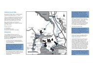
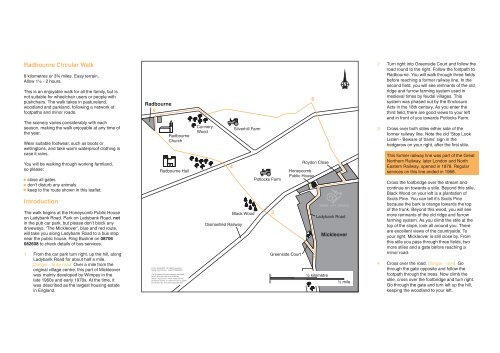
<strong>Radbourne</strong> <strong>Circular</strong> <strong>Walk</strong><br />
6 kilometres or 3¾ miles. Easy terrain.<br />
Allow 1½ - 2 hours.<br />
This is an enjoyable walk for all the family, but is<br />
not suitable for wheelchair users or people with<br />
pushchairs. The walk takes in pasturel<strong>and</strong>,<br />
woodl<strong>and</strong> <strong>and</strong> parkl<strong>and</strong>, following a network of<br />
footpaths <strong>and</strong> minor roads.<br />
The scenery varies considerably with each<br />
season, making the walk enjoyable at any time of<br />
the year.<br />
Wear suitable footwear, such as boots or<br />
wellingtons, <strong>and</strong> take warm waterproof clothing in<br />
case it rains.<br />
You will be walking through working farml<strong>and</strong>,<br />
so please:<br />
Introduction<br />
1<br />
close all gates<br />
don't disturb any animals<br />
keep to the route shown in this leaflet.<br />
The walk begins at the Honeycomb Public House<br />
on Ladybank Road. Park on Ladybank Road, not<br />
in the pub car park, but please don't block any<br />
driveways. ‘The Mickleover’, blue <strong>and</strong> red route,<br />
will take you along Ladybank Road to a bus stop<br />
near the public house. Ring Busline on 08706<br />
082608 to check details of bus services.<br />
From the car park turn right, up the hill, along<br />
Ladybank Road for about half a mile.<br />
Danger - busy road. Over a mile from the<br />
original village centre, this part of Mickleover<br />
was mainly developed by Wimpey in the<br />
late 1960s <strong>and</strong> early 1970s. At the time, it<br />
was described as the largest housing estate<br />
in Engl<strong>and</strong>.<br />
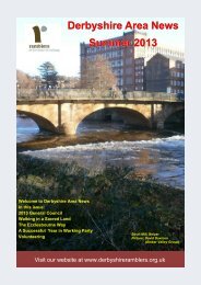
<strong>Radbourne</strong><br />
5<br />
<strong>Radbourne</strong><br />
Church<br />
<strong>Radbourne</strong> Hall<br />
Crown Copyright. All rights reserved.<br />
<strong>Derby</strong> City Council. LA077755(2003)<br />
The Ordnance Survey mapping included<br />
within this web-site is provided by<br />
<strong>Derby</strong> City Council, under licence from<br />
Ordnance Survey, in order to fulfil its public<br />
function to act as a planning authority.<br />
Cunnery<br />
Wood<br />
4<br />
Dismantled Railway<br />
Silverhill Farm<br />
Black Wood<br />
Potlocks Farm<br />
3<br />
Greenside Court<br />
Honeycomb<br />
Public House<br />
Roydon Close<br />
0 ½ kilometre<br />
0<br />
1<br />
6<br />
2<br />
N<br />
DERBY CITY COUNCIL<br />
Ladybank Road<br />
Mickleover<br />
½ mile<br />
2<br />
3<br />
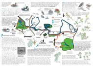
Turn right into Greenside Court <strong>and</strong> follow the<br />
road round to the right. Follow the footpath to<br />
<strong>Radbourne</strong>. You will walk through three fields<br />
before reaching a former railway line. In the<br />
second field, you will see remnants of the old<br />
ridge <strong>and</strong> furrow farming system used in<br />
medieval times by feudal villages. This<br />
system was phased out by the Enclosure<br />
Acts in the 18th century. As you enter the<br />
third field, there are good views to your left<br />
<strong>and</strong> in front of you towards Potlocks Farm.<br />
Cross over both stiles either side of the<br />
former railway line. Note the old ‘Stop Look<br />
Listen - Beware of trains’ sign in the<br />
hedgerow on your right, after the first stile.<br />
This former railway line was part of the Great<br />
Northern Railway, later London <strong>and</strong> North<br />
Eastern Railway, opened in 1878. Regular<br />
services on this line ended in 1968.<br />
Cross the footbridge over the stream <strong>and</strong><br />
continue on towards a stile. Beyond this stile,<br />
Black Wood on your left is a plantation of<br />
Scots Pine. You can tell it’s Scots Pine<br />
because the bark is orange towards the top<br />
of the trunk. Beyond this wood, you will see<br />
more remnants of the old ridge <strong>and</strong> furrow<br />
farming system. As you climb the stile at the<br />
top of the slope, look all around you. There<br />
are excellent views of the countryside. To<br />
your right, Mickleover is still close by. From<br />
this stile you pass through three fields, two<br />
more stiles <strong>and</strong> a gate before reaching a<br />
minor road.<br />
4 Cross over the road. Danger - road. Go<br />
through the gate opposite <strong>and</strong> follow the<br />
footpath through the trees. Now climb the<br />
stile, cross over the footbridge <strong>and</strong> turn right.<br />
Go through the gate <strong>and</strong> turn left up the hill,<br />
keeping the woodl<strong>and</strong> to your left.
As you reach the top of the hill, marked by a<br />
triangular enclosure of young beech trees on<br />
your right, you may see <strong>Radbourne</strong> Hall<br />
ahead of you through the trees.<br />
Radburne Hall - Major Ch<strong>and</strong>os-Pole prefers<br />
this spelling - was built by William Smith of<br />
Warwick for German Pole, pronounced<br />
Jarman Pole, between 1739 - 54 to replace<br />
the earlier house. The first <strong>Radbourne</strong> Hall<br />
was built for Sir John Ch<strong>and</strong>os, one of the<br />
original Knights of the Garter, who died in<br />
1369. The estate has never passed out of the<br />
ownership of the family.<br />
Continue on, heading down the hill. Ahead of<br />
you is <strong>Radbourne</strong> Church.<br />
<strong>Radbourne</strong> Church st<strong>and</strong>s back from the<br />
village in the Hall grounds. Dedicated to St<br />
Andrew, it dates mainly from around 1300,<br />
<strong>and</strong> has a 15th century tower. Inside are fine<br />
monuments to the Pole family <strong>and</strong> 14th <strong>and</strong><br />
15th century woodwork from Dale Abbey<br />
which was brought here by Francis Pole who<br />
bought the Abbey’s contents on its<br />
dissolution.<br />
At the bottom of the hill go through the field<br />
gate <strong>and</strong> carry straight on until you reach the<br />
metal ‘kissing gate’. Pass through this gate,<br />
under the Yew tree, <strong>and</strong> follow the path round<br />
to the left, past the church. You are now in<br />
<strong>Radbourne</strong>. The name probably means ‘the<br />
stream where reeds grow’. Continue along<br />
the path, through the metal gate <strong>and</strong> along<br />
the track until you reach the road. Danger -<br />
road.<br />
6<br />
Go through the gate <strong>and</strong> walk up the field,<br />
heading towards the oak trees in the<br />
distance, to the left of Silverhill Farm. As you<br />
walk up the hill, the views around you open<br />
up. Head towards the solitary oak tree.<br />
The path continues on into the next field. At<br />
the field boundary, follow the line of telegraph<br />
poles. As you walk across this field, look all<br />
around at the excellent views over the open<br />
countryside. The white structure in the<br />
distance on your left is Mackworth Water<br />
Tower.<br />
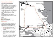
Continue straight on into the next field,<br />
following the line of telegraph poles until you<br />
reach the hedgerow. Keeping the hedgerow<br />
on your right, follow it until you come to a<br />
stile. Climb over the stile <strong>and</strong> continue over<br />
the next field towards Mackworth Water<br />
Tower.<br />
When you reach the hedgerow opposite, turn<br />
sharp right towards the road. Climb the stile,<br />
then cross the road. Danger - road. Pass<br />
through the gate to your left. <strong>Walk</strong> through<br />
the next three fields, keeping the hedgerow to<br />
your right. In the distance is Mickleover.<br />
Cross the former railway line. <strong>Derby</strong> City<br />
Council <strong>and</strong> <strong>Derby</strong>shire County Council have<br />
developed it as a footpath <strong>and</strong> cycleway<br />
linking <strong>Derby</strong> with Etwall. Follow the tarmac<br />
path straight in front of you <strong>and</strong> along Roydon<br />
Close to Ladybank Road. Danger - busy<br />
road.<br />
Enjoy the countryside <strong>and</strong> respect its life <strong>and</strong> work.<br />
Guard against all risk of fire.<br />
Fasten all gates.<br />
Keep your dogs under close control.<br />
Keep to public paths across farml<strong>and</strong>.<br />
Use gates <strong>and</strong> stiles to cross fences, hedges <strong>and</strong><br />
walls.<br />
Leave livestock, crops <strong>and</strong> machinery alone.<br />
Take your litter home.<br />
Help to keep all water clean.<br />
Protect wildlife, plants <strong>and</strong> trees.<br />
Take special care on country roads.<br />
Make no unnecessary noise.<br />
Further Information<br />
Environment Projects Officer<br />
<strong>Derby</strong> City Council<br />
Development <strong>and</strong> Cultural Services<br />
Roman House<br />
Friar Gate<br />
DERBY DE1 1XB<br />
Telephone<br />
Textphone<br />
01332 255021<br />
01332 258427<br />
Many thanks to Roy Christian for the historical information.<br />
This leaflet is one in a series published by <strong>Derby</strong> City Council.<br />
Plain English by<br />
DERBY CITY COUNCIL<br />
Please tell us if you need this document in large print,<br />
on audio tape, computer disc or in Braille. You can<br />
contact us on 01332 255093 or on textphone 01332<br />
258427 or fax 01332 255989. Or use the equipment<br />
at Central Library, Wardwick to convert this into voice<br />
<strong>and</strong> large print. Please contact us if you need help<br />
reading this document or any part of it translating.<br />
<strong>Radbourne</strong><br />
<strong>Circular</strong><br />
<strong>Walk</strong><br />
DERBY CITY COUNCIL<br />
5<br />
Turn right, keeping to the right h<strong>and</strong> verge. To<br />
your right is Cunnery Wood, a cunnery being<br />
a rabbit warren. Keep on the road until you<br />
have gone over the little brick bridge. On the<br />
left, just beyond the bridge, is the sign to the<br />
footpath you will be following.<br />
Turn right <strong>and</strong> head back to the public<br />
house. If you want, you can now have a well<br />
deserved drink or something to eat. If you do<br />
go in the pub, please take your muddy<br />
footwear off. Please remember, don't drink<br />
<strong>and</strong> drive.<br />
Hindi<br />
Punjabi<br />
Urdu<br />
01332 256088<br />
01332 256088<br />
01332 256088<br />
RECYCLED