Derbyshire Area News - Derby and South Derbyshire Ramblers
Derbyshire Area News - Derby and South Derbyshire Ramblers
Derbyshire Area News - Derby and South Derbyshire Ramblers
- No tags were found...

Create successful ePaper yourself
Turn your PDF publications into a flip-book with our unique Google optimized e-Paper software.
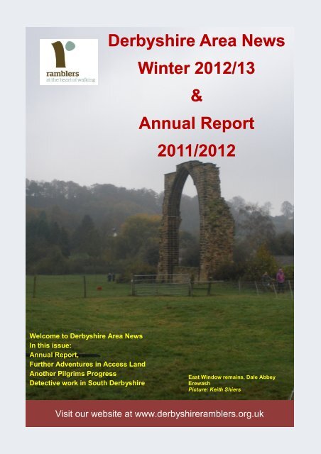
<strong><strong>Derby</strong>shire</strong> <strong>Area</strong> <strong>News</strong>Winter 2012/13&Annual Report2011/2012Welcome to <strong><strong>Derby</strong>shire</strong> <strong>Area</strong> <strong>News</strong>In this issue:Annual Report,Further Adventures in Access L<strong>and</strong>Another Pilgrims ProgressDetective work in <strong>South</strong> <strong><strong>Derby</strong>shire</strong>East Window remains, Dale AbbeyErewashPicture: Keith ShiersVisit our website at www.derbyshireramblers.org.uk
<strong><strong>Derby</strong>shire</strong> <strong>Area</strong> <strong>News</strong>—Winter 2012/132
<strong><strong>Derby</strong>shire</strong> <strong>Area</strong> <strong>News</strong>—Winter 2011/12 2012/13AREA AGMSATURDAY JANUARY 19 th 2013at 2:00 pmWEST HALLAM VILLAGE HALL,THE VILLAGE, WEST HALLAM, ILKESTON,DERBYSHIRE, DE7 6GRSPEAKER: BENEDICT SOUTHWORTHThere will be a short walk in the morning starting from theVillage Hall at 10:00 amRoom will be open at 12 noon <strong>and</strong> tea <strong>and</strong> coffee will beavailable at lunchtime.Benedict <strong>South</strong>worth took over as the <strong>Ramblers</strong> Chief Executive earlier inthe year. In joining the <strong>Ramblers</strong> he brings a wealth of experience in thecharity sector having held senior positions <strong>and</strong> consultancy to a number ofhigh profile <strong>and</strong> environment charities. He recently produced his 100 DayReview, an interesting <strong>and</strong> thought provoking analysis of the <strong>Ramblers</strong> organisationtoday. If you want to be part of the vision for the future then pleaseCome along <strong>and</strong> hear himGetting thereWest Hallam Village Hall is a Grade II listed building located in the heart ofthe village. It can be approached from the north from High Lane West (theA609 Ilkeston road) via either Station Road or St. Wilfred’s Road or from thesouth from Ladywood Road (the A6096) Ilkeston to Spondon road via Cat<strong>and</strong> Fiddle Lane <strong>and</strong> Station Road.There is a large car park at the shopping centre opposite the hall.The Black Cat bus service from <strong>Derby</strong> <strong>and</strong> Ilkeston stops close by.3
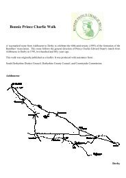
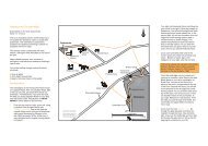
<strong><strong>Derby</strong>shire</strong> <strong>Area</strong> <strong>News</strong>—Winter 2012/13Contents:pageANNUAL REPORT 5–12Treasurer’s Report & Accounts 13-14<strong>Area</strong> Secretary 15-16<strong>Area</strong> Access Officer 16-17<strong>News</strong> Roundup 18Arthur Osborne & Keith Walkerdine’sMemorial Walk 19-20Family Rambles 21Further Adventures in Access L<strong>and</strong> 22-24Another Pilgrim’s Progress 24-25Detective Work in <strong>South</strong> <strong><strong>Derby</strong>shire</strong> 25-27Viewpoint 27Dealing with Dangerous Dogs 28-29A Map Reading Lesson 29Thanks <strong>and</strong> reminders 30Contacts 31Note from the EditorIt is AGM season again <strong>and</strong> so don’t forget —Saturday 19th January 2013—the <strong>Area</strong> AGM.Benedict <strong>South</strong>worth has been kind enough toagree to attend <strong>and</strong> we must thank him for histime in visiting us.The annual reports make for interesting reading<strong>and</strong> it amazes me about the amount ofunsung work undertaken by our officers. Manyare becoming overburdened, so if you feel thatyou can help out in some way then please usethe contacts listed or better still, join your committee.This issue I have been able to include at leastone article from most of our Groups which isvery pleasing. But, do not relax as I shall expectmore for the next issue; in the meantimeenjoy this one <strong>and</strong> good walking.Keith ShiersViews expressed are those of the individual <strong>and</strong> notnecessarily that of <strong>Ramblers</strong>.Copyright for this publication, unless otherwise stated,is held by the <strong>Ramblers</strong>’, <strong><strong>Derby</strong>shire</strong> <strong>Area</strong>.Cover Picture WalkThe remains of the great East Window of St. Mary’s Abbey is a forlorn reminder of a great abbeythat once stood here <strong>and</strong> owned 24,000 acres of l<strong>and</strong> until its dissolution in 1538.This walk is one from an excellent series of 20 leaflet walks published by Erewash BoroughCouncil <strong>and</strong> all available from local libraries or download from their web site. A number of thewalks in the series pass by this feature but the one chosen - Number 1, The Hermits Walk -though short at 3.5 miles, takes in some of the rich heritage of the area which is criss-crossed bymany public footpaths. The terrain is undulating countryside with a variety of surfaces that canbe muddy in places; there is one stretch of quiet country road <strong>and</strong> short length of urban walking.The walk starts at Pioneer Meadows, Kirk Hallam, a public open space comprising wildflowermeadows, woodl<strong>and</strong> <strong>and</strong> a fish pond. There is a car park, alternatively there is a bus route nearbyif one can use public transport. The route passes through the meadows <strong>and</strong> after crossingSow Brook, heads across open fields towards a tip crossing the track bed of a former mineralrailway. This once linked the Stanton Ironworks with the two collieries at Dale, local clay pits <strong>and</strong>a s<strong>and</strong> quarry at Arbour Hill, The route continues across fields to a track that leads to FurnacePond. The pond probably takes its name from 18th century blast furnaces on the site <strong>and</strong> wouldhave been dug to power water driven bellows, it is now the preserve of fishermen. The tracksoon joins Dale Road which is followed towards its namesake before crossing Potato Pit Lane tojoin a bridleway. This passes through Hermits Wood, an ancient woodl<strong>and</strong> <strong>and</strong> site of Hermit’sCave, home of a <strong>Derby</strong> baker (c1130) who was led to the area by a vision of the Virgin Mary.The bridleway continues through the yard of Church Farm, passing All Saints church, a rareexample of church <strong>and</strong> house (<strong>and</strong> pub at one time). <strong>and</strong> into Dale Abbey. Walk through thevillage, past The Carpenter’s Arms (one of a number of walker friendly pubs in the area) beforecrossing fields up hill to attain the outskirts of Kirk Hallam <strong>and</strong> short urban walk to start point.For more information about the series of leaflet walks visit www.erewash.gov.uk4
<strong><strong>Derby</strong>shire</strong> <strong>Area</strong> <strong>News</strong>—Winter 2012/13DERBYSHIRE AREAANNUAL REPORTFor the year ending 30th September 2012AGM to be held at West Hallam Village Hall, Ilkeston,Saturday January 19th 2013 at 2:00 pmSECRETARY’S REPORTMartin PapeDuring year October 2011 to September 2012 we held three <strong>Area</strong> Council meetings.Our <strong>Area</strong> AGM was in January 2012 in Matlock, organised by <strong><strong>Derby</strong>shire</strong> DalesGroup, chaired by Nick Stephens, <strong>and</strong> preceded by a pleasant walk led by JanetKeyne taking in High Tor <strong>and</strong> Willersley Castle grounds. Tributes were paid to KeithWalkerdine <strong>and</strong> Judy Grundy. Our President, John Beadle, expressed his concernsabout cuts to funding for National Parks, changes to the management of the PeakPark, <strong>and</strong> proposed changes to planning regulations. Colin Barker stood down asCountryside Secretary. Gerry White offered to continue his chairing of <strong>Area</strong> Councilmeetings. There were no proposals of motions for the 2012 <strong>Ramblers</strong> GeneralCouncil. <strong>Ramblers</strong>' President-elect Kate Ashbrook was our guest speaker <strong>and</strong> hertalk covered a wide range of issues including the 80th anniversary of the Kindermass trespass, slow progress on coastal access, the saving the forests campaign,membership issues <strong>and</strong> the <strong>Ramblers</strong>' bid for taking on co-ordination of Walking forHealth. She suggested that the appointment of a new <strong>Ramblers</strong> Chief Executive,Benedict <strong>South</strong>worth, may in time lead to changes to the structure of the Association.Apart from the AGM, our other significant <strong>Area</strong> events were:- the <strong>Area</strong>-Get-Together in October 2011 which was at Calton Lees / Baslow, organisedby Amber Valley Group, <strong>and</strong> with a good turn-out of around 60 members;- publication of a leaflet describing The Arthur Osborne <strong>and</strong> Keith Walkerdine MemorialWalk which runs from <strong>Derby</strong> Cathedral through Markeaton <strong>and</strong> Allestree Parks toDuffield; <strong>and</strong>- the launch event in August 2012 for the Memorial Walk, organised by <strong>Derby</strong> &<strong>South</strong> <strong><strong>Derby</strong>shire</strong> Group, led by Petra Hedges, <strong>and</strong> with around 50 attendees includingKate Ashbrook, John Beadle <strong>and</strong> family members of Arthur <strong>and</strong> Keith.5
<strong><strong>Derby</strong>shire</strong> <strong>Area</strong> <strong>News</strong>—Winter 2012/13Two members attended Rambler's 2012 General Council in Leicester.The greatest achievement of the <strong>Ramblers</strong> in <strong><strong>Derby</strong>shire</strong> remains our Groups' excellentwalks programmes; thanks are again due to those many volunteers who organise<strong>and</strong> lead the walks. We are also grateful for the efforts of our Footpath Secretaries,Membership Secretaries <strong>and</strong> Treasurers. However, we still have vacancies on our<strong>Area</strong> Council <strong>and</strong> Group Committees. The more that tasks can be shared betweenCouncil <strong>and</strong> Group officers, the more we can achieve <strong>and</strong> the less risk there is of incumbentsfinding their roles too dem<strong>and</strong>ing. At <strong>Area</strong> Council we have been lacking aChair, Countryside Secretary <strong>and</strong> Publicity Secretary. The absence of an <strong>Area</strong> PublicityOfficer means that we do not have a point of contact for the local media <strong>and</strong> thatwe are not generating as much publicity as we should to encourage people to join the<strong>Ramblers</strong> <strong>and</strong> take up recreational walking. If you may be able to consider taking onany of these roles (or my role as Secretary which could enable me to move on to anotherrole), please let me know.MEMBERSHIP SECRETARY’S REPORTChris VaughanMembership currently st<strong>and</strong>s at 1420 compared to 1463 this time last year. Newmember reports are now being sent directly to Group membership Secretaries. Thefull monthly reports still only come to the <strong>Area</strong> Membership Secretary.WEBMASTERCurrently snowed under by requests from other Groups for web site hosting;ramblers-webs.org.uk currently hosts 49 domains.Would still welcome someone to take over editing the derbyshireramblers.org.uk site.FOOTPATHS SECRETARY’S REPORTOff-RoadingGeof ColeThe use of motorized recreational motor vehicles (rmvs) on unsurfaced public rights ofway (PRoW) continues to cause concern amongst residents <strong>and</strong> other users alike.On behalf of the <strong>Ramblers</strong>, I have commented on the new off-roading managementplans for both the Peak District National Park Authority (PDNPA) <strong>and</strong> <strong><strong>Derby</strong>shire</strong>County Council (DCC), arguing that both organisations should be more active in managingoff-roading. In addition, I have supported Traffic Regulation Orders to stop offroadersfrom using the most sensitive routes in the Peak District. Members can helpby commenting on the PDNPA consultation on traffic restrictions on Long Causeway(Stanage) <strong>and</strong> The Roych (near Chapel) via the PDNPA website.6
The Chesterfield <strong>and</strong> North-East <strong><strong>Derby</strong>shire</strong> <strong>Ramblers</strong>’ Group has approached CentralOffice to ask for a national campaign on off-roading. Central Office seem to thinkthere is little appetite for such a national campaign but have offered to help a localone. We expect a meeting to look at what could be done later this year, which is likelyto include members from all local <strong>Ramblers</strong>’ Groups.DCC Rights of Way Improvement PlanDCC are revising the Rights of Way Improvement Plan, which was first issued 5 yearsago. I am on the working group looking at how it can be improved. It is not an excitingread, but is an important document as it defines the Council’s priorities on rights ofway for the next 5 years. Anything missing is unlikely to be given funding <strong>and</strong> our aimis to correct errors <strong>and</strong> omission from the first edition.Public Rights of Way SurveyGroups continue to help DCC with their 6 monthly survey of public rights of way. TheCouncil survey 5% of its PRoWs each year. In the May survey this year, the pass rateof 71% across <strong><strong>Derby</strong>shire</strong> compared with the Council target of 72.5%.Open Access L<strong>and</strong> SurveyI’ve agreed to join a team from the D&DLAF who will look at the open access l<strong>and</strong> in<strong><strong>Derby</strong>shire</strong>, outside of the Peak District. The intention is to see what could be done toimprove access, marking <strong>and</strong> public awareness. I’ll keep Sue Weatherley (our accessofficer) advised of progress - if any.DCCA recent <strong>Ramblers</strong> Central Office investigation has shown that we are fortunate in<strong><strong>Derby</strong>shire</strong> in that the local government funding cuts have had little impact on rights ofway so far. However, we need to keep lobbying on the benefits of walking <strong>and</strong> accessto green spaces to both individual <strong>and</strong> community health to maintain this position.DCC has appointed a Volunteer Co-ordinator – Steve Cresswell – to help volunteersto tackle work on public rights of way. He has already met with some of our GroupFootpath Secretaries <strong>and</strong> will be speaking at our next <strong><strong>Derby</strong>shire</strong> Public Rights of WayCommittee.And Finally<strong><strong>Derby</strong>shire</strong> <strong>Area</strong> <strong>News</strong>—Winter 2012/13Keith Shiers has obtained some interesting path maintenance statistics from DCC. Acomparison of the outst<strong>and</strong>ing reported problems with the length of the path networkin each District shows that the <strong><strong>Derby</strong>shire</strong> Dales has the lowest number of reportedproblems per kilometre whilst <strong>South</strong> <strong><strong>Derby</strong>shire</strong> has the highest. In the Dales you canexpect to come across a known problem every 15 km compared with 1.5 km in <strong>South</strong><strong><strong>Derby</strong>shire</strong>. For completion Amber Valley comes out at 10.5km <strong>and</strong> Erewash at7
<strong><strong>Derby</strong>shire</strong> <strong>Area</strong> <strong>News</strong>—Winter 2012/132.8km. I suspect that some of the variation is due to the different types of terrain <strong>and</strong>farming across the districts; but the Dales also benefits from the work of the PeakPark Rangers on a lot of its paths.ACCESS OFFICER’S REPORTSue WeatherleyI have attended all the meetings of the Peak District Local Access Forum this year<strong>and</strong> also meetings of the two sub-groups dealing with Access <strong>and</strong> Green Lanes. Offroadingin the National Park has been a permanent agenda item <strong>and</strong> has been thesubject of much discussion. Management plans for the third batch of high priorityroutes are being preparedLast year the Peak District National Park reviewed its policy on off-roading. This resultedin funding for extra staffing to tackle the issue over the next two years. Consultationsabout the introduction of Traffic Regulation Orders on 4 routes have been instigated.The routes involved are Long Causeway, The Roych, Chertpit Lane <strong>and</strong> theBrushfield/Upperdale Track.The Access Sub Group of the LAF has met to discuss various matters including possiblenew access points, the review of any restrictions to CROW Access L<strong>and</strong> <strong>and</strong>also we have commented on the changes to the management of the Peak DistrictEstates. In the spring a meeting of this group agreed a ‘wish list’ of ideas for enhancedaccess to Access L<strong>and</strong>. It is progress that these ideas are recorded but thereality of the present financial situation means that we can expect little progress in thenear future; however having these recorded allows any opportunity that arises to beutilised.During the year it has been agreed that The Staffordshire Wildlife Trust will take overfuture management of the Roaches Estate.I continue to act as a LAF observer on the committee of the Peak District GreenLanes Alliance. Full details of this organisation can be found on: www.pdgla.org.ukGROUP REPORTS**********************************************AMBER VALLEYGroup Committee:President <strong>and</strong> Footpath SecretaryVice PresidentChairmanVice Chairman <strong>and</strong> Membership SecretarySecretaryTreasurerAssistant Footpath Secretary8John MorrisseyDick HallGerry WhiteKeith HowkinsChristine LevasseurMike HuftonMichael Poyser
<strong><strong>Derby</strong>shire</strong> <strong>Area</strong> <strong>News</strong>—Winter 2012/13WebmasterAway Weekends OrganiserWalks Co-ordinatorProgramme PublisherSocial SecretaryCommittee MemberDavid DavidsonSue GlitheroJohn ToplissMartin PhillipsPeter SwannKen LaneDuring the year slight changes occurred to these responsibilities <strong>and</strong> thesewill be formalised in the forthcoming year.The committee met on 3 occasions in 2011/12 <strong>and</strong> were represented at <strong>Area</strong> Meetingson the Group’s behalf. Mike Hufton is now the <strong>Area</strong> Treasurer but retains hisposition with Amber Valley <strong>and</strong> Gerry White has agreed to chair <strong>Area</strong> meetings until asubstantive appointment is made to that post.We were again involved with the Amber Valley <strong>and</strong> Erewash Autumn Footprints programme(organised by Groundwork <strong>Derby</strong> <strong>and</strong> <strong><strong>Derby</strong>shire</strong>) with Gerry White <strong>and</strong>David Davison meetings to help mount the festival. This year was its 10th running<strong>and</strong> we increased our involvement by leading 4 well attended walks. If anyone wantsto lead walks next year, assuming the programme goes ahead again, please let usknow. Attendance at meetings is not required.Our own walks programmes have been issued as customary, twice in the year. Aperceptible change in attendance has occurred. Whilst we have averaged about 15people per walk on Sundays, the shorter Wednesday walks (4 hours duration) regularlyexceeds this, whilst the Friday outings—of about 4 miles—have been a real success.Interestingly these midweek walks are advertised only via the website <strong>and</strong> wordof mouth because of their informality, not on the printed programme. We thank allthose who have led walks throughout the year <strong>and</strong> would love to see others comingforward as leaders of walks of any length.Martin Phillips has stepped in to h<strong>and</strong>le the production of the programme <strong>and</strong> liaisonwith the printer for which we are very grateful as the walking programme is our staplediet throughout the year.The popularity of the Amber Valley website increases <strong>and</strong> seems more interestingnow that it is being used by members for articles <strong>and</strong> the passing of information <strong>and</strong>announcements. It is there for utilisation by any member, please contact David Davidsonif you wish to make use of it.We enjoyed 5 Friday winter evening presentations at the Strutts Community Centre<strong>and</strong> encourage anyone who wants to share their walking or holiday experiences withus to come forward. Peter Swann has now taken over arranging these <strong>and</strong> can becontacted for more information.Our Annual Dinner was held this year at Alison House, Cromford (arranged by DickHall), but the traditional Midsummer Buffet had to be cancelled because of lack ofinterest. We are currently reviewing whether to go ahead with a similar event in 2013.Away weekends continue as a key feature in our activities <strong>and</strong> we have had im-9
<strong><strong>Derby</strong>shire</strong> <strong>Area</strong> <strong>News</strong>—Winter 2012/13mensely enjoyable visits to Mallamdale, Lorton Vale, Cumbria <strong>and</strong> Whitby this year,the latter saturated with autumn sunshine. Thanks to Sue Glithero for her energy inorganising these which were enhanced by good food <strong>and</strong> interesting walking routes ofvarious lengths.Extra curricular trekking activities have included the Offas Dyke, the French Auvergne<strong>and</strong> the Swiss Alps. More details of these are on the Amber Valley website under“recent articles”.Gerry White, ChairmanDERBY & SOUTH DERBYSHIREWALKING: Attendance for all our programme walks continues to hold up. In particularour new short walks on alternate Sunday mornings in <strong>and</strong> around <strong>South</strong> <strong><strong>Derby</strong>shire</strong>have been a tremendous success, with numbers ranging from around 9 to 31. Thewalks are attracting a mix of new walkers plus some old faces who have ‘down-sized’<strong>and</strong> what’s particularly nice – there’s often a mix of ages. Also, they have a later startof 11.00 am to fit in with using public transport. So many thanks to the organisers,leaders <strong>and</strong> four legged friends (you know who you are!).We were pleased to see RA President Kate Ashbrook <strong>and</strong> so many members <strong>and</strong>friends turn out for the memorial walk for Keith Walkerdine <strong>and</strong> Arthur Osborne in August.FOOTPATHS UPDATEOur Practical Footpath workers continue to clip, strim <strong>and</strong> report problems.BVPI,'Ease of Use' Survey for DCC May 2012 -9 of FP Wardens surveyed 28 paths in S.<strong>Derby</strong>s. 20 passed. Because the paths areselected r<strong>and</strong>omly the results between one survey <strong>and</strong> another are rather erratic.Hartshorne FP24 – Proposed Diversion of Path currently goes through what usedto be a farmyard but is now an abattoir. I have accepted the diversion, as proposed.Foston & Scropton Diversion proposal -This appears to be a retrospective diversion.Isuggested a variation on the proposal to avoid a very muddy area where a stilecoincides with the entry/exit for cattle from the farmyard.Dalbury Lees FP26 – It looks as if this long running controversial Proposed Diversionis being finally sorted out. The latest Proposal is for the path to go along the northernside of the Village Hall car park. The rest of this path to remain as it is.Proposed Stopping up of Marston Lane (part), Hatton – Nestle have submitted aPlanning Application (9/2012/0630) to exp<strong>and</strong> their factory at Hatton.David Varley, Footpath SecretaryFinally, a slightly negative observation is that membership is falling slightly so we aremaking more effort to raise our profile <strong>and</strong> encourage people to join.Kate Lee, Chair10
<strong><strong>Derby</strong>shire</strong> <strong>Area</strong> <strong>News</strong>—Winter 2012/13DERBYSHIRE DALESThe main items of concern are the fact that Geof Cole is resigning as our FootpathsSecretary <strong>and</strong> John Riddall (at age 86) feels he ought to give up as our CountrysideSecretary. Whilst John has done a superb job <strong>and</strong> has hassled the local council formany years, Geof’s job (extremely well done by Geof) definitely needs someone tocarry on the good work. At present we do not have any replacements so maybe aplea in the <strong>Area</strong> <strong>News</strong> might raise some interest. Our AGM is on Friday 16th Novemberat the Imperial Rooms, Matlock. Membership is steady at 600+ <strong>and</strong> we are averaging8-9 walks per week. The summer walks/meals were reinstated—one on a verysunny evening, the other a very wet night! Friday night social evenings continuethanks to the hard work of my good wife, Pat.NOTE, the good news is that Geof is prepared to continue as <strong>Area</strong> Footpath Secretary,but we are still desperate for replacements for both Group positions.Nick Stephens, ChairmanEREWASHOur annual report was presented at our AGM on 17 th October 2012. There have beenchanges to the committee with the retirement of long serving members Beryl Wharton<strong>and</strong> Joyce Mold, our Social Secretary of 20 years plus <strong>and</strong> our thanks to them bothfor their distinguished service to the Group. Joyce will remain on the committee whilstMargaret Chapman has taken on Social Secretary <strong>and</strong> Reg Murray has joined thecommittee. Brian Bennett joined the committee earlier in the year <strong>and</strong> taken on thetask of Countryside Secretary for the Group. He has diligently vetted all matters relatingto planning applications which has helped reduce the workload of the FootpathSecretary. Hilda Wright continues to control our finances admirably.Walks Programme: Our normal programme has been maintained offering walks onalternate Sundays, Mondays <strong>and</strong> Thursdays. Attendance has been rather variable. Inthe first half of the year we were seeing up to fifty people on Monday <strong>and</strong> Thursdaywalks but have decreased to an average of 25 whilst Sunday walks have an averageof about 15. The Short Walks programme has had mixed fortunes with some slackeningof interest. At the AGM, the Group agreed to continue a short walks programmeover the winter at reduced frequency. There were a number of evening walks thatproved popular but a trial afternoon walk was not. We included walks in the “Festivalof Winter Walks”, led walks at the “<strong>Area</strong> Get Together” <strong>and</strong> provided three led walksfor the Amber Valley <strong>and</strong> Erewash Autumn Footprints walking festival.Membership: Although membership is down by 9 on this time last year at 231 wehave, in fact, recruited 33 new members during this period. Thanks to Dorothy Dentfor her enthusiasm in chasing up membership.11
<strong><strong>Derby</strong>shire</strong> <strong>Area</strong> <strong>News</strong>—Winter 2012/13Publicity: We have had good press coverage this year thanks to S<strong>and</strong>ie Joneswhich has included reports on the work of the volunteers <strong>and</strong> the success of theshort walk programme. We also attended a number of festivals with our display st<strong>and</strong><strong>and</strong> participated in local Xmas Tree <strong>and</strong> Scarecrow festivals. Thanks too to our Webmaster,Tony Beardsley, who keeps the outside world informed of our ventures.Footpaths: We have received 8 statutory notices <strong>and</strong> reported13 footpath problemsthis year <strong>and</strong> have supported the Ilkeston Local Historical Society in pursuit of reopeningan ancient path. Assisting with DCC “Ease of Use” surveys, a total of 49paths were surveyed of which 2 failed. Two Erewash leaflet walks were also surveyedas part of our partnership with the Erewash Footpaths <strong>and</strong> Bridleways Initiative(FBI) local user group forum. Thanks also to member volunteers who have taken“ownership” of the Erewash section of The Centenary Way survey <strong>and</strong> to our 6 FootpathWardens who monitor local footpaths.Social: Our Social programme continues to be successful <strong>and</strong> it is pleasing that somany members continue to support <strong>and</strong> enjoy them. We have enjoyed a variety ofthemes this year; thanks to our tireless Social Secretary, Joyce Mold <strong>and</strong> helpers forthe smooth running <strong>and</strong> to Tony Beardsley for doing the bookings.We enjoyed our usual two weekends away this year <strong>and</strong> have recently returned fromour latest, walking the Mendips. The weather was balmy, the walks were excellent<strong>and</strong> views superb. Together with good company, food <strong>and</strong> wine what more could onewish for.Our day trip in June returned to the old favourite spot of Holmfirth though the weathermade for two challenging walks.Volunteers: The Volunteers have been very active this year. They have been involvedin a variety of tasks from undergrowth clearing <strong>and</strong> sapling planting to erectingway mark posts <strong>and</strong> wicket gates. The work has been done in association withthe Ranger Service.Our members have again been honoured by visits from the Erewash Mayor; JaneMarshall during her usual Tea <strong>and</strong> Cake charity fund raising event that coincides withone of the Autumn Footprints Walking Festival walks <strong>and</strong> Tony Beardsley had a similarcall following his involvement <strong>and</strong> effort in route planning the Mayor’s Marathonthat is part of the Mayor’s charity fund raising events.Keith Shiers, Chairman12
AREA SECRETARY<strong>Area</strong> eventsI hope you have enjoyed some good walks during this past summer. The main <strong>Area</strong>events have been the launch event in August for the Arthur Osborne <strong>and</strong> Keith WalkerdineMemorial Walk (see separate article) <strong>and</strong> the <strong>Area</strong> Get Together at the end ofOctober - this article was written before the latter had taken place. We have startedour planning for the <strong>Area</strong> AGM in January (see notice elsewhere) <strong>and</strong> we are verypleased that our guest speaker will be the <strong>Ramblers</strong> Chief Executive - Benedict<strong>South</strong>worth.General CouncilOur delegates to the 2012 <strong>Ramblers</strong>' General Council were Geof Cole <strong>and</strong> MikeHufton. Motions passed at the Council included:- support for <strong>Area</strong> <strong>and</strong> Group involvement in maintaining ROWs;- opposition to the <strong>Ramblers</strong>' partnership with BUPA;- continuing concern about the <strong>Ramblers</strong> choice of partnership with HF Holidays ratherthan <strong>Ramblers</strong> Holidays;- working with the Canal <strong>and</strong> River Trust to maintain <strong>and</strong> improve towpaths <strong>and</strong> accessto towpaths; <strong>and</strong>- making increased efforts to recruit to the <strong>Ramblers</strong> walkers who support the <strong>Ramblers</strong>'aims but who prefer to walk independently.I have been pushing for the last of these for some years as there must be many suchwalkers, <strong>and</strong> those that are members make a valuable contribution to the <strong>Ramblers</strong>both through paying their subscriptions <strong>and</strong>, in some cases, working hard on <strong>Ramblers</strong>'campaigning activities.Other national news<strong><strong>Derby</strong>shire</strong> <strong>Area</strong> <strong>News</strong>—Winter 2012/13- <strong>Ramblers</strong> are concerned about Natural Engl<strong>and</strong>'s National Trails Review, whichproposes management of trails by partnerships. This could lead to varying <strong>and</strong> deterioratingst<strong>and</strong>ards, including loss of National Trail Officer posts. A petition expressingconcerns about the proposals can be found via the <strong>Ramblers</strong>' website.- Benedict <strong>South</strong>worth has written a report giving his views on the organisation of the<strong>Ramblers</strong> which could lead to some beneficial changes.- <strong>Ramblers</strong> has made a detailed response to DEFRA's consultation on ROWs.15
- <strong>Ramblers</strong> has published statistics on cuts to Council's ROW funding, showing that70% of Councils have cut their ROW budgets over the past 3 years, with 11% cuttingby more than 50%.- <strong>Ramblers</strong>' walking festivals dates: Festival of Winter Walks 22/12/12 - 6/1/13, <strong>and</strong>Get Walking Week 4/5/13 - 11/5/13.- <strong>Ramblers</strong> has produced a new booklet "The Heart of Walking" for use in promotingthe Association.I hope these news items give you confidence that the <strong>Ramblers</strong> remains active incampaigning on matters of importance to walkers.Work partiesErewash Group already has a team that are carrying out path maintenance tasks, <strong>and</strong>Amber Valley Group are setting up a similar team. The County Council is keen toencourage <strong>and</strong> support volunteers for maintenance work <strong>and</strong> they have appointed aVolunteers' Co-ordinator, Steve Cresswell. If you may be able take part in pathmaintenance work, even if only for a day or two per year, would you please contactKeith Shiers if you are in Erewash Group, John Morrissey if you are in Amber ValleyGroup, Chris Vaughan if you are in <strong>Derby</strong> & <strong>South</strong> <strong><strong>Derby</strong>shire</strong> Group or myself if youare in <strong><strong>Derby</strong>shire</strong> Dales Group. It would be useful to know whether you would beavailable for weekday work parties as well as at weekends.Officer vacanciesBy the time you read this newsletter, most of our Group AGMs will have taken place.I make my usual plea for members to consider whether they might be able to fill vacancieson <strong>Area</strong> Council or Group Committees. The more that tasks can be sharedbetween Council members <strong>and</strong> between Committee members, the more we canachieve <strong>and</strong> the less risk there is of incumbents finding their roles too dem<strong>and</strong>ing. At<strong>Area</strong> Council we have been lacking a Chair, Countryside Secretary <strong>and</strong> Publicity Secretary.If you may be able to consider taking on any of these roles (or my role as Secretarywhich could enable me to move on to another role), please let me know.Thank you again for your continuing support of the <strong>Ramblers</strong>.Martin Pape<strong>Area</strong> Access OfficerAdventures in Access L<strong>and</strong><strong><strong>Derby</strong>shire</strong> <strong>Area</strong> <strong>News</strong>—Winter 2012/13I have been doing some walking in the Wetton Mill area recently <strong>and</strong> exploring theaccess l<strong>and</strong> round there. Ecton Hill <strong>and</strong> Wetton Hill are the obvious targets <strong>and</strong> the16
<strong><strong>Derby</strong>shire</strong> <strong>Area</strong> <strong>News</strong>—Winter 2012/13summits of both these hills can easily be reached from the footpaths that skirt theslopes.The summit of Ecton Hill is a complex area with an interesting history of mining <strong>and</strong>there are traces of this seen all over the hill summit <strong>and</strong> slopes. There is good accessto the summit from all directions <strong>and</strong> additional access maps at GR 103575 <strong>and</strong>100582. Also there is a concession path up from Ecton which takes a better line thanthe zigzag route up the steep hillside. This path starts at GR 097584 <strong>and</strong> takes a gentleascending line round the hill side to join other paths by some of the old mine workingsat GR 099585.The best route over the access l<strong>and</strong> south of Ecton Hill <strong>and</strong> on the east side of theManifold valley is to start at GR 096576 <strong>and</strong> follow the edge of the access l<strong>and</strong> alongto GR 095565 where the track into the valley between Dale Farm <strong>and</strong> Sugarloaf canbe followed down to join the footpath at GR 097566.From this point you can see Sugarloaf ahead. Follow the valley up towards this <strong>and</strong>then go right to the corner of a fence. There is a stile here, at GR 098567, which isquite well hidden by bushes. Once over the stile you can follow round the base ofSugarloaf <strong>and</strong> then climb up the hillside to the south east. The ridge at the top of theslope gives good views of the Manifold Valley <strong>and</strong> lovely flowers in the summer <strong>and</strong>you can follow it along towards Wetton Mill. You can join the footpath from ManorHouse by descending south eastwards, it is a lovely little ridge but if you go too fardown there are some thick bushes to get round.Wetton Hill has two summits, the highest tops out at 371m <strong>and</strong> can easily be reachedby the paths that surround the hill. The other summit reaches 358m <strong>and</strong> there is anaccess point at GR107563, once reached there are lovely views if you descend to thetop of the steep slopes above the Manifold valley. To drop back down to Wetton Mill itis best to skirt the steepest slopes <strong>and</strong> join the path down from Manor House. If youlook carefully at the map you will see there is a steep valley which drops down to theroad at GR 099556. You can reach the bottom of this from the path which joins theroad a 100m or so to the west at GR 098556. It is a steep climb up through the valley<strong>and</strong> might almost be described as a scramble, you will need to use h<strong>and</strong>s as well asfeet at least once, however for the intrepid explorer it gives an interesting ascent,good views from the top <strong>and</strong> in the summer some lovely limestone flowers.Sue Weatherley <strong>Area</strong> Access Officer17
KEITH WALKERDINE, <strong><strong>Derby</strong>shire</strong> 1937 <strong>Area</strong> -2011 <strong>News</strong>—Winter 2012/13NEWS ROUNDUPTony Beardsley unveiling the MemorialPlaque to Mike JoblingErewash memorial PlaqueErewash <strong>Ramblers</strong> unveiled a MemorialPlaque to Mike Jobling, one of their foundermembers who died earlier in the year. TonyBeardsley, another founder member, performedthe honour. The plaque is fixed to agate with the kind permission of Mr Peacock,l<strong>and</strong>owner, in an area of Erewash wellloved <strong>and</strong> walked by Mike.Tony has had a busy year because not onlyis he the Group’s Secretary, ProgrammeSecretary <strong>and</strong> Webmaster but he also deviseda route for the Erewash Mayor’s MarathonWalk that she has used as part of herCharity fund raising year. The walk tookplace on Saturday 6th October <strong>and</strong> membersof the Group joined in at various stagesof the walk.<strong>Ramblers</strong> Routes DatabaseAmber Valley’s David Davidson was “volunteered” to become a ‘checker’ for the national<strong>Ramblers</strong> Routes database. They have contributed to the first walk given tothem which has now been published.<strong>Area</strong> Get TogetherWell the weather stayed fine, most of the day anyway, for an amazing gathering of 72members to enjoy a selection of 5, 7, 9.5 or 13 mile walks from Calke Abbey. Thearea is a treasure trove of walks <strong>and</strong> no one was disappointed in the choices providedby D&SD Group. The colours in the trees were magnificent <strong>and</strong> I, for one, admit toreverting to childish behaviour in running through the leaves; I shall not mention negotiatingthrough the mud though! There was local history <strong>and</strong> adventure in walkingthrough the tunnels, more so if one had forgotten a torch, <strong>and</strong> some stunning viewseven in this most southerly point of the county. It all came together at lunch when allthe walking groups met together at Ticknall Village Hall to reacquaint with old friends,meet new ones <strong>and</strong> enjoy the tea <strong>and</strong> home baking with a superb backdrop of a slideshow of D&SD pictures.Another lovely day, good company <strong>and</strong> a huge thank you to <strong>Derby</strong> & <strong>South</strong> <strong><strong>Derby</strong>shire</strong>Group for organising it; the helpers for baking, tea making <strong>and</strong> clearing up <strong>and</strong>the walk leaders. See everyone next year—don’t miss it.18
<strong><strong>Derby</strong>shire</strong> <strong>Area</strong> <strong>News</strong>—Winter 2012/13Launch event for The Arthur Osborne <strong>and</strong> Keith Walkerdine Memorial WalkYou should all have received a copy of the leaflet that we have produced that describesa walk in memory of two stalwarts of our <strong>Ramblers</strong> <strong>Area</strong> - Arthur Osborne <strong>and</strong>Keith Walkerdine. The walk runs for 6 miles from <strong>Derby</strong> Cathedral to MarkeatonPark, Allestree Park <strong>and</strong> Duffield. The launch event for the walk was on 5th August<strong>and</strong> was well attended by about 50 members <strong>and</strong> visitors. We were very pleased thatour national President of the <strong>Ramblers</strong>, Kate Ashbrook, our <strong>Area</strong> President, JohnBeadle, our <strong>Area</strong> Vice Presidents Joy Osborne <strong>and</strong> Tony Beardsley, <strong>and</strong> severalmembers of both Arthur's <strong>and</strong> Keith's families were able to be with us.The event started with a couple of brief speeches by Kate <strong>and</strong> John who both paidtribute to the huge contributions made by Arthur <strong>and</strong> Keith to the development of the<strong>Ramblers</strong> Association in <strong><strong>Derby</strong>shire</strong>. Most of us then walked the route, ably guidedby Petra Hedges, enjoying good company <strong>and</strong> the variety of scenery that the walkfeatures, from city centre to suburbs <strong>and</strong> parkl<strong>and</strong> <strong>and</strong>, eventually, attractive countryside.19
<strong><strong>Derby</strong>shire</strong> <strong>Area</strong> <strong>News</strong>—Winter 2012/13Thanks to Kate Lee's efforts, <strong>and</strong> withcontributions from S<strong>and</strong>ie Jones, SheilaDavis <strong>and</strong> myself, there was an almostfull page article in the <strong>Derby</strong> Telegraphon the Friday before the launch eventwhich gave good publicity to the <strong>Ramblers</strong>locally <strong>and</strong> to the Memorial Walk.The theme that the Telegraph's reporterwas determined to develop was that the<strong>Ramblers</strong> are not only about hikes onwindswept hillsides but we are alsohoping to encourage new walkers byorganising walks in urban areas <strong>and</strong> on the urban fringe.There was one very muddy patch on the walk, on the approach to a small bridge overa ditch near Burleywood Farm between Bunker Hill <strong>and</strong> Duffield. I have spoken to theCounty Council's Rights of Way Officer about this <strong>and</strong> he assured me that work toimprove the drainage in this area should be completed later this year.Thanks again to Petra for leading the walk, to Kate Lee for arranging the publicity, toKate Ashbrook for travelling up to <strong><strong>Derby</strong>shire</strong> <strong>and</strong> showing that <strong>Ramblers</strong> at nationallevel want to keep in touch with what is happening at area <strong>and</strong> group levels, <strong>and</strong> to allthose who came to the launch event.Martin PapeADVERTISING RATESThe ‘<strong><strong>Derby</strong>shire</strong> <strong>Area</strong> <strong>News</strong>’ is published twice yearly <strong>and</strong> circulated at the end of May <strong>and</strong>November to its 1500 members <strong>and</strong> other associated organisations within the area. If you wouldlike to advertise our rates are very competitive:Colour Advertisements - back page, inside outer cover only.Full page (18.5cm high x 12.3cm wide) £60Half page (12.3cm wide x 8.5cm high) £35Black <strong>and</strong> White AdvertisementsFull page (18.5cm high x 12.3cm wide) £45Half page (12.3cm wide x 8.5cm high) £25Quarter page ((6.15cm high x 12.3cm wide) £15Please contact Keith Shiers on 01332 665902 for further information or email your own materialto kashiers@tiscali.co.uk.20
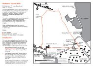
<strong><strong>Derby</strong>shire</strong> <strong>Area</strong> <strong>News</strong>—Winter 2012/13Family RamblesDot Morson (D&SD Group)A Family opportunity—Permissive paths on Calke Abbey Estate.Two new permissive paths have been completed on the estate over recent weeks. Ihave offered two short walks which gives the opportunity to use them. The first is suitablefor all-terrain buggies or pushchairs <strong>and</strong> maybe wheelchairs or mobility scootersif they are sturdy with good wheels. A torch would be useful when walking through thetunnels. The second has 3 gap stiles that could be awkward for pushchairs.Route 1; Easy access to the Limeyards.Allow an hour.Park in Ticknall village <strong>and</strong> take High Street (B5006) south towards Ashby. The surfacedpath is reached beyond the village past some metal railings. Turn left to reachthe Ticknall Tramway by a field gate. Turn left <strong>and</strong> follow it through two tunnels intothe limeyards. You can view a limekiln from the second metal bridge. Retrace theroute, to avoid stiles, having explored the area. The path can be muddy after rain.Route 2; A circular walk via Dimminsdale Nature Reserve.Allow an hour. Note: there is a car park entry charge for non-members.Park at the mansion. Walk along the exit road to pass the church; over the cattle grid<strong>and</strong> on to the junction. Turn right, then left at the next junction (signposted Melbourne).* Continue downhill to the entrance to Dimminsdale Nature Reserve on theright. Follow the path down two sets of steps by overgrown limekilns. Turn right ontothe old Tramway. Turn right at a gap stile at the foot of more steps. (To visit theswathes of snowdrops in spring continue ahead over the brook <strong>and</strong> up steps. Retraceroute to gap stile). Use the gravel track that leads to the road through another gap.Cross over to meet another surfaced path through the gap stile. Turn right for 20 metresthen bear left. Walk along the path veering right along a hedgerow, uphill throughtwo gates <strong>and</strong> into the park at a third gate in the stone wall. Take the grassy trackstraight ahead; under power cables <strong>and</strong> on to the shallow valley with the deer shelterin the woodl<strong>and</strong> up on the right. Soon you will see the mansion house turn left on theroad back to the car park.This walk can be accessed from the car park at the southern end of Staunton HaroldReservoir. Walk downhill to cross the end of the reservoir then turn left into Dimminsdale<strong>and</strong> follow the route from *. Remember to turn right when facing the mansion tofollow the route back to the car park at the southern end of Staunton Harold Reservoir.21
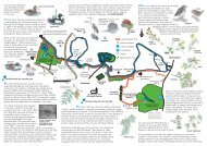
<strong><strong>Derby</strong>shire</strong> <strong>Area</strong> <strong>News</strong>—Winter 2012/13John King - <strong><strong>Derby</strong>shire</strong> Dales GroupFollowing on from the informative article by Sue Weatherley in the Summer <strong>Area</strong><strong>News</strong> which reminded readers of the delightful hills in the Upper Dove valley it is evidentthat very few ramblers are exploring the tracts of l<strong>and</strong> that have become accessiblesince implementation of the CROW Act. This is probably due to the fact that althoughdefined by perimeter boundaries on Explorer maps the access points <strong>and</strong> bestroutes are not commonly known. In this connection I have devised the following twocircular walks in order to encourage greater usage of eight of these hills, all of whichprovide superb views over the surrounding countryside. The narratives give detailedreference points <strong>and</strong> route directions for the uncharted areas to supplement the publicfootpath information shown on the White Peak map.Hartington – Longnor CircularFurther Adventures in Access L<strong>and</strong>This walk of about 11 miles enhances the popular Manifold <strong>and</strong> Dove valley round byproviding an alternative high level return leg with far reaching views throughout. FromHartington village duck pond proceed via public footpaths past the former cheese factory<strong>and</strong> over the westerly ridge to Sheen. Cross the road <strong>and</strong> take the most directpath to Brund to pick up the Manifold riverside path directly to Longnor. From Longnormarket place walk up Queen Street <strong>and</strong> continue straight ahead to the walled trackwhich climbs initially to a field before descending steeply past the sewage works toBeggars Bridge. Go straight on up Green Lane (ignoring the path to the right which isthe start of the low level Dove valley route back to Hartington). At the junction ofGreen Lane <strong>and</strong> the Crowdicote-Earl Sterndale road turn left for a short distance tothe access point to High Wheeldon on the right at GR09746611. The access waymarkon the stile points directly ahead up the steep slope which is a lung bursting route tothe summit. The easier way is to climb obliquely to the left initially towards Aldery Cliffto meet the lower slopes before turning right on to the gently ascending grassy ridgeto the Trig. Point. At 422 metres this gives a superb 360 degree panoramic view includingthe next section of access l<strong>and</strong> in a south easterly direction which provides ahigh level continuous stretch all stiled for over two miles. From the Trig. Point descendSE to the stile at GR10086598 <strong>and</strong> continue just below the wall to the next stile atGR10256571. The path then crosses a small dip before heading slightly downhill towardsa small wood on the right. Proceed on a level course about 40 yards above thewood <strong>and</strong> when the houses at Crowdicote come into view head downhill slightly to theexit gate at GR10346516 which is on the upper curve of the sharp S bend on theCrowdicote-High Needham road. Walk up the road about 50 yards to the access gateon the right to begin the next section.Head SE just below the wall initially before following two waymark posts across a dip<strong>and</strong> broken down wall to a ladder stile at GR10906485. Follow the direction arrowstraight on SE <strong>and</strong> below the ridge on a faint path through rough grassl<strong>and</strong>. At thesmall rocky outcrop in front take the path up to the left to the upper wall boundary <strong>and</strong>continue ahead ESE initially to follow a more distinct path line going up the forwardbank <strong>and</strong> beyond. When high above Pilsbury Castle climb up more steeply towards22
<strong><strong>Derby</strong>shire</strong> <strong>Area</strong> <strong>News</strong>—Winter 2012/13the upper boundary fence to a ladder stile at GR11716411. This is easily missed if youare too far down the slope. Over this stile the views to the east open up for a shortdistance prior to continuing below the ridge through a broken down wall; after whichthe path becomes more pronounced with waymark posts leading to the roadside exitgate alongside a concrete dew pond at GR12406367. Cross the metalled road (on thebend below Pilsbury Lodge) <strong>and</strong> take the signed public footpath S to Carder Low <strong>and</strong>onwards to return to Hartington. If desired, the walk can be shortened by confiningthe outward leg to Harris Close <strong>and</strong> the Dove valley via Pilsbury hamlet, Crowdicote<strong>and</strong> the footpath to the Green Lane junction mentioned previously.Hollinsclough Northern CircularThis relatively short walk of 8½ miles is nevertheless fairly strenuous as the summitsof six separate tracts of high level access l<strong>and</strong> are visited. The preferred direction isanti-clockwise in order to tackle the steepest climbs first although it could be reversedif preferred.From Hollinsclough village take one of the paths leading to the southern slopes ofParkhouse Hill. Contour round the lower slopes <strong>and</strong> where the path bifurcates take theleft fork direct to Glutton Grange, ignoring the signs on the way pointing upwards toaccess l<strong>and</strong>. Walk between the buildings at Glutton Grange to a track where straightahead there is a marked entry point to access l<strong>and</strong> at GR08386712 leading to theunnamed hill with a tumulus as marked on the map. Although of modest height it is asteepish climb so swing to the right initially before ascending the ridge to the tumuluscircle of stones. Head SSE down to the access point on the col leading to ParkhouseHill which is ascended by going straight ahead up the grassy slope to a slight dip onthe ridge. Turn right <strong>and</strong> follow the ridge path to the highest rocky outcrop to admirethe view. With Chrome Hill ahead descend on the ridge path which initially is on theleft of the ridge before switching to the right h<strong>and</strong> side. Take extra care on this path –a walking pole is particularly helpful. On approaching the final pinnacle <strong>and</strong> just beforethe path swings back to the left side of the ridge it is better to drop down the grassynorthern bank to the field below instead of following the path line which falls quitesteeply on the other side. Walk to the metalled road <strong>and</strong> turn right for the access pointto ascend the grassy slopes of Chrome Hill <strong>and</strong> the summit at 425 metres. ContinueNW on the ridge <strong>and</strong> descend to a concessionary path which climbs past Tor Rock toa boundary wall above Stoop farm.At the 3 way fingerpost above Stoop farm turn right over the cattle grid then immediatelyleft on the metalled road in the direction of High Edge for about 500 yards to acattle grid where there is a signed stile at GR06176870. The access l<strong>and</strong> of HighEdge is encircled by a superfluity of barbed wire fencing <strong>and</strong> hence access <strong>and</strong>egress is only possible at the stiles for the two public footpaths that cross the site.Looking ahead from the aforementioned stile High Edge has two separate summitseach having a distinctive concrete structure on top. These are well preserved WorldWar 2 pillboxes which were built in 1940 to counter enemy air attacks. Peak baggersmay wish to visit the southern pillbox first as this sits on a rocky promontory which at462 metres is the highest point of the walk. In this case walk from the stile alongsidethe adjacent wall <strong>and</strong> barbed wire fence to a small rocky outcrop directly ahead whichrises to the top of the wall. There is just enough room to manoeuvre round the end of23
<strong><strong>Derby</strong>shire</strong> <strong>Area</strong> <strong>News</strong>—Winter 2012/13the barbed wire to explore the pillbox <strong>and</strong> mound. Next proceed to the northern pillboxwhich sits on the site of a former cairn (yet still marked on the map) to obtain agr<strong>and</strong>st<strong>and</strong> view of High Edge Raceway <strong>and</strong> to Buxton <strong>and</strong> beyond. Head down theslope NW to the stile at GR05936925 to the right of the racetrack. Turn left on themetalled road <strong>and</strong> walk in front of the Raceway enclosure past the entrance gates <strong>and</strong>a cattle grid where there is a signed footpath at GR05556902.This path to the next hill runs SW initially alongside an untidy lime heap <strong>and</strong> fieldboundary wall over rough grassl<strong>and</strong> before turning 45 degrees right at a marker postto reach a dip on the near horizon where there is a farm gate <strong>and</strong> ladder stile. Overthe stile this unnamed access l<strong>and</strong> which is south of <strong>and</strong> contiguous with ThirkelowRocks has a small rocky peak with a marked spot height of 426 metres. The shortclimb to the summit gives another impressive all round view. Retrace your steps tothe ladder stile <strong>and</strong> drop down the fairly steep hillside SE to join the footpath fromThirkelow <strong>and</strong> head to Booth farm. Walk past the farm entrance <strong>and</strong> take the waymarkedbridleway towards Fough for about 50 yards to a marker post at GR05836798which is the start of the climb up left to the tumulus on Hollins Hill. Follow the waymarkedridge path on Hollins Hill which descends gradually before dropping down tore-join the footpath from Fough at GR06166703 to return to Hollinsclough.Another Pilgrim’s ProgressBarry Chapman (Erewash Group)Ten years ago, my friend Tony had walked the Camino de Santiago de Compostela –the pilgrimage across Northern Spain. This year he decided to do the walk again <strong>and</strong>asked me <strong>and</strong> another friend, Robin, to join him. Could I, aged 74, walk 800Km <strong>and</strong>be away from home for 6 weeks. This would be quite a challenge – <strong>and</strong> what a challengeit proved to be.Being a member of Erewash <strong>Ramblers</strong> for many years <strong>and</strong> also walking with Tony, Ihave walked in many areas of the UK <strong>and</strong> climbed the odd hill or two on the Isle ofMull but this would be my first long distance walk.We flew from Stansted Airport along with many other pilgrims, carrying rucksacks onthe flight. On arrival at Biarritz, we then caught the train that took us to the prettyFrench border town of St. Jean Pied de Port, the start of our chosen route which wasthe Camino Frances. There are various routes to Santiago from different startingpoints. One could start in Canterbury or Paris or many other cities in Europe as manypilgrims do.We rested in St. Jean for two days before embarking on our journey which in the firstthree days took us over the Pyrenees <strong>and</strong> its magnificent scenery <strong>and</strong> down to Pamplona.Tony had warned me this would be the hardest part of the journey <strong>and</strong> so itproved to be. My rucksack felt like a ton weight instead of its actual 11 kilos. With myfeet <strong>and</strong> leg muscles in agony, I wondered what I had let myself in for. But I had givenmyself this challenge. There was no going back.24
<strong><strong>Derby</strong>shire</strong> <strong>Area</strong> <strong>News</strong>—Winter 2012/13Each night we slept in Municiple Albergues (hostels). These consisted of bunk beds,showers <strong>and</strong> drying facilities. You are only allowed to stay in these hostels if you arewalking, cycling or on a donkey. We would start walking at about 6 a.m. before it becametoo hot, with the temperature on some days reaching up to 38 degrees.We met many nationalities along the way, all doing the pilgrimage for many differentreasons. Martin, from Germany, was doing the walk for his son who had leukaemia.Kelly was leading a group of young people from a theological college in the U.S.A. Allthe people we met had their own challenges, even the old man on the donkey <strong>and</strong> theblind man cycling on the t<strong>and</strong>em; so many interesting people along the way. We wouldmeet up in village bars for breakfast <strong>and</strong> then after checking in at the next albergue wewould have the Perigrino Menu del Dia in a nearby restaurant <strong>and</strong> share each other’sstories.Day after day the scenery was changing; from the mountains <strong>and</strong> the flat l<strong>and</strong>s offarms <strong>and</strong> vineyards interspersed with the cities of Logrono, Burgos <strong>and</strong> Leon withtheir amazing architecture. So, after 41 days, we arrived in Santiago <strong>and</strong> there receivedthe certificate to say we were officially Pilgrims of St. James. We went to thecathedral service for the blessing <strong>and</strong> to see the casket where the bones of St. Jamesare encased then on to celebrate with a pint or two in the square with the other pilgrims.We treated ourselves to a hotel for 3 nights <strong>and</strong> enjoyed this medieval city beforeflying home.We arrived back at Stansted with many blisters <strong>and</strong> aching limbs but overwhelmed bywhat we all had achieved. Such an experience. Such memories <strong>and</strong> stories to share.How many people can say they have had their feet bathed by a nun? I can.Detective Work in <strong>South</strong> <strong><strong>Derby</strong>shire</strong>Barry Thomas (D&SD Group)For the past two years I have been researching routes for a book of guided walks in<strong>South</strong> <strong><strong>Derby</strong>shire</strong>. The area south east of Burton on Trent is pleasant walking countryespecially around Walton on Trent <strong>and</strong> south of it all the way down to the Warwickshireborder. There are very few published routes in this area so I spent a lot of timestaring at the National Forest Explorer map trying to put routes together which lookedworthwhile by linking pretty villages <strong>and</strong> other places of interest.After looking at the map <strong>and</strong> investigating the area on the ground I realised that therewere practically no footpaths in the small rural parish of Catton which should be splendidwalking country. Catton is south of Walton-on-Trent <strong>and</strong> dominated today by CattonHall, a gr<strong>and</strong> 18 th century country house (though on a much older site). Poringover 19th century OS map I found that there were several paths in the parish includingone from Catton to Walton along the Trent. However, by the mid 20th century they hadgone; a trip to the <strong><strong>Derby</strong>shire</strong> Records Office at Matlock was therefore in order.Tracking down the information required was difficult especially since a mass of paperworkhad been transferred from the Rights of Way department at <strong><strong>Derby</strong>shire</strong> County25
<strong><strong>Derby</strong>shire</strong> <strong>Area</strong> <strong>News</strong>—Winter 2011/12 2012/13Council to the archives <strong>and</strong> has not been catalogued yet. I was looking for the recordsassociated with the 1949 National Parks <strong>and</strong> Access to Countryside Act. TheMatlock office has a folder for each <strong><strong>Derby</strong>shire</strong> parish containing correspondence <strong>and</strong>notes about footpaths from the early 1950s until the 1980s. There are also copies ofthe maps used by parish councils in 1950 to map their paths <strong>and</strong> the survey forms foreach footpath. The only information I have not been able to find are the records of theappeals meetings in which l<strong>and</strong>owners, ramblers <strong>and</strong> others involved could raise objectionsto the routes added to the draft Definitive Map.The details in the Catton folder were sparse but I was not surprised to see that the1949 survey paperwork had been filled in by the owner of Catton Hall, George HenryAnson, who was chairman of the parish meeting. This element was a weakness ofthe 1949 Act as the returns for local paths was usually carried out by the parish councilwhich in the post war period continued to be dominated by local l<strong>and</strong>owners whowere usually not keen to see footpaths going across their l<strong>and</strong>. And so this was thecase in Catton where three tiny footpaths were added (one more was added later bythe local surveyor) on the margin of the parish <strong>and</strong> none of them went anywhere nearthe attractive areas of the estate <strong>and</strong> house.I have found that owners of l<strong>and</strong>ed estates often describe footpaths close to theirproperties as “workmen’s routes” which had never been walked by any members ofthe public. I have come across this in other areas of the East Midl<strong>and</strong>s including IsleyWaklton <strong>and</strong> Buckminster in Leicestershire where the lords of the manor had tried toremove as many paths as they could from the map with a host of other excuses includingcalling them “hunting roads”. Further problems were caused when the parishcouncils sent their returns in the early 1950s to the County Councils which were dominatedor heavily influenced by the l<strong>and</strong>ed gentry. In <strong><strong>Derby</strong>shire</strong> these included theDuke of Devonshire (Chatsworth) <strong>and</strong> in Leicestershire, the Duke of Rutl<strong>and</strong>; bothhostile at the time to walkers.In the Catton folder of correspondence there were two intriguing letters (written in1966) involving a footpath that ran south of Catton to the Warwickshire border <strong>and</strong>beyond. The footpath was named after a 17th century poet who frequently stayed inthe area; it was known as Dryden’s Walk. The author of the letters wanted the Walkto be added to the Definitive Map <strong>and</strong> pointed out that the route was on a series ofOrdnance Survey maps even up until the 1950s.The author of the letters requested that contact be made with the County Archivist,whether this happened or not I cannot establish but a note on one of the lettersstates, “not on definitive, not claimed by parish, no reps (?)”. There is a further note inthe correspondence stating that the matter be left “for a rainy day” as they had other,more pressing things to deal with. The County Council surveyors department obviouslydid some work on the issue as there are further notes about the OS mapswhere this route was recorded. However, nothing came of the request <strong>and</strong> Dryden’sWalk was never added to the Definitive Map. Parts of it still seem to exist today <strong>and</strong>mention is made of it in several history books but certainly at the Catton end all signsof it have gone.Who was the writer of the letters to the County Council? Initially I was stumped asthey were sent from a location (perhaps a school) in Birmingham which no longer26
<strong><strong>Derby</strong>shire</strong> <strong>Area</strong> <strong>News</strong>—Winter 2012/13exists. The surname was unusual so I resorted to Google <strong>and</strong> found that the authorwas still active over footpath matters in the mid 2000s in, forty years later, the Coventryarea as a member of the Local <strong>Area</strong> Forum.You can imagine my surprise to discover that the author was OSS Local CorrespondentM. (Lionel) Menzler who is still active, I believe.Who knows, we might one day get part of Dryden’s Walk on the map!Trial Bikes <strong>and</strong> 4 x 4’s— an experience in Reporting IncidentsIf you think that Trial Bikers <strong>and</strong> ‘4 x 4’ problems are the preserve of the Peak Districtthen think again! Recently, whilst out pre-walking one of Dot Morson’s walks for the<strong>Area</strong> Get Together around Stanton Woods, Ticknall, we were buzzed by a couple ofTrial Bikes that clearly had no regards to the safety or well being of other users. Aftera couple of passes I stood my ground <strong>and</strong> managed to halt one of the joy riders. Nowit is very difficult to hold a reasonable conversation with an individual who’s head appearsto be as thick as the helmet it is wearing <strong>and</strong> who persists in revving the motorbikewith some gusto. However, I finally managed to get the message across that Ithought that motorised vehicles were not allowed on the path <strong>and</strong> could it please drivewith some consideration on it’s return. There was some sort of garbled comment thatalluded to it being OK to ride the path <strong>and</strong> it sped off causing spray that made muckspreading seem tame.After a few days, when I was able to get round to doing ‘the office’ bits, out of courtesyI let Dot know that the route was OK but we had come across the ‘things’ on motorbikes in an area I thought they should not be. Dot immediately sent my report to DCCwho quickly responded that, no the motor bikes should not be on the path <strong>and</strong> thebest thing to do would be report it to the Police <strong>and</strong> obtain an Incident Number.I rang 101 to be told, not unreasonably, that it should have been reported at the timeof the incident—fine. However, they would record it but would not now be able to investigateit—underst<strong>and</strong>able. I was then asked details of the incident. I related thestory <strong>and</strong> offered a grid reference to which came the reply that they needed a ROAD.I advised that, in <strong>South</strong> <strong><strong>Derby</strong>shire</strong> terms, we were in the middle of a forest in the middleof nowhere. After a bit of friendly banter we agreed on a ‘road‘ish’ location <strong>and</strong> Iwas rewarded with an incident number.Now, I have no problem with the reporting of the incident, the operator was polite <strong>and</strong>useful in our exchanges, indeed she perhaps thought what an idiot I was but refrainedfrom reminding me. BUT. How does one relate their position in the middle of nowhere<strong>and</strong> why aren’t grid references universally accepted yet by all agency service call centres?Any comments will be most welcome.VIEWPOINT27
<strong><strong>Derby</strong>shire</strong> <strong>Area</strong> <strong>News</strong>—Winter 2012/13DEALING WITH DANGEROUS DOGSKate Lee-D&SD Chair - has sent in this useful information for if you are ever confrontedby a less than friendly dog. One hopes that it will never happen but being aware ofhow to react is helpful—after all, unless you are comfortable with dogs, would youknow how to react?A few weeks ago I was contacted by a walker who had been attacked by a farmer’sdog (an Alsatian) on a local footpath. His companion had the presence of mind to puthis map holder in the dog’s mouth as it came to bite, which it dutifully did. With theproliferation of aggressive-type dogs as pets <strong>and</strong> dog attacks on the increase, it setme thinking about the best way to behave if ever faced with an aggressive dog.Here’s advice I’ve sourced from veterinary surgeons <strong>and</strong> the RSPCA.If a dog runs towards you but is not barking or growling, it may just be checkingyou out <strong>and</strong> after a quick sniff to determine you are no threat may leave you alone.St<strong>and</strong> still <strong>and</strong> let it sniff. Do not try to touch it, or make sudden movements, butspeak reassuringly. Keep st<strong>and</strong>ing still <strong>and</strong> it will lose interest <strong>and</strong> leave.If it is barking or growling, it considers you a threat <strong>and</strong> will be unlikely to leave.Study a dog's reaction to you. If it stiffens up, holds it tail high, snarls <strong>and</strong> stares atyou then be on your guard. If it shows its teeth it may be safest to go no further.Stop walking towards the dog. Stay calm (slow <strong>and</strong> deepen your breathing).Make no sudden movements: St<strong>and</strong> still <strong>and</strong> put your h<strong>and</strong>s in pockets becausethey like to get hold of something,Never run because the dog will always overtake you. Move away slowly <strong>and</strong>don't make any sudden movements. Do not turn your back, st<strong>and</strong> sidewayslooking slightly away watching the dog out of the corner of your eye.Avoid eye contact because it is confrontational. Don't approach the dog.Speak in a friendly, confident manner re-assuring the dog you mean no harm,to lessen the dog’s fear. Do not yell or scream or try to shoo the dog away.Stay on your feet <strong>and</strong> do not corner yourself.If the dog attacks fend off rather than fight back, put something between you<strong>and</strong> the dog i.e. a coat, walking stick, rucksack, map holder!If a dog does bite you, do not pull away because that will tear the flesh, butshout for help. If you or someone else can, slide something strong betweenthe jaws. (A walking stick seems ideal).28
<strong><strong>Derby</strong>shire</strong> <strong>Area</strong> <strong>News</strong>—Winter 2012/13Warning: Monitor any children as they can accidentally provoke a dog.Never ever try to separate dogs having a fight because of the risk of accidental <strong>and</strong>serious injury.Finally, dog attacks are still quite rare.A MAP READING LESSONWhilst members of the family have been the butt of my past comments onthis subject I have to admit to being well <strong>and</strong> truly caught out myself recently—<strong>and</strong> deservedly so. Following publication of the last edition I received anemail from a good colleague, John Straw (YJ), who claimed the prize forspotting the deliberate mistake. Now YJ enjoys nothing better than to banter,especially with Bill, an old friend of his who holds the dubious privilege ofawarding prizes to winners of our Group’s various contests, normally an ancientKit-Kat that is long past its sell-by-date. Taken aback, I responded that,sadly, there was no prize involved to which came the reply that I should thencheck through the publication. Now, having spent some considerable time inputting the edition together <strong>and</strong> innumerable proof reads, I was in no mood togo over it all again <strong>and</strong> so ignored the comment. Silly me! Along came anotherresponse that questioned my geographical awareness of the replacement‘Longhorse Bridge’ that was featured in the edition.AH! Red faced me. The text said it establishes a link along the Midshires Wayover the River Derwent which, to any self respecting member of the ErewashGroup knows full well should have read TRENT.So there, I admit my failings <strong>and</strong> apologise but YJ still wont get a prize. However,one thought remains—can SATNAV’s proof read? Apple ipad4 also takenote.29
<strong><strong>Derby</strong>shire</strong> <strong>Area</strong> <strong>News</strong>—Winter 2012/13Many thanks to everyone who contributed to this edition of <strong>Area</strong><strong>News</strong> <strong>and</strong> Annual Report. If you have a favourite walk, havecomment on any particular walking issues or snippets of newsyou wish to share then I would be pleased to hear from you. Articlescan be enhanced by photographs so please send those inas well.Which just leaves us now to wish all our members a HappyChristmas <strong>and</strong> Good Walking in the New YearOh!<strong>and</strong> don’t forget the AGMFinallyItems for the next <strong>Area</strong> <strong>News</strong> should reach me bySunday 21st April 2013 please.email: kashiers@tiscali.co.ukThe <strong>Ramblers</strong>’ Association is a company limited by guarantee, registered in Engl<strong>and</strong> <strong>and</strong> Wales.Company Reg. No. 4458492. Registered Charity in Engl<strong>and</strong> <strong>and</strong> Wales No. 1093577. Registeredoffice: 2nd Floor, Camelford House, 87-90 Albert Embankment, London SE1 7TW30
AREA OFFICERSElected at 2011 AGMPresident : John Beadle CBEVie-Presidents: Joy Osborne <strong>and</strong>Tony BeardsleyChairman <strong>and</strong> Publicity Secretary:Vacant<strong><strong>Derby</strong>shire</strong> <strong>Area</strong> <strong>News</strong>—Winter 2012/13Secretary:Martin PapeStable Grange, <strong>Derby</strong> Road,Cromford, Matlock DE4 3RP Tel. 01629 820265email: sec@derbyshireramblers.org.ukMembership Secretary:Chris Vaughan (see under <strong>Derby</strong> <strong>and</strong> <strong>South</strong> <strong><strong>Derby</strong>shire</strong>)Treasurer:Mike Huftonemail: general@ambervalleyramblers.org.ukContactsGROUP CONTACTSAmber ValleySecretary:Christine Levasseur,4 Lathkill Lane, Merebrook Park, Whatst<strong>and</strong>well,DE4 5NPEmail: groupsec@ambervalleyramblers.org.ukFootpaths Secretary:John Morrisey, 2 The Avenue, Belper DE56 1WB.Tel. 01773 825939<strong>Derby</strong> <strong>and</strong> <strong>South</strong> <strong><strong>Derby</strong>shire</strong>Secretary:Chris Vaughan, 3 Waterside Close, Darley Abbey,<strong>Derby</strong> DE22 1JTTel. 01332 558552email: sec@derbyramblers.org.ukFootpaths Secretary:David Varley, 27 Amber Road, Allestree, <strong>Derby</strong>DE22 2QBTel. 01332 551552email: footpaths@derbyramblers.org.ukFootpaths Secretary:Geof Cole(see under <strong><strong>Derby</strong>shire</strong> Dales opposite)Countryside Secretary:VacantAccess Officer:Sue Weatherley, Leahurst, Grove Place, YoulgreaveDE45 1UUemail: iweatherley@tiscali.co.ukMinutes Secretary:Carol Shiers, 10 Hazel Drive, Spondon,<strong>Derby</strong> DE21 7DSTel. 01332 665902email: kashiers@tiscali.co.uk<strong>Area</strong> <strong>News</strong> Editor:Keith Shiers, 10 Hazel Drive, Spondon, <strong>Derby</strong>DE21 7DSTel. 01332 665902email: kashiers@tiscali.co.uk<strong><strong>Derby</strong>shire</strong> DalesSecretary:Janet Keyne, 74 The Green Road, AshbourneDE6 1EETel. 01335 300340email: janetkeyne@googlemail.comFootpaths Secretary:Geof Cole,6 Buscot Drive, Ashbourne DE6 1JYTel. 01335 348336email: geof9241@yahoo.co.ukErewashSecretary:Tony Beardsley,14 York Avenue, S<strong>and</strong>iacre, Nottingham NG10 5HBTel. 0115 917 0082email: aebbooks@ntlworld.comFootpaths Secretary:Keith Shiers, 10 Hazel Drive, Spondon, <strong>Derby</strong>DE21 7DSTel. 01332 665902email: kashiers@tiscali.co.ukFamily GroupGreg Lunnemail: walk@derbyshirefamilyrambling.org.uk31