A printable version (Adobe PDF) - Derby and South Derbyshire ...
A printable version (Adobe PDF) - Derby and South Derbyshire ...
A printable version (Adobe PDF) - Derby and South Derbyshire ...
- No tags were found...

You also want an ePaper? Increase the reach of your titles
YUMPU automatically turns print PDFs into web optimized ePapers that Google loves.
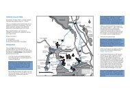
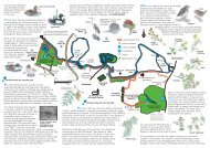
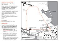
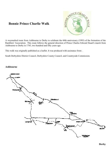
A contemporary Ashbourne resident wrote "On Tuesday 3rd December 1745, at night, the vanguard of therebels came from Leek to Ashbourne. They were in number 2000, horse <strong>and</strong> foot. On Wednesday morning theyproclaimed their Prince at the Market Cross, <strong>and</strong> then proceeded to <strong>Derby</strong>."For complete coverage <strong>and</strong> to add to the enjoyment of the walk you need three Ordnance Survey Pathfindermaps, 810 ( Ashbourne/ Churnet Valley), 811 (Belper), <strong>and</strong> 832 (<strong>Derby</strong>/Etwall). The walk starts in the<strong>Derby</strong>shire Dales, goes into <strong>South</strong> <strong>Derby</strong>shire, Amber Valley <strong>and</strong> finishes in the City of <strong>Derby</strong>.ASHBOURNE - LONGFORD (12 kms)The walk starts at the Market Cross in Ashbourne (point 1 on the map), goes downhill to the right into St John'sStreet. Turn right through the traffic lights into Church Street <strong>and</strong> go towards the church. Before the church turnleft down Station Road, past the swimming pool to the T-junction. Here turn left <strong>and</strong> almost immediatelyopposite is a finger post at North Leys which you follow up the steps in front. After crossing the first stile aimfor the radio mast <strong>and</strong> then take the track to the road opposite Peak View Drive.Take the right fork towards Wyaston as far as Willow Meadow Road where you turn left into the housing estatedown to Chestnut Drive. The path goes between no's 23 <strong>and</strong> 25, over a bridge <strong>and</strong> up the field to the newAshbourne by-pass. Cross to the caravan park <strong>and</strong> go straight across to a cattle grid leading to a wide trackthrough the field. At the edge of the wood bear right over a stile <strong>and</strong> a stream, <strong>and</strong> follow the edge of the woodto another stile. Cross the track leading to Blake House <strong>and</strong> climb over an obvious ladder stile into the field.Keep the hedge on your left until you enter a small plantation. Once out of the wood, aim for the left edge ofthe wood ahead, then at the corner keep the wood on your right until you come to a stile. Turn right onto theroad, <strong>and</strong> walk towards Osmaston Church, past the Shoulder of Mutton.At the village pond (point 2, notice the unusual horse-shoe bench), bear left <strong>and</strong> take the centre track marked"Bridle Path To Shirley". This is a delightful walk past the pool <strong>and</strong> the old sawmill to Shirley. Here there isanother public house, the Saracen's Head, opposite the church.From Shirley (point 3), continue ahead <strong>and</strong> take the right fork marked to Rodsley <strong>and</strong> Yeaveley. After 300metres, turn left onto a wide track immediately opposite the Wesleyan Chapel, built in 1855. This trackbecomes a bridleway, easy to follow, through some gates for 3.3kms to a track leading to Longford Church.Here, turn left down the track to <strong>South</strong> Lodge, on Long Lane, to Longford.
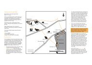
RADBOURNE - DERBY (9kms)The main walk continues from Radbourne (point 6) to <strong>Derby</strong> by staying on the road over a little bridge untilyou reach the finger post pointing diagonally across the field. Then walk uphill to the left of Silverhill Farmbuildings. Go over the stile in the hedge behind the oak tree <strong>and</strong> continue on the diagonal towards the gap in thehedge opposite. Now go to the left of the power line <strong>and</strong> follow it to the gate. Continue on this line to the stilein the corner by walking parallel to the hedge on the right. Cross this stile <strong>and</strong> keep the hedge on your left untilyou come to a bridge. After crossing, bear slightly left <strong>and</strong> go across two fields to the road, where you turn right<strong>and</strong> walk on the road as far as Station Road. Just beyond the junction turn left over a stile towards MackworthFields Farm <strong>and</strong> aim for the water tower in a copse <strong>and</strong> continue on this line down to the A52. Here turn right<strong>and</strong> almost immediately left at the Mackworth Hotel. Go down through a swing gate to the minor road whereyou turn right to Mackworth Church. The path leaves the churchyard on its eastern side <strong>and</strong> over the next threefields is clear to the road. Cross the road <strong>and</strong> take the walkway opposite leading to the garden centre <strong>and</strong> theentrance to Markeaton Park.Walk across the park with the lake on your left <strong>and</strong> head for the footbridge crossing the busy A38 trunk road.Cross <strong>and</strong> continue straight ahead, shortly afterwards reaching Markeaton Street. Continue to the junction withMackworth Road. Turn left, <strong>and</strong> at the bridge over Markeaton Brook turn right <strong>and</strong> follow the signpostedMarkeaton Brook Walkway. At a sheltered housing estate, temporarily part company with the brook, turn sharpleft <strong>and</strong> then right onto Mundy Street. At its junction with Nuns Street turn right <strong>and</strong> then left onto Mill Street.At the head of Mill Street is St John's church. Walk around the church onto Bridge Street <strong>and</strong> on the oppositeside of the road a signpost will direct you once again beside the brook towards the city centre.Cross the inner ring road at the traffic lights, past the clinic <strong>and</strong> the Queen's Leisure Centre <strong>and</strong> head towardsthe cathedral. At the traffic lights turn right into Irongate <strong>and</strong> down to the Market Place (point 7). This is theend of the walk, <strong>and</strong> well deserved refreshments are available at many nearby hostelries, some 8 hours,allowing for rests, after leaving Ashbourne!Radbourne - The Square, Mickleover (3kms)Leave the churchyard at Radbourne (point 6) by the gate, <strong>and</strong> climb over the stile into Radbourne Park. Followthe drive for a short distance, climb the hill bearing left, <strong>and</strong> passing in front of a coppice, to a stile <strong>and</strong>footbridge <strong>and</strong> onto the road. Opposite you, a stile leads into a field. Cross this field <strong>and</strong> the next three fields, tothe dismantled railway line, <strong>and</strong> you will eventually emerge in Greenside Court. Turn right, <strong>and</strong> follow
Distance / Time - Walking time onlyAshbourne Osmaston Shirley Longford Lees Radbourne <strong>Derby</strong>Time, hours 1 1.75 3 4.25 4.75 7Distance, km. 4 7 12 17 19 28Distance, miles 2.5 4.4 7.5 10.6 11.8 17.7MickleoverTime,hours5.5Distance,km.22Distance,miles13.7The Ramblers Association cannot accept any responsibility for any loss or injury sustained by persons takingpart in this walk.Illustrations by Geoff Lightbown