A printable version (Adobe PDF) - Derby and South Derbyshire ...
A printable version (Adobe PDF) - Derby and South Derbyshire ...
A printable version (Adobe PDF) - Derby and South Derbyshire ...
- No tags were found...

Create successful ePaper yourself
Turn your PDF publications into a flip-book with our unique Google optimized e-Paper software.
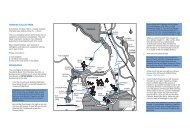
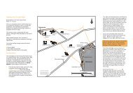
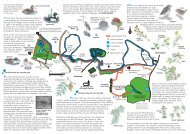
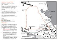
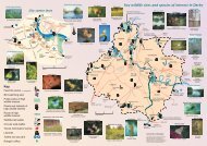
A contemporary Ashbourne resident wrote "On Tuesday 3rd December 1745, at night, the vanguard of therebels came from Leek to Ashbourne. They were in number 2000, horse <strong>and</strong> foot. On Wednesday morning theyproclaimed their Prince at the Market Cross, <strong>and</strong> then proceeded to <strong>Derby</strong>."For complete coverage <strong>and</strong> to add to the enjoyment of the walk you need three Ordnance Survey Pathfindermaps, 810 ( Ashbourne/ Churnet Valley), 811 (Belper), <strong>and</strong> 832 (<strong>Derby</strong>/Etwall). The walk starts in the<strong>Derby</strong>shire Dales, goes into <strong>South</strong> <strong>Derby</strong>shire, Amber Valley <strong>and</strong> finishes in the City of <strong>Derby</strong>.ASHBOURNE - LONGFORD (12 kms)The walk starts at the Market Cross in Ashbourne (point 1 on the map), goes downhill to the right into St John'sStreet. Turn right through the traffic lights into Church Street <strong>and</strong> go towards the church. Before the church turnleft down Station Road, past the swimming pool to the T-junction. Here turn left <strong>and</strong> almost immediatelyopposite is a finger post at North Leys which you follow up the steps in front. After crossing the first stile aimfor the radio mast <strong>and</strong> then take the track to the road opposite Peak View Drive.Take the right fork towards Wyaston as far as Willow Meadow Road where you turn left into the housing estatedown to Chestnut Drive. The path goes between no's 23 <strong>and</strong> 25, over a bridge <strong>and</strong> up the field to the newAshbourne by-pass. Cross to the caravan park <strong>and</strong> go straight across to a cattle grid leading to a wide trackthrough the field. At the edge of the wood bear right over a stile <strong>and</strong> a stream, <strong>and</strong> follow the edge of the woodto another stile. Cross the track leading to Blake House <strong>and</strong> climb over an obvious ladder stile into the field.Keep the hedge on your left until you enter a small plantation. Once out of the wood, aim for the left edge ofthe wood ahead, then at the corner keep the wood on your right until you come to a stile. Turn right onto theroad, <strong>and</strong> walk towards Osmaston Church, past the Shoulder of Mutton.At the village pond (point 2, notice the unusual horse-shoe bench), bear left <strong>and</strong> take the centre track marked"Bridle Path To Shirley". This is a delightful walk past the pool <strong>and</strong> the old sawmill to Shirley. Here there isanother public house, the Saracen's Head, opposite the church.From Shirley (point 3), continue ahead <strong>and</strong> take the right fork marked to Rodsley <strong>and</strong> Yeaveley. After 300metres, turn left onto a wide track immediately opposite the Wesleyan Chapel, built in 1855. This trackbecomes a bridleway, easy to follow, through some gates for 3.3kms to a track leading to Longford Church.Here, turn left down the track to <strong>South</strong> Lodge, on Long Lane, to Longford.