Derbyshire Area News - Derby and South Derbyshire Ramblers
Derbyshire Area News - Derby and South Derbyshire Ramblers
Derbyshire Area News - Derby and South Derbyshire Ramblers
- No tags were found...

Create successful ePaper yourself
Turn your PDF publications into a flip-book with our unique Google optimized e-Paper software.
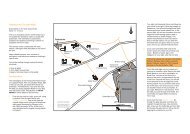
<strong><strong>Derby</strong>shire</strong> <strong>Area</strong> <strong>News</strong>—Winter 2012/13John King - <strong><strong>Derby</strong>shire</strong> Dales GroupFollowing on from the informative article by Sue Weatherley in the Summer <strong>Area</strong><strong>News</strong> which reminded readers of the delightful hills in the Upper Dove valley it is evidentthat very few ramblers are exploring the tracts of l<strong>and</strong> that have become accessiblesince implementation of the CROW Act. This is probably due to the fact that althoughdefined by perimeter boundaries on Explorer maps the access points <strong>and</strong> bestroutes are not commonly known. In this connection I have devised the following twocircular walks in order to encourage greater usage of eight of these hills, all of whichprovide superb views over the surrounding countryside. The narratives give detailedreference points <strong>and</strong> route directions for the uncharted areas to supplement the publicfootpath information shown on the White Peak map.Hartington – Longnor CircularFurther Adventures in Access L<strong>and</strong>This walk of about 11 miles enhances the popular Manifold <strong>and</strong> Dove valley round byproviding an alternative high level return leg with far reaching views throughout. FromHartington village duck pond proceed via public footpaths past the former cheese factory<strong>and</strong> over the westerly ridge to Sheen. Cross the road <strong>and</strong> take the most directpath to Brund to pick up the Manifold riverside path directly to Longnor. From Longnormarket place walk up Queen Street <strong>and</strong> continue straight ahead to the walled trackwhich climbs initially to a field before descending steeply past the sewage works toBeggars Bridge. Go straight on up Green Lane (ignoring the path to the right which isthe start of the low level Dove valley route back to Hartington). At the junction ofGreen Lane <strong>and</strong> the Crowdicote-Earl Sterndale road turn left for a short distance tothe access point to High Wheeldon on the right at GR09746611. The access waymarkon the stile points directly ahead up the steep slope which is a lung bursting route tothe summit. The easier way is to climb obliquely to the left initially towards Aldery Cliffto meet the lower slopes before turning right on to the gently ascending grassy ridgeto the Trig. Point. At 422 metres this gives a superb 360 degree panoramic view includingthe next section of access l<strong>and</strong> in a south easterly direction which provides ahigh level continuous stretch all stiled for over two miles. From the Trig. Point descendSE to the stile at GR10086598 <strong>and</strong> continue just below the wall to the next stile atGR10256571. The path then crosses a small dip before heading slightly downhill towardsa small wood on the right. Proceed on a level course about 40 yards above thewood <strong>and</strong> when the houses at Crowdicote come into view head downhill slightly to theexit gate at GR10346516 which is on the upper curve of the sharp S bend on theCrowdicote-High Needham road. Walk up the road about 50 yards to the access gateon the right to begin the next section.Head SE just below the wall initially before following two waymark posts across a dip<strong>and</strong> broken down wall to a ladder stile at GR10906485. Follow the direction arrowstraight on SE <strong>and</strong> below the ridge on a faint path through rough grassl<strong>and</strong>. At thesmall rocky outcrop in front take the path up to the left to the upper wall boundary <strong>and</strong>continue ahead ESE initially to follow a more distinct path line going up the forwardbank <strong>and</strong> beyond. When high above Pilsbury Castle climb up more steeply towards22