Impact Assessment of Climate Change and Sea Level Rise on ...
Impact Assessment of Climate Change and Sea Level Rise on ...
Impact Assessment of Climate Change and Sea Level Rise on ...

Create successful ePaper yourself
Turn your PDF publications into a flip-book with our unique Google optimized e-Paper software.
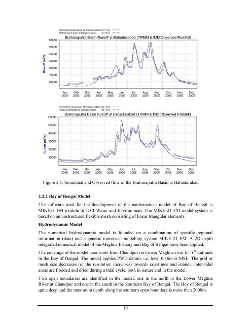
Run<str<strong>on</strong>g>of</str<strong>on</strong>g>f (m 3 /s)<br />
Run<str<strong>on</strong>g>of</str<strong>on</strong>g>f (m 3 /s)<br />
Figure 2.1: Simulated <str<strong>on</strong>g>and</str<strong>on</strong>g> Observed flow <str<strong>on</strong>g>of</str<strong>on</strong>g> the Brahmaputra Basin at Bahadurabad<br />
2.2.2 Bay <str<strong>on</strong>g>of</str<strong>on</strong>g> Bengal Model<br />
The s<str<strong>on</strong>g>of</str<strong>on</strong>g>tware used for the development <str<strong>on</strong>g>of</str<strong>on</strong>g> the mathematical model <str<strong>on</strong>g>of</str<strong>on</strong>g> Bay <str<strong>on</strong>g>of</str<strong>on</strong>g> Bengal is<br />
MIKE21 FM module <str<strong>on</strong>g>of</str<strong>on</strong>g> DHI Water <str<strong>on</strong>g>and</str<strong>on</strong>g> Envir<strong>on</strong>ment. The MIKE 21 FM model system is<br />
based <strong>on</strong> an unstructured flexible mesh c<strong>on</strong>sisting <str<strong>on</strong>g>of</str<strong>on</strong>g> linear triangular elements.<br />
Hydrodynamic Model<br />
The numerical hydrodynamic model is founded <strong>on</strong> a combinati<strong>on</strong> <str<strong>on</strong>g>of</str<strong>on</strong>g> specific regi<strong>on</strong>al<br />
informati<strong>on</strong> (data) <str<strong>on</strong>g>and</str<strong>on</strong>g> a generic numerical modelling system MIKE 21 FM. A 2D depth<br />
integrated numerical model <str<strong>on</strong>g>of</str<strong>on</strong>g> the Meghna Estuary <str<strong>on</strong>g>and</str<strong>on</strong>g> Bay <str<strong>on</strong>g>of</str<strong>on</strong>g> Bengal have been applied.<br />
The coverage <str<strong>on</strong>g>of</str<strong>on</strong>g> the model area starts from Ch<str<strong>on</strong>g>and</str<strong>on</strong>g>pur <strong>on</strong> Lower Meghna river to 16 0 Latitude<br />
in the Bay <str<strong>on</strong>g>of</str<strong>on</strong>g> Bengal. The model applies PWD datum, i.e. level 0.46m is MSL. The grid or<br />
mesh size decreases (or the resoluti<strong>on</strong> increases) towards coastlines <str<strong>on</strong>g>and</str<strong>on</strong>g> isl<str<strong>on</strong>g>and</str<strong>on</strong>g>s. Inter-tidal<br />
areas are flooded <str<strong>on</strong>g>and</str<strong>on</strong>g> dried during a tidal cycle, both in nature <str<strong>on</strong>g>and</str<strong>on</strong>g> in the model.<br />
Two open boundaries are identified in the model, <strong>on</strong>e in the north in the Lower Meghna<br />
River at Ch<str<strong>on</strong>g>and</str<strong>on</strong>g>pur <str<strong>on</strong>g>and</str<strong>on</strong>g> <strong>on</strong>e in the south in the Southern Bay <str<strong>on</strong>g>of</str<strong>on</strong>g> Bengal. The Bay <str<strong>on</strong>g>of</str<strong>on</strong>g> Bengal is<br />
quite deep <str<strong>on</strong>g>and</str<strong>on</strong>g> the maximum depth al<strong>on</strong>g the southern open boundary is more than 2000m.<br />
19