Severnway - South Gloucestershire Council
Severnway - South Gloucestershire Council
Severnway - South Gloucestershire Council

Create successful ePaper yourself
Turn your PDF publications into a flip-book with our unique Google optimized e-Paper software.
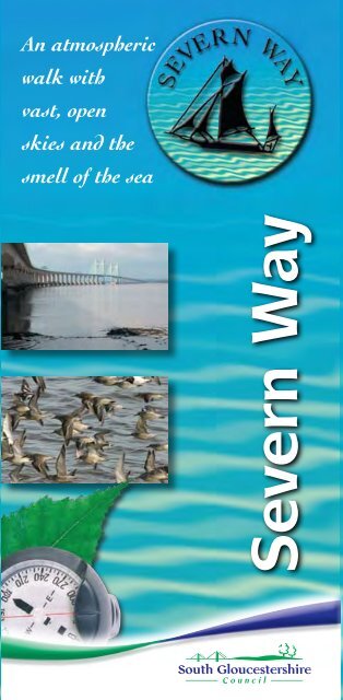
An atmospheric<br />
walk with<br />
vast, open<br />
skies and the<br />
smell of the sea<br />
Severn Way
M4<br />
Map 4<br />
Severn<br />
Beach<br />
<br />
Map 3<br />
M49<br />
M48<br />
Pilning<br />
R i v e r<br />
M5<br />
Aust<br />
Map 2<br />
S e v e<br />
Littleton<br />
-on-<br />
Severn<br />
Almondsbury<br />
R<br />
r n<br />
iver Frome<br />
Map 1<br />
B r i s t o l<br />
Oldbury<br />
-on-<br />
Severn<br />
Olveston<br />
Bradley<br />
Stoke<br />
Tockington<br />
M32<br />
Map 6<br />
Map 5<br />
Alveston<br />
River Avon<br />
Thornbury<br />
S o u t h G l<br />
Downend<br />
Kingswood<br />
M5<br />
Coalpit<br />
Heath<br />
Bitton<br />
Tytherington<br />
Iron<br />
Acton<br />
Reproduced from the Ordnance Survey mapping with the permission of the Controller of Her Majesty’s Office Crown Copyright.<br />
Unauthorised reproduction infringes Crown copyright and may lead to prosecution or civil proceedings. © Crown Copyright. All rights reserved. <strong>South</strong> <strong>Gloucestershire</strong> <strong>Council</strong> LA100023410/2009<br />
‘The Ordnance Survey mapping within this publication is provided by <strong>South</strong> <strong>Gloucestershire</strong> <strong>Council</strong> under licence from the Ordnance Survey in order to fulfil its public function to publicise local public services.<br />
Persons viewing this mapping should contact Ordnance Survey Copyright for advice where they wish to licence Ordnance Survey mapping for their own use.’<br />
Wick<br />
Charfield<br />
Yate<br />
Pucklechurch<br />
Wickwar<br />
o u c e s t e<br />
Chipping<br />
Sodbury<br />
M4<br />
r s h i r<br />
e<br />
<br />
Tormarton<br />
s w<br />
C o t<br />
o l d<br />
Marshfield<br />
s A<br />
<br />
<br />
<br />
<br />
<br />
<br />
<br />
<br />
<br />
<br />
<br />
B<br />
O N<br />
<br />
<br />
<br />
<br />
<br />
<br />
<br />
<br />
<br />
<br />
Bus Services<br />
Rail and Bus Services serving the <strong>South</strong><br />
<strong>Gloucestershire</strong> Section of the Severn Way<br />
Rail or Bus Stops near<br />
the Severn Way<br />
Aust Motorway Roundabout<br />
Thornbury Health Centre<br />
Thornbury Health Centre,<br />
Lower Morton,<br />
Rockhampton, Nupdown,<br />
Oldbury, Shepperdine<br />
Thornbury Health Centre,<br />
Aust Motorway Roundabout,<br />
Aust Village, Northwick,<br />
Severn Beach Station<br />
Thornbury Health Centre,<br />
Castle School<br />
Thornbury Health Centre<br />
Service<br />
X11 Bristol - Chepstow<br />
X14 Bristol - Newport<br />
309 Bristol - Thornbury<br />
310 Bristol - Dursley<br />
613 Oldbury - Thornbury<br />
614 Severn Beach - Thornbury<br />
615 Thornbury Town Service<br />
622 Cribbs Causeway - Thornbury<br />
Chipping Sodbury<br />
Redwick, 625 UWE - Bristol Parkway -<br />
Severn Beach Station Severn Beach<br />
Thornbury Health Centre 201 Thornbury -<br />
Wotton-under-Edge - Gloucester<br />
Thornbury Fire Station 207 Thornbury - Berkley -<br />
Gloucester<br />
Severn Beach Station Train Bristol Temple Meads -<br />
Severn Beach<br />
For details on service frequency and<br />
days of operation phone Traveline on<br />
0871 200 22 33. (calls cost 10p per<br />
minute from a landline) or plan your<br />
journey at www.traveline.info<br />
Services are subject to change so you should always check with<br />
Traveline before setting off.<br />
Certain services are provided with financial support from<br />
<strong>South</strong> <strong>Gloucestershire</strong> <strong>Council</strong>.<br />
The Severn Way<br />
33
Key for Route Maps<br />
<br />
<br />
<br />
<br />
<br />
<br />
<br />
<br />
<br />
<br />
<br />
<br />
<br />
<br />
<br />
<br />
<br />
<br />
<br />
<br />
<br />
<br />
M
Introduction<br />
The Severn Walk is a long distance walk of<br />
around 337km (210 miles) that follows the<br />
river from its source at Plynlimon in the Welsh<br />
mountains to its mouth in the Severn<br />
Estuary. This booklet describes<br />
the 21km (12.5 mile) section of<br />
the Severn Way which lies in<br />
<strong>South</strong> <strong>Gloucestershire</strong>,<br />
exploring the estuary and<br />
lower reaches of the River<br />
Severn from Severn Beach to<br />
Hill, just north of Oldbury Power<br />
Station.<br />
The Thornbury Link is a route joining the Severn Way<br />
with the market town of Thornbury, and is included in<br />
this booklet. Other footpaths that join the Severn Way<br />
are also shown on the maps, to help you plan circular<br />
walks if required.<br />
Tidal salt marsh and mud flats at Northwick Warth<br />
@ Sharper Image Photography<br />
The Severn Way 1
The Severn Walk<br />
What kind of walking to expect<br />
This is comfortable walking, along the lower reaches<br />
of the River Severn and its estuary. There are no<br />
steep inclines and much of the route is on top of the<br />
river bank, with wonderful wide open views over the<br />
river to the Forest of Dean and up the Severn Vale<br />
towards the Cotswold Hills. However, the route can<br />
be chilly as it is open to the winds that often blow up<br />
the Bristol Channel from the Atlantic Ocean, so make<br />
sure that you have enough warm clothes!<br />
The river is tidal in this section, and can be liable to<br />
flooding at high tides and after heavy rain. Keep to<br />
the way-marked route and avoid walking out onto any<br />
of the mud and sand banks, especially at low tide, as<br />
they can conceal hidden gulleys and quicksand.<br />
Public transport, inns and cafés<br />
This section of the Severn Way is well served by<br />
public transport. There is a regular train service to<br />
Severn Beach from Bristol Temple Meads<br />
(www.severnbeachline.org) and a network of bus<br />
services serve the towns and villages along the Severn<br />
Vale. More details of public transport services are<br />
given on the inside back cover of this booklet.<br />
There are various inns and cafés and these are all<br />
marked on the route maps enclosed.<br />
Sharing the Severn estuary – its wildlife and<br />
you<br />
The Severn Estuary has over 50,000<br />
winter visitors from all over the world –<br />
they are all birds! Disturbance from<br />
some land and water based recreation<br />
can affect over wintering birds. They are<br />
particularly vulnerable when the weather<br />
is cold. Disturbing them means they<br />
have difficulty feeding at a time when<br />
they most need to.<br />
You can help protect our winter visitors and encourage<br />
them to return by:<br />
● Keeping to public footpaths.<br />
● Keeping dogs under close control (especially on saltmarsh<br />
and coastal areas where birds are feeding).<br />
● Avoiding sites which you know are used by birds at<br />
certain times of the year and sates of tide.<br />
● Taking your litter home.<br />
● Keeping noise to a minimum, both on shore and on<br />
the water (birds are sensitive to noise and<br />
disturbance).<br />
● Avoiding damage to saltmarsh.<br />
● Always following your activity’s national codes of<br />
conduct where available.<br />
Enjoy the estuary, and please be considerate about the<br />
wildlife you share with it. If you are interested in the<br />
wildlife, or any other estuary issues, please contact the<br />
Severn Estuary Partnerhship.<br />
Tel 029 20 874713, or go to<br />
www.severnestuary.net/sep<br />
2<br />
The Severn Way<br />
3
An exhilarating walk where<br />
the river meets the sea...<br />
The magnificent Severn<br />
The majestic Severn is Britain’s longest river and forms<br />
part of the border between England and Wales. It’s a<br />
huge, powerful river, over two miles wide in places,<br />
and is known locally as the Severn Sea. It really does<br />
have a maritime feel about it, with the smell of the<br />
sea, gulls calling and pieces of seaweed along the<br />
banks. The river looks very different according to the<br />
state of the tide. At high tide, it’s full to the brim, and<br />
is often choppy with waves breaking on the shore. At<br />
low tide vast stretches of sand and mud are revealed,<br />
gleaming with water and teeming with thousands of<br />
feeding waders and wildfowl in the winter months.<br />
For all its awesome beauty, the Severn can be a<br />
treacherous river as well. It often looks slow moving<br />
and calm, but the reality is very different - despite its<br />
impressive width, parts of the river are fast-flowing<br />
with strong currents, quicksand and shifting<br />
shallows. On a rising tide the river fills at a<br />
tremendous rate, rising more than two metres in<br />
under an hour in places.<br />
The lonely sea and the sky<br />
The River Severn is only a few miles away from the<br />
thriving city of Bristol, but it’s a completely different<br />
world out by the river and estuary, with open skies,<br />
the wind blowing in from the Atlantic and hundreds of<br />
birds for company. It is a landscape of contrasts, with<br />
the two engineering masterpieces of the Severn<br />
Bridges, tall cliffs and secret salt marshes, power<br />
stations and historic inns, isolated farms. The Severn<br />
Way is an attractive walk at any time of the year, but it<br />
is perhaps at its most exhilarating in winter, when low<br />
sunlight gives the water a silvery sheen and flocks of<br />
wild birds slice through the huge skies overhead.<br />
Trading ports and trows<br />
At one time, the Severn was Britain’s busiest river, full<br />
of boats carrying people and cargo up, down and<br />
across the river. The ancient ports of Chepstow and<br />
Newport were bustling and busy in medieval times, as<br />
was Bristol, which was the major port on the estuary<br />
long before it began its lucrative trade with the New<br />
World in the fifteenth century. Severn trows were one<br />
of the most common boats, specially designed for the<br />
sailing conditions of the Severn, with a flat bottom to<br />
let them sail over sandbanks if necessary. An image<br />
of a Severn trow is depicted on the Severn Way<br />
waymarker.<br />
View towards the first Severn Suspension Bridge<br />
Way Marker<br />
4<br />
The Severn Way<br />
5
A powerful river<br />
The Severn is an extremely powerful river,<br />
with hundreds of millions of litres of water,<br />
carrying huge amounts of silt as it moves<br />
downstream. The estuary has the highest tidal range<br />
in Europe (and second highest in the world) with a<br />
difference in height of more than 11 metres between<br />
high and low tide. The lower reaches of the river are<br />
strongly tidal, right up to Gloucester, over 30 miles<br />
upstream of the Severn Bridge.<br />
Water energy<br />
People have been thinking of ways of using the power<br />
of the river and the estuary for many years.<br />
A Severn Barrage was first suggested back in the<br />
1840’s, to raise the water level of the estuary to<br />
benefit shipping. More recently the Government<br />
Department of Energy and Climate Change has begun<br />
to investigate harnessing the tidal power of the<br />
estuary to generate electricity. No decisions have been<br />
made yet, but a series of detailed feasibility studies<br />
are being carried out to assess the likely impact of the<br />
proposals on estuary wildlife and ecology, the local<br />
communities and the region’s wider economy and<br />
environment.<br />
The two nuclear power stations at Oldbury and<br />
Berkeley (now closed) have also made use of the river,<br />
although in a different way. They use river water to<br />
cool the steam from the turbines that generate<br />
electricity.<br />
Severn Bore<br />
The Severn Bore is a tidal wave that makes its way up<br />
the river several times a month. It happens<br />
during the highest or spring tides, when the water<br />
from the Bristol Channel is funnelled up the river by<br />
the incoming tide. The rising tide sweeps up the lower<br />
reaches of the river as a wall of water, overpowering<br />
the river water flowing downstream, and forming a<br />
large wave that rushes noisily upstream. The height of<br />
the wave, or bore, depends on the width and depth of<br />
the river, as well as the height and power of the<br />
incoming tide, and the weather. The tapering shape of<br />
the estuary and the large tidal range makes the Severn<br />
Bore the largest in Britain. Bores over 2m high have<br />
been recorded, travelling upstream at speeds up to<br />
12mph, depending on local conditions. Small-scale<br />
bores occur throughout the year, but the largest ones<br />
only happen on about 25 days of the year, peaking in<br />
March and September at the time of the spring and<br />
autumn equinoxes.<br />
The best places to<br />
see the Bore are<br />
further upstream at<br />
Newnham,<br />
Minsterworth and<br />
Stonebench, where<br />
the estuary narrows<br />
Surfing the Severn Bore (Tim Cooper)<br />
as it approaches<br />
Gloucester. The bore now regularly attracts large<br />
groups of surfers who compete to see who can ride<br />
the wave the furthest. To find out more, and to check<br />
the Bore timetable, go to www.severn-bore.co.uk.<br />
Oldbury Power Station<br />
6<br />
The Severn Way<br />
7
A river of passage<br />
Like all rivers, the Severn is a river of<br />
passage. People have travelled over and along<br />
the river for thousands of years, using boats,<br />
ferries, steamboats and paddle-steamers as well as<br />
the two motorway crossings over the Severn.<br />
There is even a<br />
route under the<br />
river, along the<br />
Severn Tunnel that<br />
carries passenger<br />
and goods trains<br />
between Bristol and<br />
Severn Tunnel entrance at Severn Beach <strong>South</strong> Wales.<br />
Teeming with wildlife<br />
The Severn is famous for the passage of wildlife,<br />
especially fish and birds, which use the estuary as a<br />
feeding station on their annual migration routes.<br />
The huge mudflats, gravel beds and sand bars of the<br />
Welsh Grounds and Bedwin, Oldbury and Shepperdine<br />
Sands are some of the most important feeding<br />
grounds in Britain. During the winter, there can be<br />
huge numbers of ducks, geese and wader birds<br />
feeding on millions of burrowing worms and snails<br />
that live in the mud of the estuary. The sight and<br />
sound of thousands of birds wheeling and turning in<br />
the sky as they get ready to settle at a roost is one of<br />
the most spectacular sights of the Severn Estuary.<br />
Gourmet treats<br />
Severn salmon and eels have been famous local food<br />
delicacies for centuries, and many of the riverside<br />
villages have grown as a result of their fishing.<br />
Fisheries are known to have existed on the Severn in<br />
Saxon times and, down the centuries, a unique<br />
fishing tool, known as a putcher, has been used to<br />
catch salmon. Putchers are conical baskets, which are<br />
set out on the banks of the estuary in winter. As the<br />
salmon swim upstream to spawn, the turbulent and<br />
muddy water makes it almost impossible for the fish<br />
to see and they swim blindly into the open mouths of<br />
the putchers and quickly drown as they get wedged in<br />
the narrowing basket. The remains of old rows of<br />
salmon putchers can be seen at low tide in places,<br />
stretching out into the water along the banks of the<br />
river.<br />
Walking over the river<br />
Amazingly, the Severn has also been a crossing route<br />
for walkers, riders and cattle over the centuries. In<br />
the past, there were routes across the river, known<br />
mainly to local people, which could be safely<br />
navigated on horseback or by wading between the<br />
treacherous shifting sandbars and gravel beds.<br />
There are stories of the Romans fording the river, as<br />
well as tales of cattle being herded over the river at<br />
low tide, to shorten their journey to market.<br />
Nowadays it is much safer and easier to use the<br />
walkway on the old Severn Bridge, which offers<br />
walkers and cyclists a dry and spectacular route over<br />
the river! There is no path or cycleway on the second<br />
Severn bridge.<br />
8<br />
The Severn Way<br />
9
SECTION 1 (See Map 1)<br />
<strong>South</strong> <strong>Gloucestershire</strong> Border<br />
to Oldbury Power Station<br />
Oldbury Power Station has been in operation<br />
since 1967. It’s a Magnox station and its twin<br />
reactors produce enough electricity to supply a city<br />
about one and a half times the size of Bristol. Like<br />
most power stations, Oldbury is built next to a large<br />
water supply, because it needs huge amounts of water<br />
to cool the steam from the turbines. When it’s<br />
running at full power, Oldbury needs about 70<br />
million litres of water per hour. There’s a large tidal<br />
reservoir on the eastern bank of the river to make sure<br />
that there’s a continuous supply of water<br />
available for the station, whatever the state of the<br />
tide. You can see the triangular-shaped reservoir at<br />
low tide, but at high tide it is covered by water.<br />
The Windbound at Shepperdine<br />
The former Windbound inn got its name from a<br />
traditional mariner’s excuse. Severn bargees, having<br />
had a few drinks too many, tended to blame local<br />
weather conditions for their reluctance to get back to<br />
work on their boats.<br />
Their habit of telling their employers that they<br />
were ‘wind-bound’ was so widespread that the inn<br />
changed its name from the New Inn to the<br />
Windbound. The in now closed and a private<br />
residence<br />
Oldbury Power Station Nature Trail is 2 km<br />
long and links with the Severn Way. It gives a vivid<br />
and living introduction to the wide range of wildlife<br />
which thrive around the grounds of the Power Station.<br />
There are nature trail leaflets available in the car park<br />
by the Power Station and interpretative boards placed<br />
around the trail. The area of wildlife habitat<br />
comprises grass meadows, hedgerows, reed beds, an<br />
orchard, freshwater ponds and silt lagoons.<br />
Please keep to the marked paths and stay off<br />
the lagoon surface.<br />
Saltmarsh at Northwick Warth<br />
Lapwing (Paul Bowerman)<br />
Oldbury Power Station and silt lagoons<br />
10<br />
The Severn Way<br />
11
MAP 1<br />
<strong>South</strong> <strong>Gloucestershire</strong> Border to Oldbury Power Station<br />
View to Oldbury<br />
Power Station & the<br />
Tidal Reservoir<br />
12<br />
© Crown Copyright. All rights reserved. <strong>South</strong> <strong>Gloucestershire</strong> <strong>Council</strong> 100023410, 2009.<br />
The Severn Way 13
SECTION 2 (See Maps 2 & 3)<br />
Oldbury Power Station to<br />
Severn Bridge Services<br />
Oldbury-on-Severn<br />
This former salmon fishing village is tucked away more<br />
than half a mile from the Severn, between two<br />
monuments to 1960’s technology - Oldbury Power<br />
Station and the original older Severn Suspension<br />
Bridge. The names of the two inns, The Ship and The<br />
Anchor, reflect<br />
the village’s long<br />
history as a busy<br />
Severn port,<br />
when men from<br />
the coastal<br />
villages manned<br />
The Ship Inn at Oldbury-on-Severn the fishing boats<br />
and trows which<br />
plied their trade around the estuary and along the<br />
river. The village is at the end of a small inlet called<br />
Oldbury Pill, which is now the base for the local sailing<br />
club. St Arilda’s church is separate from the village,<br />
built in a prominent position on the top of Cow Hill.<br />
The church was whitewashed in the eighteenth<br />
century, to serve as a landmark for sailors on the<br />
Severn.<br />
a potentially dangerous crossing. Over the centuries<br />
numerous boats are recorded as being lost, often with<br />
the loss of all those on board. Over the years there<br />
have been all kinds of boats crossing here, from<br />
Severn trows to paddle boats and steam ferries. The<br />
most recent regular service was the Aust Ferry, which<br />
carried cars, people, cargo and cattle up until 1966,<br />
when the suspension bridge opened.<br />
The first Severn Suspension Bridge was<br />
opened in 1966 to replace the Aust ferry. This elegant<br />
toll bridge has a 988m central span between twin<br />
towers that rise 130m above the swirling waters of<br />
the Severn. At the time it was built, it was one of the<br />
longest suspension bridges in the world and was<br />
unique in its design with slender, widely spaced<br />
suspension wires hanging in V-form to give extra<br />
rigidity. The number of vehicles crossing the Severn<br />
increased dramatically during the 1970’s and 1980’s,<br />
causing congestion and delay, and, when it became<br />
clear that one bridge could not cope with the<br />
increasing volume of traffic, the decision was made to<br />
build the Second Severn Crossing.<br />
Across the river....<br />
The site of the first Severn Suspension Bridge has<br />
been a crossing point for centuries, linking England<br />
with Wales. It’s a natural crossing place as the river is<br />
significantly narrower here with the Beachley peninsula<br />
jutting out into the river. But it’s still a treacherous<br />
stretch of water, with powerful tides creating rough<br />
water over shifting sandbanks and mudflats, making it<br />
Sunset over the Second Severn Crossing<br />
(Paul Bowerman)<br />
14<br />
The Severn Way<br />
15
MAP 2<br />
Oldbury Power Station to Severn Bridge Services<br />
The Anchor Inn &<br />
St Arilda’s church<br />
at Oldbury<br />
© Crown Copyright. All rights reserved. <strong>South</strong> <strong>Gloucestershire</strong> <strong>Council</strong> 100023410, 2009.<br />
16<br />
The Severn Way 17
A second bridge<br />
SECTION 3 (See Maps 3 & 4)<br />
Severn Bridge Services to<br />
New Passage<br />
The Second<br />
Severn<br />
Crossing was<br />
opened in<br />
1996 and<br />
carries the<br />
busy M4<br />
Second Severn Crossing<br />
motorway,<br />
linking<br />
London and southern England with <strong>South</strong> Wales. The<br />
bridge is the first major structure in the world to be<br />
built with full wind shielding for traffic. This<br />
innovative design protects vehicles from the strong<br />
winds that often blow along the estuary and allows<br />
the bridge to stay open in weather conditions that<br />
make it necessary to close the original Severn Bridge<br />
to high-sided vehicles. The Second Severn Crossing<br />
cost £330m and was completed in just four years. At<br />
peak times over 1400 people were working on the<br />
project.<br />
all sorts of waterfowl, especially in winter when there<br />
can be many thousands of waders feeding on millions<br />
of invertebrates living in the mud and sands. Most of<br />
the birds are shore feeders, with dunlin, knot and<br />
shelduck being the most common, though more exotic<br />
visitors have begun to arrive in recent years, including<br />
egrets. Find out more about the birds of the Severn<br />
estuary by going to www.severnsidebirds.co.uk. The<br />
estuary is such an important place for wildlife that it is<br />
protected by international and national legislation and<br />
is designated as a Ramsarsite, a Site of Special<br />
Scientific Interest and a Special Protection Area.<br />
Knot (Paul Bowerman)<br />
Hundreds and thousands of birds<br />
The Severn Estuary is of<br />
international importance<br />
for its wildlife, especially<br />
for wading birds and<br />
wildfowl.<br />
At low tide, vast areas of<br />
Little Egret (Paul Bowerman)<br />
mud, sand and rock are<br />
exposed, and these are excellent feeding grounds for<br />
18<br />
The Severn Way<br />
19
MAP 3<br />
Severn Bridge Services to New Passage<br />
Aust Cliff<br />
20<br />
© Crown Copyright. All rights reserved. <strong>South</strong> <strong>Gloucestershire</strong> <strong>Council</strong> 100023410, 2009.<br />
The Severn Way<br />
21
SECTION 4 (See Map 4)<br />
New Passage to <strong>South</strong><br />
<strong>Gloucestershire</strong>/Bristol Border<br />
Severn Beach - a seaside resort<br />
Severn Beach is a small town which blossomed in the<br />
1920’s as a popular destination for day trippers from<br />
Bristol. It was a lively seaside resort with its own funfair<br />
and open-air swimming pool. Most visitors arrived<br />
by train from Bristol, travelling on the line that runs<br />
alongside the River Avon through the beautiful Avon<br />
Gorge to Avonmouth and on to Severn Beach.<br />
Although the population of Severn Beach has steadily<br />
increased, tourism has declined since the 1970’s as the<br />
increase in car ownership means that tourists travel<br />
further afield for their day trips. Today Severn Beach<br />
is more of a commuter town, with a seaside<br />
atmosphere and impressive views of both Severn<br />
bridges and the <strong>South</strong> Wales coast. The town still<br />
offers a range of shops, together with a café and<br />
public toilets.<br />
Severn Trows<br />
For centuries the trow<br />
was the ship of the<br />
Severn. These sailing<br />
barges were used on the<br />
Severn for hundreds of<br />
years to transport goods<br />
across, up and down the<br />
river. They carried a<br />
huge range of materials<br />
to and from the cities,<br />
towns and villages all along the river, including stone<br />
from Chepstow quarries, farm produce from Wales,<br />
coal from the Forest of Dean and exotic spices and<br />
goods that had been imported into Bristol. Trows<br />
were specially designed for river use, with flatbottoms<br />
and rounded bilges so that they could travel<br />
on fast flowing water and in shallow water over<br />
sandbars if necessary. Their open holds made loading<br />
and unloading easy and cargo could be heaped up<br />
high, protected by canvas cloths in bad weather. They<br />
were in use up until the mid-1800’s, but gradually<br />
disappeared with the coming of steamboats and tugs<br />
and the growth of the railways. But they haven’t gone<br />
completely; there’s one in Chepstow Museum and a<br />
popular seventeenth century Bristol pub is called the<br />
Llandoger Trow.<br />
Storm at Severn Beach (Paul Bowerman)<br />
Bird watching on the tidal<br />
wall Severn Beach<br />
A Severn trow is<br />
the logo used to<br />
way-mark the<br />
Severn Way.<br />
22<br />
The Severn Way<br />
23
MAP 4<br />
New Passage to <strong>South</strong> <strong>Gloucestershire</strong>/Bristol Border<br />
View of the Severn Bridge from New Passage<br />
View of flood bank at New Passage<br />
© Crown Copyright. All rights reserved. <strong>South</strong> <strong>Gloucestershire</strong> <strong>Council</strong> 100023410, 2009.<br />
24<br />
The Severn Way
The Thornbury Link<br />
The Thornbury Link follows way-marked<br />
footpaths and quiet country lanes between<br />
the Severn Way and the charming market<br />
town of Thornbury. The 7km/4 mile long route<br />
passes through an attractive rural landscape with<br />
isolated dairy farms surrounded by old orchards and<br />
pastures. Thornbury is on slightly higher ground than<br />
the farmland between the Severn and the town, which<br />
makes it easy to see St Mary’s Church and Thornbury<br />
Castle as prominent landmarks along much of the<br />
route.<br />
The Thornbury Link joins the northern end of<br />
Thornbury Streamside Walk, which leads into the town<br />
centre.<br />
Thornbury Castle & Thornbury Farmers<br />
Market<br />
Thornbury Tourist<br />
Information Centre to<br />
Rockhampton Rhine<br />
Thornbury markets<br />
Although Thornbury is only 4 miles from the banks<br />
of the Severn, agriculture has been more important in<br />
the growth of the town. During late medieval times,<br />
Thornbury was an important centre for producing<br />
woollen cloth, and, like many of its neighbouring<br />
towns in the Cotswolds, its large parish church,<br />
St. Mary’s, reflects the economic wealth of this period.<br />
The church is next to Thornbury Castle, another Tudor<br />
building that was built at this prosperous time. In<br />
many ways Thornbury is a typical bustling English<br />
market town, with an attractive mix of historic houses,<br />
coaching inns and shops from Georgian and Victorian<br />
times lining the main streets in the town centre.<br />
Thornbury continues to be a successful and thriving<br />
town, with a popular Farmers Market now held on the<br />
1st and 3rd Thursday of each month providing an<br />
opportunity for people to buy seasonal produce direct<br />
from local producers. For more information of local<br />
food initiatives in <strong>South</strong> <strong>Gloucestershire</strong>, go to<br />
www.southgloslocalfood.org<br />
Rockhampton Rhine<br />
Rockhampton Rhine is one of the main ditches<br />
draining water from the parishes of Rockhampton, Hill<br />
and Oldbury-on-Severn. It takes water from the<br />
higher-lying land to the east down to Oldbury Naite,<br />
where it joins the main rhine from Thornbury and<br />
passes through the village into Oldbury Pill. The rhines<br />
are wonderful wildlife corridors, offering food and<br />
shelter to all sorts of aquatic plants and animals<br />
including ducks, water voles, small fish and even<br />
otters.<br />
26<br />
The Severn Way<br />
27
Thornbury Link: Map 5<br />
Thornbury Tourist Information Centre to Rockhampton Rhine<br />
Rockhampton Rhine<br />
View to the Cotswolds<br />
28<br />
© Crown Copyright. All rights reserved. <strong>South</strong> <strong>Gloucestershire</strong> <strong>Council</strong> 100023410, 2009.<br />
The Severn Way<br />
29
Thornbury Link: Map 6<br />
Rockhampton Rhine to Severn Way<br />
Cheese and rhines<br />
Dairy farming is the main kind<br />
of agriculture on the rich,<br />
alluvial soils of the Severn Vale,<br />
and the whole area is famous<br />
for its cider apples and cheeses,<br />
especially farm-produced Double Gloucester cheese.<br />
This is a traditional rural landscape, with<br />
isolated farms surrounded by fertile, low-lying fields<br />
and pastures bordered by an intricate network of<br />
ditches, known locally as rhines. The rhines help to<br />
drain water from the soils and this is important as all<br />
the low-lying land close to the River Severn is prone to<br />
flooding, especially during the winter months, when<br />
the river is swollen with rain water from the Welsh<br />
mountains. There was serious flooding in 1998 and<br />
2000, when the Severn burst its banks and many<br />
fields were under water for several weeks.<br />
30<br />
Ancient routes and markers<br />
There are several green lanes and historic drovers<br />
roads criss-crossing the countryside around<br />
Rockhampton, Hill and Shepperdine. In the days<br />
before vans and lorries, these lanes and roads were<br />
important for farmers as routes to walk cattle to the<br />
local markets. Longpool Lane, which heads east from<br />
the footpath, is one of these old routes. It leads<br />
towards Bevington and farmers would then have taken<br />
their cattle on to Berkeley. White House is a<br />
navigation marker, to help sailors navigate the<br />
channels of the Severn. Boats travelling on the river<br />
manoeuvre so that White House and the nearby<br />
navigation light are lined up with another navigation<br />
light on the far shore. (See Map 1 for location of<br />
White House)<br />
The White House<br />
© Crown Copyright. All rights reserved. <strong>South</strong> <strong>Gloucestershire</strong> <strong>Council</strong> 100023410, 2009.<br />
The Severn Way 31
Additional information<br />
Links with other promoted walks<br />
The fold-out map on the front inside cover shows all the<br />
promoted recreational path networks in <strong>South</strong><br />
<strong>Gloucestershire</strong>. The Severn Way officially ends at Severn<br />
Beach, although the walk can be continued along the Severn<br />
Link, which follows a route along the River Avon to Bristol.<br />
The Severn Way can also be linked with another long distance<br />
footpath, Offa’s Dyke Path, which starts on the north side of<br />
the Severn Bridge in <strong>South</strong> Wales. For details of promoted<br />
walks in your area Tel: 01454 863646 or go to www.<br />
southglos.gov.uk<br />
Enjoy walking<br />
Parts of the Severn Way can be muddy at times, especially<br />
after rain and during the winter months. Wear sensible shoes<br />
or boots and carry a waterproof so that poor weather won’t<br />
spoil your walk.<br />
Ordnance Survey Maps<br />
O.S. Explorer maps 154 and 167 cover the route of the<br />
Severn Way through <strong>South</strong> <strong>Gloucestershire</strong>.<br />
The Public Rights of Way Team in <strong>South</strong><br />
<strong>Gloucestershire</strong> <strong>Council</strong> look after the Severn Way as well<br />
as undertaking essential maintenance on Public Rights of<br />
Way. To report problems, or if you have any queries, please<br />
contact Tel: 01454 863646, or go to<br />
www.southglos.gov.uk<br />
Severn Way Partnership<br />
The Severn Way is promoted by the Severn Way Partnership,<br />
a partnership of six local authorities and the Environment<br />
Agency, working along the route from source to sea. For<br />
more information go to www.severnway.com. Copies of ‘The<br />
Severn Way: the longest riverside walk in Britain’ by Terry<br />
Marsh and Julie Meech can be obtained from the Environment<br />
Agency on receipt of a cheque for £6.95. Their address is The<br />
Environment Agency, Hafren House, Welshpool Road, Shelton,<br />
Shrewsbury, SY3 8DB<br />
We would like to thank local representatives from Parish<br />
<strong>Council</strong>s and the Ramblers Association for their help<br />
inpreparing this 2nd Edition.<br />
Thanks to Paul Bowerman for use of Severnside Wildfowl<br />
images<br />
32
Countryside Code<br />
Advice for the public<br />
Be safe - plan ahead and follow any signs<br />
Leave gates and property as you find them<br />
Protect plants and animals, and take your litter<br />
home<br />
Keep your dog under close control<br />
Consider other people<br />
Advice for land managers<br />
Know your rights, responsibilities<br />
and liabilities<br />
Make it easy for visitors to act responsibly<br />
Identify possible threats to the safety of<br />
visitors<br />
To find out more about the Countryside Code,<br />
contact www.countrysideaccess.gov.uk or email<br />
openaccess@countryside.gov.uk<br />
or telephone 0845 100 3298<br />
Designed by Graphics & Mapping 4524/03/09<br />
www.southglos.gov.uk (Access is free from your local library)<br />
<strong>South</strong> <strong>Gloucestershire</strong> <strong>Council</strong><br />
Second Edition March 2009<br />
Printed on recycled paper